Chapter 42 - Land Development Code
42-1. Title
This Chapter shall be known and may be cited as the "Land Development Code of Henderson County, North Carolina"
42-2. Statutory Authority
This Chapter is adopted pursuant to the authority vested in Henderson County, North Carolina by the North Carolina General Statutes, particularly Chapter 160D.
42-3. Purpose
These regulations have been adopted in accordance with the “Henderson County Comprehensive Plan,” as adopted and as may be amended, in order to promote the health, safety and general welfare of the community. These regulations are designed to: (1) provide adequate light and air; (2) prevent the overcrowding of land; (3) avoid undue concentration of the population; (4) lessen congestion on roads; (5) secure safety from fire, panic and dangers; and (6) facilitate the efficient and adequate provision of transportation, water, sewerage, schools, parks and other public requirements. The regulations shall be made with reasonable consideration, among other things, as to the character of the district and its peculiar suitability for particular uses, and with a view to conserving the value of buildings and encouraging the most appropriate use of land throughout the County. In addition, these regulations are made with reasonable consideration to expansion and development of incorporated areas within the County, so as to provide for their orderly growth and development. The neighborhood impact from certain uses will be mitigated through the use of general and development standards which provide the flexibility to impose a higher level of site-specific standards, dependent upon the degree of neighborhood impact.
42-4. Jurisdiction
Unless otherwise noted, the provisions of this Chapter shall apply to the unincorporated areas of Henderson County lying outside the extraterritorial jurisdiction of any municipality and the incorporated areas and extraterritorial jurisdiction of any city or town specifically requesting its enforcement by Henderson County upon the agreement of the Henderson County Board of Commissioners, both in accordance with the use districts shown on the Zoning Map titled the "Official Zoning Map of Henderson County, North Carolina" and subsequent amendments thereto. (In making such a request, the city or town must comply with the requirements of NCGS §160D-105). In no instance shall this Chapter apply to any area which is not duly established and identified as a zoning area as shown on the “Official Zoning Map of Henderson County, North Carolina.” Said map and all explanatory matter thereon accompany and are hereby made a part of this Chapter. This Chapter and Map shall be on file in the Office of the Commissioners.
42-5. Rules of Construction
- Meaning of Terms. Unless specifically defined in this Chapter the words and phrases used in this Chapter shall have their customary meanings or shall be as defined in a standard dictionary. The specific definitions listed in Article XIV shall be applicable in all districts, unless specifically limited to particular districts or sections.
- Tense. Words used in the present tense include the future tense.
- Number. Words used in the singular number include the plural number and the plural number includes the singular number unless the context of the particular usage clearly indicates otherwise.
- Shall, Must, Will, May and Should. The words “shall,” “must” and “will” are mandatory in nature, implying an obligation or duty to comply with the particular provision. The word “may” is permissive in nature. The word “should” indicates that compliance is encouraged, but is not mandatory.
- Used and Occupied. The words "used" or "occupied" include the words "intended, designed or arranged to be used or occupied."
- Fractional Requirements. When any requirement of this Chapter results in a fraction of a unit, the fraction shall be disregarded.
- Text Controls in Event of Conflict. In the event of a conflict or inconsistency between the text of this Chapter and any heading, caption, figure, illustration, table, or map, the text shall control.
42-6. Official Zoning Map
The “Official Zoning Map of Henderson County,” hereinafter the “Official Zoning Map” shall be maintained in digital format in the office of the Planning Director of Henderson County. This map shall be available for inspection by interested persons during normal business hours of the Planning Director. It shall be the duty of the Planning Director to maintain said map and post any changes thereto as they may be made. The Planning Director and Zoning Administrator may distribute unofficial copies of the “Official Zoning Map,” hereinafter “zoning map,” to the general public for reference purposes. Official records, which shall also include any Federal or North Carolina maps referenced in the Official Zoning Map, shall be maintained in the office of the Board of Commissioners regarding any actions of the Commissioners to amend district boundaries and these maps and records shall constitute the only official description of the location of district boundaries.
42-7. Interpretation of District Boundaries
The following rules of interpretation shall be applicable to the zoning map:
- District Designation. A district name on the zoning map indicates the regulations pertaining to the district designated by that name, or abbreviation of same, and extending throughout the whole area bounded by the district boundary lines within which such name or abbreviation is shown, except as otherwise provided.
- District Boundary Determination. Where uncertainty exists as to the boundaries of any district, the following general rules of interpretation shall apply. It is the duty of the Zoning Administrator to interpret the location of district boundaries. Any appeal from an interpretation or finding of the Zoning Administrator may be taken to the Zoning Board of Adjustment as specified in Article XII. General rules of interpretation include:
- District boundaries indicated as approximately following:
- The centerlines of roads, highways or alleys shall be construed to follow those centerlines;
- Platted lot lines shall be construed as following those lot lines;
- The centerlines of streams, rivers or other bodies of water shall be construed to follow those centerlines; and
- Railroad tracks shall be construed to be centerline of the main track(s).
- District boundaries indicated as approximately parallel to, perpendicular to or extensions of features indicated in §42-7 (Interpretation of District Boundaries) subsection B, items (1)a and (1)b above shall be so construed and at such distance there from as indicated on the zoning map. Distances not specifically indicated on the Official Zoning Map shall be determined by the scale of the map.
- District boundaries indicated as approximately following:
Where the zoning map shows a district boundary dividing a lot, the lot shall conform to the requirements established by this Article for the most restrictive district in which that part is located.
42-8. Compliance
No building, premises or structure shall be constructed, erected, placed, moved, modified, converted, occupied or maintained, and no land use shall be maintained, modified or commenced, except as authorized by this Chapter. All development within the County shall comply with the development standards identified by this Chapter. The most restrictive local, state or federal laws pertaining to the establishment and operation of a use shall apply.
42-9. Farm Exemption
Articles II, V, and VI shall in no way regulate, restrict, prohibit or otherwise deter any use of property for agriculture, agritourism farm or bona fide farm, and its related uses except that any use of such property for non- farm purposes shall be subject to this Chapter..
42-10. Principal Use
One (1) principal use/structure may be erected on any one (1) lot, except as otherwise provided in this Chapter. Accessory uses/structures may also be erected and are limited in number as provided by this Chapter.
42-11. Location of a Nonresidential Use
Unless otherwise provided or implied by the context or description/definition of a use, nonresidential uses shall be deemed to be located:
- where the customer goes to receive the services and/or product offered by the use; and/or
- where the product/merchandise/supplies/equipment/furniture or other personal property associated with the use is kept, stored or otherwise housed
42-12. Relation to the Comprehensive Plan
The administration, enforcement and amendment of this Chapter shall be accomplished with consideration of recommendations presented in the documents comprising the “Henderson County Comprehensive Plan” hereinafter “Comprehensive Plan.”
42-13 HOA and Other Restrictive Covenants
In the event a parcel is subject to restrictive covenants, homeowners or property owner’s association rules, in a situation where those covenants or rules are more restrictive in terms of permitted land use than this Ordinance, the provisions of such covenants or rules would be unaffected by this Ordinance.
42-14. Reserved
42-15. Reserved
42-16. Reserved
42-17. Reserved
42-18 Reserved
42-19. Reserved
42-21. Reserved
42-22. Application of Regulations
§42-22. Application of Regulations
The regulations of this Article shall apply uniformly to each class or kind of structure or land located within any of the enumerated district classifications. Within the districts as established by this Chapter, the requirements as set forth in this Article shall be complied with in addition to any other general or specific requirements of this Chapter. Within the districts indicated on the Official Zoning Map, (1) no structure or land shall be used and no structure shall be erected or altered which is intended or designed to be used in whole or in part for any use other than those listed as permitted for that district in this Article, and (2) no structure shall be erected which does not adhere to the scale and dimensional requirements as permitted for that district in this Article. These requirements in no way relieve a use of having to meet all local, state and federal laws pertaining to the establishment and operation of that use.
Subpart A. General Use Zoning Districts
§42-23. General Use Zoning Districts
General Use Zoning Districts are created to provide comprehensive land use regulations
throughout the jurisdiction of this Chapter. There are thirteen (13) general use zoning districts
(listed below) that provide for a variety of uses that are appropriate to the character of the
individual districts throughout the jurisdiction of this Chapter. Within the general use districts
indicated on the Official Zoning Map, no structure or land shall be used and no structure shall be
erected or altered which is intended or designed to be used in whole or in part for any use other
than those listed as permitted for that district in this Article.
(1) Residential District One (R1)
(2) Residential District Two (R2)
(3) Residential District Two Rural (R2R)
(4) Residential District Three (R3)
(5) Residential District Four (R4)
(6) Office & Institutional District (OI)
(7) Local Commercial District (LC)
(8) Community Commercial District (CC)
(9) Regional Commercial District (RC)
(10) Industrial District (I)
(11) Estate Residential District (R-40)
(12) Surface Water District (SW)
(13) Waterfront Residential District (WR)
The General Use Districts established above shall comply with the general and specific requirements of this Chapter, and in particular shall comply with the following standards and requirements:
-
Principal Use. See §42-10 (Principal Use).
B. Density and Dimensional Requirements. See §42-27 through §42-39 (Density and
Dimensional Requirements).
C. Reduction of Front Yard Setbacks. See §42-299 (Exemptions and Modifications from
Regulations) A (Reduction of Front Yard Setbacks).
D. Uses. See §42-61 (Table of Permitted and Special Uses).
E. Supplemental Use Requirements. See §42-62 (Supplemental Requirements to the Table
of Permitted and Special Uses).
F. Accessory Uses and Structures. See §42-62 (Supplemental Requirements to the Table
of Permitted and Special Uses), subsection 2 (Accessory Uses) and subsection 3
(Accessory Structures).
G. Subdivision Approval. See Article III (Subdivision Regulations).
H. Traffic Impact Study and Emergency Services Impact Report. See Article IV
(Adequate Public Facilities Regulations).
I. Landscaping and Buffering. See Article V (Landscape Design Standards).
J. Parking and Loading. See Article VI (Off-Street Parking and Loading Standards).
K. Signage. See Article VII (Sign Regulations).
L. Permitting Procedures. See Article XI (Review Processes and Procedures).
Each use shall, at a minimum, conform to the density and dimensional requirements of the
general use district in which it is located. In some cases a specific use may be required to meet
the Supplemental Requirements as set forth in §42-61 (Supplemental Requirements to the Table
of Permitted and Special Uses). Sections 42-27 through 42-39 list the density and dimensional
requirements for each respective zoning district.
-
Table of Permitted and Special Uses. The Table of Permitted and Special Uses (see
§42-61) contains a listing of uses which may be permitted in one or more of the various
Zoning Districts established by this Chapter. Uses are listed in alphabetical order in 13
functional categories. The categories in the order of listing are:
(1) Residential Uses
(2) Accessory Uses
(3) Accessory Structures
(4) Recreational Uses
(5) Educational and Institutional Uses
(6) Business, Professional and Personal Services
(7) Retail Trade
(8) Wholesale Trade
(9) Transportation, Warehousing, and Utilities
(10) Manufacturing and Industrial Facilities
(11) Temporary Uses
(12) Temporary Structures
(13) Agricultural Uses
-
Entries. The District(s) in which a particular listed use may be permitted is indicated by a
"P" or "S" in the column(s) opposite the listed use.
-
Meaning of Entries. The meaning of the entries in the Table are as follows:
1. "P" indicates the use is permitted by right and a zoning permit may be obtained.
2. "S" indicates the use requires approval of a Special Use Permit in accordance with
the procedures of §42-355 (Special Use Permits).
3. The column on the far right labeled "SR" (Supplemental Requirements) means
that there are special additional performance requirements that the use must
comply with in its development. These requirements are contained in §42-61
(Supplemental Requirements to the Table of Permitted and Special Uses). For any
use subject to a Supplemental Requirement, the Supplemental Requirement shall
represent the minimum conditions for issuance of a Zoning Permit or a Special
Use Permit.
-
Purpose. The purpose of Residential District One (R1) is to foster orderly growth where the principal use of land is residential. The intent of this district is to allow for medium to high-density residential development consistent with the recommendations of the Comprehensive Plan. This general use district is typically meant to be utilized in areas designated as Utility Service Area (USA) in the Comprehensive Plan.
B. Density and Dimensional Requirements. Each use allowed in this district shall, at a minimum, conform to the following requirements (in the case of a nonresidential use the residential density requirements shall not apply). In some cases a specific use may be required to meet the Supplemental Requirements as set forth in §42-62 (Supplemental Requirements).
Table
Table 2.1. R1 Density and Dimensional Requirements (1) Residential Density (units/acre) (2) Standard 4 (3) Intermediate 6 (4) Maximum 12 (5) Yard Setbacks (feet) Front or Right-of-Way (ROW) Local 15 Collector 20 Thoroughfare 35 Boulevard 50 Expressway 60 Freeway 90 Side 10 Rear 10 (6) Maximum Height (feet) 40 - Residential density shall be calculated utilizing the entire acreage of a tract of land. Under this scenario, residential density shall be determined based on the following formula:
Lot size x allowable units per acre = permitted dwelling units
The following example assumes a 5 acre tract with an allowable density of 4
units/acre:
5 acres x 4 units per acre = 20 permitted dwelling unitsThe maximum residential density for portions of the tract with a slope of 60 percent or greater (where such slope areas of the tract account for ten (10) percent or more of the tract) shall be one- half (½) the eligible density.
- Standard residential density shall be applied:
- On a lot existing at the time of the initial adoption of this Chapter, where there is not adequate area to comply with the applicable standard residential density requirement;
- To single-family residential uses; and
- To two family attached dwellings.
- Intermediate residential density shall be available when individual dwellings would be served by both: (1) a municipal water supply system and (2) a sewage disposal system (of the following types: municipal, approved public, or approved community) which meet the requirements of applicable local or state authorities having jurisdiction thereof.
-
Maximum residential density shall be available to applicants proposing multifamily developments with three (3) or more units (specifically excluding single-family units) where:
a. A total of at least five (5) units would be permitted by standard residential density, and
b. Such dwellings shall be served by both: (1) a municipal water supply system and (2) a sewage disposal system (of the following types:
municipal, approved public, or approved community) which meet the requirements of the local or State authorities.
- Accessory structures may be located in the side, rear or front yards and may be setback a minimum of five (5) feet from the side or rear property lines and ten (10) feet from the front or Right of Way (ROW).
- Maximum height may be exceeded in multifamily developments as detailed in §42-61 (Supplemental Requirements) SR 1.5. (Dwelling, Multifamily), provided such developments do not exceed 50 feet in height.
-
Conditional Rezoning Requirement. Developments proposing to have ten (10) or more multifamily dwellings shall apply as a conditional rezoning. Subdivisions proposing to cluster the dwelling units on fifty percent (50%) or less of the total project area used to calculate the allowed density, must apply as a conditional rezoning.
-
Special Use Permit Requirements. Any use that requires a special use permit has a maximum impervious surface not to exceed 80% and a maximum floor area limit not to exceed 80,000 square feet (excluding machining and assembly operations, manufacturing and production operations and landscaping materials sales and storage).
- Residential density shall be calculated utilizing the entire acreage of a tract of land. Under this scenario, residential density shall be determined based on the following formula:
- Purpose. The purpose of Residential District Two (R2) is to foster orderly growth where the principal use of land is residential. The intent of this district is to allow for low to medium density residential development consistent with the recommendations of the Comprehensive Plan. It is also the intent of this district to allow for flexibility in the continuation of existing nonresidential uses. This general use district is typically meant to be utilized in areas designated as Utility Service Area (USA) in the Comprehensive Plan.
- Density and Dimensional Requirements. Each use allowed in this district shall, at a minimum, conform to the following density and dimensional requirements (in the case of a nonresidential use the residential density requirements shall not apply). In some cases a specific use may be required to meet the Supplemental Requirements as set forth in §42-62 (Supplemental Requirements).
Table 2.2. R2 Density and Dimensional Requirements (1) Residential Density (units/acre) (2) Standard 1 (3) Maximum 2 (4) Yard Setbacks (feet) Front or ROW Local 15 Collector 20 Thoroughfare 35 Boulevard 50 Expressway 60 Freeway 90 Side 10 Rear 10 (5) Maximum Height (feet) 40 - Residential density shall be calculated utilizing the entire acreage of a tract of land. Under this scenario, residential density shall be determined based on the following formula:
Lot size x allowable units per acre = permitted dwelling units
The following example assumes a 5 acre tract with an allowable density of 1
unit/acre:
5 acres x 1 unit per acre = 5 permitted dwelling unitsThe maximum residential density for portions of the tract with a slope of 60 percent or greater (where such slope areas of the tract account for ten (10) percent or more of the tract) shall be one- half (½) the eligible density.
- Standard residential density shall be applied:
- On a lot existing at the time of the initial adoption of this Chapter, where there is not adequate area to comply with the applicable standard residential density requirement;
- To single-family residential uses; and
- To two family attached dwellings.
-
Maximum residential density shall be available to applicants proposing multifamily developments with three (3) or more units (specifically excluding single-family units) where:
a. A total of at least five (5) units would be permitted by standard residential density, and
b. Such dwellings shall be served by both: (1) a public water supply system and (2) a sewage disposal system (of the following types: municipal, approved public, or approved community)which meet the requirements of the local or State authorities having jurisdiction thereof.
- Accessory structures may be located in the side, rear or front yards and may be setback a minimum of five (5) feet from the side or rear property lines and ten (10) feet from the front or Right of Way (ROW).
- Maximum height may be exceeded in multifamily developments as detailed in §42-61 (Supplemental Requirements) SR 1.5. (Dwelling, Multifamily), provided such developments do not exceed 50 feet in height.
-
Conditional Rezoning Requirement. Developments proposing to have ten (10) or more multifamily dwellings shall apply as a conditional rezoning. Subdivisions proposing to cluster the dwelling units on fifty percent (50%) or less of the total project area used to calculate the allowed density, must apply as a conditional rezoning .
- Special Use Permit Requirements. Any use that requires a special use permit has a maximum impervious surface not to exceed 80% and a maximum floor area limit not to exceed 80,000 square feet (excluding machining and assembly operations, manufacturing and production operations and landscaping materials sales and storage).
- Residential density shall be calculated utilizing the entire acreage of a tract of land. Under this scenario, residential density shall be determined based on the following formula:
- Purpose. The purpose of Residential District Two Rural (R2R) is to foster orderly growth where the principal use of land is residential. The intent of this district is to allow for low to medium density residential development and rural commercial and light industrial development consistent with the recommendations of the Comprehensive Plan. This general use district is typically meant to be utilized outside areas designated as Utility Service Area (USA) in the Comprehensive Plan.
- Density and Dimensional Requirements. Each use allowed in this district shall, at a minimum, conform to the following requirements (in the case of a nonresidential use the residential density requirements shall not apply). In some cases a specific use may be required to meet the Supplemental Requirements as set forth in §42-62 (Supplemental Requirements).
Table 2.3. R2R Density and Dimensional Requirements (1) Residential Density (units/acre) (2) Standard 1 (3) Maximum 2 (4) Yard Setbacks (feet) Front or ROW Local 15 Collector 20 Thoroughfare 35 Boulevard 50 Expressway 60 Freeway 90 Side 10 Rear 10 (5) Maximum Height (feet) 40 - Residential density shall be calculated utilizing the entire acreage of a tract of land. Under this scenario, residential density shall be determined based on the following formula:
Lot size x allowable units per acre = permitted dwelling units
The following example assumes a 5 acre tract with an allowable density of 1 unit/acre:
5 acres x 1 unit per acre = 5 permitted dwelling unitsThe maximum residential density for portions of the tract with a slope of 60 percent or greater (where such slope areas of the tract account for ten (10) percent or more of the tract) shall be one- half (½) the eligible density.
- Standard residential density shall be applied:
- On a lot existing at the time of the initial adoption of this Chapter, where there is not adequate area to comply with the applicable standard residential density requirement;
- To single-family residential uses; and
- To two family attached dwellings.
-
Maximum residential density shall be available to applicants proposing multifamily developments with three (3) or more units (specifically excluding single-family units) where:
a. A total of at least five (5) units would be permitted by standard residential density, and
b. Such dwellings shall be served by both: (1) a public water supply system and (2) a sewage disposal system (of the following types: municipal, approved public, or approved community) which meet the requirements of the local or State authorities having jurisdiction thereof.
- Accessory structures may be located in the side, rear or front yards and may be setback a minimum of five (5) feet from the side or rear property lines and ten (10) feet from the front or Right of Way (ROW).
-
Maximum height may be exceeded in multifamily developments as detailed in
§42-61 (Supplemental Requirements) SR 1.5 (Dwelling, Multifamily), provided
such developments do not exceed 50 feet in height.
-
Conditional Rezoning Requirement. Developments proposing to have ten (10) or more multifamily dwellings shall apply as a conditional rezoning . Subdivisions proposing to cluster the dwelling units on fifty percent (50%) or less of the total project area used to calculate the allowed density, must apply as a conditional rezoning.
- Special Use Permit Requirements. Any use that requires a special use permit has a maximum impervious surface not to exceed 80% and a maximum floor area limit not to exceed 80,000 square feet (excluding machining and assembly operations, manufacturing and production operations and landscaping materials sales and storage).
- Residential density shall be calculated utilizing the entire acreage of a tract of land. Under this scenario, residential density shall be determined based on the following formula:
- Purpose. The purpose of Residential District Three (R3) is to foster orderly growth where the principal use of land is low density residential. The intent of this district is to allow for residential development consistent with the recommendations of the Comprehensive Plan. This general use district is typically meant to be utilized outside areas designated as Utility Service Area (USA) in the Comprehensive Plan.
- Density and Dimensional Requirements. Each use allowed in this district shall, at a minimum, conform to the following requirements (in the case of a nonresidential use the residential density requirements shall not apply). In some cases a specific use may be required to meet the Supplemental Requirements as set forth in §42-62 (Supplemental Requirements).
Table 2.4. R3 Density and Dimensional Requirements (1) Residential Density (units/acre) 0.66 (1 unit/1.5 acres) (4) Yard Setbacks (feet) Front or ROW Local 15 Collector 20 Thoroughfare 35 Boulevard 50 Expressway 60 Freeway 90 Side 15 Rear 15 (5) Maximum Height (feet) 40 - Residential density shall be calculated utilizing the entire acreage of a tract of land. Under this scenario, residential density shall be determined based on the following formula:
Lot size x allowable units per acre = permitted dwelling units
The following example assumes a 5 acre tract with an allowable density of 0.66 units/acre:
5 acres x 1 units per acre = 3 permitted dwelling unitsThe maximum residential density for portions of the tract with a slope of 60 percent or greater (where such slope areas of the tract account for ten (10) percent or more of the tract) shall be one- half (½) the eligible density.
- On a lot existing at the time of the initial adoption of this Chapter, where there is not adequate area to comply with the applicable standard residential density requirement;
- To single-family residential uses; and
- To two family attached dwellings.
- Accessory structures may be located in the side, rear or front yards and may be setback a minimum of five (5) feet from the side or rear property lines and ten (10) feet from the front or Right of Way (ROW).
-
Conditional Rezoning Requirement. Developments proposing to have ten (10) or more multifamily dwellings shall apply as a conditional rezoning . Subdivisions proposing to cluster the dwelling units on fifty percent (50%) or less of the total project area used to calculate the allowed density, must apply as a conditional rezoning.
- Special Use Permit Requirements. Any use that requires a special use permit has a maximum impervious surface not to exceed 80% and a maximum floor area limit not to exceed 80,000 square feet (excluding machining and assembly operations, manufacturing and production operations and landscaping materials sales and storage).
- Residential density shall be calculated utilizing the entire acreage of a tract of land. Under this scenario, residential density shall be determined based on the following formula:
- Purpose. The purpose of Residential District Four (R4) is to foster orderly growth where the principal use of land is low density residential. The intent of this district is to allow for limited residential development consistent with the recommendations of the Comprehensive Plan. This general use district is typically meant to be utilized outside areas designated as Utility Service Area (USA) in the Comprehensive Plan. It is recognized that this district is to be used in areas less suitable for dense or moderately dense development and is only zoned at the request of the property owner or appointed agent.
- Density and Dimensional Requirements. Each use allowed in this district shall, at a minimum, conform to the following dimensional requirements (in the case of a nonresidential use the residential density dimensional requirements shall not apply). In some cases a specific use may be required to meet the Supplemental Requirements as set forth in §42-62 (Supplemental Requirements).
Table 2.5. R4 Density and Dimensional Requirements (1) Residential Density (units/acre) 0.20 (1 unit/5.0 acres) (4) Yard Setbacks (feet) Front or ROW Local 15 Collector 20 Thoroughfare 35 Boulevard 50 Expressway 60 Freeway 90 Side 15 Rear 15 (5) Maximum Height (feet) 40 - Residential density shall be calculated utilizing the entire acreage of a tract of land. Under this scenario, residential density shall be determined based on the following formula:
Lot size x allowable units per acre = permitted dwelling units
The following example assumes a 5 acre tract with an allowable density of 0.20 units/acre:
5 acres x 0.20 units per acre = 1 permitted dwelling unitsThe maximum residential density for portions of the tract with a slope of 60 percent or greater (where such slope areas of the tract account for ten (10) percent or more of the tract) shall be one- half (½) the eligible density. Residential density shall be applied:
- On a lot existing at the time of the initial adoption of this Chapter, where there is not adequate area to comply with the applicable standard residential density requirement;
- To single-family residential uses; and
- To two family attached dwelling.
- Accessory structures may be located in the side, rear or front yards and may be setback a minimum of five (5) feet from the side or rear property lines and ten (10) feet from the front or Right of Way (ROW).
- Conditional Rezoning Requirement. Developments proposing to have ten (10) or
more multifamily dwellings shall apply as a conditional rezoning . Subdivisions proposing to cluster the dwelling units on fifty percent (50%) or less of the total project area used to calculate the allowed density, must apply as a conditional rezoning. - Special Use Permit Requirements. Any use that requires a special use permit has a maximum impervious surface not to exceed 80% and a maximum floor area limit not to exceed 80,000 square feet (excluding machining and assembly operations, manufacturing and production operations and landscaping materials sales and storage).
- Residential density shall be calculated utilizing the entire acreage of a tract of land. Under this scenario, residential density shall be determined based on the following formula:
- Purpose. The purpose of the Office & Institutional District (OI) is to foster orderly growth where the principal use of land is a mixture of office, institutional, and residential. The intent of this district is to allow for office, institutional and residential development that: (1) is directed largely to Neighborhood Anchors as defined in the Comprehensive Plan; (2) is compatible with adjacent development and the surrounding community; and (3) will minimize congestion and sprawl.
- Density and Dimensional Requirements. Each use allowed in this district shall at a minimum conform to the following requirements (in the case of a nonresidential use the residential density requirements shall not apply). In some cases a specific use may be required to meet the Supplemental Requirements as set forth in §42-62 (Supplemental Requirements).
Table 2.6. OI Density and Dimensional Requirements (1) Residential Density (units/acre) (2) Standard 4 (3) Maximum 16 Maximum Impervious Surface (%) 80 (4) Yard Setbacks (feet) Front or ROW Local 15 Collector 25 Thoroughfare 35 Boulevard 45 Expressway 55 Freeway 60 Side 10 Rear 10 (5) Maximum Height (feet) 50 - Residential density shall be calculated utilizing the entire acreage of a tract of land. Under this scenario, residential density shall be determined based on the following formula:
Lot size x allowable units per acre = permitted dwelling units
The following example assumes a 5 acre tract with an allowable density of 4 units/acre:
5 acres x 4 units per acre = 20 permitted dwelling unitsThe maximum residential density for portions of the tract with a slope of 60 percent or greater (where such slope areas of the tract account for ten (10) percent or more of the tract) shall be one- half (½) the eligible density.
- Standard residential density shall be applied:
- On a lot existing at the time of the initial adoption of this Chapter, where there is not adequate area to comply with the applicable standard residential density requirement.
- To single-family residential uses.
- Maximum residential density shall be available to applicants proposing
multifamily developments with three (3) or more units (specifically excluding
single-family units) where:
a. A total of at least five (5) units would be permitted by standard residential
density, and
b. Such dwellings shall be served by both: (1) a public water supply system
and (2) a sewage disposal system (of the following types: municipal,
approved public, or approved community)which meet the requirements of
the local or State authorities having jurisdiction thereof. - Accessory structures may be located in the side, rear or front yards and may be setback a minimum of five (5) feet from the side or rear property lines and ten (10) feet from the front or Right of Way (ROW).
- Conditional Rezoning Requirement. Developments proposing to have ten (10) or
more multifamily dwellings shall apply as a conditional rezoning. Subdivisions proposing to cluster the dwelling units on fifty percent (50%) or less of the total project area used to calculate the allowed density, must apply as a conditional rezoning.
- Residential density shall be calculated utilizing the entire acreage of a tract of land. Under this scenario, residential density shall be determined based on the following formula:
- Purpose. The purpose of the Local Commercial District (LC) is to foster orderly growth where the principal use of land is commercial and residential. The intent of this district is to allow for commercial development uses and residential development that: (1) includes a variety of retail sales and services, public and private administrations, offices and all other uses done primarily for sale or profit on a local or neighborhood scale; (2) is compatible with adjacent development and the surrounding community; and (3) will minimize congestion and sprawl.
- Density and Dimensional Requirements. Each use allowed in this district shall at a minimum conform to the following requirements (in the case of a nonresidential use the residential density requirements shall not apply). In some cases a specific use may be required to meet the Supplemental Requirements as set forth in §42-62 (Supplemental Requirements).
Table 2.7. LC Density and Dimensional Requirements (1) Residential Density (units/acre) (2) Standard 4 (3) Maximum 16 Maximum Impervious Surface (%) 80 (4) Maximum Floor Area (sq ft) 30,000 or 10,000 (4) Yard Setbacks (feet) Front or ROW Local 10 Collector 10 Thoroughfare 20 Boulevard 30 Expressway 40 Freeway 45 Side 10 Rear 10 (5) Maximum Height (feet) 40 - Residential density shall be calculated utilizing the entire acreage of a tract of land. Under this scenario, residential density shall be determined based on the following formula:
Lot size x allowable units per acre = permitted dwelling units
The following example assumes a 5 acre tract with an allowable density of 4 units/acre:
5 acres x 4 units per acre = 20 permitted dwelling unitsThe maximum residential density for portions of the tract with a slope of 60 percent or greater (where such slope areas of the tract account for ten (10) percent or more of the tract) shall be one- half (½) the eligible density.
- Standard residential density shall be applied:
- On a lot existing at the time of the initial adoption of this Chapter, where there is not adequate area to comply with the applicable standard residential density requirement.
- To single-family residential uses.
- To two family attached dwellings.
- Maximum residential density shall be available to applicants proposing five (5) or more dwellings in any combination of the following unit types (duplexes, triplexes, quadraplexes and multifamily dwellings with five (5) or more units and specifically excluding single-family units) where:
- A total of at least five (5) units would be permitted by standard residential density, and
- Such dwellings are generally served by both: (1) a public water supply system and (2) a sewage disposal system (of the following types: municipal, approved public, or approved community) which meet the requirements of the local or State authorities having jurisdiction thereof.
- Within a multi-tenant structure/site, the principal tenant shall have a maximum gross floor area of 30,000 square feet. The maximum gross floor area for any other tenant shall be 10,000 square feet. A maximum 80,000 total square feet for any multi-tenant structure shall apply. The maximum gross floor area for a single unit on a single lot shall be 10,000 square feet.
- Accessory structures may be located in the side, rear or front yards and may be setback a minimum of five (5) feet from the side or rear property lines and ten (10) feet from the front or Right of Way (ROW).
- Conditional Rezoning Requirement. Developments proposing to have ten (10) or
more multifamily dwellings shall apply as a conditional rezoning. Subdivisions proposing to cluster the dwelling units on fifty percent (50%) or less of the total project area used to calculate the allowed density, must apply as a conditional rezoning.
- Residential density shall be calculated utilizing the entire acreage of a tract of land. Under this scenario, residential density shall be determined based on the following formula:
- Purpose. The purpose of the Community Commercial District (CC) is to foster orderly growth where the principal use of land is commercial. The intent of this district is to allow for commercial development that includes a variety of retail sales and services, public and private administrations, offices and all other uses done primarily for sale or profit on the local and community level.
- Density and Dimensional Requirements. Each use allowed in this district shall at a minimum conform to the following requirements (in the case of a nonresidential use the residential density requirements shall not apply). In some cases a specific use may be required to meet the Supplemental Requirements as set forth in §42-62 (Supplemental Requirements).
Table 2.8. CC Density and Dimensional Requirements (1) Residential Density (units/acre) 16 Maximum Impervious Surface (%) 80 (4) Maximum Floor Area (sq ft) 80,000 or 30,000 (4) Yard Setbacks (feet) Front or ROW Local 10 Collector 10 Thoroughfare 20 Boulevard 30 Expressway 40 Freeway 45 Side 10 Rear 10 (5) Maximum Height (feet) 50 - Residential density shall be calculated utilizing the entire acreage of a tract of land. Under this scenario, residential density shall be determined based on the following formula:
Lot size x allowable units per acre = permitted dwelling units
The following example assumes a 5 acre tract with an allowable density of 16 units/acre:
5 acres x 16 units per acre = 80 permitted dwelling unitsThe maximum residential density for portions of the tract with a slope of 60 percent or greater (where such slope areas of the tract account for ten (10) percent or more of the tract) shall be one- half (½) the eligible density.
- Within a multi-tenant structure/site, the principal tenant shall have a maximum gross floor area of 80,000 square feet. The maximum gross floor area for any other tenant shall be 30,000 square feet. The maximum gross floor area for a single unit on a single lot shall be 30,000 square feet.
- Accessory structures may be located in the side, rear or front yards and may be setback a minimum of five (5) feet from the side or rear property lines and ten (10) feet from the front or Right of Way (ROW).
- Conditional Rezoning Requirement. Developments proposing to have ten (10) or
more multifamily dwellings shall apply as a conditional rezoning. Subdivisions proposing to cluster the dwelling units on fifty percent (50%) or less of the total project area used to calculate the allowed density, must apply as a conditional rezoning.
- Residential density shall be calculated utilizing the entire acreage of a tract of land. Under this scenario, residential density shall be determined based on the following formula:
- Purpose. The purpose of the Regional Commercial District (RC) is to foster orderly growth where the principal use of land is commercial. The intent of this district is to allow for commercial development that includes a variety of retail sales and services, public and private administrations, offices and all other uses done primarily for sale or profit on the local, community, and regional level.This general use district is meant to be in the Utility Service Area (USA) as defined in the Comprehensive Plan.
- Density and Dimensional Requirements. Each use allowed in this district shall at a minimum conform to the following requirements (in the case of a nonresidential use the residential density requirements shall not apply). In some cases a specific use may be required to meet the Supplemental Requirements as set forth in §42-62 (Supplemental Requirements).
Table 2.9. RC Density and Dimensional Requirements (1) Residential Density (units/acre) 16 Maximum Impervious Surface (%) 80 Maximum Floor Area (sq ft) Unlimited Yard Setbacks (feet) Front or ROW Local 10 Collector 10 Thoroughfare 20 Boulevard 30 Expressway 40 Freeway 45 Side 10 Rear 10 Maximum Height (feet) 50 - Residential density shall be calculated utilizing the entire acreage of a tract of land. Under this scenario, residential density shall be determined based on the following formula:
Lot size x allowable units per acre = permitted dwelling units
The following example assumes a 5 acre tract with an allowable density of 16 units/acre:
5 acres x 16 units per acre = 80 permitted dwelling unitsThe maximum residential density for portions of the tract with a slope of 60 percent or greater (where such slope areas of the tract account for ten (10) percent or more of the tract) shall be one- half (½) the eligible density.
- Accessory structures may be located in the side, rear or front yards and may be setback a minimum of five (5) feet from the side or rear property lines and ten (10) feet from the front or Right of Way (ROW).
- Conditional Rezoning Requirement. Developments proposing to have ten (10) or
more multifamily dwellings shall apply as a conditional rezoning. Subdivisions proposing to cluster the dwelling units on fifty percent (50%) or less of the total project area used to calculate the allowed density, must apply as a conditional rezoning.
- Residential density shall be calculated utilizing the entire acreage of a tract of land. Under this scenario, residential density shall be determined based on the following formula:
- Purpose. The purpose of the Industrial District (I) is to foster orderly growth where the principal use of land is a mixture of industrial and heavy commercial. The intent of this district is to allow for industrial and heavy commercial development that: (1) is compatible with adjacent development and the surrounding community; (2) will minimize conflict between land uses; and (3) is sensitive to its impact on surrounding land uses and the environment (natural and man-made). This general use district is meant to be in the Utility Service Area (USA) as defined in the Comprehensive Plan.
- Density and Dimensional Requirements. Each use allowed in this district shall at a minimum conform to the following requirements. In some cases a specific use may be required to meet the Supplemental Requirements as set forth in §42-62 (Supplemental Requirements).
Table 2.10. I Density and Dimensional Requirements Maximum Impervious Surface (%) 80 Maximum Floor Area (sq ft) Unlimited Yard Setbacks (feet) Front or ROW Local 20 Collector 30 Thoroughfare 40 Boulevard 50 Expressway 50 Freeway 60 Side 20 Rear 20 Maximum Height (feet) 72 - Accessory structures may be located in the side, rear or front yards and may be setback a minimum of five (5) feet from the side or rear property lines and ten (10) feet from the front or Right of Way (ROW).
- Purpose. The Estate Residential District (R-40) is established to maintain the zoning in place prior to the adoption of this Chapter 42. This district is established as a district in which the principal use of the land is for low-density residential use. This district is intended to ensure that residential development not having access to public water supplies and dependent upon septic tanks for sewage disposal will occur at a sufficiently low density to provide a healthful environment. This district is also intended to be a quiet, low-density neighborhood consisting of single-family residences. The R-40 District shall not be extended from the locations designated on the Official Zoning Map, nor shall new R-40 District areas be designated except where initiated by the Board of Commissioners or Planning Board. The R-40 District may be altered or removed.
- Dimensional Requirements. Each use allowed in this district shall at a minimum conform to the following requirements. In some cases a specific use may be required to meet the Supplemental Requirements as set forth in §42-62 (Supplemental Requirements). The Conservation Subdivision option shall be available in the R-40 District. Minimum lot sizes shall not apply when using the Conservation Subdivision option and an average density of one (1) unit per 40,000 square feet shall be applied.
Table 2.11. R-40 Density and Dimensional Requirements (1) Minimum Lot Area (sq ft) 40,000 Minimum Lot Area Per Dwelling (Family Unit) (sq ft) 40,000 Yard Setbacks (feet) Front or ROW (2) Major Roads 75 All Others 60 Side 35 Rear 35 Maximum Height (feet) Unlimited - The minimum lot area for portions of the tract with a slope of 60 percent or greater (where such slope areas of the tract account for ten (10) percent or more of the tract) shall be twice the minimum lot area of the district.
- Major roads shall include: Interstate 26, US Highway 64, US Highway 25, US Highway 176, NC Highway 280, NC Highway 191, Kanuga/Crab Creek Road (SR 1127), Clear Creek Road (SR 1503), Upward Road (SR 1722), and the Upward Road Connector (SR 1783).
- Yard setbacks shall be measured from the centerline of right-of-way. Where the road is a major road and is more than two (2) lanes (including parking lanes), the yard setback requirements shall be measured and begin at a point on the pavement 12 feet from the edge of the paved road abutting the property in subject.
- Permitted Uses. Within the R-40 District, the following uses are permitted:
- Dwelling, single-family, and manufactured homes (multi-section), excluding manufactured homes (singlewide) and mobile homes (See SR 1.5 (Dwelling, Manufactured/Mobile Home (multi- section/singlewide) and SR 1.6 (Dwelling, Single Family Detached).
- Church, provided that:
- The structures are placed not less than 50 feet from any property line;
- They are located with access to a street, as shall be determined by the Zoning Administrator; and
- There is a planted buffer strip along the side and rear property lines, except where such lines run parallel and contiguous with streets, streambeds, lakes and railroad tracks. (See also SR 5.19 (Religious Institution))
- Cemetery (On property contiguous to or adjacent to the principal church assembly building) (See also SR 5.3 (Cemetery/Mausoleum/Columbarium (excluding crematoriums).
- Church bulletin boards not exceeding 12 square feet in area.
- Signs not more than four (4) square feet in area advertising the sale or rental of property on which they are located.
- Utility Substation (See SR 9.14 (Utility Substation).
- Accessory structures maybe located in the side, rear or front yards and may be setback a minimum of five (5) feet from the side or rear property lines and ten (10) feet from the front or Right of Way (ROW). .
- In no case shall an accessory building be permitted in any front, side or rear yard if it exceeds 15 feet in height or if it occupies more than 30 percent of the required yard area; however, height restrictions do not apply on lots of one (1) or more acres. Maximum building height for private boathouses shall be 25 feet measured from the full pond elevation (lakes) or mean sea level elevation (rivers).
- School (Public/Private/Charter) (See SR 5.20 (School (Public/Private/Charter).
- Civic and cultural buildings, including auditoriums, theaters for the performing arts, museums, art galleries, symphony and concert halls and historical societies, provided that:
- The structures are placed not less than 50 feet from any property line;
- They are located with access to a street, as shall be determined by the Zoning Administrator;
- There is a planted buffer strip along the side and rear property lines, except where such lines run parallel and contiguous with streets, streambeds, lakes and railroad tracks;
- The facility is not operated for profit and satisfactory proof of the tax-exempt status of the organization is exhibited to the Zoning Administrator;
- Communications Facilities, Category 1 (See SR 9.3 - Communications Facilities, Category 1).
- Family Care Home (See SR 1.8 - Family Care Home).
- Solar Panels (See SR 2.12 - Solar Panels).
- Permitted with a Special Use Permit. Within the R-40 District, the following uses are permitted with a special use permit provided that the conditions listed below are met. This special use permit shall be issued in accordance with §42-355 (Special Use Permits):
- Park (See SR 4.13-Park).
- Camp (See SR 4.2 -Camp).
- Tennis Club (See SR 4.14 -(Recreational Facilities (Indoor/Outdoor)).
- Racquet Club (See SR 4.14 (Recreational Facilities (Indoor/Outdoor)).
- Golf Course (See SR 4.6 -Golf Course and/or Country Club) (Miniature golf courses and private driving tees operated for commercial purposes are not allowed.).
- Customary Incidental Home Occupation (permitted as accessory uses in a residence). Customary incidental home occupations include, but are not limited to: dressmaking, cooking, baking, music instruction, and the practice of such professions as insurance, medicine, artistry, architecture, and accounting. Customary incidental home occupations must:
- Be conducted entirely within a dwelling;
- Be carried on by the occupants thereof;
- Be clearly incidental and secondary to the use of the dwelling for residential purposes;
- Not change the character thereof;
- Not install or use mechanical equipment except such as is normally used for domestic or professional purposes;
- Not have over 25 percent of the total floor space of any structure in use for a home occupation; and
- Not be conducted in any accessory building.
- Library (See SR 5.15 (Museum/Library/Archive).
- Bed-and-Breakfast Inn (See SR 1.2 (Bed and Breakfast Inn).
- R-O Residential Open Spaces Development.
- Any use permitted in the R-40 District, with any conditions pertaining thereto, shall be a permitted use.
- Establishment of R-O Development. An R-O Development shall be considered to conform to the requirements of such district when the following
- circumstances exist:
- An entire tract of land under one (1) ownership is being subdivided at one (1) time pursuant to an overall plan of development which includes open spaces, such as golf courses, lakes, recreational areas, meadows, parks, woods or other open or green spaces. All required open space shall be dedicated to the public and accepted by the County or transferred to a property owners' association or transferred to a private club, subject to deed restrictions forbidding its later subdivision or development for other than residential open space purposes.
- Such open spaces consist of one (1) or more parcels of land in the proposed subdivisions which have a total of at least ten (10) percent of the entire tract. No parcel of land less than one (1) acre in area shall be considered in arriving at the total area of the open spaces.
- The gross residential density of the area being subdivided will be no more than the density that would have been permitted in the total area of said tract being subdivided, without regard to the special provisions applying to an R-O Development hereinafter set out in subsection c.
- No R-O Development shall be established unless and until there is delivered to the Zoning Administrator a written instrument in recordable form, executed by the owner or owners of all interests in the proposed tract to be subdivided, providing that in consideration of the designation of said subdivision as an R-O Development and benefits accruing to such owners in the subdivision from such designations, and in recognition that purchasers of lots in the subdivision will rely upon the continuing existence of such open spaces, it is irrevocably agreed upon that such spaces will remain open with no buildings thereon, except as may be reasonably incidental to the use of the open spaces for the purpose designated. These restrictions shall be binding upon the present owners of the proposed subdivision and open spaces and upon their successors in title and may be enforced by the Zoning Administrator or other appropriate public authority as provided in this Chapter or by the owner of any lot in the subdivision by suit for mandatory injunction or for damages.
- Said written instrument shall also contain a legal description of each open space, shall describe the use (if any) which the owner proposes and shall provide that if such open space is not maintained as agreed, the owners of a majority of the lots in the subdivision shall have the right to form an association which shall have the right to perform such maintenance at the expense of the members thereof.
- Said written instrument shall further provide that if such open spaces shall be foreclosed and sold for nonpayment of taxes, said association of lot owners and anyone claiming under them shall be forever barred from asserting any right, title or interest in or to said open spaces.
- If the proposed R-O Development is established, the written instrument described in subsection b (3) (a) shall be recorded in the office of the Register of Deeds for Henderson County.
- Application to create an R-O Development shall be accompanied by the written instrument above referred to and a major site plan, in accordance with §42-330 (Major Site Plan Review). Applications to create an R-O Development shall comply with the applicable requirements for subdivision application.
- No R-O Development shall be established unless and until there is delivered to the Zoning Administrator a written instrument in recordable form, executed by the owner or owners of all interests in the proposed tract to be subdivided, providing that in consideration of the designation of said subdivision as an R-O Development and benefits accruing to such owners in the subdivision from such designations, and in recognition that purchasers of lots in the subdivision will rely upon the continuing existence of such open spaces, it is irrevocably agreed upon that such spaces will remain open with no buildings thereon, except as may be reasonably incidental to the use of the open spaces for the purpose designated. These restrictions shall be binding upon the present owners of the proposed subdivision and open spaces and upon their successors in title and may be enforced by the Zoning Administrator or other appropriate public authority as provided in this Chapter or by the owner of any lot in the subdivision by suit for mandatory injunction or for damages.
- Dimensional requirements in R-O Development. The dimensional requirements shall be reduced as follows for lots within the R-O development:
- If the total open space pursuant to subsection b above is less than ten (10) percent of the area of the tract being subdivided, said requirement shall not be reduced at all;
- If the total open space pursuant to subsection b above is at least ten (10) percent and less than 20 percent of the total tract being subdivided, each dimensional requirement shall be reduced ten (10) percent;
- If the total open space pursuant to subsection b above is at least 20 percent and less than 30 percent of the total tract being subdivided, each dimensional requirement shall be reduced 20 percent;
- If the total open space pursuant to subsection b above is at least 30 percent of the total tract being subdivided, each dimensional requirement shall be reduced 30 percent.
- Nothing herein shall be deemed to require the County to accept any such open space that is dedicated to the public.
- R-A Residential Apartment.
- The purpose of the R-A Residential Apartment Development is to permit establishment of apartment developments in the R-40 District and to minimize any detrimental effects of such developments on existing land uses. Within an R-A Development, apartments and customary accessory buildings shall be permitted as per the requirements of §42-37 (Estate Residential District (R-40)) C (7) (Accessory Structures).
- R-A Developments may be located in the R-40 District subject to a finding by the Zoning Board of Adjustment (ZBA), on advice and recommendation of the Planning Director, that certain conditions shall be met.
- Location. Subject to the provisions of this section, an R-A Development may be established in an area contiguous to and abutting for at least 400 feet on either US 25, US 64, US 176, US 74, NC 191, NC 280, I-26 or Kanuga Road, or may be established on a minor street intersecting one of the aforementioned major streets within a distance not to exceed 1,500 feet from the point of intersection of the two (2) streets.
- Minimum Size. The minimum area for an R-A Development shall be one-and-one- half (1 ½) acres.
- Design Requirements. The proposed development of an R-A Development shall be considered in accordance with an overall plan which shall include provisions for:
- Landscaping. The proposed development shall be designed as a single architectural scheme with appropriate common landscaping.
- Parking. Parking space shall be provided within the development at a ratio of one-and-one-half (1 ½) spaces for each apartment unit.
- Area Regulations. No building shall be erected at a distance of less than 60 feet from the center line of any minor street on which the lot abuts, nor less than the required side or rear lot line setback of the adjacent district; however, in no instance shall the minimum side and rear lot line setback be less than 10 feet. The distance at the closest point between any building or group of attached buildings shall not be less than 15 feet.
- Screening. A ten (10) foot evergreen planted buffer strip shall be provided wherever the development adjoins the boundary or property line of a residential zoning district.
- Traffic Circulation. The location of driveways, parking spaces and interior streets shall be designated on said plan.
- Procedures for Application and Review. An applicant desiring to develop an R-A Development shall adhere to the following procedures:
- Special Use Permit Application. The applicant shall submit to the Board of Commissioners a written application for a special use permit in accordance with §42-355 (Special Use Permit).
- Development Plan. A copy of the development plan shall be submitted to the Planning Director for review and recommendations. The Zoning Board of Adjustment (ZBA) shall not issue a special use permit until it has received recommendations from the Planning Director.
- The development plan shall include the following information and supporting documentation:
- The scale of the map, which shall be not less than one (1) inch to 50 feet with contours at five (5) foot vertical intervals showing pertinent topographical features.
- The location, use, plan and dimension of each building or structure to be constructed.
- The location, dimensions and arrangements of all access ways, entrances, exits, off-street parking facilities, streets and sidewalks.
- The locations, dimensions and arrangements of all open spaces and areas devoted to planting, lawns, trees or similar purposes, with a description including the height and density of all trees or planting to be used for screening.
- The location and description of all facilities to be used for sewage disposal, water supply, stormwater drainage and all utilities.
- The development plan shall include the following information and supporting documentation:
- Communication Facilities, Group 2 where such towers are limited to:
- monopole towers, and
- a height no greater than 100 feet (See also SR 9.3).
- Wind Mill/Turbine, Accessory = 40 ft (See SR 3.16).
- Wind Mill/Turbine, Accessory > 40 ft (See SR 3.17).
- Purpose. The Waterfront Residential District (WR) is established to maintain the zoning in place prior to the adoption of this Chapter 42. This district is established for residential development on or adjacent to waterfront property, that which is navigable for small recreational-type boats and watercraft. The district is intended to maintain and promote low-density single-family development and is intended to provide protection of the existing waterfront character and environmental sensitivity, particularly the water quality and any adjacent wetlands. The WR District shall not be extended from the locations designated on the Official Zoning Map, nor shall new WR District areas be designated except where initiated by the Board of Commissioners or Planning Board. The WR District may be altered or removed.
- Dimensional Requirements. Each use allowed in this district shall at a minimum conform to the following requirements. In some cases a specific use may be required to meet the Supplemental Requirements as set forth in §42-62 (Supplemental Requirements). The Conservation Subdivision option shall be available in the WR District. Minimum lot sizes shall not apply when using the Conservation Subdivision option and an average density of one (1) unit per 30,000 square feet shall be applied.
Table 2.12. WR Dimensional Requirements (1) Minimum Lot Area (sq ft) 30,000 Minimum Lot Area Per Dwelling (Family Unit) (sq ft) 30,000 Yard Setbacks (feet) Front or ROW (2) Major Roads 60 All Others 45 Side None Rear 25 Waterfront None Maximum Height Principal Structure (feet) 35 Maximum Height Accessory Structure (feet) 15 Maximum Height Boat House (feet)
(Measured from Full Pond Elevation)25 - The minimum lot area for portions of the tract with a slope of 60 percent or greater (where such slope areas of the tract account for ten (10) percent or more of the tract) shall be twice the minimum lot area of the district.
- Major roads shall include: Interstate 26, US Highway 64, US Highway 25, US Highway 176, NC Highway 280, NC Highway 191, Kanuga/Crab Creek Road (SR 1127), Clear Creek Road (SR 1503), Upward Road (SR 1722), and Upward Road Connector (SR 1783).
- Yard setbacks shall be measured from the centerline of right-of-way. Where the road is a major road and more than two (2) lanes (including parking lanes), the yard setback requirements shall be measured and begin at a point on the pavement 12 feet from the edge of the paved road abutting the property in subject.
- Permitted Uses. Within the WR District, the following uses are permitted:
- Dwelling, single-family, and manufactured homes (multi-section), excluding manufactured homes (singlewide) and mobile homes (See SR 1.4 - Dwelling, Manufactured/Mobile Home (multi- section/singlewide) and SR 1.6 - Dwelling, Single Family Detached).
- Customary Accessory Building (Including garages, storage buildings, pools, tennis courts, boathouses and similar recreational uses). Customary accessory buildings:
- Shall be permitted in rear yards, provided that they are located not less than five (5) feet from any property line;
- May be permitted in side yards, provided that their placement shall not exceed the minimum side yard setback requirement for that district or use;
- Shall not be permitted in front yards, except in the following cases:
- Where, by definition, more than one (1) front yard exists, such as in corner lots or double fronted lots; or
- Where the measurement of a lot's perimeter boundary is equal to or exceeds 50 percent of the abutting road right-of-way;
- In Subsection c.1. and c.2. above, an accessory building shall not be located closer to the center line of the abutting road than is otherwise permitted by this Chapter;
- In these cases only, such determination shall be made by the Zoning Administrator on a case-by-case basis. Determinations shall take into account orientation of the structure and dwelling, road and driveway location, topographical features, traffic volume, and visual buffers; and
- In no case shall an accessory building be permitted in any front, side or rear yard if it exceeds 15 feet in height or if it occupies more than 30 percent of the required yard area; however, height restrictions do not apply on lots of one (1) or more acres. Maximum building height for private boathouses shall be 25 feet measured from the full pond elevation (lakes) or mean sea level elevation (rivers).
- Signs not more than four (4) square feet in area advertising the sale or rental of property on which they are located.
- Church, provided that:
- The structures are placed not less than 50 feet from any property line;
- They are located with access to a street, as shall be determined by the Zoning Administrator; and
- There is a planted buffer strip along the side and rear property lines, except where such lines run parallel and contiguous with streets, streambeds, lakes and railroad tracks. (See SR 5.4- Cemetery/Mausoleum/Columbarium (excluding crematoriums)
- Church bulletin boards not exceeding 12 square feet in area.
- Utility Substation (See SR 9.14-Utility Substation).
- Communications Facilities, Category I (See SR 9.3-Communications Facilities, Category 1).
- Family Care Home (See SR 1.8-Family Care Home).
- Solar Panels (See SR 2.12-Solar Panels).
- Permitted with a Special Use Permit. Within the WR District, the following uses are permitted with a special use permit provided that the conditions listed below are met. This special use permit shall be issued in accordance with §42-355 (Special Use Permits):
- Park (See SR 4.13 -Park).
- Tennis Club (See SR 4.14 (Recreational Facilities (Indoor/Outdoor)).
- Racquet Club (See SR 4.14 (Recreational Facilities (Indoor/Outdoor)).
- Golf Course (See SR 4.6-Golf Course and/or Country Club).
- Camp (See SR 4.2- Camp).
- Customary Incidental Home Occupation (permitted as accessory uses in a residence). Customary incidental home occupations include, but are not limited to: construction, and the practice of such professions as insurance, medicine, artistry, architecture, and accounting. Customary incidental home occupations must:
- Be conducted entirely within a dwelling;
- Be carried on by the occupants thereof;
- Be clearly incidental and secondary to the use of the dwelling for residential purposes;
- Not change the character thereof;
- Not install or use mechanical equipment except such as is normally used for domestic or professional purposes;
- Not have over 25 percent of the total floor space of any structure in use for a home occupation; and
- Not be conducted in any accessory building.
- Communication Facilities, Category 2 where such towers are limited to:
- monopole towers, and
- a height no greater than 100 feet (See also SR 9.3-Communication Facilities, Category 2).
- Wind Mill/Turbine, Accessory = 40 ft (See SR 3.16).
- Wind Mill/Turbine, Accessory > 40 ft (See SR 3.17).
- Purpose. The Surface Water District (SW) is established to maintain the zoning in place prior to the adoption of this Chapter 42. It is the intent of this district to protect surface waters for the enhancement of recreation, to promote water safety and maintain a proper ecologic/development balance. The SW District shall not be extended from the locations designated on the Official Zoning Map, nor shall new SW District areas be designated except where initiated by the Board of Commissioners or Planning Board. The SW District may be altered or removed.
- Permitted Uses. Within the SW District, the following uses are permitted:
- Private boathouse, pier, dock, and bulkhead.
- Structures may extend over the water for a distance of no more than 80 feet from the shore as measured from the full pond elevation (lakes) or mean sea level elevation (rivers).
- In no event shall a structure, when located in a cove or river, extend more than one-third (1/3) the width of the cove or river measured from the shore at the full pond elevation (lakes) or mean sea level elevation (rivers) at the point of the proposed construction to the nearest point on the opposite shore.
- The structure shall extend into the water so as to remain confined within a projection of the side lot lines of the lot on which the pier is accessed, maintaining the side yard setback requirements of the adjacent zoning district. A structure or other projection over the water may be established at each of the two (2) property lines on the shoreline at the full pond elevation (lakes) or mean sea level elevation (rivers). Each projection should be perpendicular to a line connecting two (2) points on the shoreline where a ten (10) foot radius from that property corner intersects the shoreline.
- Maximum building height for private boathouses shall be 25 feet measured from full pond elevation (lakes) or mean sea level elevation (rivers).
- Governmental recreational facilities, including, but not limited to: piers, docks and bulkheads, provided that the standards cited in subsection (1) a through (1) d are met.
- Communications Facilities, Category 1 (See SR 9.3-Communication Facilities, Category 1).
- Communication Facilities, Category 2 where such towers are limited to:
- monopole towers, and
- a height no greater than 100 feet (See also SR 9.3-Communication Facilities, Category 2).
- Navigational or Warning Signs (signs, other than navigational or warning signs, shall not be allowed on the surface of the lake or river).
- Private boathouse, pier, dock, and bulkhead.
Subpart B. Conditional Zoning Districts
Conditional Zoning Districts are created for the purpose of providing an optional rezoning choice where the owner of property proposes to rezone property and, in order to, among other reasons, carry out the purposes of the Comprehensive Plan, proposes to impose special limitations and conditions on the use of the property proposed for rezoning.
Conditional Zoning Districts are zoning districts in which the development and use of the property is subject to predetermined Chapter standards and the rules, regulations, and conditions imposed as part of the legislative decision creating the district and applying it to each individual development project.
A. Dimensional and Use Requirements. Each use proposed in a petition for a Conditional Zoning District shall, at a minimum, conform to the following dimensional and use requirements. In some cases, a specific use may be required to meet the Supplemental Requirements as set forth in §42-62 (Supplemental Requirements).
(1)Dimensional requirements for single and multifamily residential uses shall be the same as those found in the R1 District.
(2)If the subject area, or any portion thereof, is zoned R1, R2, R2R, R3, R4, R-40, WR or SW, then no conditional zoning shall be allowed to add additional uses beyond those otherwise allowed in the area as zoned. Dimensional requirements for non-residential uses shall be the same as those found in the LC District.
B. General Provisions.
(1)Site Plan. Major Site Plan required in accordance with §42-330 (Major Site Plan Review).
(2)All CD districts shall adhere to a site-specific vesting plan.
(3)Neighborhood Compatibility Meetings. A neighborhood compatibility meeting is required. See §42-372. Neighborhood Compatibility Meeting.
Certain types of zoning districts would be inappropriate at certain locations in the absence of special conditions. Some land uses are of a nature or scale that may have significant impacts on both the immediately surrounding area and the entire community, which cannot be predetermined or controlled by general district standards. There are also circumstances in which a general use district designation allowing such a use by right would not be appropriate for a particular property though the use could, if properly planned, be appropriate for the property consistent with the objectives of these regulations, the adopted Comprehensive Plan, and adopted district. The review process established in this section provides for the accommodation of such uses by a reclassification of property into a conditional zoning district, subject to specific conditions, which ensure compatibility of the use with the use and enjoyment of neighboring properties.
Where the applicant for rezoning desires property to be rezoned to such a district in such situations, the Conditional Zoning District is a means by which such special conditions can be imposed in the furtherance of the purpose of this Chapter and the recommendations of the Comprehensive Plan. The Conditional Zoning District classification will be considered for rezoning only with the consent of the property owner. If, for any reason, any condition imposed pursuant to these regulations is found to be illegal or invalid or if the applicant should fail to accept any condition, it is the intent of this Chapter that the authorization of such Conditional Zoning District shall be null and void and of no effect and that proceedings shall be instituted to rezone the property to its previous zoning classification.
Property may be rezoned to a Conditional Zoning District only in response to, and consistent with, a petition submitted by the owners of all of the property to be included in the district. A petition for conditional zoning must include a site plan, drawn to scale, and supporting information and text that specifies the actual use or uses intended for the property and any rules, regulations and conditions that, in addition to all predetermined requirements, will govern the development and use of the property.
Conditional Zoning District decisions are a legislative process subject to judicial review using the same procedures and standard of review as applicable to general use district zoning decisions. Conditional Zoning District decisions shall be made in consideration of identified relevant adopted land use plans for the area, including, but not limited to, the Comprehensive Plan, strategic plans, district plans, neighborhood plans, corridor plans, and other land-use policy documents.
In approving a petition for the reclassification of property to a Conditional Zoning District, the Planning Board may recommend, and the Board of Commissioners may request that reasonable and appropriate conditions be attached to the approval of the petition. Conditions and site-specific standards shall be limited to those that address the conformance of the development and use of the site to County ordinances and any officially adopted Comprehensive Plan or other land use plan, that address the impacts reasonably expected to be generated by the development or use of the site. Any such conditions should relate to the impact of the proposed use on surrounding property, support facilities (such as parking areas and driveways), pedestrian and vehicular circulation systems, screening and buffering areas, timing of development, road and right-of-way improvements, water and sewer improvements, stormwater drainage, provision of open space, and other matters that the Commissioners may find appropriate or the applicant may propose. Such conditions to approval of the petition may include dedication to the County, State or other public entity, as appropriate, of any rights-of-way or easements for roads, water, sewer, or other public utilities necessary to serve the proposed development. The applicant shall have a reasonable opportunity to consider and respond to any such conditions prior to final action by the Board of Commissioners. Only those conditions mutually approved by the Board of Commissioners and the applicant may be incorporated into the petition through written consent.
If a petition for conditional zoning is approved, the development and use of the property shall be governed by the existing Chapter requirements applicable to the special requirements for approved use or uses, the approved site plan for the district, and any additional approved rules, regulations, and conditions, all of which shall constitute zoning regulations for the approved district and are binding on the property as an amendment to these regulations and to the Official Zoning Map.
Only those uses and structures indicated in the approved petition and site plan shall be allowed on the subject property. A change of location of the structures may be authorized pursuant to §42-50 (Alterations to Approval). Changes to the site plan layout shall not increase the number of structures.
Following the approval of the petition for a Conditional Zoning District, the subject property shall be identified on the Official Zoning Map by the appropriate district designation. A conditional zoning shall be identified by the letters "CD" then followed by the calendar year and application number (for example “CD-2019-01”). Approved conditions shall be recorded with the approved site plan in the registered of deeds office
Except as provided herein, changes to an approved petition or to the conditions attached to the approved petition shall be treated the same as minor modifications to these regulations or to the Official Zoning Map and shall be processed in accordance with the procedures of this Chapter.
The Planning Director or designee shall have the delegated authority to approve a minor modification to an approved site plan. The standard for approving or denying such a minor modification shall be that the change does not significantly alter the site plan or its conditions and that the change does not have a significant impact upon abutting properties. Any decision must be in writing stating the grounds for approval or denial.
For nonresidential development, an increase in the intensity of the development is limited to ten (10) percent of the approved structure size or 1,000 square feet, whichever is less. For residential development minor modifications are permitted in the conditional district standards that do not involve a change in uses permitted or the density of overall development permitted, may be reviewed and approved by the Planning Director.
The Planning Director, however, shall have the discretion to decline to exercise the delegated authority either because of uncertainty about approval of the change pursuant to the standard or because Board of Commissioner consideration and public hearing is deemed appropriate under the circumstances. If the Planning Director declines to exercise this authority, the applicant may request a map amendment as permitted by this Chapter.
It is intended that property shall be reclassified to a Conditional Zoning District only in the event of firm plans to develop the property. Therefore, no sooner than three (3) years after the date of approval of the petition, the Planning Board may examine the progress made toward developing the property in accordance with the approved petition and any conditions attached to the approval. If the Planning Board determines that progress has not been made in accordance with the approved petition and conditions, the Planning Board shall forward to the Board of Commissioners a report, which may recommend that the property be classified to another district..
Subpart C. Overlay Districts
Overlay Zoning Districts are established to provide special additional development standards for specially identified areas such as the Water Supply Watershed. Certain Overlay Zoning Districts are also available to allow flexibility in design for certain types of developments. Overlay Zoning Districts combine with the regulatory provisions of the underlying General or Conditional Zoning Districts to provide additional or alternative standards. The districts listed in this Subpart D generally apply a higher degree of regulation to affected properties. In order to become effective, individual overlay districts must be adopted on the zoning map as an addendum to the underlying zoning district through a public hearing process. Affected properties will be subject to the standards of both the overlay and underlying districts.
The purpose of the Water Supply Watershed Protection Overlay District (WSWP) is to define the area of water supply watersheds within the County. The intent of the overlay district is to manage the uses of land and structures encompassed by water supply watersheds within the County in order to maintain the high quality of surface water in these watersheds; this being accomplished by enforcing standards that limit the impact from existing or potential sources of contamination through the regulation of average lot size and development intensity.
- Scope. Land use within the WSWP overlay district must comply with all the requirements of both the underlying general use district and the applicable Water Supply Watershed overlay district classification. If a use or class of use is not specifically indicated as being permitted in a watershed area, such use or class of use is prohibited.
- Establishment. This incorporates by reference the “Official Water Supply Watershed Map for Henderson County,” hereinafter “Official Water Supply Watershed Map,” and subsequent amendments thereto, showing all water supply watershed areas designated by the North Carolina Environmental Management Commission, hereinafter NCEMC. The Official Water Supply Watershed Map shall be maintained by the Planning Director and kept in the Planning Department. The water supply watershed map shall also be shown on and become part of the Official Zoning Map for the County. The rules of interpretation for the boundaries of the map (see §42-239.3 (Interpretation of Boundaries of the Water Supply Watershed Map)) apply. In addition, where any WSWP overlay district boundaries lie at a scaled distance of more than 25 feet from any parallel lot line, the location of these map boundaries shall be determined by using the scale of the map.
- Application of Regulations.
- General Application. No structure or land shall hereafter be used and no development shall take place in the WSWP overlay district except in conformity with the regulations herein specified for the watershed sub-district in which it is located. All development must minimize built-upon surface area; direct stormwater away from surface waters; and incorporate best management practices to minimize water quality impacts. No area required for the purpose of complying with the provisions of this Article shall be included in the area required for another building.
- Exceptions.
- Existing Development. Existing development shall be subject to the regulations contained in §42-294 (Nonconforming Lots). Expansions to structures classified as “existing development” must meet the requirements of this subsection; however, the built-upon area of the existing development is not required to be included in density calculations.
- Lots Created as Part of Any Ordinance. Any lot or parcel created as part of any subdivision that is exempt from the requirements of this Chapter shall be subject to the land use requirements (including impervious surface requirements) of this subsection, except that such lot or parcel must meet the minimum stream buffer requirements of §42-250 (Perennial and Intermittent Surface Water Buffers) to the maximum extent practicable.
- Cemetery Lots. The division of a tract into plots or lots used as a cemetery.
- Sub-Districts and Sub-District Regulations.
- General. The regulations of this subsection shall apply uniformly to each class or kind of structure or land located within any of the enumerated sub-district classifications. Within the sub-districts as established below, the requirements set forth in this subsection shall be complied with in addition to any other applicable general or special requirements of this Chapter.
- Impact on Water Quality and Public Health. No activity, situation, structure or land use shall be allowed within a WSWP overlay sub-district that poses a threat to water quality and/or the public health, safety and welfare. Such conditions may arise from inadequate on-site sewage systems which utilize ground absorption; inadequate sedimentation and erosion control measures; the improper storage or disposal of junk, trash or other refuse within a buffer area; the improper management of stormwater runoff; or any other situation found to pose a threat to water quality. The Water Quality Administrator shall monitor land use activities within the watershed areas to identify situations that may pose a threat to water quality. Where such activities are found, the Water Quality Administrator shall take any appropriate action or proceeding to restrain, correct or abate the condition and/or violation.
- Water Supply Watershed Protection Sub-Districts and District Purposes. Sub-districts include:
- WP-WS-I North Fork of Mills River and Bradley Creek Watershed Overlay Sub-District. The intent of the sub-district is to provide maximum protection for water supplies within essentially natural and undeveloped watersheds in public ownership by allowing only low- intensity uses. Impacts from nonpoint source pollution shall be minimized.
- WP-WS-II-CA Mills River Critical Area Watershed Overlay Sub-District. The intent of the sub-district is to maintain a predominately undeveloped land use intensity pattern allowing only very low-density developments.
- WP-WS-II-BW Colt Creek and Mills River Balance of the Watershed Overlay Sub- Districts. The purpose of the sub-district is to maintain predominately undeveloped land use intensity. Projects in this sub-district must, to the maximum extent practicable, minimize built-upon surface area; direct stormwater away from surface waters; and incorporate best management practices to minimize water quality impacts.
- WP-WS-III-CA Lower Mills River Critical Area Watershed Overlay Sub-District. The purpose of the sub-district is to maintain a predominantly undeveloped land use intensity pattern.
- WP-WS-III-BW Lower Mills River Balance of Watershed Overlay Sub-District. The intent of the sub-district is to maintain predominantly underdeveloped land use intensity. Projects in this sub-district must, to the maximum extent practicable, minimize built-upon surface area; direct stormwater away from surface waters; and incorporate best management practices to minimize water quality impacts.
- WP-WS-IV-CA Upper French Broad River Critical Area Watershed Overlay Sub-District. Only new development activities that are required by this Chapter to submit a soil erosion and sedimentation control plan because one or more acres of land have been disturbed are required to meet the provisions of this Chapter related to water supply watershed when located in a WS-IV watershed. New development activities within this sub-district that do not require a soil erosion and sedimentation control plan are not required to meet the water supply watershed provisions of this sub-district.
- WP-WS-IV-PA Upper French Broad River Protected Area Watershed Overlay Sub-District. The intent of the WP-WS-IV-PA Upper French Broad River watershed overlay sub-district is to provide protection for water quality while accommodating moderate to high land use intensity. Development projects undertaken within this sub-district may qualify for an exemption from the density and built-upon limits as set out in this section if the project meets the criteria outlined in §42-60 (Water Supply Watershed Protection Overlay District (WSWP) D (Sub-Districts and Sub-District Regulations) (6) Sedimentation and Erosion Control Exemption. For projects implementing a natural drainage and filtering system within the low-density option the built-upon limitations indicated herein below shall apply. If stormwater runoff is filtered naturally and is not passed by gutters, drains, pipes, paved swales or other similar conduits, qualification for a natural drainage and filtering system bonus shall not impose a more stringent requirement than the provisions of this Chapter regulating the subdivision of land, or the North Carolina erosion and sedimentation control permit requirements.
- Water Supply Watershed Protection Sub-District Regulations on Density, Built-Upon Area, Setbacks, and Stormwater.
- Low Density Option.
- Engineered Stormwater Controls. Not required.
- Average Lot Size. Average lot size shall apply to single-family development and shall be calculated excluding road right-of-way as per Table 2.14.
- Maximum Percent Built-Upon Limits. Maximum percent built-upon limits shall apply to multifamily residential and nonresidential development as per Table 2.14. For the purpose of calculating built-upon area, total project area shall include total acreage in the tract on which the project is to be developed.
- Perennial and Intermittent Surface Water Buffers. 30 feet (See §42-250 (Perennial and Intermittent Surface Water Buffers).
- High-Density Option. Where new development exceeds average lot size requirements or percent built-upon area under the low-density option, the development shall be considered high-density.
- Engineered Stormwater Controls. High-density projects are required to control runoff from the first inch of rainfall over a 24-hour period. Stormwater controls shall adhere to the requirements of §42-239 (Stormwater Management Regulations) and §42-240 (Structural and Nonstructural Stormwater BMPs Maintenance).
- Maximum Percent Built-Upon Limits. New high-density development shall not exceed the prescribed percent built-upon area as per Table 2.14.
- Perennial and Intermittent Surface Water Buffers. The requirements of §42-250 (Perennial and Intermittent Surface Water Buffers) shall apply and shall be expanded to a minimum of 100 feet landward of all perennial surface waters.
- Total Suspended Solids Removal Requirement. Stormwater controls shall be designed to remove 85% of TSS.
Table 2.14. Water Supply Watershed Protection Sub-District Regulations on Density and Built-Upon Area Sub-District Low-Density Option High-Density Option Natural Drainage & Filtering Bonus Average Lot Size Maximum Percent Built-Upon Limits Maximum Percent Built-Upon Limits WP-WS-I Not Applicable Not Applicable Not Applicable Not Applicable WP-WS-II-CA 80,000 sq ft. 6% 24% Not Applicable WP-WS-II-BW 40,000 sq ft. 12% 30% Not Applicable WP-WS-III-CA 40,000 sq ft. 12% 30% Not Applicable
WP-WS-III-BW 20,000 sq ft. 24% 50% Not Applicable
WP-WS-IV-CA 20,000 sq ft. 24% 50% Not Applicable WP-WS-IV-PA 20,000 sq ft.
(14,250 sq ft.)
24%
(36%)
70% Yes
(Low-Density Option)
- Low Density Option.
- Water Supply Watershed Protection Sub-District Permitted Uses. Table 2.15 outlines specifically prohibited uses within each sub-district. Table 2.16 provides specifically permitted uses within each sub-district, with additional standards required as a result of water supply watershed designation. Any proposed permitted use herein must also be permitted by the underlying general use district(s) (See §42-61 (Table of Permitted and Special Uses).
Table 2.15. Water Supply Watershed Protection Sub-District Prohibited Uses Use Type WP WS Sub-District PR = Prohibited I* II CA II BW III CA III BW IV CA IV PA LandFills PR PR PR PR Landfills, Discharging PR PR Landfill, Leachate Discharging PR PR Nonresidential Development PR Residential Development PR Sites for land application of new residuals or petroleum contaminated soils PR PR PR PR *Note: The only uses permissible in the WP-WS-I district are noted in Table 2.16, Water Supply Watershed Protection Sub-District Permitted Uses with additional standards Table 2.16. Water Supply Watershed Protection Sub-District Permitted Uses Additional Standards for Permitted Uses Use Type WP WS Sub-District P=Permitted, PAS=Permitted with Additional Standards I II CA II BW III CA III BW IV CA IV PA Agriculture, Subject to provisions of the Food Security Act of 1985 and Food, Agriculture, Conservation and trade Act of 1990 and all rules and regulations of the Soil and Water Conservation Commission. PAS PAS PAS PAS Agriculture, Subject to provisions of the Food Security Act of 1985 and the Food, Agriculture, Conservation and Trade Act of 1990. PAS PAS PAS Power Transmission Lines P Restricted Road Access P Silviculture, Subject to the provisions of the Forest Practices Guidelines Related to Water Quality. PAS PAS PAS PAS PAS PAS PAS Water Withdrawal, Treatment and Distribution Facilities P - Sedimentation and Erosion Control Exemption.
- Qualifying Criteria. Development projects undertaken within a WP-WS-IV-PA Upper French Broad River watershed overlay sub-district may qualify for an exemption from the density and built-upon limits as set out in this section if the project meets all of the following criteria:
- Requirement for Sedimentation and Erosion Control Plan. The development project does not require a sedimentation and erosion control plan and permit under the rules and regulations promulgated by the North Carolina Sedimentation Control Commission.
- Nonresidential. The development is nonresidential.
- Initial Development Activity. The development is the initial development activity on the project site or tract and is not an expansion of any improvements already existing on the project site or tract having a built- upon area as defined in this subsection.
- Evaluation of Criteria. In evaluating whether the development project meets the criteria listed above for the sedimentation and erosion control exemption, the following rules shall apply:
- Exemption Limitations. The exemption shall not be available to nonresidential subdivisions, nonresidential cluster development(s) or nonresidential development projects being developed in phases.
- Residential Developments. The exemption shall not be available for single-family or any other residential development projects, including general home occupations.
- Discontinuance of Construction. If construction of the development project is discontinued for a period of time in excess of 180 consecutive calendar days, any further construction shall be considered an expansion to improvements already existing on the project site or tract. Any such further construction shall meet the requirements of this subsection. However, only the built-upon area of said further construction and the remainder of the project site or tract shall be used in the density calculations.
- Damage and Destruction. Any exempted development project may be repaired/reconstructed if damaged or destroyed. Any such reconstruction or repair shall not be considered an expansion of an improvement already existing, provided that the repair/reconstruction restores the building or built-upon area to substantially the same condition and built-upon area as before any such damage or destruction. To the extent that any such repair/reconstruction enlarges the impervious surface associated with the building or built-upon area being repaired/reconstructed, the repair/reconstruction shall be considered an expansion to an exempted development project and shall be required to meet the density and built-upon limits contained in this subsection in accordance with subsection c.
- Exempted Expansions. Expansions to development projects which were exempted under the terms listed above shall not be exempted from the terms of this section. All such expansions shall be required to meet the requirements of this section. However, only the built-upon area of the expansion and the undeveloped area of the project site or tract shall be used in the density calculations.
- Qualifying Criteria. Development projects undertaken within a WP-WS-IV-PA Upper French Broad River watershed overlay sub-district may qualify for an exemption from the density and built-upon limits as set out in this section if the project meets all of the following criteria:
- Mixed-Use Development. In cases where both residential and nonresidential uses are proposed for one (1) lot in single ownership, such mixed-use developments may be permitted without further subdivision of the lot. However, each use must adhere to its respective density/built-upon area requirements. For purposes of this subsection, home occupations shall, be considered as residential uses.
- Existing Development.
- Existing Development. Existing development may be continued and maintained subject to the provisions provided herein. Expansions to structures classified as “existing development” must meet the requirements of this section; however, only the built-upon area of the expansion and the undeveloped area of the lot are used in the built-upon calculations.
- Existing Vacant Lots. Existing vacant lots are lots for which plats or deeds have been recorded as of May 23, 1994 in the office of the Register of Deeds of Henderson County. An existing lot may be used for any of the uses allowed in the watershed area in which it is located provided that where the lot size is less than the minimum specified in this subsection; the Water Quality Administrator is authorized to issue a permit.
- Use of Land. Uses of land existing at the time of the initial adoption of watershed regulations for a particular area and where such use of the land is not permitted to be established hereafter in the watershed area in which it is located may be continued in accordance with this Chapter (see Article VIII Subpart B (Water Supply Watershed Protection)).
- Reconstruction of Buildings or Built-upon Areas. Any existing building or built-upon area not in conformance with the restrictions of this subsection that has been damaged or removed may be repaired and/or reconstructed, provided that the following are complied with:
- Repair or reconstruction is initiated within 12 months and completed within two (2) years of such damage.
- The total amount of space devoted to built-upon area may not be increased unless stormwater control that equals or exceeds the previous development is provided.
Subpart D. Table of Permitted and Special Uses
| USE TYPE | GENERAL USE DISTRICT P=Permitted; S=Special Use Permit |
||||||||||
| R1 | R2 | R2R | R3 | R4 | OI | LC | CC | RC | I | SR | |
| 1. RESIDENTIAL USES | |||||||||||
| Assisted Living Residence | S | S | S | S | S | P | P | P | P | 1.1 | |
| Bed and Breakfast Inn | P | P | P | P | P | P | P | 1.2 | |||
| Continuing Care Retirement Community | S | S | S | S | S | P | P | P | P | 1.3 | |
| Dwelling, Manufactured Home (multi-section) | P | P | P | P | P | P | 1.4 | ||||
| Dwelling, Manufactured Home (singlewide) | P | P | P | 1.4 | |||||||
| Dwelling, Mobile Home | P | P | P | 1.4 | |||||||
| Dwelling, Multifamily | S | S | S | S | S | S | 1.5 | ||||
| Dwelling, Single Family Detached | P | P | P | P | P | P | 1.6 | ||||
| Dwelling, Two Family Attached | P | P | P | P | P | P | P | 1.7 | |||
| Family Care Home | P | P | P | P | P | P | P | 1.8 | |||
| Fraternity and/or Sorority House | P | P | 1.9 | ||||||||
| Hospice Residential Care Facility | S | S | S | S | S | P | P | P | 1.10 | ||
| Manufactured Home Park | S | S | S | 1.11 | |||||||
| Nursing Home | S | S | S | S | S | P | P | P |
P |
1.12 | |
| Personal Storage Structure | P | P | P | P | P | P | P | P | P | P | 1.13 |
| Rooming and Boardinghouse | S | S | S | S | S | P | P |
1.14 |
|||
| 2. ACCESSORY USES | |||||||||||
| Childcare Facility (as an accessory for a principal business) | S | S | S | P | P | P | P | P | 2.1 | ||
| Drive-Thru Window | S | S | P | P | P | P | 2.2 | ||||
| Dumpster(s) | P | P | P | P | P | P | P | P | P | P | 2.3 |
| Dwelling, Single-Family (as an accessory for a principal business) | P | P | P | P | P | P | 2.4 | ||||
| Fuel Pumps | S | S | S | P | P | P | P | 2.5 | |||
| Home Occupation, Adult Day Care | P | P | P | P | P | P | 2.6 | ||||
| Home Occupation, Childcare Facility | P | P | P | P | P | P | 2.7 | ||||
| Home Occupation, General | P | P | P | P | P | P | P | 2.8 | |||
| Home School | P | P | P | P | P | P | P | P | P | P | - |
| Outdoor Storage <5000 sq ft | S | P | P | S | P | P | P | 2.9 | |||
| Outdoor Storage >5000 sq ft | S | S | S | S | P | P | 2.10 | ||||
| Rural Family Occupation | P | P | P | 2.11 | |||||||
| Solar Panels | P | P | P | P | P | P | P | P | P | P | 2.12 |
| 3. ACCESSORY STRUCTURES | |||||||||||
| Airport (Private Accessory) | S | S | S | 3.1 | |||||||
| Automatic Teller Machine | P | P | P | P | P | 3.2 | |||||
| Boathouse, Private | P | P | P | P | P | 3.3 | |||||
| Bulkhead | P | P | P | P | P | 3.4 | |||||
| Carport | P | P | P | P | P | P | P | - | |||
| Dock/Pier | P | P | P | P | P | P | 3.5 | ||||
| Dwelling, Accessory Residential | P | P | P | P | P | P | P | 3.6 | |||
| Garage, Residential | P | P | P | P | P | P | P | - | |||
| Gate and/or Guardhouse | P | P | P | P | P | P | P | P | P | P | 3.7 |
| Greenhouse | P | P | P | P | P | P | P | P | P | P | 3.8 |
| Heliport (Private Accessory) | S | S | S | S | P | P | P | 3.9 | |||
| Loading Bay | S | S | P | P | P | P | P | - | |||
| Outdoor Sale Display Areas | P | P | P | 3.10 | |||||||
| Parking Garage | P | P | P | P | 3.11 | ||||||
| Planned Seasonal Agricultural Worker Development | P | P | P | P | P | P | P | P | P | P | 3.12 |
| Produce Stand, Accessory | P | P | P | P | P | P | P | P | P | P | 3.13 |
| Satellite Dish | P | P | P | P | P | P | P | P | P | P | - |
| Storage Shed | P | P | P | P | P | P | P | P | P | P | 3.14 |
| Swimming Pool, Spa, Hot Tub, Residential | P | P | P | P | P | P | P | - | |||
| Wastewater Treatment Plant, Small Accessory | P | P | P | S | S | P | P | P | P | P | 3.15 |
| Wind Mill/Turbine, Accessory < 40 ft height | S | S | S | S | S | S | S | S | S | S | 3.16 |
| Wind Mill/Turbine, Accessory > 40 ft height | S | S | S | S | S | S | S | S | S | 3.17 | |
| 4. RECREATIONAL USES | |||||||||||
| Amusement Park | S | 4.1 | |||||||||
| Camp | P | P | P | P | P | P | P | P | P | 4.2 | |
| Campground | S | S | S | S | S | 4.3 | |||||
| Camping, Low Impact | P | P | P | P | P | P | P | P | P | P | 4.4 |
| Coin Operated Amusements | P | P | P | 4.5 | |||||||
| Common Area Recreation and Service Facilities | P | P | P | P | P | P | P | 4.6 | |||
| Golf Course and/or Country Club | P | P | P | P | P | P | P | P | P | 4.7 | |
| Governmental Recreational Facilities | P | P | P | P | P | P | P | P | P | 4.8 | |
| Marina | S | S | S | S | P | P | 4.9 | ||||
| Miniature Golf Course or Driving Tees/Ranges (operated for commercial purposes) | S | S | S | S | S | S | P | P | P | 4.10 | |
| Motor Sports Facility, Major | S | 4.11 | |||||||||
| Motor Sports Facility, Minor | S | 4.12 | |||||||||
| Motor Sports Facility, Recreational | S | S | S | 4.13 | |||||||
| Park | P | P | P | P | P | P | P | P | P | S | 4.14 |
| Parking Lot, Ecusta Trail | P | P | P | P | P | P | P | P | P | P | 4.15 |
| Recreational Facilities (Indoor/Outdoor) | S | S | S | S | S | S | S | P | P | S | 4.16 |
| Recreational Vehicle Park | S | S | S | S | S | P | P | 4.17 | |||
| Riding Stables | P | P | P | P | P | P | P | 4.18 | |||
| Commercial Shooting Ranges, Indoor | P | P | P | P | P | P | P | P | 4.19 | ||
| Commercial Shooting Ranges, Outdoor | P | P | P | P | P | P | P | P | 4.20 | ||
| 5. EDUCATIONAL AND INSTITUTIONAL USES | |||||||||||
| Adult Day Care Facility | P | P | P | P | P | P | P | P | 5.1 | ||
| Ambulance Services | P | P | P | P | P | P | P | P | P | P | 5.2 |
| Cemetery, Family | P | P | P | P | P | 5.3 | |||||
| Cemetery/Mausoleum/Columbarium (excluding crematoriums) | P | P | P | P | P | P | P | P | P | S | 5.4 |
| Childcare Facility | P | P | P | P | P | P | P | P | P | S | 5.5 |
| Club/Lodge | P | P | P | P | P | P | P | P | P | S | 5.6 |
| College or University | P | P | P | 5.7 | |||||||
| Community Club | P | P | P | P | P | P | P | P | P | 5.8 | |
| Correctional Facilities | S | 5.9 | |||||||||
| Fire and Rescue Station | P | P | P | P | P | P | P | P | P | P | 5.10 |
| Funeral Home or Crematorium | P | P | P | P | 5.11 | ||||||
| Government Offices | P | P | P | P | S | 5.12 | |||||
| Homeless Shelter | P | S | P | 5.13 | |||||||
| Hospital | P | P | P | 5.14 | |||||||
| Museum/Library/Archive | S | S | S | S | S | P | P | P | P | 5.15 | |
| Place of Assembly, Large | S | P | P | P | S | 5.16 | |||||
| Place of Assembly, Small | S | S | S | S | S | P | P | P | P | S | 5.17 |
| Police Station | S | S | S | S | S | P | P | P | P | P | 5.18 |
| Religious Institution | P | P | P | P | P | P | P | P | P | S | 5.19 |
| School (Home) | P | P | P | P | P | P | P | - | |||
| School (Public/Private/Charter) | P | P | P | P | P | P | P | P | P | 5.20 | |
| Youth Center | S | S | S | S | S | P | P | P | P | 5.21 | |
| Animal Shelter | S | S | P | 6.1 | |||||||
| Automobile and Equipment Service | S | S | S | P | P | P | S | 6.2 | |||
| Automotive Towing | P | S | 6.3 | ||||||||
| Broadcasting and Communications Facilities | P | P | P | P | S | 6.4 | |||||
| Car Wash | P | P | P | 6.5 | |||||||
| Exterminating and Pest Control Services | S | S | P | P | P | S | 6.6 | ||||
| Kennel | S | S | S | S | S | S | P | 6.7 | |||
| Motel/Hotel | S | P | P | 6.8 | |||||||
| Office: Business, Professional and Public | S | P | P | P | P | P | P | 6.9 | |||
| School (Technical, Trade and Business) | P | P | P | P | S | 6.10 | |||||
| Theater, Drive-In | P | P | 6.11 | ||||||||
| Urgent Care Clinic | S | S | S | S | S | P | P | P | P | 6.12 | |
| 7. RETAIL TRADE | |||||||||||
| Adult Book and Retail Merchandise Store | S | 7.1 | |||||||||
| Adult Theatre and Live Entertainment | S | 7.2 | |||||||||
| Cinema Complex | P | P | 7.3 | ||||||||
| Convenience Store | P | P | P | P | S | 7.4 | |||||
| Entertainment Complex | P | 7.5 | |||||||||
| Flea Market | P | 7.6 | |||||||||
| Fuel Oil Distribution and Sales | S | 7.7 | |||||||||
| Landscaping Materials Sales and Storage | S | S | S | S | P | P | S | 7.8 | |||
| Manufactured/Mobile Home Sales | P | S | 7.9 | ||||||||
| Motor Vehicle Sales or Leasing | S | S | P | 7.10 | |||||||
| Open Air Market | S | S | S | S | S | S | S | P | 7.11 | ||
| Parking Garage or Lot (requiring payment) | P | S | 7.12 | ||||||||
| Produce Stand | P | P | P | P | P | P | P | P | P | 7.13 | |
| Retail Sales and Services <50,000 sq ft (of gross floor area) | P | P | P | P | 7.14 | ||||||
| Retail Sales and Services >50,000 <100,000 sq ft (of gross floor area) | P | P | 7.15 | ||||||||
| Retail Sales and Services >100,000 <150,000 sq ft (of gross floor area) | P | 7.16 | |||||||||
| Retail Sales and Services >150,000 sq ft (of gross floor area) | S | 7.17 | |||||||||
| Shopping Mall | S | 7.18 | |||||||||
| Truck Stop | S | S | 7.19 | ||||||||
| 8. WHOLESALE TRADE | |||||||||||
| Wholesale Trade | P | P | S | 8.1 | |||||||
| 9. TRANSPORTATION, WAREHOUSING AND UTILITIES | |||||||||||
| Airport (Private) | S | 9.1 | |||||||||
| Airport (Public) | S | 9.2 | |||||||||
| Communication Facilities, Category 1 | P | P | P | P | P | P | P | P | P | P | 9.3 |
| Communication Facilities, Category 2 | P | P | P | P | P | P | P | P | P | P | 9.3 |
| Communication Facilities, Category 3 | S | 9.3 | |||||||||
| Hazardous Waste Disposal Facilities | S | 9.4 | |||||||||
| Land Clearing Debris and Inert Debris Storage or Disposal | S | S | S | S | 9.5 | ||||||
| Rail Transportation Facilities and Support Activities | P | 9.6 | |||||||||
| Self-Storage Warehousing | S | S | S | S | S | P | P | 9.7 | |||
| Septic Tank and Related Services | S | S | S | 9.8 | |||||||
| Solar Energy Generation Facility < 30 acres | S | S | P | P | P | P | P | P | P | P | 9.9 |
| Solar Energy Generation Facility > 30 acres | S | S | S | S | S | S | S | S | 9.9 | ||
| Solid Waste Combustors and Incinerators | S | 9.10 | |||||||||
| Solid Waste Facility, County Owned/Operated | P | P | P | P | P | P | P | P | P | P | 9.11 |
| Transit and Ground Passenger Transportation | S | S | S | 9.12 | |||||||
| Truck Terminals | P | 9.13 | |||||||||
| Utility Substation | P | P | P | P | P | P | P | P | P | P | 9.14 |
| Warehousing and Storage (Excluding Warehousing of Hazardous Substances) | P | P | P | 9.15 | |||||||
| Waste Collection and Transfer Facility (Hazardous) | S | 9.16 | |||||||||
| Waste Collection and Transfer Facility (Non-hazardous) | S | S | S | S | S | S | S | S | S | S | 9.17 |
| Wastewater Treatment Plant | S | S | S | S | S | S | S | S | S | P | 9.18 |
| Water Treatment Plant | S | S | S | S | S | S | S | S | S | P | 9.19 |
| 10. MANUFACTURING & INDUSTRIAL USES | |||||||||||
| Asphalt Plant | S | 10.1 | |||||||||
| Battery Manufacturing Facility | S | 10.2 | |||||||||
| Chip Mill | S | 10.3 | |||||||||
| Concrete Batch Plant | S | 10.4 | |||||||||
| Cryptocurrency Mining Operations and Data Centers | S | 10.5 | |||||||||
| Junkyard | S | 10.6 | |||||||||
| Landfill, Public or Private | S | 10.7 | |||||||||
| Machining and Assembly Operations <10,000 sq ft (of gross floor area) | S | S | S | P | P | P | P | 10.8 | |||
| Machining and Assembly Operations >10,000 sq ft (of gross floor area) | P | 10.8 | |||||||||
| Manufacturing and Production Operations <10,000 sq ft (of gross floor area) | S | S | S | P | P | P | P | 10.9 | |||
| Manufacturing and Production Operations >10,000 sq ft (of gross floor area) | P | 10.9 | |||||||||
| Materials Recovery Facilities (Recycling) | P | 10.10 | |||||||||
| Mining and Extraction Operations, Existing (Prior to 2007) | P | P | P | P | P | P | P | P | P | P | 10.11 |
| Mining and Extraction Operations, New (After 2007) | S | 10.11 | |||||||||
| Packaging and Labeling Services | P | 10.12 | |||||||||
| Pesticide, Fertilizer and Other Agricultural Chemical Manufacturing | S | 10.13 | |||||||||
| Product Processing and Storage Facilities | P | 10.14 | |||||||||
| Recycling Centers, Drop-Off Facilities | P | P | P | P | P | P | P | P | P | P | 10.15 |
| Research and Development Operations (Hazardous or Biological Materials) | P | 10.16 | |||||||||
| Research and Development Operations (Non-hazardous) | P | P | P | P | 10.17 | ||||||
| Sawmill | P | P | P | 10.18 | |||||||
| Slaughterhouse | P | 10.19 | |||||||||
| Truck Wash | P | P | 10.20 | ||||||||
| 11. TEMPORARY USES | |||||||||||
| Christmas Tree Lot Sales | P | P | P | P | P | P | P | P | P | 11.1 | |
| Circuses, Carnivals, Fairs, Religious Services (or similar types of events) | S | S | S | P | P | P | P | 11.2 | |||
| Model Home Sales Office, Temporary | P | P | P | P | P | P | P | P | P | 11.3 | |
| Movie Production | P | P | P | P | P | P | P | P | P | P | - |
| Portable Sawmill | P | P | P | 11.4 | |||||||
| Special Events between 250 and 499 persons | P | P | P | P | P | P | P | P | P | P | 11.5 |
| Special Events greater than 500 persons | P | P | P | P | P | P | P | P | P | P | 11.6 |
| Temporay Debris Storage and Reduction Sites (TDSRs) | P | P | P | P | P | P | P | P | P | P | 11.7 |
| Temporaty Housing Post Disaster Declaration | P | P | P | P | P | P | P | P | P | P | 11.8 |
| Yard Sale | P | P | P | P | P | P | P | P | 11.9 | ||
| 12. TEMPORARY STRUCTURES | |||||||||||
| Portable Storage Container | P | P | P | P | P | P | P | P | P | P | 12.1 |
| Produce Stand, Temporary | P | P | P | P | P | P | P | P | P | P | 12.2 |
| Temporary Construction Project Buildings | P | P | P | P | P | P | P | P | P | P | 12.3 |
| Tent Sale | P | P | P | P | 12.4 | ||||||
| 13. AGRICULTURAL USES | |||||||||||
| Agriculture | P | P | P | P | P | P | P | P | P | P | - |
| Food Manufacturing | P | P | P | P | P | P | P | P | P | P | - |
| Forestry | P | P | P | P | P | P | P | P | P | P | - |
| Forestry Support Services | P | P | P | P | P | P | P | P | P | P | - |
| Veterinary Services (livestock) | P | P | P | P | P | P | P | P | P | P | - |
Subpart E. Supplemental Requirements to the Table of Permitted and Special Uses
The regulations of this section directly correlate with the Table of Permitted and Special Uses, which contains a column on the far right labeled “SR” for Supplemental Requirements. In any case where a use listed in the Table has a number in the SR column opposite the use, the use must comply with the additional requirements found in this section.
SR 1.1. Assisted Living Residence
- Site Plan. Major Site Plan required in accordance with §42-330 (Major Site Plan Review).
- Lighting. Lighting mitigation required.
- Accessibility. Roads shall be maintained for motor/emergency vehicle access (in accordance with 10A NCAC 13F .0303).
- Certification, Licensure and Permitting. Certificate of Need (in accordance with NCGS §131E-178) required (where required for the specific facility type by the state).
- Solid Waste Collection. The facility shall provide a suitable method of solid waste disposal and collection consisting of either private collection from individual uses or the use of dumpsters (installed and/or operated to meet all local and state statutes, ordinances and regulations (including Chapter 95 of the Henderson County Code, Solid Waste) and thereafter certified by the Department of Public Health). Where dumpsters are used, Screen Class One (1), Two (2) or Three (3) shall be provided consistent with the requirements of §42-181 (Screen Classification).
SR 1.2. Bed and Breakfast Inn
- Site Plan. Major Site Plan required in accordance with §42-330 (Major Site Plan Review).
- Certification, Licensure and Permitting. No person shall operate a bed and breakfast inn who does not possess a valid permit from the Department of Environmental Health and Natural Resources (in accordance with 15A NCAC 18A .3002 (a)).
- Size. The total number of guest rooms in a bed-and-breakfast inn shall not exceed 12 (in accordance with NCGS §130A-247 (6)).
- Structure. The bed-and-breakfast inn shall contain at least:
- One (1) bathroom for every two (2) bedrooms (guestrooms) (in accordance with 15A NCAC 18A .3009 (a)); and
- One (1) kitchen facility.
- Residential Character. The inn shall be located in a structure originally constructed as and adhering to, the standards of a single-family dwelling.
- Operations. The inn shall (in accordance with NCGS §130A-247 (6)):
- Be the permanent residence of the owner and/or manager of the business (or such owner and/or manager may live on site in an accessory structure);
- Not serve food or drink to the general public for pay;
- Serve only the breakfast meal, and that meal served only to overnight guests of the business;
- Include the price of breakfast in the room rate; and
- Be permitted to contain a home occupation and adhere to the additional standards outlined therefore (see SR 2.8 (Home Occupation, General))
SR 1.3. Continuing Care Retirement Community
- Site Plan. Major Site Plan required in accordance with §42-330 (Major Site Plan Review).
- Operations. Where the continuing care retirement community contains a dwelling(s), nursing home, assisted living residence, or hospice residential care facility, these facilities shall adhere to the additional standards outlined for those uses.
SR 1.4. Dwelling, Manufactured/Mobile Home (multi-section/singlewide)
- Site Plan. Minor Site Plan required in accordance with §42-329 (Minor Site Plan Review).
- Manufactured Home Park. Where three (3) or more manufactured homes are desired, this shall be considered a manufactured home park and shall adhere to the standards outlined in SR 1.11 (Manufactured Home Park).
- Mobile homes shall adhere to the following. The movement of pre-1976 manufactured homes (hereinafter “mobile homes”) into the County shall not be permitted. Pre-1976 mobile homes currently located within the County may be installed, moved or relocated provided:
- The mobile home is not currently located within a manufactured home park;
- Relocation shall only be to an approved manufactured home park; and
- A permit has been issued by the Zoning Administrator authorizing such installation.
Where the mobile home is set up within a manufactured home park the mobile home may be sold but cannot be relocated and installed elsewhere within the County.
- Any singlewide manufactured home which: (1) was manufactured after 1976 (HUD approved), (2) has been located in Henderson County prior to the initial adoption of this Chapter (September 19, 2007) and (3) do not meet the appearance criteria provided in this SR 1.5 (Dwelling, Manufactured/Mobile Home) may be moved provided said manufactured home is:
- Installed to meet the criteria of Section (5) (subsections e, f, and g only), and
- Moved to either of the following locations:
- A space in an existing (as of September 19, 2007) manufactured home park; or
- A lot in the R2R, R3, or R4 zoning district which permits the placement of new singlewide manufactured homes.
- All singlewide manufactured/mobile homes shall:
- Have a length which does not exceed five (5) times the width, (excluding additions);
- Have a width of at least 14 feet;
- Have a roof pitch with a minimum vertical rise of three (3) feet for each 12 feet of horizontal run. The roof shall be finished with a type of shingle that is commonly used in standard residential construction;
- Have exterior siding which consists predominantly of vinyl or aluminum lap siding whose reflectivity does not exceed that of flat white paint; or wood or hardboard, comparable in composition, appearance, and durability to the exterior siding commonly used in standard residential construction;
- Be placed on the lot in harmony with the existing neighboring site-built structures. Where no neighboring structures are available for comparison, the manufactured home shall be sited with the front running parallel to the road providing access to the site. On corner lots the side with the greatest road frontage shall be considered the front. On cul-de-sacs the home shall be sited with the front running parallel to the road access;
- Have the towing tongue removed upon final placement of the unit; and
- Have underpinning, deck/porch and permanent steps in accordance with the following. Underpinning shall be:
- Provided along the entire perimeter of each home from the ground to the bottom of the structure;
- Comprised of material manufactured for this purpose in accordance with standards set by the state regulations for manufactured/mobile homes. Commonly recognized building materials suitable for use as underpinning shall include but not be limited to the following: brick, concrete block; natural or synthetic stone masonry; or masonite or vinyl siding. Assemblies, products and materials manufactured expressly for the purpose of underpinning shall be installed in accordance with the manufacturer's specifications; and
- Vented in accordance with the state regulations for manufactured/mobile homes.
Deck(s) or porch (es) shall be:
- Provided steps;
- Located in the front of the home;
- A minimum of 36 square feet where over 36 square feet and where over 36 square feet, it must meet volume VII of the state residential building code; and
- Installed and constructed in accordance with the standards set by the state regulations for manufactured/mobile homes or, when applicable, volume VII of the state residential building code.
Steps shall be installed and constructed in accordance with the standards set by the state regulations for manufactured/mobile homes or, when applicable, volume VII of the state residential building code.
All doublewide and multi-sectioned manufactured homes shall:
- Have a length not exceeding four (4) times the building width;
- A main roof pitch with a minimum rise of four (4) feet for each twelve (12) feet of horizontal run. The roof shall be finished with a type of shingle that is commonly used in standard residential construction;
- Have exterior siding which consists predominantly of vinyl or aluminum lap siding whose reflectivity does not exceed that of flat white paint; or wood or hardboard, comparable in composition, appearance and durability to the exterior siding commonly used in standard residential construction;
- Be placed on the lot in harmony with the existing site-built structures. Where no neighboring structures are available for comparison, it shall be sited with the front running parallel to the road providing access to the site. On corner lots the side with the greatest road frontage shall be considered the front. On cul-de-sacs the home shall be sited with the front of the home being parallel to the road access;
- The towing tongue shall be removed upon final placement of the unit; and
- Have a foundation, underpinning, deck/porch, and permanent steps in accordance with the following. Foundations shall be brick, concrete block or other masonry foundation. Underpinning shall be:
- Commonly recognized masonry building materials suitable for use as underpinning which shall include the following: brick, concrete block with stucco; or natural or synthetic stone masonry. Vinyl siding or metal underpinning shall not be allowed. Assemblies, products and materials manufactured expressly for the purpose of underpinning shall be installed in accordance with the manufacturers' specifications; and
- Continuous and unpierced except for ventilation as required by the state regulations for manufactured/mobile homes;
Decks or porches shall be:
- Provided steps;
- Located in front of the home;
- A minimum of 36 square feet and, where larger than 36 square feet, it must meet Volume VII of the state residential building code;
- Supported by a foundation constructed of materials compatible with the underpinning on the outer perimeter of the foundation; and
- Installed and constructed in accordance with the standards set by the state regulations for manufactured/mobile homes or, when applicable, Volume VII of the state residential building code.
Steps shall be installed and constructed in accordance with the standards set by the state regulations for manufactured/mobile homes or, when applicable, Volume VII of the state residential building code.
- A manufactured/mobile home shall be setup in accordance with the standards set by the North Carolina Department of Insurance Regulations for manufactured/mobile homes.
- A manufactured/mobile home shall not be used as a storage unit and shall only be occupied as a dwelling.
SR 1.5. Dwelling, Multifamily
- Site Plan. Major Site Plan required in accordance with §42-330 (Major Site Plan Review).
-
Subdivision. Multifamily dwellings may be allowed as part of a subdivision provided that a special use permit for the multifamily development is approved in conjunction with the required subdivision approval. If part of an approved subdivision, the individual dwelling units must be deeded and recorded.
-
Permitted Units Per Building. In the Residential 2 Rural (R2R) and Residential Two (R2) zoning districts, no more than three (3) dwelling units shall be contained within a single building or structure.
- Multifamily dwellings of five (5) or more units:
- May be developed in phases.
- Shall have a minimum spacing between buildings of 20 feet, with an additional one (1) foot of separation for each one (1) foot of building height in excess of 30 feet.
- Shall have a maximum building length of 150 feet.
- May increase the building height to 50 feet where a B1 Buffer is provided as detailed in §42-167 (Buffer Determination)
- Shall adhere to the road standards required for a major subdivision in accordance with Article III, Subdivision Regulations, and shall be organized:
- To provide increased internal mobility;
- To provide safe and convenient access;
- In intersecting/grid patterns where possible; and
- Without cul-de-sacs (except where topographical considerations/ restrictions are submitted by the applicant).
- Shall have subsurface utilities.
-
Shall have a perimeter setback of one hundred (100) feet in residential zoning districts including the Local Commercial (LC) zoning district.
- Where a multifamily development is located along any road with current public transit access and such public transit authority approves the addition of a stop, such development shall provide a minimum of one (1) public transit access shelter for the use of occupants/patrons.
- Solid Waste Collection. Solid waste collection systems must be installed and/or operated to meet all local and state statutes, ordinances and regulations and shall thereafter be certified by the Department of Public Health. Each development shall provide a suitable method of solid waste disposal (in accordance with Chapter 95 of the Henderson County Code, Solid Waste) and collection consisting of either private collection from individual uses or the use of dumpsters. Where dumpsters are used concrete pads shall be designed to drain to a bio-retention area to filter stormwater before the water reaches a larger drainage system, and Screen Class One (1), Two (2), or Three (3) shall be provided consistent with the requirements of §42-181 (Screen Classification).
- Open Space. Open space shall be provided in perpetuity (perpetual easements or deed restrictions are required) equivalent to 20 percent of all lands within the development. This designated open space area shall not:
- Include more than 50 percent in primary conservation areas; and
- Be composed entirely of secondary conservation areas.
- Common Area Requirements. A common area shall be provided that is equivalent to 10 percent of the total area. Common area shall be accessible for the use and enjoyment of the multifamily occupants/patrons, located as to be free of traffic hazards and maintained in good condition by the applicant.
- Other Requirements. Due to the comprehensive nature of a multifamily project, there are several sections that must be consulted. Please refer to the following sections for more information on each facet of a multifamily project.
- See Article III for road design and construction standards, pedestrian facility standards, water and sewer requirements, and fire protection.
- See Article IV for traffic impact study and emergency services impact report requirements.
- See Article V for landscaping and buffering requirements.
- See Article VI for off-street parking and loading requirements.
- See §42-62 (Supplemental Requirements) for each land use.
- See Article VII for sign requirements.
- See Article XI for permitting procedures.
- Neighborhood Compatibility Meeting. A neighborhood compatibility meeting is required when one hundred (100) or more units are proposed. See §42.372 Neighborhood Compatibility Meeting.
SR 1.6. Dwelling, Single-Family Detached
- Site Plan. Minor Site Plan required in accordance with §42-329 (Minor Site Plan Review).
SR 1.7. Dwelling, Two Family Attached.
-
Site Plan. Minor Site Plan required in accordance with §42-329 (Minor Site Plan Review).
-
Multifamily Development. Where more than two (2) dwelling units is desired, this shall be considered a multifamily development which requires a special use permit and shall adhere to the standards outlined in SR 1.5 (Dwelling, Multifamily).
-
Subdivision. A two family attached dwelling may be allowed as part of a subdivision provided that a special use permit for the multifamily development is approved in conjunction with the required subdivision approval. If part of an approved subdivision, the individual dwelling units must be deeded and recorded.
SR 1.8. Family Care Home
- Location. No new family care home (which includes, but is not limited to adult care homes, hospice residential care facilities, or nursing homes with two (2) to six (6) residents) shall be located within a one-half (½) mile radius of an existing family care home (see above) or homeless shelter (in accordance with NCGS §168-22).
- Size. A family care home shall house a minimum of two (2) and a maximum of six (6) residents (in accordance with NCGS §160D-907(b)(1)).
- Operations. Where the family care home is a nursing home or hospice residential care facility, these facilities shall adhere to the additional standards outlined for those uses.
SR 1.9. Fraternity and/or Sorority Houses
- Site Plan. Major Site Plan required in accordance with §42-330 (Major Site Plan Review).
- Location. The fraternity or sorority house shall be permitted on a property abutting, with primary access to, or within one (1) mile of the college or university with which it is affiliated.
- Residential Character. The fraternity or sorority house shall be located in a structure originally constructed as, or easily converted to, a single-family dwelling
SR 1.10. Hospice Residential Care Facility
- Site Plan. Major Site Plan required in accordance with §42-330 (Major Site Plan Review).
- Lighting. Lighting mitigation required.
- Certification, Licensure and Permitting. Certificate of Need (in accordance with NCGS §131E-178) required.
- Accessibility. Roads shall be maintained for motor/emergency vehicle access (in accordance with 10A NCAC 13F .0303).
- Solid Waste Collection. The facility shall provide a suitable method of solid waste disposal and collection consisting of either private collection from individual uses or the use of dumpsters (installed and/or operated to meet all local and state statutes, ordinances and regulations (including Chapter 95 of the Henderson County Code, Solid Waste) and thereafter certified by the Department of Public Health). Where dumpsters are used, Screen Class One (1), Two (2) or Three (3) shall be provided consistent with the requirements of §42-181 (Screen Classification).
SR 1.11. Manufactured Home Park
- Site Plan. A Manufactured home park site plan shall be required in accordance with §42-328 (Manufactured Home Park Site Plan Review).
- Establishing a Manufactured Home Park. Three (3) or more manufactured homes and/or manufactured home spaces on a tract shall be considered an MHP. Each applicant for an MHP shall choose a name for the MHP which shall not be substantially identical or so similar as to likely cause confusion among prospective residents to any other MHP or named community in Henderson County. An MHP site plan shall contain certification that the public records of Henderson County have been searched and the proposed MHP name meets the standards set forth in this Chapter. Single and doublewides are permitted as long as it is permitted in the use district.
- Phasing. Manufactured home parks may be developed in phases of at least three (3) spaces, except where less than three (3) spaces remain to be developed on a tract.
- Accessibility Requirements. A MHP shall be accessible by:
- A minimum of 30 feet in public road frontage; or
- A private right-of-way corridor (see Road Construction Standards) to the property measuring 30 feet in width at is narrowest point.
In no case shall a manufactured home space have direct access to a road outside the MHP except through those roads indicated on the MHP Site Plan.
- Road Construction Standards. Roads shall be the responsibility of the MHP applicant. Road construction standards shall be determined by road classification as noted in Table 2.17.
| Table 2.17. Manufactured Home Park Road Construction Standards | |||||||
| Requirements | Private Road Classification1 | ||||||
| MHP Private ROW Corridor | MHP Collector |
MHP Service |
Driveway | ||||
| Number of Spaces Served2 | 25+ | 1-24 | 25+ | 1-24 | 1-3 | ||
| Maximum Grade % | Paved Surface | 16 | 18 | 16 | 18 | - | |
| Stone Surface | 12 | 12 | 12 | 12 | - | ||
| Minimum Road Width (ft.) | 20 | 20 | 18 | 18 | 10 | ||
| Shoulder (ft.) | 4 | 4 | 4 | 4 | - | ||
| Stone Base (in.) | (ABC) Compacted3 | 8 | 6 | 8 | 6 | 6 | |
| Crushed Stone4 | - | - | - | - | 3 | ||
| Cut and Fill Slope | 2:1 | 1.5:1 | 2:1 | 1.5:1 | - | ||
| Ditch Slope | 4:1 | 3:1 | 4:1 | 3:1 | - | ||
| Vertical Clearance (ft.)5 | 13.5 | 13.5 | 13.5 | 13.5 | - | ||
1. Road Classification applicable within MHPs (MHP collector/service) shall not to be confused with Access Management Road Classifications. For purposes of setbacks, access management road classifications shall be used.
2. The number of spaces served shall be determined by the number of manufactured home spaces located on the road or by a driveway connected to the road
3. Aggregate Base Course, No. 7 stone.
4. On well-compacted sub-base.
5. Established to allow for the passage of emergency vehicles.
- Roads shall be constructed:
- As internal roads;
- Along the contour of the land (where possible);
- Where the subgrade of a soil is capable of supporting the road above;
- Using suitable stone which is properly compacted;
- So that water will drain from the road surface into the side ditches; and
- So that, where paved road sections meet stone-based road sections, such paved road shall extend 50 feet from any point where the grade exceeds the maximum for a stone-based road.
- Roads shall be provided with appropriate drainage facilities that shall be constructed:
- In accordance with minimum State Road Standards;
- With ditches which have sufficient depth and width to carry the expected volume of stormwater runoff (ditches should utilize Best Management Practices for road swales (such as turf matting and vegetation) to control erosion and sedimentation, and to filter pollutants from stormwater runoff); and
- So that, where culverts are required for streams or minor watercourses, such culvert construction adheres to minimum State Road Standards.
- Roads which serve ten (10) or more spaces, where intersecting roadways to facilitate emergency vehicles are not possible, shall be provided with culs-de-sac or turnarounds that shall be constructed:
- With a minimum 35 foot radius; and
- Using the same material required on the road of which it is part.
6. Parking Requirements. Parking shall be:
- Provided at a rate of two (2) parking spaces per manufactured home space;
- In the form of off-street or apron parking; and
- Constructed using a minimum of three (3) inches of crushed stone on a well-compacted subbase, or six (6) inches of ABC compacted stone. Permeable paving or other paving alternatives are encouraged.
7. Sewer and Water Service Provision Requirements. The approval and installation of all sewage disposal system and water supply system improvements shall be in accordance with this Chapter. Water supply systems and sewage disposal systems must be installed and/or operated to meet all local and state statutes, ordinances and regulations and shall thereafter be certified by the Department of Public Health. The following shall apply:
- Water. Each manufactured/mobile home in an MHP shall be supplied water from either an approved municipal water supply system or public water supply system. Individual water wells shall not be permitted in an MHP. An MHP shall connect to a municipal water supply system when the system is located within a distance equal to the product of 100 feet multiplied by the number of spaces proposed for the MHP. If an MHP is located more than 5,000 feet from an existing municipal water supply system, such connection shall not be required.
- Sewage. Each manufactured/mobile home in an MHP shall be supplied with a hookup to a septic tank, approved public or community sewage disposal system or municipal sewage disposal system. An MHP shall connect to a municipal sewage disposal system when the system is located within a distance equal to the product of 50 feet multiplied by the number of spaces proposed for the park. If a park is located more than 2,500 feet from an existing municipal sewage disposal system, such connection shall not be required.
- Exceptions to Municipal Water and Sewage Disposal System Connection Requirements. Exceptions may be allowed on the basis of terrain, availability or ease of acquiring easements, denial of allocation by the public utility, insufficient capacity of the municipal system or other circumstances that are unusual/unique to the site. Requests for exceptions must be made, in writing, to the MHP Administrator who may ask that such requests be supported by a professional engineer's review of the manufactured home park plans and planned route of the utility extension. Where the MHP Administrator finds it would not be economically feasible for an MHP to be connected to a municipal water supply system and/or municipal sewage disposal system, other systems may be used, subject to approval by Environmental Health and the appropriate state agencies.
8. Electrical System Requirements. The approval and installation of all electrical system improvements shall be in accordance with this Chapter. Electrical systems shall be installed to meet all local and state statutes, ordinances, regulations and applicable codes and shall thereafter be certified by the Building Inspector. Each manufactured/mobile home space in an MHP shall be provided with its own separate metered electrical service.
9. Solid Waste Collection System Requirements. The approval and installation of all solid waste collection improvements shall be in accordance with this Chapter. Solid waste collection systems must be installed and/or operated to meet all local and state statutes, ordinances and regulations and shall thereafter be certified by the Department of Public Health. Each MHP shall provide a suitable method of solid waste disposal (in accordance with Chapter 95 of the Henderson County Code, Solid Waste) and collection consisting of either private collection from individual manufactured/mobile homes or the use of dumpsters. Where dumpsters are used, concrete pads shall be designed to drain to a bio-retention area to filter stormwater before the water reaches a larger drainage system, and Screen Class One (1), Two (2) or Three (3) shall be provided consistent with the requirements of §42-181 (Screen Classification).
10. Fire Protection Requirements. Any MHP served by a public water supply system shall meet the County’s requirements for fire hydrant installation (one (1) hydrant every 1000 feet with a six (6) inch line) or applicable municipality’s requirements for fire hydrant installation. For any MHP without a fire suppression rated water system, that either has or is adjacent to an adequate permanent surface water supply (100,000 gallon storage in a 50 year drought), the applicant shall be required to install a dry fire hydrant system, the type and location of which is to be determined by the County Fire Marshal. An all-weather access road for fire-fighting equipment shall be provided by the applicant to this permanent surface water supply. Where the MHP is neither served by a public water supply system nor has/is adjacent to an adequate permanent surface water supply, such MHP shall be thoroughly reviewed by the TRC and the applicant to determine alternative measures to ensure adequacy of fire protection.
11. Stormwater Drainage, Erosion and Sedimentation Control Requirements. See Article VIII (Natural Resources) Subpart B (Water Quality) and Subpart E (Soil Erosion and Sedimentation Control).
12. Buffering. An MHP shall require a minimum of a B1 Buffer as detailed in §42-167 (Buffer Determination).
13. Common Area Requirements. A common area shall be provided, that is equivalent to ten (10) percent the total MHP area. Common area shall be accessible for the use and enjoyment of MHP occupants, located as to be free of traffic hazards and maintained in good condition by the applicant.
14. Common Area Recreation and Service Facilities Restrictions. Those facilities within the MHP shall be for the sole purpose of serving the residents of the MHP and shall adhere to the development standards established therefore.
15. Operations. The MHP shall be permitted one (1) space for the placement of an office (located in a structure originally constructed as a single-family dwelling (manufactured, modular or conventionally built)) to conduct the business of operating the MHP. This office may also be located within one (1) single-family dwelling (manufactured, modular or conventionally built) where it operates as a home occupation and adheres to the standards outlined therefore (see SR 2.8 (Home Occupation, General))
16. Density. The number of manufactured/mobile homes shall be based upon the standard residential density of the corresponding overlay district, where one (1) dwelling unit shall correspond to one (1) manufactured/mobile home.
17. Manufactured Home Spaces. Manufactured home spaces shall be:
- Sized so as to ensure that manufactured/mobile homes shall meet all setback and separation requirements for a manufactured/mobile home to be placed on said space;
- Prepared and graded so that there is a slope of no more than three (3) percent where the home is to be placed;
- Required to contain one (1) concrete pad (porous concrete is encouraged) or treated deck, a minimum of 100 square feet, that shall be accessible at a door location of any manufactured/mobile home placed thereon;
- Required to contain a well-constructed set of steps, made of a material other than loosely stacked brick or block, that shall be accessible at a door location of any manufactured/mobile home placed thereon, and which may be a part of/connected to the required pad or deck;
- Assigned a property address as approved by the Property Addressing Office;
- Identifiable by a permanent number, visible from the road or drive, to identify the space; and
- Clearly marked at all corners so that visual establishments of boundaries can be made during inspection/approval processes.
18. Manufactured Home Dwelling Age. The movement of pre-1976 manufactured homes (hereinafter “mobile homes”) into the County shall not be permitted. Pre-1976 mobile homes currently located within the County may be installed, moved or relocated provided:
- The mobile home is not currently located within an MHP;
- Relocation shall only be to an approved manufactured home park; and
- A permit has been issued by the Zoning Administrator authorizing such installation.
Where the mobile home is set up within a manufactured home park the mobile home may be sold and can be relocated within an existing manufactured home park.
19. Percentage of Manufactured Home Park in Mobile Homes. No more than 25 percent of spaces in a new MHP shall be occupied by mobile homes, as defined by this Chapter.
20. Manufactured/Mobile Home Use. A manufactured/mobile home shall not be used as a storage unit, and shall only be occupied as a dwelling (or office as permitted herein).
21. Manufactured/Mobile Home Setup. Each manufactured/mobile home shall be installed, placed and setup:
- On an approved manufactured home space;
- In accordance with the standards set by the North Carolina Department of Insurance Regulations for manufactured/mobile homes;
- So as to be separated from any other manufactured/mobile home a minimum of 20 feet short end to short end, 30 feet short end to long end and/or 30 feet long end to long end;
- So as to be setback (as required) from any adjacent roads;
- So as to be setback a minimum of 25 feet from any adjacent property;
- With (at the time of placement) continuous underpinning, uniform in appearance in terms of its type, color, size and age, unpierced except for openings required by the North Carolina State Building Code or North Carolina Department of Insurance Regulations for ventilation, utilities and access; and
- With a property address number (as assigned by the Property Addressing Office) affixed so as to be clearly visible from the internal road/driveway serving the manufactured home space (in accordance with Chapter 142 of the Henderson County Code, Property Addressing).
22. Signage. Signs shall adhere to all standards outlined in Article VII of this Chapter. The applicant for an MHP shall provide:
- A minimum of one (1) community identification sign at each entrance, but no more than two (2) entrances, a minimum of one (1) foot in height by three (3) feet in width;
- Road name signs in accordance with Chapter 142 of the Henderson County Code, Property Addressing; and
- Governmental signs of a regulatory nature (including “stop” signs) in accordance with applicable local and state policies.
23. Lighting. Lighting mitigation required.
SR 1.12. Nursing Home
- Site Plan. Major Site Plan required in accordance with §42-330 (Major Site Plan Review).
- Lighting. Lighting mitigation required.
- Certification, Licensure and Permitting. Certificate of Need (in accordance with NCGS §131E-178) required.
- Accessibility. Roads shall be maintained for motor/emergency vehicle access (in accordance with 10A NCAC 13F .0303).
- Solid Waste Collection. The facility shall provide a suitable method of solid waste disposal and collection consisting of either private collection from individual uses or the use of dumpsters (installed and/or operated to meet all local and state statutes, ordinances and regulations (including Chapter 95 of the Henderson County Code, Solid Waste) and thereafter certified by the Department of Public Health). Where dumpsters are used, Screen Class One (1), Two (2) or Three (3) shall be provided consistent with the requirements of §42-181 (Screen Classification).
SR 1.13. Personal Storage Structure
- Any lot may have personal storage structures.
- A personal storage structure may include bathroom facilities and kitchen facilities, and shall not be used as a residence or for the purpose of operating a business.
- Personal storage structures shall only be for personal, noncommercial use.
- The use may be setback a minimum of five (5) feet from the side or rear property lines and ten (10) feet from the front or Right of Way (ROW).
SR 1.14. Rooming and Boardinghouse
- Site Plan. Major Site Plan required in accordance with §42-330 (Major Site Plan Review).
- Lighting. Lighting mitigation required.
- Development Size Restrictions. The total number of bedrooms in a rooming and boardinghouse shall not exceed 12.
- Structure. The rooming and boardinghouse shall contain:
- One (1) bathroom for every two (2) bedrooms;
- One (1) kitchen facility; and
- Not over 75 percent of the heated floor area in use for sleeping quarters.
- Residential Character. The rooming and boardinghouse shall be located in a structure originally constructed as and adhering to the standards of a single-family dwelling.
- Operations. The rooming and boardinghouse shall be:
- The permanent residence of the owner or the manager of the business; and
- Permitted to contain home occupations and adhere to the additional standards outlined therefore (see SR 2.8 (Home Occupation, General)).
2. ACCESSORY USES
SR 2.1. Childcare Facility (as an accessory use for a principal business) (A childcare facility as an accessory use shall adhere to the standards outlined for childcare facility as a principal use (see SR 5.5 (Childcare Facility)).
- Operations. A minimum of 60 percent of the children served by the facility shall be of a parent, legal guardian or grandparent serving as an on-site owner/employee of the principal business.
SR 2.2. Drive-Thru Window
- Maximum Number Permitted Per Lot. Two (2) per business, three (3) per restaurant and/or five (5) per financial institution.
- Structure Orientation. The drive-thru window, any communications equipment and menu signs shall be located so as not to be seen from any adjacent residential zoning district property.
- Stacking Lanes. Stacking lanes shall:
- Be a minimum of 100 feet in length (where window access is provided directly from a road of low volume);
- Be distinctly marked (striping, pavement markings, parking islands, etc.);
- Be separate from a passage lane (located to the outer edge of the stacking lane); and
- Not placed within 75 feet of an existing dwelling unit (located in a residential zoning district and not located on the same property as the use).
- Passage Lanes. Passage lanes shall be provided to the outer edge of the stacking lane to ensure the adequate flow of traffic on the site.
- Landscaping Standards. Drive-thru windows, stacking lanes and circulation areas shall be treated as components of on-site parking for the purposes of landscaping requirements.
SR 2.3. Dumpster(s)
-
-
- Associated Principal Use. Dumpsters are allowed as an accessory use to a non-residential or multi-family residential use.
- Operations. The use of dumpsters shall be installed and/or operated to meet all local and state statutes, ordinances and regulations (including Chapter 95 of the Henderson County Code, Solid Waste).
- Screening. Screen Class One (1), Two (2) or Three (3) shall be provided consistent with the requirements of §42-181 (Screen Classification).
- Temporary Dumpsters. Temporary dumpsters may be used for single-family residential uses up to 12 months. A 12 month extension is permitted if construction is not complete. All other residential and non-residential uses, including multi-family dwellings, may use temporary dumpsters for up to 24 months. A 12 month extension may be permitted if construction is not complete. Screening is not required for temporary dumpsters.
-
SR 2.4. Dwelling, Single-Family (as an accessory use for the principal business)
- Maximum Number Permitted Per Lot. One (1) per business.
- Structure Requirements. The single-family dwelling shall be attached to or contained within the principal building.
- Open Space. The site shall provide an area of open space equivalent to the floor area of the single-family dwelling, and located on the same lot as the principal use.
- Locational Requirements. The residential unit shall not be located on the front of the principal structure except where the structure is constructed in the manner of a principal business.
- Operations. The single-family dwelling shall be occupied by the person engaged in the principal use (owner/employee/agent and/or his/her family member(s)).
SR 2.5. Fuel Pumps
- Structure Requirements. Fuel pumps may be covered by a canopy which shall not exceed 25 feet in height.
- Separation Requirements. Fuel pumps shall not be placed within 100 feet of an existing dwelling unit (located in a residential zoning district and not located on the same property as the use), school, library, day care facility, healthcare facility, park, and/or religious institution.
- Location of Drives. Driveways shall not be located closer than 50 feet to one another and no more than two (2) on a single road.
SR 2.6. Home Occupation, Adult Day Care. A home occupation adult day care shall adhere to standards for a general home occupation.
- Certification, Licensure and Permitting. All adult day care homes shall be issued a certificate by the Division of Aging.
- Size of Operations. An adult day care home shall house a maximum of six (6) residents.
- Structure Residential Character Requirements. An adult day care home shall be located in a structure originally constructed as and adhering to the standards of a single-family dwelling.
- Structure Requirements. An adult day care facility shall (in accordance with NCAC 10A 06R.0401-.0701 and 06S.0301):
- Provide a minimum of 40 square feet of indoor space (excluding hallways, offices and restrooms) for each participant;
- Provide a minimum of one (1) toilet for each 12 adults (participants and staff) in attendance at the facility;
- Provide a minimum of one (1) hand lavatory for each two (2) toilets; and
- Be located in a one-story building (OR) be located in a two-story building provided neither story is greater than 1,800 square feet.
SR 2.7. Home Occupation, Childcare Facility. A home occupation (childcare) shall adhere to standards for a general home occupation.
- Certification, Licensure and Permitting. All childcare facilities shall be licensed as required by NCGS §110-91.
- Development Size Restrictions. A childcare facility operated in a structure occupied by the owner/operator shall serve a maximum of (in accordance with NCAC 10 09 .1304):
- Twelve (12) children when any preschool-aged children are in care; or
- Fifteen (15) children when only school-aged children are in care.
- Structure Residential Character Requirements. The childcare home shall be located in a structure originally constructed as and adhering to the standards of a single-family dwelling.
- Structure Requirements. A childcare facility shall provide a minimum of:
- Twenty-five (25) square feet of indoor space (excluding closets, hallways, kitchens and restrooms) for each child; and
- Seventy five (75) square feet of outdoor play area for each child, surrounded by a fence at least four (4) feet in height.
SR 2.8. Home Occupation, General
- Site Plan. A home occupation shall require the submittal of a minor site plan only if the home occupation requires the:
- Building of an accessory structure to house the occupation;
- Building of outdoor play areas as required for in-home childcare facilities;
- Placement of additional parking; and/or
- Need for outdoor storage.
- Development Size Restrictions. A home occupation shall either:
- Take up no more than 25 percent of the gross floor area of the principal dwelling; or
- Be housed completely in one (1) accessory structure (with the exception of any outdoor storage requirements).
- Retention of Residential Character. A home occupation shall be:
- Conducted entirely within the principal dwelling or one (1) accessory structure; and
- Clearly incidental and secondary to the use of the dwelling or structure for residential purposes.
- Operations. A home occupation shall:
- Be conducted by a resident of the principal dwelling;
- Engage no more than two (2) on-site employees (other than those residing in the home) in the occupation;
- Not incorporate on-premise retail sales as the primary function of the home occupation; and
- Not involve equipment or processes used that shall create noise, vibration, glare, fumes, odor or electrical interference off the premises.
- Parking. A home occupation generating any additional need for parking shall:
- Meet any additional parking needs off-street (but not in the required front yard); and
- Be permitted a maximum of two (2) additional standard parking spaces and one (1) handicapped parking space.
- Outdoor Storage. A home occupation which requires outdoor storage shall:
- Identify the storage requirements at the time of permit application;
- Locate the storage in the rear yard (not in the front or side yard);
- Cover no more than 10 percent of the property on which the home occupation is located with outdoor storage; and
- Adhere to any additional standards for outdoor storage.
SR 2.9. Outdoor Storage 5,000 square feet or less
- Locational Requirements. Storage areas shall not be placed in a front yard.
- Screening. Screen Class One (1) or Two (2) shall be provided consistent with the requirements of §42-181 (Screen Classification).
SR 2.10. Outdoor Storage greater than 5,000 square feet
- Locational Requirements. Storage areas shall not be placed in a front yard.
- Screening. Screen Class Three (3) or Four (4) shall be provided consistent with the requirements of §42-181 (Screen Classification).
SR 2.11. Rural Family Occupation
- Site Plan. A rural family occupation shall require the submittal of a minor site plan where the rural family occupation requires:
- The building of an accessory structure(s) to house the occupation;
- The placement of additional parking; and/or
- The need for outdoor storage.
- Development Size Restrictions. A rural family occupation shall be housed completely in no more than two (2) accessory structures. The total floor area of all structures occupied by the rural family occupation shall not exceed 5,000 square feet.
- Retention of Residential Character. A rural family occupation shall be incidental and secondary to the use of the property for residential and agricultural purposes.
- Operations. A rural family occupation shall:
- Be conducted by a resident of the principal dwelling;
- Engage no more than ten (10) on-site employees (other than those residing in the home) in the occupation; and
- Not involve equipment or processes used that shall create noise, vibration, glare, fumes, odor or electrical interference off premises.
- Parking. A rural family occupation generating any additional need for parking shall be permitted a maximum of ten (10) additional standard parking spaces and two (2) handicapped parking spaces.
- Outdoor Storage. A rural family occupation which requires outdoor storage shall:
- Identify the storage requirements at the time of permit application;
- Cover no more than the lesser of ten (10) percent of the property or 10,000 square feet, with outdoor storage; and
- Adhere to any additional standards for outdoor storage.
SR 2.12. Solar Panels
- Location. Panels:
- May be placed on the roof of a residential, commercial or industrial structure;
- Shall be placed on the lot on which a structure is located;
- Shall be designed to produce no more than 150 percent of the on site use’s energy consumption.
- Special Flood Hazard Area. Only solar collectors may be located within the 100-year and 500-year floodplain, and only with an approved Floodplain Development Permit.
3. ACCESSORY STRUCTURES
SR 3.1. Airport (Private Accessory).(See SR 9.1 (Airport (Private))).
SR 3.2. Automatic Teller Machine
- Setbacks. An automatic teller machine shall be permitted in the front yard setback; however, no automatic teller machine shall be permitted closer than 20 feet to any residential zoning district property.
- Additional Height Restrictions. No freestanding automatic teller machine shall have a structure height which exceeds 15 feet.
- Lighting. Adequate lighting shall be provided for automatic teller machines during all hours of operation.
SR 3.3. Boathouse, Private
- Water Dependent Structure Standards. Water dependent structures may extend over the water for a distance of no more than forty (40) feet from the shore as measured from mean sea level elevation (for rivers) and full pond elevation (for lakes). In no event shall a water dependent structure, when located in a cove or river, extend more than one-third (1/3) the width of the cove or river measured from the shore (as measured from mean sea level elevation (for rivers) and full pond elevation (for lakes)) at the point of the proposed construction to the nearest point on the opposite shore. The water dependent structure shall extend into the water so as to remain confined within a projection of side lot lines of the lot on which the structure is accessed.Where there is conflict between this and Article VIII (Natural Resources), Subpart A (Flood Damage Prevention), the most restrictive standards shall apply.
- Waterway Restriction. Boathouses shall be permitted only on waterways which are navigable for recreational boats/watercraft.
- Structure Requirements. No private boathouse shall have more than one (1) enclosed level above the boat storage area, and the enclosed level shall be no greater than the boat storage below (open decks, docs and stairways shall not be counted for this purpose).
- Additional Height Restrictions. No private boathouse shall have a height which exceeds 25 feet measured from mean sea level (for rivers) and full pond elevation (for lakes).
SR 3.4. Bulkhead
- Water Dependent Structure Standards. Water dependent structures may extend over the water for a distance of no more than forty (40) feet from the shore as measured from mean sea level elevation (for rivers) and full pond elevation (for lakes). In no event shall a water dependent structure, when located in a cove or river, extend more than one-third (1/3) the width of the cove or river measured from the shore (as measured from mean sea level elevation (for rivers) and full pond elevation (for lakes)) at the point of the proposed construction to the nearest point on the opposite shore. The water dependent structure shall extend into the water so as to remain confined within a projection of side lot lines of the lot on which the structure is accessed. Where there is conflict between this and Article VIII (Natural Resources), Subpart A (Flood Damage Prevention), the most restrictive standards shall apply.
- Waterway Restriction. Bulkheads shall be permitted on all waterways.
SR 3.5. Dock/Pier
-
Water Dependent Structure Standards. Water dependent structures may extend over the water for a distance of no more than forty (40) feet from the shore as measured from mean sea level elevation (for rivers) and full pond elevation (for lakes). In no event shall a water dependent structure, when located in a cove or river, extend more than one-third (1/3) the width of the cove or river measured from the shore (as measured from mean sea level elevation (for rivers) and full pond elevation (for lakes)) at the point of the proposed construction to the nearest point on the opposite shore. The water dependent structure shall extend into the water so as to remain confined within a projection of side lot lines of the lot on which the structure is accessed. Where there is conflict between this and Article VIII (Natural Resources), Subpart A (Flood Damage Prevention), the most restrictive standards shall apply.
-
Waterway Restriction. Docks and piers shall be permitted on all waterways.
- Structure Requirements. Where a dock is connected to a boathouse the dock will be considered as the one (1) permitted dock per lot.
SR 3.6. Dwelling, Accessory Residential
- Maximum Number Permitted Per Lot. No more than one (1) accessory dwelling shall be permitted on a single deeded lot in conjunction with the principal dwelling unit.
- Structure Requirements.
- An accessory dwelling may be attached, within, or separate from the principal dwelling.
- Manufactured homes are permitted as accessory dwellings where such are permitted as a principal use in the general use zoning district.
- Mobile homes, park model homes and recreational vehicles shall not be used as accessory dwellings.
- Size. An accessory dwelling shall be no larger than 75 percent of the gross floor area of the principal dwelling. The accessory dwelling may be combined with a garage, workshop, studio or similar use
- Location. A detached accessory dwelling may be located in the established front, side, or rear yard and shall meet the standards for the applicable building and lot type.
SR 3.7. Gate and/or Guardhouse
- Operations. Gates and/or guardhouses shall be for the purpose of serving residents/occupants and visitors to a private property, complex, development, manufactured home park or subdivision.
- Accessibility. The developer and homeowners’ association shall:
a. Provide unfettered access to all private roads by emergency and law enforcement vehicles. Access procedures must ensure immediate access through the entry gates for emergency and law enforcement vehicles responding to emergencies without need of special keys or codes. This may be done by access control device approved by the County. As an alternative the developer or homeowners association may provide a person to provide immediate access to emergency service personnel on a 24 hour basis. The developer and homeowner’s association shall provide and annually update documentation necessary to provide this access to the Henderson County Fire Marshal and Sheriff’s Department that proposed entry gates and access procedures meet all County standards for access by emergency and law enforcement vehicles. If the homeowner’s association fails to maintain reliable access for the provision of emergency or other public services, the County may enter the gated residential development and open, disable or remove any gate or device, which is a barrier to access, at the sole expense of the homeowners’ association. The declaration of covenants, conditions and restrictions and any other relevant documents of the homeowners’ association shall include a statement to this effect.
b. Reasonably guarantee access to all private roads by Henderson County and State of North Carolina employees operating within the scope of their official duties to perform zoning, inspections and other governmental regulatory activities, and to all public utility companies to perform installation and maintenance activities of public utility infrastructure. A statement to this effect shall be filed with the Henderson County Sheriff’s Department and appear on the final plat of all new development. - Structure Requirements.
-
Be setback sufficiently far from public road access to allow for the stacking of at least three (3) vehicles out of the public travel lanes on the public road;
-
Have an additional setback between the point of the access control device and the entry gate to allow a vehicle which is denied access to safely turn around and exit onto a public road;
-
Be provided adequate setbacks and proper alignment of approach and departure areas on both sides of a gated entrance to allow free and unimpeded passage of emergency vehicles through the entrance area;
-
Have sufficient minimum gate widths and openings to allow safe passage of all vehicles;
-
Where the gate crosses a travel way which permits:
1. Two-way travel, such gate shall open so as to provide a minimum width of 18 feet of passage; or
2. One-way travel, such gate shall open so as to provide a minimum width of 12 feet of passage; and
-
f. Provide a minimum thirteen feet inches (13.5 feet) vertical clearance at its lowest point
SR 3.8. Greenhouse
- Best management practices for managing irrigation runoff are encouraged. The nutrient level in stormwater runoff should be no higher than pre-development levels.
SR 3.9. Heliport (Private Accessory).
- Certification, Licensure and Permitting Requirements. Private accessory heliports must be constructed in accordance with Federal Aviation Administration regulations and provide proof of approval.
SR 3.10. Outdoor Sale Display Areas
- Display Area Restrictions. Display areas shall not:
- Be located in the sight visibility triangle;
- Be located on sidewalks or parking areas; and
- Exceed 25 feet in height.
SR 3.11. Parking Garages. (See SR 7.12 (Parking Garage or Lot)).
SR 3.12. Planned Seasonal Agricultural Worker Development
- Principal Structure/Use Requirement. A planned seasonal agricultural worker development shall be permitted only on property in recognized agricultural use with a minimum of ten (10) acres in such use.
- Development Size Restrictions. No more than one (1) accessory residential dwelling may be sited for each ten (10) acres in agricultural use or two-and-one-half (2 ½) acres in greenhouse use. Accessory residential dwellings must be set back from property lines and roads as follows: three (3) to 10 units (100 foot setback); 11 to 15 units (150 foot setback). Accessory residential dwellings in a planned seasonal agricultural worker development shall be for the express purpose of housing seasonal workers performing seasonal agricultural work on the property of the farm/orchard.
- Structure Requirements. A planned seasonal agricultural worker development shall consist of accessory residential dwellings and shall adhere to the standards therefore (excluding the maximum number permitted per lot; the restrictions in this subsection shall apply with regard to maximum number permitted (see (4) Maximum Number Permitted Per Lot).
- Maximum Number Permitted Per Lot. Fifteen (15).
SR 3.13. Produce Stand, Accessory
- Setbacks. Produce stands may be established in the front yard setback, but shall be placed outside the right-of-way.
SR 3.14. Storage Shed
- Structure Requirements. A storage shed may be attached to, or separate from, the principal structure.
SR 3.15. Wastewater Treatment Plant, Small Accessory
- Security. The operations of a package wastewater treatment plant shall be totally enclosed by: (1) a security fence at least eight (8) feet in height; (2) a wall at least eight (8) feet in height; or (3) a fireproof building. Entrances and exits should be secured and locked.
- Screening. Screen Class Three (3) shall be provided consistent with the requirements of §42-181 (Screen Classification).
SR 3.16. Wind Mill/Turbine, Accessory < 40 ft height
- Principal Structure/Use Requirement. Accessory wind mills/turbines shall only be permitted in conjunction with a principal residential dwelling unit or business.
- Height. Wind turbine height shall be no more than 40 feet.
- Rotor Blades. Rotor blades shall not exceed eight (8) feet in radius measured from the center of the support structure and shall maintain a minimum ground clearance of ten (10) feet. Wind turbines proposing a rotor blade exceeding eight (8) feet in radius shall require a special use permit and shall also meet the requirements for SR 3.17.
- Setback. The base of the wind turbine shall be at least ten (10) feet from surrounding property lines and setback a distance equivalent to 110 percent of the height of the wind turbine at its highest point from the property line.
- Color. Wind turbines must be a color that is consistent with existing development or natural conditions.
- Compliance with FAA Regulations. Wind turbines must comply with applicable FAA regulations, including any necessary approvals for installation close to airports. Evidence of compliance or non-applicability shall be submitted to the Zoning Administrator.
- Compliance with FCC Regulations. Wind turbines must comply with applicable FCC regulations. Evidence of compliance or non-applicability shall be submitted to the Zoning Administrator.
- Structure Requirements. Wind turbines shall require a building permit to insure that the foundation is designed and constructed with a concrete foundation per the manufacturing requirements. Sealed engineering drawings shall be required prior to the issuance of a building permit. These standards shall not preempt the State Building Code standards or requirements to insure structural stability.
- Survival Wind Speed. Wind turbines shall be designed to withstand wind speeds as required by the State Building Code.
SR 3.17. Wind Mill/Turbine, Accessory > 40 ft height
- Principal Structure/Use Requirement. Accessory wind mills/turbines shall only be permitted in conjunction with a principal residential dwelling unit or business.
- Height. Wind turbine height shall be no more than 40 feet above any obstruction (structure, tree, etc. (excluding communication towers)) within a 200 foot radius of the base of the wind turbine. In no case shall the height exceed 100 feet.
- Rotor Blades. Rotor blades shall maintain a minimum ground clearance of ten (10) feet.
- Setback. The base of the wind turbine shall be at least ten (10) feet from surrounding property lines and setback a distance equivalent to 110 percent of the height of the wind turbine at its highest point from the property line.
- Color. Wind turbines must be a color that is consistent with existing development or natural conditions.
- Compliance with FAA Regulations. Wind turbines must comply with applicable FAA regulations, including any necessary approvals for installation close to airports. Evidence of compliance or non-applicability shall be submitted to the Zoning Administrator.
- Compliance with FCC Regulations. Wind turbines must comply with applicable FCC regulations. Evidence of compliance or non-applicability shall be submitted to the Zoning Administrator.
- Structure Requirements. Wind turbines shall require a building permit to insure that the foundation is designed and constructed with a concrete foundation per the manufacturing requirements. Sealed engineering drawings shall be required prior to the issuance of a building permit. These standards shall not preempt the State Building Code standards or requirements to insure structural stability.
- Survival Wind Speed. Wind turbines shall be designed to withstand wind speeds as required by the State Building Code.
- Other Considerations. In addition to the standard review for special use permits, the Zoning Board of Adjustment shall consider noise and appearance criteria as factors when reviewing special use permit applications for wind turbines.
4. RECREATIONAL USES
SR 4.1. Amusement Park
- Site Plan. Major Site Plan required in accordance with §42-330 (Major Site Plan Review).
- Lighting. Adequate lighting shall be placed in areas used for vehicular/pedestrian access including, but not limited to: stairs, sidewalks, crosswalks, intersections, or changes in grade. Lighting mitigation required.
- Perimeter Setback. One hundred (100) feet (equipment, machinery and/or mechanical devices shall not be placed within 200 feet of an existing dwelling unit and/or residential zoning district).
- Security. The operations of an amusement park shall be totally enclosed by a security fence or wall at least eight (8) feet in height. Entrances and exits should be secured and locked during non-operating hours.
- Hours of Operation. 8:00 a.m. to 12:00 midnight.
SR 4.2. Camp
- Site Plan. Major Site Plan required in accordance with §42-330 (Major Site Plan Review).
- Lighting. Lighting mitigation required.
- Perimeter Setback. Fifty (50) feet.
- Operations. The camp may contain structures ancillary to the use.
- Solid Waste Collection. The facility shall provide a suitable method of solid waste disposal and collection consisting of either private collection from individual uses or the use of dumpsters (installed and/or operated to meet all local and state statutes, ordinances and regulations (including Chapter 95 of the Henderson County Code, Solid Waste) and thereafter certified by the Department of Public Health). Where dumpsters are used, Screen Class One (1), Two (2) or Three (3) shall be provided consistent with the requirements of §42-181 (Screen Classification).
- Common Area Recreation and Service Facilities. Those facilities within the camp shall be for the sole purpose of serving the overnight guests in the camp, and shall adhere to the development standards established therefore in SR 4.5 (Common Area Recreation and Service Facilities).
SR 4.3. Campground
- Site Plan. Major Site Plan required in accordance with §42-330 (Major Site Plan Review).
- Lighting. Lighting mitigation required.
- Size. No campground located on/adjacent to a residential zoning district shall contain more than 200 campsites. Individual campsites shall be a minimum of 500 square feet.
- Perimeter Setback. Fifty (50) feet.
- Common Area. A common area shall be provided, that is equivalent in square footage to 25 percent the total square footage in: campsites, structures on site, parking areas and driveways. Common area shall be accessible for the use and enjoyment of campground occupants, located as to be free of traffic hazards and maintained in good condition by the applicant.
- Operations. The campground:
- May contain structures ancillary to the use; and
- Shall be permitted one (1) store, exclusively for the sale of incidental gifts and foodstuffs.
- Solid Waste Collection. The facility shall provide a suitable method of solid waste disposal and collection consisting of either private collection from individual uses or the use of dumpsters (installed and/or operated to meet all local and state statutes, ordinances and regulations (including Chapter 95 of the Henderson County Code, Solid Waste) and thereafter certified by the Department of Public Health). Where dumpsters are used, Screen Class One (1), Two (2) or Three (3) shall be provided consistent with the requirements of §42-181 (Screen Classification).
- Common Area Recreation and Service Facilities. Those facilities within the campground shall be for the sole purpose of serving the overnight guests in the campground, and shall adhere to the development standards established therefore in SR 4.5 (Common Area Recreation and Service Facilities).
SR 4.4. Camping, Low Impact
- Site Plan. Minor Site Plan required in accordance with §42-329 (Minor Site Plan Review) and it shall be reviewed and approved by the TRC.
- Perimeter Setback. Adhere to the underlying zoning district setback.
- Utilities. Potable water is allowed but not required.
- Campsites. The following requirements shall apply.
- All campsite locations shall be clearly marked.
- Campsites shall provide a minimum 10x10 designated tent pad or visibly defined area.
- Campfires shall be permitted within designated fire rings, and must follow all local fire regulations, including monitoring of fire bans.
- Operations. The following requirements shall apply.
- Landowner(s) will provide rules and regulations to campers.
- Hiking trails, if provided, shall be clearly marked and/or mapped.
- Designated parking shall be required at a minimum of one (1) parking space er campsite.
- All camping equipment, personal property, trash, and refuse must be removed when vacating or leaving the area or site.
- A management or reservation process is required.
- The maximum stay shall not exceed 14 days.
SR 4.5. Coin Operated Amusements
- Site Plan. Major Site Plan required in accordance with §42-330 (Major Site Plan Review).
- Lighting. Lighting mitigation required.
SR 4.6. Common Area Recreation and Service Facilities
- Site Plan. Major Site Plan required in accordance with §42-330 (Major Site Plan Review).
- Structure. Where the common area recreation facility is a swimming pool, spa or hot tub, it shall be protected by a fence or equal enclosure, a minimum of four (4) feet in height, and shall have controlled access.
- Operations. Common area service facilities shall be for the purpose of serving residents and visitors within the complex, development, manufactured home park or subdivision, and shall not be considered a commercial operation for use by those outside of the complex, development, manufactured home park or subdivision.
SR 4.7. Golf Course and/or Country Club
- Site Plan. Major Site Plan required in accordance with §42-330 (Major Site Plan Review).
- Lighting. Lighting mitigation required.
SR 4.8. Governmental Recreational Facilities
- Site Plan. Major Site Plan required in accordance with §42-330 (Major Site Plan Review).
- Lighting. Lighting mitigation required.
- Perimeter Setback. All buildings shall be 100 feet from a residential zoning district property.
- Structure. For activities which present potential safety hazards (batting cages, baseball fields, driving tees, etc.) fencing, netting or other control measures shall be required.
- Operations. A recreational facility may contain on-site food sales for patrons of the recreational facility only, provided they obtain all necessary permits.
- Solid Waste Collection. The facility shall provide a suitable method of solid waste disposal and collection consisting of either private collection from individual uses or the use of dumpsters (installed and/or operated to meet all local and state statutes, ordinances and regulations (including Chapter 95 of the Henderson County Code, Solid Waste) and thereafter certified by the Department of Public Health). Where dumpsters are used, Screen Class One (1), Two (2) or Three (3) shall be provided consistent with the requirements of §42-181 (Screen Classification).
- Public Address/Loud Speakers. Public address and loud speaker systems shall not be operated before 8:00 a.m. or after 12:00 midnight.
SR 4.9. Marina
- Site Plan. Major Site Plan required in accordance with §42-330 (Major Site Plan Review).
- Lighting. Lighting mitigation required.
SR 4.10. Miniature Golf Course & Driving Tees/Range (operated for commercial purposes)
- Site Plan. Major Site Plan required in accordance with §42-330 (Major Site Plan Review).
- Structure. Fencing, netting or other control measures shall be placed around the perimeter of any driving range area for safety purposes.
- Perimeter Setback. Fifty (50) feet.
SR 4.11. Motor Sports Facilities, Major
- Site Plan. Major Site Plan required in accordance with §42-330 (Major Site Plan Review).
- Lighting. Adequate lighting shall be placed in areas used for vehicular/pedestrian access including, but not limited to: stairs, sidewalks, crosswalks, intersections, or changes in grade. Lighting mitigation required
- Dust Reduction. Unpaved roads, travelways and/or parking areas shall be treated to prevent dust from adverse affects to adjacent properties.
- Separation. A major motor sports facility shall not be constructed or newly located within:
- One and one-half (1 ½) miles of an existing school, library, day care facility, healthcare facility and/or religious institution; and
- Fifteen hundred (1,500) feet of an existing dwelling unit (located in a residential zoning district and not located on the same property as the use).
- Size. A major motor sports facility shall have seating or standing capacity of 500 or more patrons/spectators. Standing capacity shall be computed based on three (3) persons for each 200 square feet of space intended for spectator use.
- Security. The operations of a major motor sports facility shall be totally enclosed by: (1) a security fence at least eight (8) feet in height; (2) a wall at least eight (8) feet in height; or (3) a fireproof building. Entrances and exits should be secured and locked during non-operating hours.
- Perimeter Setback. Three hundred (300) feet.
- Perimeter Buffer. On hundred fifty (150) feet.
- Public Address/Loud Speakers. Public address and loud speaker systems shall not be operated before 6:00 a.m. or after 12:00 midnight.
- Racing Events.
- Length of Event. An event shall be held for no more than:
- Three (3) consecutive days;
- Five (5) days in a calendar week; and
- Six (6) hours in a day (falling within the permitted hours of operation).
- Emergency Preparedness. Employees specifically trained for fire and medical response must be located on-site during all hours of operation.
- Length of Event. An event shall be held for no more than:
- Sedimentation Control. Permanent control measures are required to retain all non-compacted soils on-site.
- Hours of Operation. 6:00 a.m. to 12:00 midnight.
SR 4.12. Motor Sports Facilities, Minor
- Site Plan. Major Site Plan required in accordance with §42-330 (Major Site Plan Review).
- Lighting. Adequate lighting shall be placed in areas used for vehicular/pedestrian access including, but not limited to: stairs, sidewalks, crosswalks, intersections, or changes in grade. Lighting mitigation required.
- Dust Reduction. Unpaved roads, travelways and/or parking areas shall be treated to prevent dust from adverse affects to adjacent properties.
- Separation. A minor motor sports facility shall not be constructed or newly located within:
- One (1) mile of an existing school, library, day care facility, healthcare facility and/or religious institution; and
- One thousand (1,000) feet of an existing dwelling unit (located in a residential zoning district and not located on the same property as the use).
- Lot Size. No more than 50 acres.
- Size. A minor motor sports facility shall have a seating or standing capacity of less than 500 patrons/spectators and will not be considered a recreational motor sports facility. Standing capacity shall be computed based on three (3) persons for each 200 square feet of space intended for spectator use.
- Security. The operations of a motor sports facility shall be totally enclosed by: (1) a security fence at least eight (8) feet in height; (2) a wall at least eight (8) feet in height; or (3) a fireproof building. Entrances and exits should be secured and locked during non-operating hours.
- Perimeter Setback. One hundred fifty (150) feet.
- Public Address/Loud Speakers. Public address and loud speakers systems shall not be operated before 8:00 a.m. or after 12:00 midnight.
- Number of Tracks Restrictions. A minor motor sports facility shall have no more than three (3) tracks.
- Racing Events. A racing event shall be limited in accordance with the following:
- Length of Event. An event shall be held for no more than:
- Three (3) consecutive days;
- Three (3) days in a calendar week; and
- Six (6) hours in a day (falling within the permitted hours of operation).
- Emergency Preparedness. Employees specifically trained for fire and medical response must be located on-site during all hours of operation.
- Length of Event. An event shall be held for no more than:
- Sedimentation Control. Permanent control measures are required to retain all non-compacted soils on-site.
- Hours of Operation. 8:00 a.m. to 12:00 midnight.
SR 4.13. Motor Sports Facilities, Recreational
- Site Plan. Major Site Plan required in accordance with §42-330 (Major Site Plan Review).
- Lighting. Adequate lighting shall be placed in areas used for vehicular/pedestrian access including, but not limited to: stairs, sidewalks, crosswalks, intersections, or changes in grade. Lighting mitigation required.
- Separation. A recreational motor sports facility shall not be constructed or newly located within 500 feet of an existing dwelling unit (located in a residential zoning district and not located on the same property as the use).
- Size. A recreational motor sports facility shall have a capacity of less than 100 spectators and/or riders.
- Security. The operations of a recreational motor sports facility shall be totally enclosed by a security fence or wall at least eight (8) feet in height. Entrances and exits should be secured and locked during non-operating hours.
- Perimeter Setback. Fifty (50) feet.
- Public Address/Loud Speakers. Public address and loud speaker systems are prohibited.
- Screening. Screen Class One (1) shall be provided consistent with the requirements of §42-181 (Screen Classification)).
- Number of Tracks Restrictions. A recreational motor sports facility shall contain only one (1) racing track utilizing non-paved surfaces.
- Racing Events. A racing event shall be limited in accordance with the following:
- Number per Calendar Year. Five (5) or fewer.
- Length of Event. An event shall be held for no more than:
- Three (3) consecutive days;
- Three (3) days in a calendar week; and
- Six (6) hours in a day (falling within the permitted hours of operation).
- Number of Contestants. Each event may include no more than 20 total contestants; with no more than 10 contestants allowed on the track at a given time.
- Emergency Preparedness. Employees specifically trained for fire and medical response must be located on-site during all hours of operation.
- Dust Reduction. Unpaved roads, travelways and/or parking areas shall be treated to prevent dust from adverse affects to adjacent properties.
- Sedimentation Control. Permanent control measures are required to retain all non-compacted soils on-site.
- Hours of Operation. 8:00 a.m. to 8:00 p.m.
SR 4.14. Park
- Site Plan. Major Site Plan required in accordance with §42-330 (Major Site Plan Review).
- Lighting. Lighting mitigation required.
SR 4.15. Parking Lot, Ecusta Trail
- Site Plan. Major Site Plan required in accordance with §42-330 (Major Site Plan Review).
- Location. Parking areas shall only be located along parcels that are adjacent to the Ecusta Rails2Trail, LLC real property described in Deed Book 3764, Page 590 as recorded in the Office of the Register of Deeds for Henderson County, NC and as shown in Plat Book 2021, Pages 13363 – 13475, HCR.
- Size. Parking areas shall be no larger than 1.00 acres in size.
- Separation. Dedicated parking areas shall be separated from each other by a minimum distance of 1,000.00 feet.
- Lighting. Lighting mitigation is required when lighting is proposed.
- Structure. Enclosed parking garages are not permitted.
- Perimeter Setback. Fifteen (15) feet from the parcel boundary is required.
- Parking Lot Landscaping. A planting strip of ten (10) feet in width is required along the perimeter of the parking area/lot per §42-172, Planting Strip.
- Parking Area Surface. The parking areas must be designed and maintained in such a manner as to prevent excessive puddling of water or muddy areas. They may be constructed using permeable pavement, gravel and/ or asphalt.
- NCDOT Driveway Permit. A driveway permit from NCDOT is required if the parking area is accessed from a NCDOT state-maintained road.
- Trail Access. Ecusta Trail Parking shall provide an approved encroachment per the Ecusta Trail Encroachment Policy or shall provide a plan to access the Ecusta Trail via sidewalks, greenway, or public street access from the parking area to a public trail access location.
- The parking area owner/manager is allowed to require payment for use of the parking lot.
SR 4.16. Recreational Facilities (Indoor/Outdoor)
- Site Plan. Major Site Plan required in accordance with §42-330 (Major Site Plan Review).
- Lighting. Adequate lighting shall be placed in areas used for vehicular/pedestrian access including, but not limited to: stairs, sidewalks, crosswalks, intersections, or changes in grade. Lighting mitigation required.
- Perimeter Setback. One hundred (100) feet (equipment, machinery and/or mechanical devices shall not be placed within 200 feet of a residential zoning district. All structures shall be 100 feet from a residential zoning district property).
- Structure. For activities which present potential safety hazards (batting cages, baseball fields, driving tees, etc.) fencing, netting or other control measures shall be required.
- Solid Waste Collection. The facility shall provide a suitable method of solid waste disposal and collection consisting of either private collection from individual uses or the use of dumpsters (installed and/or operated to meet all local and state statutes, ordinances and regulations (including Chapter 95 of the Henderson County Code, Solid Waste) and thereafter certified by the Department of Public Health). Where dumpsters are used, Screen Class One (1), Two (2) or Three (3) shall be provided consistent with the requirements of §42-181 (Screen Classification)).
- Public Address/Loud Speakers. Public address and loud speaker systems shall not be operated before 8:00 a.m. or after 12:00 midnight.
- Hours of Operation. For outdoor uses, 6:00 a.m. to 12:00 midnight.
SR 4.17. Recreational Vehicle Park
- Site Plan. Major Site Plan required in accordance with §42-330 (Major Site Plan Review).
- Lighting. Lighting mitigation required.
- Perimeter Setback. Fifty (50) feet.
- Recreational Vehicle Spaces. Recreational vehicle spaces shall be a minimum of 2,000 square feet and shall have dimensions no less than 40 feet by 50 feet. A recreational vehicle space may contain up to four (4) campsites for tent set-up. No recreational vehicle space is permitted in the 100-year floodplain.
- Common Area. A common area shall be provided, that is equivalent in square footage to 25 percent the total square footage in: recreational vehicle/park model home spaces, structures on site, parking areas and driveways. Common area shall be accessible for the use and enjoyment of recreational vehicle park occupants, located as to be free of traffic hazards and maintained in good condition by the applicant.
- Operations. The recreational vehicle park:
- Shall provide rental spaces:
- For the location of recreational vehicles, park model homes and/or tent set-up,
- Which may contain an open or covered porch not exceeding 15 feet in height and not to exceed 400 square feet in area, and
- Which have no point of direct access not indicated on the site plan;
- May contain structures ancillary to the use;
- Shall be permitted one (1) store, exclusively for the sale of incidental gifts and foodstuffs; and
- Shall provide, at the time of application, an evacuation plan for a natural disaster event.
- Shall provide rental spaces:
- Solid Waste Collection. The facility shall provide a suitable method of solid waste disposal and collection consisting of either private collection from individual uses or the use of dumpsters (installed and/or operated to meet all local and state statutes, ordinances and regulations (including Chapter 95 of the Henderson County Code, Solid Waste) and thereafter certified by the Department of Public Health). Where dumpsters are used, Screen Class One (1), Two (2) or Three (3) shall be provided consistent with the requirements of §42-181 (Screen Classification).
- Sewage System. Recreational vehicle/park model home spaces shall not be provided individual hookups to a septic tank, approved public or community sewage disposal system or municipal sewage disposal system; instead, a central dump station shall be provided for the use of all occupants. A recreational vehicle park shall connect to a municipal sewage disposal system when the system is located within a distance equal to the product of 50 feet multiplied by the number of spaces proposed for the recreational vehicle park. If a park is located more than 2,500 feet from an existing municipal sewage disposal system, such connection shall not be required.
- Common Area Recreation and Service Facilities. Those facilities within the recreational vehicle park shall be for the sole purpose of serving the overnight guests in the park, and shall adhere to the development standards established in SR 4.5 (Common Area Recreation and Service Facilities).
SR 4.18. Riding Stables
- Site Plan. Major Site Plan required in accordance with §42-330 (Major Site Plan Review).
SR 4.19. Commercial Shooting Ranges, Indoor
- Site Plan. Major Site Plan required in accordance with §42-330 (Major Site Plan Review).
- Lighting. Adequate lighting shall be placed in areas used for vehicular/pedestrian access including, but not limited to: stairs, sidewalks, crosswalks, intersections, or changes in grade. Lighting mitigation required.
- Structure. Indoor shooting ranges shall be designed to contain all projectiles fired within portions of the structure specifically designated for firearm discharge.
SR 4.20. Commercial Shooting Ranges, Outdoor
- Site Plan. Major Site Plan required in accordance with §42-330 (Major Site Plan Review).
- Lighting. Adequate lighting shall be placed in areas used for vehicular/pedestrian access including, but not limited to: stairs, sidewalks, crosswalks, intersections, or changes in grade. Lighting mitigation required.
- Dust Reduction. Unpaved roads, travelways and/or parking areas shall be treated to prevent dust from adverse affects to adjacent properties.
- Separation. An outdoor shooting range shall not be constructed or newly located within:
- One-half (½) mile of an existing school, library, day care facility, healthcare facility and/or religious institution; and
- One thousand (1,000) feet of an existing dwelling unit (located in a residential zoning district and not located on the same property as the use).
- Security. The operations of an outdoor shooting range shall be totally enclosed by: (1) a security fence at least eight (8) feet in height; or (2) a wall at least eight (8) feet in height. Entrances and exits should be secured and locked during non-operating hours.
- Perimeter Setback. Fifty (50) feet. (Storage of debris, equipment and other materials, including accessory structures, shall be permitted in the perimeter setback).
- Perimeter Buffer. Twenty five (25) feet.
- Structure. Outdoor shooting ranges must be designed to contain all projectiles fired on-site.
- Hours of Operation. 9:00 a.m. to 8:00 p.m.
- Special events that include, but not limited to, turkey shoots, competitions, etc., shall be allowed with a Special Events Permit provided it complies with SR 11.5 and/or SR 11.6. These events are allowed in all zoning districts.
5. EDUCATIONAL AND INSTITUTIONAL USES
SR 5.1. Adult Day Care Facility
- Site Plan. Site Major Site Plan required in accordance with §42-330 (Major Site Plan Review).
- Lighting. Lighting mitigation required.
- Certification, Licensure and Permitting. Certified by the Department of Health and Human Services (in accordance with NCGS §131D-6).
- Structure. An adult day care facility shall (in accordance with NCAC 10A 06R.0401-.0701 and 06S.0301):
- Provide a minimum of 40 square feet of indoor space (excluding hallways, offices and restrooms) for each participant;
- Provide a minimum of one (1) toilet for each 12 adults (participants and staff) in attendance at the facility;
- Provide a minimum of one (1) hand lavatory for each two (2) toilets; and
- Be located in a one (1) story building (OR) be located in a two (2) story building provided neither story is greater than 1,800 square feet.
SR 5.2. Ambulance Services
- Site Plan. Major Site Plan required in accordance with §42-330 (Major Site Plan Review).
- Lighting. Adequate lighting shall be placed in areas used for vehicular/pedestrian access including, but not limited to: stairs, sidewalks, crosswalks, intersections, or changes in grade. Lighting mitigation required.
- Accessibility. Roads shall be maintained for motor/emergency vehicle access.
- Operations. No drills are to be held before 8:00 a.m. or after 12:00 midnight. No ambulances or other emergency vehicles are to be permanently stored outdoors.
SR 5.3. Cemetery, Family
- Site Plan.Major Site Plan required in accordance with §42-330 (Major Site Plan Review).
- Plot Setback. Plots shall be:
- Twenty (20) feet from any property line.
- One hundred (100) feet from any structure.
- One hundred (100) feet from an existing well.
- One hundred (100) feet from the high-water mark of any spring, stream, lake, reservoir or other know source of water. Family cemeteries shall not be located in a special flood hazard area.
- Security. The family cemetery shall be enclosed by a fence or wall at least four (4) feet in height constructed of metal, masonry or stone.
- Private/Public Easement. A minimum twenty (20) foot private or public easement shall be recorded to provide access to a family cemetery.
- Certification, Licensure and Permitting. A family cemetery shall comply with all applicable local, state and federal environmental and public health laws (including the requirements of N.C.G.S. 65-Cemeteries).
- Plat. A family cemetery shall be recorded on a plat in the Register of Deeds office.
- Marker. Each container of human remains shall be buried beneath the surface of the ground and shall be indicated by a permanent visible marker or monument. The marker or monument should be made of granite or bronze, mounted on at least a four inch concrete base and have a minimum dimension of one (1) foot wide by two (2) feet tall and be four (4) inches thick. The marker should be placed as soon as practicable after the remains are interred and shall bear the name, year of birth and year of death of the deceased.
- Responsibility. The owner of any property which contains all or part of a family cemetery is responsible for maintaining the family cemetery in compliance with local, state and federal regulations.
SR 5.4. Cemetery/Mausoleum/Columbarium (excluding Crematoriums)
- Site Plan. Major Site Plan required in accordance with §42-330 (Major Site Plan Review).
- Plot Setback. Plots shall be 20 feet from any property line.
- Parking/Drive. No parking or drive shall be located closer than 20 feet to a residential zoning district.
SR 5.5. Childcare Facility
- Site Plan. Major Site Plan required in accordance with §42-330 (Major Site Plan Review).
- Lighting. Lighting mitigation required.
- Certification, Licensure and Permitting. All childcare facilities shall be licensed by the appropriate agency (in accordance with NCGS §110-91).
- Structure. A childcare facility shall provide a minimum of (in accordance with NCGS §110-91(6)):
- Twenty-five (25) square feet of indoor space (excluding closets, hallways, kitchens and restrooms) for each child; and
- Seventy five (75) square feet of outdoor play area for each child, surrounded by a fence at least four (4) feet in height.
SR 5.6. Club/Lodge
- Site Plan. Major Site Plan required in accordance with §42-330 (Major Site Plan Review).
- Operations. A club/lodge may operate bars and restaurants for its members provided it obtains all necessary permits.
- Lighting. Lighting mitigation required.
- Public Address/Loud Speakers. Public address and loud speaker systems shall not be operated before 8:00 a.m. or after 12:00 midnight at any club/lodge located on/adjacent to a residential zoning district.
SR 5.7. College or University
- Site Plan. Major Site Plan required in accordance with §42-330 (Major Site Plan Review).
- Lighting. Lighting mitigation required.
SR 5.8. Community Club
- Site Plan. Major Site Plan required in accordance with §42-331 (Major Site Plan Review).
- Lighting. Lighting mitigation required.
SR 5.9. Correctional Facilities
- Site Plan. Major Site Plan required in accordance with §42-330 (Major Site Plan Review).
- Lighting. Adequate lighting shall be placed in areas used for vehicular/pedestrian access including, but not limited to: stairs, sidewalks, crosswalks, intersections, or changes in grade. Lighting mitigation required.
- Dust Reduction. Unpaved roads, travelways and/or parking areas shall be treated to prevent dust from adverse affects to adjacent properties.
- Separation. A correctional facility shall not be constructed or newly located within:
- One-half (½) mile of an existing school, library, day care facility, healthcare facility and/or religious institution; and
- One thousand (1,000) feet of an existing dwelling unit (located in a residential zoning district and not located on the same property as the use).
- Security. The operations of a correctional facility shall be totally enclosed by: (1) a security fence at least eight (8) feet in height; (2) a wall at least eight (8) feet in height; or (3) a fireproof building. Entrances and exits should be secured and locked during non-operating hours.
SR 5.10. Fire and Rescue Station
- Site Plan. Major Site Plan required in accordance with §42-330 (Major Site Plan Review).
- Lighting. Adequate lighting shall be placed in areas used for vehicular/pedestrian access including, but not limited to: stairs, sidewalks, crosswalks, intersections, or changes in grade. Lighting mitigation required.
- Accessibility. Roads shall be maintained for motor/emergency vehicle access.
- Operations. No drills are to be held before 8:00 a.m. or after 10:00 p.m. on an existing residential zoning district. No fire trucks or other emergency vehicles are to be permanently stored outdoors
SR 5.11. Funeral Home or Crematorium
- Site Plan. Major Site Plan required in accordance with §42-330 (Major Site Plan Review).
- Lighting. Adequate lighting shall be placed in areas used for vehicular/pedestrian access including, but not limited to: stairs, sidewalks, crosswalks, intersections, or changes in grade. Lighting mitigation required.
SR 5.12. Government Offices
- Site Plan. Major Site Plan required in accordance with §42-330 (Major Site Plan Review).
- Lighting. Adequate lighting shall be placed in areas used for vehicular/pedestrian access including, but not limited to: stairs, sidewalks, crosswalks, intersections, or changes in grade. Lighting mitigation required.
SR 5.13. Homeless Shelter
- Site Plan. Major Site Plan required in accordance with §42-330 (Major Site Plan Review).
- Lighting. Adequate lighting shall be placed in areas used for vehicular/pedestrian access including, but not limited to: stairs, sidewalks, crosswalks, intersections, or changes in grade. Lighting mitigation required.
- Location. No new homeless shelter shall be located within a one-half (½) mile radius of an existing homeless shelter or family care home.
- Structure. A homeless shelter shall provide a minimum of 50 square feet of indoor space (excluding closets, hallways, kitchens and restrooms) for each individual to be sheltered.
- Operations. The owner/operator of the shelter shall provide continuous, on-site supervision by him/herself, employee(s) and/or volunteer(s) during the hours of operation.
SR 5.14. Hospital
- Site Plan. Major Site Plan required in accordance with §42-330 (Major Site Plan Review).
- Lighting. Lighting mitigation required.
SR 5.15. Law Enforcement Establishment
- Site Plan. Major Site Plan required in accordance with §42-330 (Major Site Plan Review).
- Lighting. Adequate lighting shall be placed in areas used for vehicular/pedestrian access including, but not limited to: stairs, sidewalks, crosswalks, intersections, or changes in grade. Lighting mitigation required.
- Accessibility. Roads shall be maintained for motor/emergency vehicle access.
- Operations. No drills are to be held before 6:00 a.m. or after 10:00 p.m.
- Accessory Uses. Accessory uses typically associated with law enforcement activities shall be permitted as part of these establishments and must adhere to any supplemental requirements with the following exemptions:
- Outdoor storage is permitted by right and may be permitted in the front yard.
- Automobile and equipment services shall not be considered an accessory use and shall be permitted as a separate use per the Land Development Code and associated supplemental requirements.
- Shooting ranges shall not be considered an accessory use and shall be permitted as a separate use per the Land Development Code and associated supplemental requirements.
SR 5.16. Museum, Library/Archive
- Site Plan. Major Site Plan required in accordance with §42-330 (Major Site Plan Review).
- Lighting. Lighting mitigation required.
SR 5.17. Place of Assembly, Large
- Site Plan. Major Site Plan required in accordance with §42-330 (Major Site Plan Review).
- Lighting. Adequate lighting shall be placed in areas used for vehicular/pedestrian access including, but not limited to: stairs, sidewalks, crosswalks, intersections, or changes in grade. Lighting mitigation required.
- Structure. A structure shall be designed to accommodate a minimum of 251 persons.
- Perimeter Setback. One hundred (100) feet. No parking shall be allowed within the setback area.
- Buffer. A B2 buffer is required per Table 5.2 Buffer Width and Plant Material Requirement.
SR 5.18. Place of Assembly, Small
- Site Plan. Major Site Plan required in accordance with §42-330 (Major Site Plan Review).
- Lighting. Lighting mitigation required.
- Structure. A structure shall be designed to accommodate a maximum of 250 persons.
- Perimeter Setback. One hundred (100) feet. No parking shall be allowed within the setback area.
- Buffer. A B2 buffer is required per Table 5.2 Buffer Width and Plant Material Requirement.
SR 5.19. Religious Institution
- Site Plan. Major Site Plan required in accordance with §42-330 (Major Site Plan Review).
- Lighting. Lighting mitigation required.
- Operations. A religious institution shall be permitted accessory uses provided the requested accessory use is permitted as a principal/accessory use in the district in which the religious institution is located.
SR 5.20. School (Public/Private/Charter)
- Site Plan. Major Site Plan required in accordance with §42-330 (Major Site Plan Review).
- Lighting. Lighting mitigation required.
- Operations. A school shall be permitted accessory uses provided the requested accessory use is permitted as a principal/accessory use in the district in which the school is located. Additional signage shall not be permitted for the accessory use.
- Public Address/Loud Speakers. Public address and loud speaker systems shall not be operated before 7:00 a.m. or after 12:00 midnight when on/adjacent to a residential zoning district.
SR 5.21. Youth Center
- Site Plan. Major Site Plan required in accordance with §42-330 (Major Site Plan Review).
- Lighting. Lighting mitigation required.
6. BUSINESS, PROFESSIONAL, AND PERSONAL USES
SR 6.1. Animal Shelter
- Site Plan. Major Site Plan required in accordance with §42-330 (Major Site Plan Review).
- Lighting. Adequate lighting shall be placed in areas used for vehicular/pedestrian access including, but not limited to: stairs, sidewalks, crosswalks, intersections, or changes in grade. Lighting mitigation required.
- Animal Control. An animal shelter shall adhere to the standards outlined for such in Chapter 66A of the Henderson County Code, Animal Control Ordinance.
SR 6.2. Automobile and Equipment Service (Including all car service related uses with bays)
- Site Plan. Major Site Plan required in accordance with §42-330 (Major Site Plan Review).
- Lighting. Adequate lighting shall be placed in areas used for vehicular/pedestrian access including, but not limited to: stairs, sidewalks, crosswalks, intersections, or changes in grade. Lighting mitigation required.
- Separation. An automobile and equipment service shall not be constructed or newly located within 50 feet of an existing dwelling unit (located in a residential zoning district and not located on the same property as the use), school, library, day care facility, healthcare facility, park, and/or religious institution.
- Operations. Auto inspection stations and tire recapping shall be permitted as accessory uses provided each is conducted within an enclosed structure and that neither is the principal business.
SR 6.3. Automotive Towing
- Site Plan. Major Site Plan required in accordance with §42-330 (Major Site Plan Review).
- Lighting. Adequate lighting shall be placed in areas used for vehicular/pedestrian access including, but not limited to: stairs, sidewalks, crosswalks, intersections, or changes in grade. Lighting mitigation required.
- Security. The operations of an automotive towing use shall be totally enclosed by: (1) a security fence at least eight (8) feet in height; (2) a wall at least eight (8) feet in height; or (3) a fireproof building. Entrances and exits should be secured and locked during non-operating hours.
- Dust Reduction. Unpaved roads, travelways and/or parking areas shall be treated to prevent dust from adverse affects to adjacent properties.
- Outdoor Storage. Storage of more than four (4) vehicles on site for a period greater than 24 hours constitutes an outdoor storage (see SR 2.9 and SR 2.10 (Outdoor Storage)).
SR 6.4. Broadcasting and Communications Facilities
- Site Plan. Major Site Plan required in accordance with §42-330 (Major Site Plan Review).
- Lighting. Adequate lighting shall be placed in areas used for vehicular/pedestrian access including, but not limited to: stairs, sidewalks, crosswalks, intersections, or changes in grade. Lighting mitigation required.
SR 6.5. Car Wash (Automatic and Self Service)
- Site Plan. Major Site Plan required in accordance with §42-330 (Major Site Plan Review).
- Lighting. Adequate lighting shall be placed in areas used for vehicular/pedestrian access including, but not limited to: stairs, sidewalks, crosswalks, intersections, or changes in grade. Lighting mitigation required.
- Structure. All associated lanes and driveways shall be covered with an all-weather surface.
- Parking/Drive. Parking areas/stacking facilities shall be designed to ensure parked/waiting vehicles do not block sidewalks, driveways or roads.
- On-Site Drainage System. Provisions shall be made for an on-site drainage system to capture water used to wash vehicles. The drainage plan shall be evaluated by the Zoning Administrator to determine that the water from the facility will not have a detrimental effect on adjacent property, roads and/or surface waters.
- Operations. Storage or repair of vehicles shall not be permitted within the car washing facility.
- Screening. Screen Class Two (2) shall be provided consistent with the requirements of §42-181 (Screen Classification)).
SR 6.6. Exterminating and Pest Control Services
- Site Plan. Major Site Plan required in accordance with §42-330 (Major Site Plan Review).
- Lighting. Adequate lighting shall be placed in areas used for vehicular/pedestrian access including, but not limited to: stairs, sidewalks, crosswalks, intersections, or changes in grade. Lighting mitigation required.
SR 6.7. Kennel(A kennel shall adhere to the standards outlined for such in Chapter 16 of the Henderson County Code, Animal Control Ordinance.)
- Site Plan. Major Site Plan required in accordance with §42-330 (Major Site Plan Review).
- Lighting. Adequate lighting shall be placed in areas used for vehicular/pedestrian access including, but not limited to: stairs, sidewalks, crosswalks, intersections, or changes in grade. Lighting mitigation required.
- Separation. A kennel shall not be constructed or newly located within 200 feet of an existing dwelling unit (located in a residential zoning district and not located on the same property as the use).
- Structure. The kennel shall provide pens which are enclosed and adequately ventilated.
- Operations. Limited outdoor exercise runs/facilities shall be permitted, however, hours of use shall be restricted to from 8:00 a.m. to 8:00 p.m. Food and animal refuse shall be kept in airtight containers.
- Screening. Screen Class Three (3) shall be provided consistent with the requirements of §42-181 (Screen Classification)).
- Solid Waste Collection. The facility shall provide a suitable method of solid waste disposal and collection consisting of either private collection from individual uses or the use of dumpsters (installed and/or operated to meet all local and state statutes, ordinances and regulations (including Chapter 95 of the Henderson County Code, Solid Waste) and thereafter certified by the Department of Public Health). Where dumpsters are used, Screen Class One (1), Two (2) or Three (3) shall be provided consistent with the requirements of §42-181 (Screen Classification)).
SR 6.8. Motel/Hotel
- Site Plan. Major Site Plan required in accordance with §42-330 (Major Site Plan Review).
- Lighting. Adequate lighting shall be placed in areas used for vehicular/pedestrian access including, but not limited to: stairs, sidewalks, crosswalks, intersections, or changes in grade. Lighting mitigation required.
- Lot Size. One or more acres.
SR 6.9. Office: Business, Professional and Public
- Site Plan. Major Site Plan required in accordance with §42-330 (Major Site Plan Review).
- Lighting. Adequate lighting shall be placed in areas used for vehicular/pedestrian access including, but not limited to: stairs, sidewalks, crosswalks, intersections, or changes in grade. Lighting mitigation required.
SR 6.10. School (Technical, Trade and Business)
- Site Plan. Major Site Plan required in accordance with §42-330 (Major Site Plan Review).
- Lighting. Adequate lighting shall be placed in areas used for vehicular/pedestrian access including, but not limited to: stairs, sidewalks, crosswalks, intersections, or changes in grade. Lighting mitigation required.
- Dust Reduction. Unpaved roads, travelways and/or parking areas shall be treated to prevent dust from adverse affects to adjacent properties.
- Separation. Mechanical equipment shall not be placed within 300 feet of an existing dwelling unit (located in a residential zoning district and not located on the same property as the use).
- Outdoor Training Facilities. A school which contains an outdoor training facility shall place such facility in the side or rear yard.
SR 6.11. Theatre, Drive-In
- Site Plan. Major Site Plan required in accordance with §42-330 (Major Site Plan Review).
- Lighting. Adequate lighting shall be placed in areas used for vehicular/pedestrian access including, but not limited to: stairs, sidewalks, crosswalks, intersections, or changes in grade. Lighting mitigation required.
- Dust Reduction. Unpaved roads, travelways and/or parking areas shall be treated to prevent dust from adverse affects to adjacent properties.
- Operations. A drive-in theatre may contain on-site food sales for patrons of the drive-in theatre only, provided they obtain all necessary permits. The property may be used for other permitted uses of the zoning district through the special use permit process.
- Lighting. Lighting mitigation required.
- Public Address/Loud Speakers. Public address and loud speakers systems shall not be permitted.
- Hours of Operation. 8:00 a.m. to 2:00 a.m.
SR 6.12. Urgent Care Clinic
- Site Plan. Major Site Plan required in accordance with §42-330 (Major Site Plan Review).
- Lighting. Adequate lighting shall be placed in areas used for vehicular/pedestrian access including, but not limited to: stairs, sidewalks, crosswalks, intersections, or changes in grade. Lighting mitigation required.
- Accessibility. Roads shall be maintained for motor/emergency vehicle access. Points of ingress/egress shall be designed so as to allow for ease of entrance/exit for emergency vehicles in relation to the surrounding development, roadways and traffic patterns.
7. RETAIL TRADE
SR 7.1. Adult Book and Retail Merchandise Store
- Site Plan. Major Site Plan required in accordance with §42-330 (Major Site Plan Review).
- Lighting. Adequate lighting shall be placed in areas used for vehicular/pedestrian access including, but not limited to: stairs, sidewalks, crosswalks, intersections, or changes in grade. Lighting mitigation required.
- Separation. An adult book and/or retail merchandise store shall not be constructed or newly located within 1,000 feet (measurements from the property line of the proposed store to the property line of the district/use) of an existing dwelling unit (located in a residential zoning district and not located on the same property as the use), residential zoning district, school, library, day care facility, park, religious institution (including accessory uses not located on the same lot, but contiguous to the principal place of worship) and/or another adult establishment (stores or entertainment) in straight-line distance.
- Structure Requirements. The principal or any accessory structure to the principal business shall not contain any sleeping quarters. Where viewing booths are provided such are to be designed as to allow the person or occupants to be completely visible from a portion of the premise open and available to the public.
- Operations. No person shall be employed nor be allowed on premise if they are less than 18 years of age.
- Perimeter Setback. Thirty (30) feet.
SR 7.2. Adult Theatres and Live Entertainment
- Site Plan. Major Site Plan required in accordance with §42-330 (Major Site Plan Review).
- Lighting. Adequate lighting shall be placed in areas used for vehicular/pedestrian access including, but not limited to: stairs, sidewalks, crosswalks, intersections, or changes in grade. Lighting mitigation required.
- Separation. An adult theatre and/or live entertainment venue shall not be constructed or newly located within (measurements from the property line of the proposed theatre/venue to the property line of the district or use):
- Fifteen hundred (1,500) feet of an existing school, library, day care facility, park and/or religious institution (including accessory uses not located on the same lot, but contiguous to the principal place of worship); and
- One thousand (1,000) feet of an existing dwelling unit (located in a residential zoning district and not located on the same property as the use), residential zoning district and/or another adult establishment (stores and entertainment) in straight-line distance.
- Structure Requirements. The principal or any accessory structure to the principal business shall not contain any sleeping quarters. Where viewing booths are provided such are to be designed as to allow the person or occupants to be completely visible from a portion of the premise open and available to the public.
- Operations. No person shall be employed nor be allowed on premise if they are less than 18 years of age.
- Perimeter Setback. Fifty (50) feet.
- Hours of Operation. 12:00 noon to 2:00 a.m.
SR 7.3. Cinema Complex
- Site Plan. Major Site Plan required in accordance with §42-330 (Major Site Plan Review).
- Lighting. Adequate lighting shall be placed in areas used for vehicular/pedestrian access including, but not limited to: stairs, sidewalks, crosswalks, intersections, or changes in grade. Lighting mitigation required.
SR 7.4. Convenience Store
- Site Plan. Major Site Plan required in accordance with §42-330 (Major Site Plan Review).
- Lighting. Adequate lighting shall be placed in areas used for vehicular/pedestrian access including, but not limited to: stairs, sidewalks, crosswalks, intersections, or changes in grade. Lighting mitigation required.
SR 7.5. Entertainment Complex
- Site Plan. Major Site Plan required in accordance with §42-330 (Major Site Plan Review).
- Lighting. Adequate lighting shall be placed in areas used for vehicular/pedestrian access including, but not limited to: stairs, sidewalks, crosswalks, intersections, or changes in grade. Lighting mitigation required.
- Perimeter Setback. One hundred (100) feet.
- Dust Reduction. Unpaved roads, travelways and/or parking areas shall be treated to prevent dust from adverse affects to adjacent properties.
SR 7.6. Flea Market
- Site Plan. Major Site Plan required in accordance with §42-330 (Major Site Plan Review).
- Lighting. Adequate lighting shall be placed in areas used for vehicular/pedestrian access including, but not limited to: stairs, sidewalks, crosswalks, intersections, or changes in grade. Lighting mitigation required.
- Dust Reduction. Unpaved roads, travelways and/or parking areas shall be treated to prevent dust from adverse affects to adjacent properties.
SR 7.7. Fuel Oil Distribution and Sales
- Site Plan. Major Site Plan required in accordance with §42-330 (Major Site Plan Review).
- Lighting. Adequate lighting shall be placed in areas used for vehicular/pedestrian access including, but not limited to: stairs, sidewalks, crosswalks, intersections, or changes in grade. Lighting mitigation required.
- Dust Reduction. Unpaved roads, travelways and/or parking areas shall be treated to prevent dust from adverse affects to adjacent properties.
SR 7.8. Landscaping Materials Sales and Storage
- Site Plan. Major Site Plan required in accordance with §42-330 (Major Site Plan Review).
- Lighting. Adequate lighting shall be placed in areas used for vehicular/pedestrian access including, but not limited to: stairs, sidewalks, crosswalks, intersections, or changes in grade. Lighting mitigation required.
- Dust Reduction. Unpaved roads, travelways and/or parking areas shall be treated to prevent dust from adverse affects to adjacent properties.
SR 7.9. Manufactured/Mobile Home Sales
- Site Plan. Major Site Plan required in accordance with §42-330 (Major Site Plan Review).
- Lighting. Adequate lighting shall be placed in areas used for vehicular/pedestrian access including, but not limited to: stairs, sidewalks, crosswalks, intersections, or changes in grade. Lighting mitigation required.
- Separation. A manufactured home sales site shall not be constructed or newly located within 100 feet of an existing dwelling unit (located in a residential zoning district and not located on the same property as the use).
- Lot Size. One or more acres.
- Dust Reduction. Unpaved roads, travelways and/or parking areas shall be treated to prevent dust from adverse affects to adjacent properties.
- Structure. Display homes shall:
- Have a minimum separation of at least ten (10) feet from one another;
- Be level and blocked;
- Be provided with continuous underpinning or landscaping; and
- Be accessible via a well-constructed set of steps, made of a material other than loosely stacked brick or block.
SR 7.10. Motor Vehicle Sales or Leasing (Including automobile, motorcycle, boat and recreational sales and rental cars)
- Site Plan. Major Site Plan required in accordance with §42-330 (Major Site Plan Review).
- Lighting. Adequate lighting shall be placed in areas used for vehicular/pedestrian access including, but not limited to: stairs, sidewalks, crosswalks, intersections, or changes in grade. Lighting mitigation required.
- Dust Reduction. Unpaved roads, travelways and/or parking areas shall be treated to prevent dust from adverse affects to adjacent properties.
SR 7.11. Open Air Market
- Site Plan. Major Site Plan required in accordance with §42-330 (Major Site Plan Review).
- Lighting. Adequate lighting shall be placed in areas used for vehicular/pedestrian access including, but not limited to: stairs, sidewalks, crosswalks, intersections, or changes in grade. Lighting mitigation required.
SR 7.12. Parking Garage or Lot (requiring payment)
- Site Plan. Major Site Plan required in accordance with §42-330 (Major Site Plan Review).
- Lighting. Adequate lighting shall be placed in areas used for vehicular/pedestrian access including, but not limited to: stairs, sidewalks, crosswalks, intersections, or changes in grade. Lighting mitigation required.
- Structure. A parking garage shall not exceed five (5) (above ground) levels.
- Perimeter Setback. Twenty-five (25) feet.
- Perimeter Buffer. A minimum of a Buffer B1 shall be required for a parking garage (see §42-181 (Screen Classification)).
SR 7.13. Produce Stand
- Site Plan. Major Site Plan required in accordance with §42-330 (Major Site Plan Review).
- Lighting. Adequate lighting shall be placed in areas used for vehicular/pedestrian access including, but not limited to: stairs, sidewalks, crosswalks, intersections, or changes in grade. Lighting mitigation required.
SR 7.14. Retail Sales and Services Less than or Equal to 50,000 Square Feet (of Gross Floor Area)
- Site Plan. Major Site Plan required in accordance with §42-330 (Major Site Plan Review).
- Lighting. Adequate lighting shall be placed in areas used for vehicular/pedestrian access including, but not limited to: stairs, sidewalks, crosswalks, intersections, or changes in grade. Lighting mitigation required.
- Establishment where the principal sale and distribution are tobacco and hemp retail shall adhere to the following requirements.
- The site of the establishment must be located at least 5,000 feet—measured in a straight line from property line to property line—from the site of any other Tobacco and Hemp Retail establishment that exists or has been permitted.
- The site of the establishment must be located at least 5,000 feet—as measured in a straight line from property line to property line— from any of the following use types: elementary, middle, or high school, regardless of public, private, or charter status.
SR 7.15. Retail Sales and Services Greater than 50,000 Square Feet but Less than or Equal to 100,000 Square Feet (of Gross Floor Area)
- Site Plan. Major Site Plan required in accordance with §42-330 (Major Site Plan Review).
- Lighting. Adequate lighting shall be placed in areas used for vehicular/pedestrian access including, but not limited to: stairs, sidewalks, crosswalks, intersections, or changes in grade. Lighting mitigation required.
- Separation. Structures shall not be placed within 75 feet of an existing dwelling unit (located in a residential zoning district and not located on the same property as the use).
- Road Frontage. One hundred (100) or more feet.
- Sign Areas. A minimum of 100 square feet of planted area (minimum five (5) foot width) shall be provided around the base of any freestanding sign.
- Pedestrian Facilities. Sidewalks shall be a minimum of five (5) feet wide, excluding curb width.
- Establishment where the principal sale and distribution are tobacco and hemp retail shall adhere to the following requirements.
- The site of the establishment must be located at least 5,000 feet—measured in a straight line from property line to property line—from the site of any other Tobacco and Hemp Retail establishment that exists or has been permitted.
- The site of the establishment must be located at least 5,000 feet—as measured in a straight line from property line to property line— from any of the following use types: elementary, middle, or high school, regardless of public, private, or charter status.
SR 7.16. Retail Sales and Services Greater than 100,000 Square Feet but Less than or Equal to 150,000 Square Feet (of Gross Floor Area)
- Site Plan. Major Site Plan required in accordance with §42-330 (Major Site Plan Review).
- Lighting. Adequate lighting shall be placed in areas used for vehicular/pedestrian access including, but not limited to: stairs, sidewalks, crosswalks, intersections, or changes in grade. Lighting mitigation required.
- Separation. Structures shall not be placed within 75 feet of an existing dwelling unit (located in a residential zoning district and not located on the same property as the use).
- Road Frontage. One hundred (100) or more feet.
- Sign Areas. A minimum of 100 square feet of planted area (minimum five (5) foot width) shall be provided around the base of any freestanding sign.
- Pedestrian Facilities. Sidewalks shall be a minimum of five (5) feet wide, excluding curb width.
- Establishment where the principal sale and distribution are tobacco and hemp retail shall adhere to the following requirements.
- The site of the establishment must be located at least 5,000 feet—measured in a straight line from property line to property line—from the site of any other Tobacco and Hemp Retail establishment that exists or has been permitted.
- The site of the establishment must be located at least 5,000 feet—as measured in a straight line from property line to property line— from any of the following use types: elementary, middle, or high school, regardless of public, private, or charter status.
SR 7.17. Retail Sales and Services Greater than 150,000 Square Feet (of Gross Floor Area)
- Site Plan. Major Site Plan required in accordance with §42-330 (Major Site Plan Review).
- Lighting. Adequate lighting shall be placed in areas used for vehicular/pedestrian access including, but not limited to: stairs, sidewalks, crosswalks, intersections, or changes in grade. Lighting mitigation required.
- Separation. Structures shall not be placed within 75 feet of an existing dwelling unit (located in a residential zoning district and not located on the same property as the use).
- Road Frontage. One hundred (100) or more feet.
- Sign Areas. A minimum of 100 square feet of planted area (minimum five (5) foot width) shall be provided around the base of any freestanding sign.
- Pedestrian Facilities. Sidewalks shall be a minimum of five (5) feet wide, excluding curb width.
- Establishment where the principal sale and distribution are tobacco and hemp retail shall adhere to the following requirements.
- The site of the establishment must be located at least 5,000 feet—measured in a straight line from property line to property line—from the site of any other Tobacco and Hemp Retail establishment that exists or has been permitted.
- The site of the establishment must be located at least 5,000 feet—as measured in a straight line from property line to property line— from any of the following use types: elementary, middle, or high school, regardless of public, private, or charter status.
SR 7.18. Shopping Mall
- Site Plan. Major Site Plan required in accordance with §42-330 (Major Site Plan Review).
- Lighting. Adequate lighting shall be placed in areas used for vehicular/pedestrian access including, but not limited to: stairs, sidewalks, crosswalks, intersections, or changes in grade. Lighting mitigation required.
- Separation. Structures shall not be placed within 75 feet of an existing dwelling unit (located in a residential zoning district and not located on the same property as the use).
- Road Frontage. One hundred (100) or more feet.
- Sign Areas. A minimum of 100 square feet of planted area (with a minimum width of five (5) feet) shall be provided around the base of any freestanding sign.
- Pedestrian Facilities. Sidewalks shall be a minimum of five (5) feet wide, excluding curb width.
SR 7.19. Truck Stop
- Site Plan. Major Site Plan required in accordance with §42-330 (Major Site Plan Review).
- Lighting. Adequate lighting shall be placed in areas used for vehicular/pedestrian access including, but not limited to: stairs, sidewalks, crosswalks, intersections, or changes in grade. Lighting mitigation required.
- Dust Reduction. Unpaved roads, travelways and/or parking areas shall be treated to prevent dust from adverse affects to adjacent properties.
- Separation. Truck stop facilities shall not be constructed or newly located within 100 feet of an existing dwelling unit (located in a residential zoning district and not located on the same property as the use), school, library, day care facility, healthcare facility, park and/or religious institution.
- Lot Size. Two (2) or more acres.
- Operations. Those uses which may be contained within the principal building shall include: convenience store, restaurant, TV/recreational lounge(s), restroom facilities and dormitory space.
8. WHOLESALE TRADE
SR 8.1. Wholesale Trade
- Site Plan. Major Site Plan required in accordance with §42-330 (Major Site Plan Review).
- Lighting. Adequate lighting shall be placed in areas used for vehicular/pedestrian access including, but not limited to: stairs, sidewalks, crosswalks, intersections, or changes in grade. Lighting mitigation required.
- Dust Reduction. Unpaved roads, travelways and/or parking areas shall be treated to prevent dust from adverse affects to adjacent properties.
- Separation. A wholesale trade structure or storage area shall not be constructed or newly located within 100 feet of an existing dwelling unit(located in a residential zoning district and not located on the same property as the use.)
9. TRANSPORTATION, WAREHOUSING, AND UTILITIES
SR 9.1. Airport (Private)
- Site Plan. Major Site Plan required in accordance with §42-330 (Major Site Plan Review).
- Lighting. Adequate lighting shall be placed in areas used for vehicular/pedestrian access including, but not limited to: stairs, sidewalks, crosswalks, intersections, or changes in grade. Lighting mitigation required.
- Dust Reduction. Unpaved roads, travelways and/or parking areas shall be treated to prevent dust from adverse affects to adjacent properties.
- Separation. A private airport shall not be constructed or newly located within one-quarter (¼) mile of an existing school, library, day care facility and/or religious institution.
SR 9.2. Airport (Public)
- Site Plan. Major Site Plan required in accordance with §42-330 (Major Site Plan Review).
- Lighting. Adequate lighting shall be placed in areas used for vehicular/pedestrian access including, but not limited to: stairs, sidewalks, crosswalks, intersections, or changes in grade. Lighting mitigation required.
- Dust Reduction. Unpaved roads, travelways and/or parking areas shall be treated to prevent dust from adverse affects to adjacent properties.
- Certification, Licensure and Permitting. A public airport must provide proof of development approval from the Federal Aviation Administration.
- Separation. A public airport shall not be constructed or newly located within:
- One-quarter (¼) mile of an existing school, library, day care facility and/or religious institution; and
- Five hundred (500) feet of an existing dwelling unit (located in a residential zoning district and not located on the same property as the use).
- Security. The aircraft movement areas of a public airport shall be totally enclosed by a security fence or wall at least eight (8) feet in height. Entrances and exits should be secured and locked during non-operating hours.
SR 9.3. Communication Facilities
- General Standards.
- Site Plan. Communication Facility Site Plan in accordance with §42-327 (Communication Facility Site Plan Review).
- Certification, Licensure and Permitting. Prior to erecting, installing or operating a communication facility, a structural engineering certification certifying the integrity of the communication facility, shall be signed and sealed by a professional engineer.
- Minor Modifications. Minor modifications are permitted and include any of the following:
- Increasing the existing vertical height of the structure by less than ten (10) percent or less than the height of one additional antenna array to the tower with separation from the nearest existing antenna not to exceed twenty (20) feet.
- Increasing the tower by twenty (20) feet or less in width or no more than the width of the support structure at the level of the new appurtenance (except where necessary to shelter the antenna from inclement weather or to connect the antenna to the tower via cable).
- Increasing the existing equipment compound by 2,500 square feet or less.
- Communication facilities proposed to be constructed in areas designated as Protected Mountain Ridges shall not exceed 100 feet in height.
- Lighting. No permanent strobe lights shall be permitted on the communication tower unless required by local, state or federal laws pertaining to the establishment and operation of a communications facility. Ground level security lighting may be permitted if designed to minimize impacts on adjacent properties.
- Noise. Unusual sound emissions, including but not limited to buzzers and alarms, shall not be permitted.
- Screening. Screen Class Four (4) shall be provided consistent with the requirements of §42-181 (Screen Classification)).
- Sign Standards. A sign which includes the name of the communication facility owner(s)/operator(s), emergency telephone numbers and the assigned communication facility registration number shall be displayed in a visible location near the structure. A minimum of two (2) “warning/no trespassing” signs are required. The Communication Facilities Administrator may require additional signage (of the type described above) as needed. No other signage shall be permitted on the communication tower site.
- Option to County on Collocation Opportunity. For all new communication towers, the applicant shall give the County the option of collocating, for governmental use, an antenna on the new communication tower at fair market value, if technically feasible and if requested by the County in writing within 30 days of the submission of a permit application.
- Communication Facility Types. Communication facilities shall be broken into three (3) distinctive classes, as follows:
- Category One (1) Communication Facilities include the following:
- Towers and/or antennas constructed or permitted prior to the effective date of this Chapter; towers for residential, amateur radio or governmental use which are less than 90 feet in height; and towers less than 50 feet in height; and
- Collocation antennas on existing communications towers.
- Category Two (2) Communication Facilities include the following:
- The location of antennas on alternative structures;
- Replacement towers; and
- Towers used for residential, amateur radio and/or governmental purposes 90 feet or greater in height; and all other towers 50 feet or greater in height.
- Category Three (3) Communications Facilities include any and all towers 200 feet or greater in height.
- Category One (1) Communication Facilities include the following:
- Communication Facility Specific Standards. The following standards shall apply to the three categories of communication facilities:
- Category One (1) Communication Facilities:
- A category one (1) communication facility is permitted by right in all zoning districts.
- Height. In no case will a collocation be permitted where the additional antenna height would cause category classification change of the proposed host communication tower.
- Category Two (2) Communication Facilities:
- Height. In no event shall a replacement communication tower exceed the height of the existing communication tower. No tower shall exceed 200 feet in height. In addition, no communication facility (tower and/or antenna) affixed on an alternative structure, shall exceed 50 feet in height above the maximum height of the alternative structure. Final height of the communication tower and/or antenna, including structure height above highest grade level, must not exceed 200 feet.
- Replacement. Replacement communication towers must be placed as close to the existing communication tower as feasible, but in no case further than 100 feet from the existing communication tower base. The existing communication tower shall be removed within 90 days of completion of the replacement communication tower.
- Communication Tower Site. All category two (2) communication facilities must be located on a designated communication tower site or an approved alternative structure. At a minimum a communication tower site must: (1) encompass all components of the proposed project; (2) consist of a lot of record or deeded easement; and (3) accommodate all-weather movement of construction, maintenance and emergency response equipment to and from the site.
- Separation from Existing Communication Facilities. Category two (2) communication facilities must be a minimum of one-half (½) mile from any existing communication facility category two (2) or three (3) unless constructed on the same communication tower site (a lot of record or deeded easement) or alternative structure. A proposed category two (2) communication facility (antenna) will only be permitted on the same communication tower site or alternative structures as an existing communication facility when it has been proven that the proposed site is the only feasible location for providing coverage to the anticipated service area and all existing communication facilities are incapable of accommodating the proposed antenna.
- Separation from Existing Occupied Buildings. Communication towers must be constructed a minimum distance equivalent to 110 percent of the height of the proposed communication tower from existing occupied structures. Communication towers unable to conform to occupied building separation requirements may submit affidavits of understanding from the owners of property and/or structures within the 110 percent height radius in place of conforming to the separation standards. Affidavits of understanding shall state that the property owners do not object to the construction of the communication tower as proposed in the application, and agree to hold the County harmless from any and all liability for the location and construction of the communication tower as proposed in the application. Such affidavits should also site the specific plan or drawing reviewed by the property owner. Or the applicant can submit a fall zone letter, sealed by an engineer, identifying the towers specific fall radius. If applicants utilize the fall zone letter option, the applicant must also provide proof of liability insurance with a limit of liability of at least $1 million by the owner of the Communication Facility and submit an as-built certification of the Communication Facility, showing that the Communication Facility was built in accord with the design as certified by the engineer, for permit closeout.
- Stealth Designs. Communications towers and antennas on alternative structures in residential zoning districts must be constructed as stealth designs.
- Color. Communication towers not constructed as stealth designs must be a color that is consistent with existing development or natural conditions.
- Security. Adequate measures must be taken to ensure antennas on alternative structures are not potential sources of physical danger to the public.
- Design to Accommodate Additional User. All new category two (2) communication towers shall be designed to accommodate a minimum of three (3) communication antenna arrays.
- Category Three (3) Communication Facilities:
- Communication Tower Site. All communication facilities must be located on a designated communication tower site. At a minimum a communication tower site must: (1) encompass all components of the proposed project, (2) consist of a lot of record or deeded easement and (3) accommodate all-weather movement of construction, maintenance and emergency response equipment to and from the site.
- Separation from Existing Communication Facilities. Category three (3) communication facilities must be a minimum of one (1) mile from any existing communication facility category two (2) or three (3) unless constructed on the same communication tower site (a lot of record or deeded easement). A proposed category three (3) communication facility will only be permitted on the same communication tower site as an existing communication facility when it has been proven that the proposed site is the only feasible location for providing coverage to the anticipated service area, and all existing communication facilities are incapable of accommodating the proposed antenna.
- Separation from Existing Occupied Buildings. Communication towers must be constructed a minimum distance equivalent to 110 percent of the height of the proposed communication tower from existing occupied structures. Communication towers unable to conform to occupied building separation requirements may submit affidavits of understanding from the owners of property and/or structures within the 110 percent height radius in place of conforming to the separation standards. Affidavits of understanding shall state that the property owners do not object to the construction of the communication tower as proposed in the application, and agree to hold the County harmless from any and all liability for the location and construction of the communication tower as
proposed in the application. Such affidavits should also site the specific plan or drawing reviewed by the property owner.
- Stealth Designs. Communication towers in residential zoning districts must be constructed as stealth designs.
- Color. Communication towers not constructed as stealth designs must be a color that is consistent with existing development or natural conditions.
- Design to Accommodate Additional User. All new category three (3) communication facilities shall be designed to accommodate a minimum of four (4) communication antenna arrays.
- Category One (1) Communication Facilities:
SR 9.4. Hazardous Waste Disposal Facilities
- Site Plan. Major Site Plan required in accordance with §42-330 (Major Site Plan Review).
- Lighting. Adequate lighting shall be placed in areas used for vehicular/pedestrian access including, but not limited to: stairs, sidewalks, crosswalks, intersections, or changes in grade. Lighting mitigation required.
- Dust Reduction. Unpaved roads, travelways and/or parking areas shall be treated to prevent dust from adverse affects to adjacent properties.
- Location. Hazardous waste disposal facilities are prohibited in a Water Supply Watershed Overlay District.
- Separation. Hazardous waste disposal facilities shall not be constructed/newly located within:
- One-and-one-half (1 ½) mile of an existing residential zoning district, school, library, day care facility, extended care facility, healthcare facility and/or religious institution; and
- One (1) mile of an existing dwelling unit (located in a residential zoning district and not located on the same property as the use).
- Security. The operations of hazardous waste disposal facilities shall be totally enclosed by: (1) a security fence at least eight (8) feet in height; (2) a wall at least eight (8) feet in height; or (3) a fireproof building. Entrances and exits should be secured and locked during non-operating hours.
- Perimeter Setback. Fifteen hundred (1,500) feet.
- Perimeter Buffer. Five hundred (500) feet.
- Sedimentation Control. Permanent control measures are required to retain all non-compacted soils on site.
SR 9.5. Land Clearing Debris and Inert Debris Storage or Disposal
- Site Plan. Major Site Plan required in accordance with §42-330 (Major Site Plan Review).
- Lighting. Adequate lighting shall be placed in areas used for vehicular/pedestrian access including, but not limited to: stairs, sidewalks, crosswalks, intersections, or changes in grade. Lighting mitigation required.
- Dust Reduction. Unpaved roads, travelways and/or parking areas shall be treated to prevent dust from adverse affects to adjacent properties.
- Certification, Licensure and Permitting. The owner of a land clearing debris and inert debris landfill shall file with the Henderson County Registrar of Deeds Office, a certified survey depicting the property on which the landfill is located, including the site and extent of the actual debris deposit.
- Location. Land clearing debris and inert debris landfills may be permitted in the Water Supply Watershed Protection Overlay District if the applicant can demonstrate that there will be no adverse effects from the landfill on public water supplies. Land clearing debris and inert debris landfills shall not be permitted in the 100-year floodplain.
- Perimeter Setback. One hundred (100) feet.
- Operations. Where feasible, debris reduction methods such as chipping and mulching (using portable equipment) shall be utilized to reduce the amount of debris permanently withheld on site.
- Sedimentation Control. Permanent control measures are required to retain all non-compacted soils on-site.
- Future Development. No structure shall be constructed within 100 feet of a debris deposit following the closure of a land clearing debris and inert debris landfill.
- Hours of Operation. 6:00 a.m. to 10:00 p.m. (except where requested by the Henderson County Emergency Management Coordinator in response to a period of inclement weather).
SR 9.6. Rail Transportation Facilities and Support Activities
- Site Plan. Major Site Plan required in accordance with §42-330 (Major Site Plan Review).
- Lighting. Adequate lighting shall be placed in areas used for vehicular/pedestrian access including, but not limited to: stairs, sidewalks, crosswalks, intersections, or changes in grade. Lighting mitigation required.
- Dust Reduction. Unpaved roads, travelways and/or parking areas shall be treated to prevent dust from adverse affects to adjacent properties.
SR 9.7. Self Storage Warehousing, Mini-Warehouses (for Commercial District)
- Site Plan. Major Site Plan required in accordance with §42-330 (Major Site Plan Review).
- Lighting. Adequate lighting shall be placed in areas used for vehicular/pedestrian access including, but not limited to: stairs, sidewalks, crosswalks, intersections, or changes in grade. Lighting mitigation required.
- Separation. Self storage warehousing, mini-warehouses structures shall not be constructed within 100 feet of any adjacent existing dwelling unit (located in a residential zoning district and not located on the same property as the use).
- Structure. Garage/storage bays shall be oriented away from the public right-of-way where possible.
- Operations. The mini-warehouse units shall be used for “dead” storage only (no commercial enterprise can be conducted from an individual unit or units and no wholesale trade or retail sales shall be permitted).
- Lighting. Exterior lighting shall not exceed ten (10) feet in height.
- Street Trees. Street trees shall be provided in accordance with Article V. Landscape Design Standards, Subpart C. Street Tree Requirements (Major Subdivisions).
- Outdoor Storage. Open storage of recreational vehicles and dry storage of pleasure boats shall constitute an outdoor storage (see SR 2.9 and SR 2.10 (Outdoor Storage)).
SR 9.8. Septic Tank and Related Services
- Site Plan. Major Site Plan required in accordance with §42-330 (Major Site Plan Review).
- Lighting. Adequate lighting shall be placed in areas used for vehicular/pedestrian access including, but not limited to: stairs, sidewalks, crosswalks, intersections, or changes in grade. Lighting mitigation required.
SR 9.9. Solar Energy Generation Facility
- Site Plan. Major Site Plan required in accordance with §42-330 (Major Site Plan Review). The site plan shall include ground level profile drawings of the typical structures proposed and the designed wind and ground snow loads.
- Dust Reduction. Unpaved roads, travelways and/or parking areas shall be treated to prevent dust from adverse affects to adjacent properties.
- Perimeter Setback. All structures and components shall be a minimum of twenty (20) feet from property lines. Necessary ingress and egress for vehicles and utility & transmission lines may be located within the perimeter setback. Fences may be placed within the perimeter setback.
- Height. Systems, equipment and structures shall not exceed twenty-five (25) feet in height when ground mounted. Roof mounted systems shall not exceed the maximum height for the applicable zoning district.
- Screening. Screen Class One (1), Two (2), Three (3), or Four (4) shall be provided along sides of the facility which are adjacent to a residential use (as identified in Section 1 of 42-61, Table of Permitted and Special Uses) on a separate parcel, consistent with 42-181 (Screen Classification). Where screening is required, screening shall be placed on the exterior side of fencing. Buffer Requirements, as specified by Article V Subpart A, shall not apply to Solar Energy Generation Facilities unless the Solar Energy Generation Facility is not permitted in the zoning district adjacent to the site.
- Scenic Byways. Solar energy Generation Facilities shall not be permitted on sites visible from Scenic Byways as designated by the North Carolina Department of Transportation or Henderson County.
- Security. Solar Energy Generation Facilities shall be completely enclosed within:
- a woven wire fence; or
- a masonry wall; or
- a wooden fence that contains spacing no greater than six (6) inches. Such fences shall be at least six (6) feet in height.
- Power Transmission Lines. To the extent practical, all new power transmission lines to any building, structure or utility connection shall be located underground. Existing above ground utility lines shall be allowed to remain in their current location.
- Electrical Disconnection Switch. The electrical disconnect switch shall be clearly marked and unobstructed. Switches are permitted to be secured within a fenced area or building.
- Wind and Snow Loads. All equipment and structures shall comply with the N.C. State Building Code requirements for survival wind speeds and ground snow loads for buildings. Although the N.C. State Building Code may require such load designs for only buildings, all structures and equipment associated with this use shall meet those same wind and snow load requirements. Note that such requirements vary based on the elevation and location of the site. The Zoning Administrator shall require a certification from a structural engineer, licensed in North Carolina as a professional engineer, stating the designed wind and snow load standards for equipment and structures have been constructed according to the State Building Code and will meet the following:
- Structures and buildings will meet a minimum wind survival speed of 90 m.p.h.; and
- Structures and buildings will meet a minimum snow load of 15 lbs. per square foot.
- Principal Structure. A principal structure, other than the solar collectors, is permitted but not required.
- Special Flood Hazard Area. No structures, equipment, storage or buildings shall be located within the Special Flood Hazard Area.
- Lighting. Lighting Mitigation is required.
SR 9.10. Solid Waste Combustors and Incinerators
- Site Plan. Major Site Plan required in accordance with §42-330 (Major Site Plan Review).
- Lighting. Adequate lighting shall be placed in areas used for vehicular/pedestrian access including, but not limited to: stairs, sidewalks, crosswalks, intersections, or changes in grade. Lighting mitigation required.
- Dust Reduction. Unpaved roads, travelways and/or parking areas shall be treated to prevent dust from adverse affects to adjacent properties.
- Separation. A solid waste incinerator shall not be constructed or newly located within:
- One (1) mile of an existing school, library, day care facility, healthcare facility and/or religious institution; and
- Fifteen hundred (1,500) feet of an existing dwelling unit (located in a residential zoning district and not located on the same property as the use).
- Security. The operations of a solid waste combustor and incinerator shall be totally enclosed by: (1) a security fence at least eight (8) feet in height; (2) a wall at least eight (8) feet in height; or (3) a fireproof building. Entrances and exits should be secured and locked during non-operating hours.
- Perimeter Setback. Two hundred fifty (250) feet (for a public or private landfill) and 200 feet is required for a solid waste incinerator. (Storage of debris, equipment, and other materials shall not be permitted in the perimeter setback).
- Perimeter Buffer. Seventy-five (75) feet.
SR 9.11. Solid Waste Facility, County Owned/Operated
- Site Plan. Major Site Plan required in accordance with §42-330 (Major Site Plan Review).
- Lighting. Adequate lighting shall be placed in areas used for vehicular/pedestrian access including, but not limited to: stairs, sidewalks, crosswalks, intersections, or changes in grade. Lighting mitigation required.
- Dust Reduction. Unpaved roads, travelways and/or parking areas shall be treated to prevent dust from adverse affects to adjacent properties.
- Security. The operations of a waste collection and transfer facility shall be totally enclosed by: (1) a security fence at least eight (8) feet in height; (2) a wall at least eight (8) feet in height; or (3) a fireproof building. Entrances and exits should be secured and locked during non-operating hours.
- Perimeter Setback. One hundred and fifty (150) feet from a residential zoning district. Necessary ingress and egress to the proposed use (s) may be located within the perimeter setback.
- Perimeter Buffer. A B2 buffer as described in Article V (Landscape Design Standards), Subpart A (Buffer Requirements) is required around the perimeter boundary of the site, the operational area(s), or any combination thereof. Preserved existing trees may be credited toward the required buffer.
- Sedimentation Control. Permanent control measures are required to retain all non-compacted soils on site.
- Operations. Where feasible, debris reduction methods such as chipping and mulching (using portable equipment) shall be utilized to reduce the amount of debris permanently withheld on site.
- Gross Floor Area. Current and future County Owned/Operated Solid Waste Facilities are exempt from the underlying zoning district gross floor area maximums.
SR 9.12. Transit and Ground Passenger Transportation
- Site Plan. Major Site Plan required in accordance with §42-330 (Major Site Plan Review).
- Lighting. Adequate lighting shall be placed in areas used for vehicular/pedestrian access including, but not limited to: stairs, sidewalks, crosswalks, intersections, or changes in grade. Lighting mitigation required.
SR 9.13. Truck Terminals
- Site Plan. Major Site Plan required in accordance with §42-330 (Major Site Plan Review).
- Lighting. Adequate lighting shall be placed in areas used for vehicular/pedestrian access including, but not limited to: stairs, sidewalks, crosswalks, intersections, or changes in grade. Lighting mitigation required.
- Dust Reduction. Unpaved roads, travelways and/or parking areas shall be treated to prevent dust from adverse affects to adjacent properties.
SR 9.14. Utility Substations
- Site Plan. Major Site Plan required in accordance with §42-330 (Major Site Plan Review).
- Lighting. Lighting mitigation required.
- Separation. Utility substations shall not be placed within 75 feet of an existing dwelling unit (located in a residential zoning district and not located on the same property as the use).
- Security. Transformer stations shall be enclosed by a woven wire fence at least eight (8) feet in height. Other utility stations shall be completely enclosed either by a building or a wire fence at least eight (8) feet in height.
- Screening. Screen Class One (1), Two (2), Three (3) or Four (4) shall be provided where the structure footprint exceeds 200 square feet if adjacent to an existing residential use, consistent with the requirements of §42-181 (Screen Classification).
SR 9.15. Warehousing and Storage (Excluding Warehousing of Hazardous Substances)
- Site Plan. Major Site Plan required in accordance with §42-330 (Major Site Plan Review).
- Lighting. Adequate lighting shall be placed in areas used for vehicular/pedestrian access including, but not limited to: stairs, sidewalks, crosswalks, intersections, or changes in grade. Lighting mitigation required.
- Dust Reduction. Unpaved roads, travelways and/or parking areas shall be treated to prevent dust from adverse affects to adjacent properties.
SR 9.16. Waste Collection and Transfer Facility (Hazardous)
- Site Plan. Major Site Plan required in accordance with §42-330 (Major Site Plan Review).
- Lighting. Adequate lighting shall be placed in areas used for vehicular/pedestrian access including, but not limited to: stairs, sidewalks, crosswalks, intersections, or changes in grade. Lighting mitigation required.
- Dust Reduction. Unpaved roads, travelways and/or parking areas shall be treated to prevent dust from adverse affects to adjacent properties.
- Location. Hazardous waste collection and transfer facilities are prohibited in a Water Supply Watershed Overlay Districts.
- Separation. Hazardous waste collection and transfer facilities shall not be constructed/newly located within:
- One (1) mile of an existing residential zoning district, school, library, day care facility, healthcare facility and/or religious institution; and
- Fifteen hundred (1,500) feet of an existing dwelling unit (located in a residential zoning district and not located on the same property as the use).
- Security. The operations of a hazardous waste collection and transfer facility shall be totally enclosed by: (1) a security fence at least eight (8) feet in height; (2) a wall at least eight (8) feet in height; or (3) a fireproof building. Entrances and exits should be secured and locked during non-operating hours.
- Perimeter Setback. Five hundred (500) feet.
- Perimeter Buffer. Two hundred (200) feet.
- Containment. The transfer facility must include a containment system designed to prevent the spread of contaminants onto other properties, waterways or drainageways.
SR 9.17. Waste Collection and Transfer Facility (Non-hazardous)
- Site Plan. Major Site Plan required in accordance with §42-330 (Major Site Plan Review).
- Lighting. Adequate lighting shall be placed in areas used for vehicular/pedestrian access including, but not limited to: stairs, sidewalks, crosswalks, intersections, or changes in grade. Lighting mitigation required.
- Dust Reduction. Unpaved roads, travelways and/or parking areas shall be treated to prevent dust from adverse affects to adjacent properties.
- Separation. A non-hazardous waste collection and transfer facility shall not be constructed or newly located within 1,000 feet of an existing dwelling unit (located in a residential zoning district and not located on the same property as the use), school, library, day care facility, healthcare facility and/or religious institution.
- Security. The operations of a non-hazardous waste collection and transfer facility shall be totally enclosed by: (1) a security fence at least eight (8) feet in height; (2) a wall at least eight (8) feet in height; or (3) a fireproof building. Entrances and exits should be secured and locked during non-operating hours.
SR 9.18. Wastewater Treatment Plant
- Site Plan. Major Site Plan required in accordance with §42-330 (Major Site Plan Review).
- Security. The operations of a wastewater treatment plant shall be totally enclosed by: (1) a security fence at least eight (8) feet in height; (2) a wall at least eight (8) feet in height; or (3) a fireproof building. Entrances and exits should be secured and locked.
- Screening. Screen Class Three (3) shall be provided consistent with the requirements of §42-181 (Screen Classification).
SR 9.19. Water Treatment Plant
- Site Plan. Major Site Plan required in accordance with §42-330 (Major Site Plan Review).
- Lighting. Adequate lighting shall be placed in areas used for vehicular/pedestrian access including, but not limited to: stairs, sidewalks, crosswalks, intersections, or changes in grade. Lighting mitigation required.
- Separation. A water treatment plant shall not be constructed or newly located within 500 feet of an existing dwelling unit(located in a residential zoning district and not located on the same property as the use).
10. MANUFACTURING AND INDUSTRIAL USES
SR 10.1. Asphalt Plant
A. Asphalt Plant
- Site Plan. Major Site Plan required in accordance with §42-330 (Major Site Plan Review).
- Lighting. Adequate lighting shall be placed in areas used for vehicular/pedestrian access including, but not limited to: stairs, sidewalks, crosswalks, intersections, or changes in grade. Lighting mitigation required.
- Dust Reduction. Unpaved roads, travelways and/or parking areas shall be treated to prevent dust from adverse affects to adjacent properties.
- Separation. An asphalt plant shall not be constructed or newly located within:
- One-half (½) mile of an existing school, library, day care facility, healthcare facility and/or religious institution; and
- Five hundred (500) feet of an existing dwelling unit (located in a residential zoning district and not located on the same property as the use).
- Perimeter Setback. One hundred (100) feet.
- Security. The operations of an asphalt plant shall be totally enclosed by: (1) a security fence or wall at least eight (8) feet in height; or (2) a fireproof building. Entrances and exits should be secured and locked during non-operating hours.
B. Existing Hot Mix Asphalt Plant inside a State Mining Permit Boundary
- Site Plan. Major Site Plan required in accordance with §42-330 (Major Site Plan Review).
- Lighting. Adequate lighting shall be placed in areas used for vehicular/pedestrian access including, but not limited to: stairs, sidewalks, crosswalks, intersections, or changes in grade. Lighting mitigation required.
- Dust Reduction. Unpaved roads, travelways and/or parking areas shall be treated to prevent dust from adverse affects to adjacent properties.
- Separation. Except where an existing hot mix asphalt plant is located within the State Mining Permit Boundary of an active mine operating pursuant to a State Mining Permit, a hot mix asphalt plant shall not be constructed or newly located within:
- One-half (½) mile of an existing school, library, day care facility, healthcare facility and/or religious institution; and
- Five hundred (500) feet of an existing dwelling unit (located in a residential zoning district and not located on the same property as the use).
- Hot mix asphalt plants located inside Mine Permit Boundaries require no setbacks to other uses within the permit boundary.
- Perimeter Setback. One hundred (100) feet.
- Security. The operations of a hot mix asphalt plant shall be totally enclosed by: (1) a security fence, wall or berm at least eight (8) feet in height; or (2) a fireproof building. Entrances and exits should be secured and locked during non-operating hours.
SR 10.2. Battery Manufacturing Facility
- Site Plan. Major Site Plan required in accordance with §42-330 (Major Site Plan Review).
- Lighting. Adequate lighting shall be placed in areas used for vehicular/pedestrian access including, but not limited to: stairs, sidewalks, crosswalks, intersections, or changes in grade. Lighting mitigation required.
- Dust Reduction. Unpaved roads, travelways and/or parking areas shall be treated to prevent dust from adverse affects to adjacent properties.
- Separation. A battery manufacturing facility shall not be constructed or newly located within:
- One-half (½) mile of an existing school, library, day care facility, healthcare facility and/or religious institution; and
- Five hundred (500) feet of an existing dwelling unit (located in a residential zoning district and not located on the same property as the use).
- Security. The operations of a battery manufacturing facility shall be totally enclosed by: (1) a security fence at least eight (8) feet in height; (2) a wall at least eight (8) feet in height; or (3) a fireproof building. Entrances and exits should be secured and locked during non-operating hours.
- Perimeter Setback. One hundred (100) feet.
SR 10.3. Chip Mill
- Site Plan. Major Site Plan required in accordance with §42-330 (Major Site Plan Review).
- Lighting. Adequate lighting shall be placed in areas used for vehicular/pedestrian access including, but not limited to: stairs, sidewalks, crosswalks, intersections, or changes in grade. Lighting mitigation required.
- Dust Reduction. Unpaved roads, travelways and/or parking areas shall be treated to prevent dust from adverse affects to adjacent properties.
- Separation. A chip mill shall not be constructed or newly located within:
- One-quarter (¼) mile of an existing school, library, day care facility, healthcare facility, park and/or religious institution; and
- Five hundred (500) feet of an existing dwelling unit (located in a residential zoning district and not located on the same property as the use).
- Security. The operations of a chip mill (including equipment) shall be totally enclosed by: (1) a security fence at least eight (8) feet in height; (2) a wall at least eight (8) feet in height; or (3) a fireproof building. Entrances and exits should be secured and locked during non-operating hours.
- Perimeter Setback. Fifty (50) feet.
- Disposal of Debris. Disposal of excess inert debris is prohibited on-site unless operation is in compliance with development standards for land clearing debris and inert debris storage or disposal operations (see SR 9.5 (Land Clearing Debris and Inert Debris Storage or Disposal) for standards).
- Site Plan. Major Site Plan required in accordance with §42-330 (Major Site Plan Review).
SR 10.4. Concrete Batch Plant
A. Concrete Batch Plant
- Site Plan. Major Site Plan required in accordance with §42-330 (Major Site Plan Review).
- Lighting. Adequate lighting shall be placed in areas used for vehicular/pedestrian access including, but not limited to: stairs, sidewalks, crosswalks, intersections, or changes in grade. Lighting mitigation required.
- Dust Reduction. Unpaved roads, travelways and/or parking areas shall be treated to prevent dust from adverse affects to adjacent properties.
- Separation. A concrete batch plant shall not be constructed or newly located within:
- One thousand (1,000) feet of an existing school, library, day care facility, healthcare facility, park and/or religious institution; and
- Three hundred (300) feet of an existing dwelling unit (located in a residential zoning district and not located on the same property as the use).
- Security. The operations of a concrete batch plant shall be totally enclosed by: (1) a security fence at least eight (8) feet in height; (2) a wall at least eight (8) feet in height; or (3) a fireproof building. Entrances and exits should be secured and locked during non-operating hours.
- Dust Reduction. Unpaved roads, travelways and/or parking areas shall be treated to prevent dust from adverse affects to adjacent properties.
B. Existing Concrete Batch Plant inside a State Mining Permit Boundary
- Site Plan. Major Site Plan required in accordance with §42-330 (Major Site Plan Review).
- Lighting. Adequate lighting shall be placed in areas used for vehicular/pedestrian access including, but not limited to: stairs, sidewalks, crosswalks, intersections, or changes in grade. Lighting mitigation required.
- Dust Reduction. Unpaved roads, travelways and/or parking areas shall be treated to prevent dust from adverse affects to adjacent properties.
- Separation. Except where an existing concrete batch plant is located within the State Mine Permit Boundary of an active mine operating pursuant to a State Mining Permit, a concrete batch plant shall not be constructed or newly located within:
- One thousand (1,000) feet of an existing school, library, day care facility, healthcare facility, park and/or religious institution; and
- Three hundred (300) feet of an existing dwelling unit (located in a residential zoning district and not located on the same property as the use).
- Concrete batch plants located inside State Mining Permit Boundaries require no setbacks to other uses within the permit boundary.
- Security. The operations of a concrete batch plant shall be totally enclosed by: (1) a security fence at least eight (8) feet in height; (2) a wall or berm at least eight (8) feet in height; or (3) a fireproof building. Entrances and exits should be secured and locked during non-operating hours.
- Dust Reduction. Unpaved roads, travelways and/or parking areas shall be treated to prevent dust from adverse affects to adjacent properties.
SR 10.5. Cryptocurrency Mining Operations and Data Centers
- Site Plan. Major Site Plan required in accordance with §42-330 (Major Site Plan Review).
- Perimeter Setback. One hundred (100) feet.
- Separation. Cryptocurrency mining operations and data centers shall not be constructed or newly located within 2 miles (measurements from the property line of the proposed facility to the property line of the district/use) of an existing dwelling unit (not located on the same property as the use), residential zoning district, library, [nursing facility; domiciliary care facility], day care facility, park, religious institution (including accessory uses not located on the same lot, but contiguous to the principal place of worship), or a school, all distances in straight-line distance.
- Hours of Operations. Cryptocurrency mining operations and data centers shall not be operated between the hours of 9:00 pm to 6:00 am, or anytime on Sunday.
- Noise Restrictions. Noise pollution generated from these operations or facilities shall not exceed 50 decibels (cumulative for operation) measured within a 100-ft buffer from the facilities perimeter. The equipment in a cryptocurrency operation shall be calibrated every six (6) months and a yearly report of these calibrations shall be provided to the Henderson County Zoning Administrator.
- Scenic Byways. Cryptocurrency mining operations and data centers shall not be permitted on sites visible from Scenic Byways as designated by the North Carolina Department of Transportation.
- Security. The facility shall be completely enclosed with a NCDOT approved precast sound wall. The wall shall be at least eight (8) feet in height. A B2 buffer is required on all exterior sides of the security wall.
- Electrical Disconnection Switch. The electrical disconnect switch shall be clearly marked and unobstructed. Switches are permitted to be secured within a fenced area or building. Duke Energy or any other power utility provider to the operation shall have access to the disconnection switch at all times or an onsite manger must be present at all times.
- Power Transmission Lines. All new power transmission lines to any building, structure or utility connection shall be located underground.
- Special Flood Hazard Area. No structures, equipment, storage, or buildings shall be located within the Special Flood Hazard Area.
- Lighting. Lighting mitigation is required.
- Prohibited. The use may not be applied for as a conditional rezoning application.
SR 10.6. Junkyard
- Site Plan. Major Site Plan required in accordance with §42-330 (Major Site Plan Review).
- Lighting. Adequate lighting shall be placed in areas used for vehicular/pedestrian access including, but not limited to: stairs, sidewalks, crosswalks, intersections, or changes in grade. Lighting mitigation required.
- Separation. A junkyard shall not be constructed or newly located within:
- One-half (½) mile of an existing school, library, day care facility, extended care facility, healthcare facility and/or religious institution; and
- Three hundred (300) feet of an existing dwelling unit.
- Security. The operations of a junkyard shall be totally enclosed by: (1) a security fence or wall at least eight (8) feet in height. Entrances and exits should be secured and locked during non-operating hours.
- Perimeter Setback. Fifty (50) feet.
- Dust Reduction. Unpaved roads, travelways and/or parking areas shall be treated to prevent dust from adverse affects to adjacent properties.
- Screening. Screen Class Three (3) or Four (4) shall be provided consistent with the requirements of §42-181 (Screen Classification).
- Hours of Operation. 6:00 a.m. to 10:00 p.m.
SR 10.7. Landfill (Public/Private)
- Site Plan. Major Site Plan required in accordance with §42-330 (Major Site Plan Review).
- Lighting. Adequate lighting shall be placed in areas used for vehicular/pedestrian access including, but not limited to: stairs, sidewalks, crosswalks, intersections, or changes in grade. Lighting mitigation required.
- Dust Reduction. Unpaved roads, travelways and/or parking areas shall be treated to prevent dust from adverse affects to adjacent properties.
- Location. Landfills are prohibited in the Water Supply Watershed Overlay Districts.
- Separation. A landfill shall not be constructed or newly located within:
- One (1) mile of an existing school, library, day care facility, healthcare facility and/or religious institution; and
- Fifteen hundred (1,500) feet of an existing dwelling unit (located in a residential zoning district and not located on the same property as the use).
- Security. The operations of a landfill shall be totally enclosed by a security fence or wall at least eight (8) feet in height. Entrances and exits should be secured and locked during non-operating hours.
- Perimeter Setback. Two hundred fifty (250) feet.
- Perimeter Buffer. Seventy-five (75) feet.
- Sedimentation Control. Permanent control measures are required to retain all non-compacted soils on-site.
- Hours of Operation. 6:00 a.m. to 9:00 p.m.
SR 10.8. Machining and Assembly Operations
- Site Plan. Major Site Plan required in accordance with §42-330 (Major Site Plan Review).
- Lighting. Adequate lighting shall be placed in areas used for vehicular/pedestrian access including, but not limited to: stairs, sidewalks, crosswalks, intersections, or changes in grade. Lighting mitigation required.
- Dust Reduction. Unpaved roads, travelways and/or parking areas shall be treated to prevent dust from adverse affects to adjacent properties.
SR 10.9. Manufacturing and Production Operations
- Site Plan. Major Site Plan required in accordance with §42-330 (Major Site Plan Review).
- Lighting. Adequate lighting shall be placed in areas used for vehicular/pedestrian access including, but not limited to: stairs, sidewalks, crosswalks, intersections, or changes in grade. Lighting mitigation required.
- Dust Reduction. Unpaved roads, travelways and/or parking areas shall be treated to prevent dust from adverse affects to adjacent properties.
SR 10.10. Materials Recovery Facilities (Recycling)
- Site Plan. Major Site Plan required in accordance with §42-330 (Major Site Plan Review).
- Lighting. Adequate lighting shall be placed in areas used for vehicular/pedestrian access including, but not limited to: stairs, sidewalks, crosswalks, intersections, or changes in grade. Lighting mitigation required.
- Dust Reduction. Unpaved roads, travelways and/or parking areas shall be treated to prevent dust from adverse affects to adjacent properties.
- Separation. A materials recovery facility shall not be constructed or newly located within one-half (½) mile of an existing school, library, day care facility, healthcare facility and/or religious institution.
- Security. The operations of a materials recovery facility shall be totally enclosed by: (1) a security fence at least eight (8) feet in height; (2) a wall at least eight (8) feet in height; or (3) a fireproof building. Entrances and exits should be secured and locked during non-operating hours.
- Perimeter Setback. One hundred (100) feet.
- Hours of Operation. 6:00 a.m. to 9:00 p.m.
SR 10.11. Mining and Extraction Operations
A. Mining Operations Permitted and Constructed Prior to 2007
- Application. SR 10.11(A) applies to mines that existed prior to September 19, 2007, to facilitate and protect reasonable expansion of pre-existing investments and operations.
- State Mining Permit. All mining operations shall be governed by the restrictions and allowances of the owner or operator’s State Mining Permit.
- Expansion. Mines may be expanded to adjacent tracts subject to pre-2007 setbacks and subject to the following restrictions:
- If the adjacent tracts are zoned Industrial District, the tracts may be used for all operations allowed by the State Mining Permit.
- If the adjacent tracts are not zoned Industrial District, the adjacent tracts may be used for the storage of overburden only. No mineral extraction or blasting shall be allowed on adjacent tracts not zoned Industrial District.
- Accessory Uses. The following activities shall be considered accessory uses to mining extraction if established within the State Mining Permit Boundary: a) aggregate production; b) stockpiling; c) shipping; d) maintenance and office operations; e) overburden storage; and f) recycling and reuse of concrete and asphalt materials to aggregates.
- Vesting. A mine shall be vested for all operations allowed in its State Mining Permit. If a mine is expanded to adjacent properties, an owner or operator may seek a vested rights determination pursuant to LDC sections 42-363 and 42-364 and consistent with rights established in N.C. Gen. Stat. §160D-108 and §108.1.
- Relocation. All primary and accessory uses and any other existing and vested uses may be relocated to other areas within the State Mining Permit Boundary as identified in the State Mining Permit.
B. Mining Operations Established After 2007
- Site Plan. Major Site Plan required in accordance with §42-330 (Major Site Plan Review).
- Lighting. Adequate lighting shall be placed in areas used for vehicular/pedestrian access including, but not limited to: stairs, sidewalks, crosswalks, intersections, or changes in grade. Lighting mitigation required.
- Dust Reduction. Unpaved roads, travelways and/or parking areas shall be treated to prevent dust from adverse affects to adjacent properties.
- Separation. A mining or extraction operation shall not be constructed or newly located within:
- One-half (½) mile of an existing school, library, day care facility, healthcare facility and/or religious institution; and
- One thousand (1,000) feet of an existing dwelling unit (located in a residential zoning district and not located on the same property as the use).
- Security. The operations of a mining and extraction operation shall be totally enclosed by a security fence or wall at least eight (8) feet in height. Entrances and exits should be secured and locked during non-operating hours.
- Perimeter Setback. One hundred (100) feet.
- Operations. A plan outlining rehabilitation procedures and financing options for restoration of the mining or extraction site is required. Within two (2) years after the cessation of a mining or extraction operation, rehabilitation processes must be complete.
- Sedimentation Control. Permanent control measures are required to retain all non-compacted soils on site.
SR 10.12. Packaging and Labeling Services
- Site Plan. Major Site Plan required in accordance with §42-330 (Major Site Plan Review).
- Lighting. Adequate lighting shall be placed in areas used for vehicular/pedestrian access including, but not limited to: stairs, sidewalks, crosswalks, intersections, or changes in grade. Lighting mitigation required.
SR 10.13. Pesticide, Fertilizer and Other Agricultural Chemical Manufacturing
- Site Plan. Major Site Plan required in accordance with §42-330 (Major Site Plan Review).
- Lighting. Adequate lighting shall be placed in areas used for vehicular/pedestrian access including, but not limited to: stairs, sidewalks, crosswalks, intersections, or changes in grade. Lighting mitigation required.
- Dust Reduction. Unpaved roads, travelways and/or parking areas shall be treated to prevent dust from adverse affects to adjacent properties.
- Separation. A pesticide, fertilizer and other agricultural chemical manufacturing use shall not be constructed or newly located within one-half (½) mile of an existing school, library, day care facility, healthcare facility and/or religious institution.
- Security. The operations of a pesticide, fertilizer and other agricultural chemical manufacturing use shall be totally enclosed by: (1) a security fence at least eight (8) feet in height; (2) a wall at least eight (8) feet in height; or (3) a fireproof building. Entrances and exits should be secured and locked during non-operating hours.
- Perimeter Setback. One hundred (100) feet.
SR 10.14. Product Processing and Storage Facilities
- Site Plan. Major Site Plan required in accordance with §42-330 (Major Site Plan Review).
- Lighting. Adequate lighting shall be placed in areas used for vehicular/pedestrian access including, but not limited to: stairs, sidewalks, crosswalks, intersections, or changes in grade. Lighting mitigation required.
SR 10.15. Recycling Center, Drop-Off Facilities
- Site Plan. Major Site Plan required in accordance with §42-330 (Major Site Plan Review).
- Lighting. Adequate lighting shall be placed in areas used for vehicular/pedestrian access including, but not limited to: stairs, sidewalks, crosswalks, intersections, or changes in grade. Lighting mitigation required.
- Security. The operations of a recycling center with drop off facilities shall be totally enclosed by: (1) a security fence at least eight (8) feet in height; (2) a wall at least eight (8) feet in height; or (3) a fireproof building. Entrances and exits should be secured and locked during non-operating hours.
- Screening. Screen Class One (1), Two (2) or Three (3) shall be provided consistent with the requirements of §42-181 (Screen Classification).
- Hours of Operation. 6:00 a.m. to 9:00 p.m.
SR 10.16. Research and Development Operations (Hazardous or biological materials)
- Site Plan. Major Site Plan required in accordance with §42-330 (Major Site Plan Review).
- Lighting. Adequate lighting shall be placed in areas used for vehicular/pedestrian access including, but not limited to: stairs, sidewalks, crosswalks, intersections, or changes in grade. Lighting mitigation required.
- Dust Reduction. Unpaved roads, travelways and/or parking areas shall be treated to prevent dust from adverse affects to adjacent properties.
- Separation. A research and development operation (hazardous or biological materials) shall not be constructed or newly located within one-half (½) mile of an existing school, library, day care facility, healthcare facility and/or religious institution
- Security. The operations of a research and development operation (hazardous or biological materials) shall be totally enclosed by: (1) a security fence at least eight (8) feet in height; (2) a wall at least eight (8) feet in height; or (3) a fireproof building. Entrances and exits should be secured and locked during non-operating hours.
- Perimeter Setback. One hundred (100) feet.
SR 10.17. Research and Development Operations (Non-hazardous)
- Site Plan. Major Site Plan required in accordance with §42-330 (Major Site Plan Review).
- Lighting. Adequate lighting shall be placed in areas used for vehicular/pedestrian access including, but not limited to: stairs, sidewalks, crosswalks, intersections, or changes in grade. Lighting mitigation required.
- Security. The operations of a research and development operation (nonhazardous) shall be totally enclosed by: (1) a security fence at least eight (8) feet in height; (2) a wall at least eight (8) feet in height; or (3) a fireproof building. Entrances and exits should be secured and locked during non-operating hours.
SR 10.18. Sawmill
- Site Plan. Major Site Plan required in accordance with §42-330 (Major Site Plan Review).
- Lighting. Adequate lighting shall be placed in areas used for vehicular/pedestrian access including, but not limited to: stairs, sidewalks, crosswalks, intersections, or changes in grade. Lighting mitigation required.
- Dust Reduction. Unpaved roads, travelways and/or parking areas shall be treated to prevent dust from adverse affects to adjacent properties.
- Separation. A sawmill shall not be constructed or newly located within one-quarter (¼) mile of an existing dwelling unit (located in a residential zoning district and not located on the same property as the use), existing school, library, day care facility, healthcare facility, park and/or religious institution.
- Security. The operations of a sawmill (including equipment) shall be totally enclosed by: (1) a security fence at least eight (8) feet in height; (2) a wall at least eight (8) feet in height; or (3) a fireproof building. Entrances and exits should be secured and locked during non-operating hours.
- Perimeter Setback. Fifty (50) feet.
- Debris Disposal. Disposal of excess inert debris is prohibited on site unless operation is in compliance with development standards for land clearing debris and inert debris storage or disposal operations (see SR 9.5. (Land Clearing Debris and Inert Debris Storage or Disposal) for standards).
- Hours of Operation. 6:00 a.m. to 9:00 p.m.
SR 10.19. Slaughterhouse
- Site Plan. Major Site Plan required in accordance with §42-330 (Major Site Plan Review).
- Lighting. Adequate lighting shall be placed in areas used for vehicular/pedestrian access including, but not limited to: stairs, sidewalks, crosswalks, intersections, or changes in grade. Lighting mitigation required.
- Dust Reduction. Unpaved roads, travelways and/or parking areas shall be treated to prevent dust from adverse affects to adjacent properties.
- Separation. A slaughterhouse shall not be constructed or newly located within one-half (½) mile of an existing school, library, day care facility, healthcare facility and/or religious institution.
- Perimeter Setback. One hundred (100) feet.
- Hours of Operation. 6:00 a.m. to 9:00 p.m.
SR 10.20. Truck Wash
- Site Plan. Major Site Plan required in accordance with §42-330 (Major Site Plan Review).
- Lighting. Adequate lighting shall be placed in areas used for vehicular/pedestrian access including, but not limited to: stairs, sidewalks, crosswalks, intersections, or changes in grade. Lighting mitigation required.
- Structure. All associated lanes and driveways shall be covered with an all-weather surface.
- Parking/Drive. Parking areas/stacking facilities shall be designed to ensure parked/waiting vehicles do not block sidewalks, driveways or roads.
- On-Site Drainage System. Provisions shall be made for an on-site drainage system to capture water used to wash vehicles. The drainage plan shall be evaluated by the Zoning Administrator to determine that the water from the facility will not have a detrimental effect on adjacent property, roads and/or surface waters.
- Operations. Storage or repair of vehicles shall not be permitted within the truck washing facility.
- Screening. Screen Class Two (2) shall be provided consistent with the requirements of §42-181 (Screen Classification).
11. TEMPORARY USES
SR 11.1. Christmas Tree Lot Sales
- Duration and Frequency. Temporary Christmas tree lot sales may be operated for no longer than forty-five (45) days.
SR 11.2. Circuses, Carnivals, Fairs, Religious Services (or similar types of events)
- Duration and Frequency. Not more than two (2) temporary events shall be held in a 12 month period.
- Temporary circuses, fairs, and similar types of events may be operated for no longer than eight (8) days.
- Carnivals may be operated for no longer than 10 days.
- Religious services may operate for up to twelve (12) weeks.
- Hours of Operation. Where a circus, carnival, fair, religious service or similar types of events and being held in a residential zoning district or within 500 feet of a residential zoning district, the hours of operation shall be limited to between 7:00 a.m. and 11:00 p.m.
- Application. The application shall depict the locations of pedestrian circulation areas and equipment storage areas.
- Separation Requirements. The use shall not be placed within 50 feet of an existing dwelling unit (located in a residential zoning district and not located on the same property as the use).
- Solid Waste Collection System Requirements. Arrangements shall be made for suitable garbage disposal and site clean-up.
SR 11.3. Model Home/Sales Office, Temporary
- Duration and Frequency. Temporary model homes/sales offices shall be permitted within a new residential development, provided that the model home/sales office: (1) is located on a lot that was approved as part of an approved preliminary or master plan; and (2) will be converted to a dwelling unit or taken down after its use as a sales office/model home. Temporary model homes/sales offices may initially be approved for a period of up to three (3) years, which may be extended for additional one (1) year terms so long as development is continuing. If the Temporary Model Home/Sales Office was noted on an approved Preliminary or Master Plan, a temporary use permit is not required.
SR 11.4. Portable Sawmill
- Duration. Aportable sawmill may be permitted as a temporary use not to exceed ninety (90) days. The Zoning Administrator may allow for ninety (90) day extension upon request by the applicant.
SR 11.5. Special Events between 250 and 499 persons
- Application. A special event application shall be submitted to the Zoning Administrator thirty (30) days prior to the event.
- Separation Requirements. The use shall not be placed within 50 feet of an existing dwelling unit (located in a residential zoning district and not located on the same property as the use).
- Solid Waste Collection System Requirements. Arrangements shall be made for suitable garbage disposal and site clean-up.
- Site Plan. Minor Site Plan required in accordance with §42-299 (Minor Site Plan Review).
- Approval Authority. The Zoning Administrator shall approve the temporary use permit.
- Accessibility. County staff acting in their official duties may inspect the event for compliance with the temporary use permit seventy-two (72) hours prior to the start of the event.
- Applicable Permits. The applicant shall apply for required permits from local and State governments and agencies including but not limited to food service, sanitation, and water supply. The applicant shall apply with the N.C. Alcoholic Beverage Control (ABC) Commission when alcohol is being served or sold.
- Prohibited Activities. All unlawful activities are prohibited.
SR 11.6. Special Events 500 persons or more
- Application. A special event application shall be submitted to the Zoning Administrator sixty (60) days prior to the event.
- Separation Requirements. The use shall not be placed within 50 feet of an existing dwelling unit (located in a residential zoning district and not located on the same property as the use).
- Solid Waste Collection System Requirements. Arrangements shall be made for suitable garbage disposal and site clean-up.
- Site Plan. Minor Site Plan required in accordance with §42-299 (Minor Site Plan Review). Applicants with a previously approved site plan may resubmit or amend the site plan for multiple events. The Zoning Administrator may require a new site plan submittal if the event venue, location or layout is substantially different.
- Emergency Action Plan. Emergency action plan addressing security, emergency medical services, evacuation protocol and access of emergency service responders, fire, and law enforcement is required to be on file with the Zoning Administrator. Applicants with a previously approved emergency action plan may resubmit for multiple events.
- Approval Authority. The TRC shall approve the temporary use permit.
- Applicable Permits. The applicant shall apply for required permits from local and State governments and agencies including but not limited to food service, sanitation, and water supply. The applicant shall apply with the N.C. Alcoholic Beverage Control (ABC) Commission when alcohol is being served or sold.
- Accessibility. County staff acting in their official duties may inspect the event for compliance with the temporary use permit seventy-two (72) hours prior to the start of the event.
- Prohibited Activities. All unlawful activities are prohibited.
SR 11.7. Temporary Debirs Storage and Reduction Sites (TDSRs)
The County, or any property owner or lessee thereof, in compliance with the requirements of NCDEQ and FEMA as they may exist at the time, may establish sites for temporary debris storage and reduction sites (TDSRs) following a declared disaster. The proposed location shall be within an area with specifically defined boundaries and under specific conditions as determined by a local or federal Disaster Declaration where public or individual assistance is made available.
- Approved TDSR’s shall be approved by NCDEQ and shall meet all applicable setbacks and regulations under federal and state laws.
- A Zoning Permit is required for all approved TDSR’s. A sketch plan showing the general location and setbacks shall be submitted to the Zoning Administrator. All County imposed permit fees are waived.
- Approved TDSR’s shall be used for debris storage and reduction sites for a period of eighteen (18) months with up to two (2), 1-year extension requests provided that the NCDEQ permit remains in effect.
SR 11.8. Temporary Housing Post Disaster Declaration
The purpose of temporary housing units following a disaster is to have safe, sanitary and secure housing for individuals impacted by the disaster or disaster relief worker for a temporary period. Either the Federal Emergency Management Agency (“FEMA”) or the County or any property owner or lessee thereof may establish a temporary housing site of approved structures or may temporarily expand existing Manufactured Home Parks or Recreational Vehicle Parks to house displaced individuals or disaster relief workers following an declared disaster. The location of the temporary housing units shall be within the boundaries of the Federally or locally declared disaster area, under specific conditions as determined by the Disaster Declaration where public or individual assistance is made available. Individuals whose homes have been impacted by the disaster may also place temporary housing units on any parcel(s) in the county while repairs or construction on their home impacted by the disaster is actively taking place.
- Approved temporary housing units include but are not necessarily limited to recreational vehicles (RV’s), travel trailers, park model recreational vehicles, modular homes, or manufactured homes each of which provides safe, sanitary and secure housing for individuals impacted by the disaster or disaster relief worker for a temporary period of time not to exceed initial period of thirty-six (36) months and may receive a maximum of two (2), 1-year extension requests upon application and upon a showing that repairs or construction on the home affected by the disaster is actively taking place. Additional extensions shall be considered by the County on a case-by-case basis.
- A property owner or lessee thereof, FEMA or the County may establish a designated site of approved temporary units, may temporarily expand an existing Manufactured Home Park or Recreational Vehicle Park, or place the temporary structure on an individual’s property. FEMA or the County shall retain ownership of any such approved temporary structures that either FEMA or the County owned and allowed to be used as approved temporary units.
- Individuals that have homes within the Federally and locally declared disaster area that have been impacted by the disaster may place an approved temporary structure on any property in the county while repairs or construction on the home impacted by the disaster is actively taking place.
- Manufactured home park owners may allow recreational vehicles and park model recreational vehicles as a temporary use within the park.
- A Zoning Permit is required for all approved units that will be utilized as a temporary housing unit. Henderson County will maintain a database of these units’ location, owner, and permit expirations. The County shall not impose any fee for any said permit or application therefore.
- Approved temporary housing units may be permitted for an initial period of thirty-six (36) months and may receive a maximum of two (2), 1-year extension requests upon application and upon a showing that repairs or construction on the home affected by the disaster is actively taking place. Any time within the said period, occupancy of the said unit may transfer from the initial occupant(s) to another impacted individual or family without additional application or approval of the County. Additional extensions shall be considered by the County on a case by case basis. Should any said unit be relocated, the permitting requirements shall apply.
- Approved temporary housing units must adhere to all applicable local, state, and federal laws and must obtain all applicable permits or approvals including public or private utilities (power, water, or sewer), wells, septic systems, and NCDOT driveway permits and encroachments. All County imposed permit fees are waived.
- Approved temporary housing units shall be removed from the site where temporarily permitted upon the sooner to occur of the date 30 calendar days after completion of the rehabilitation work or the expiration. Recreational vehicles or travel trailers may remain on individual’s property but shall be disconnected from utilities and registered as a vehicle.
- For any established site for temporary housing units in a community or group setting, the following shall apply:
- Approved units shall be set back a minimum of 10 feet from the perimeter of the site and shall not be located within any deeded right-of-way.
- A sketch plan showing the general location and estimated number of dwelling units, parking, ingress and egress, and provisions for utilities including power, water supply, wastewater disposal, stormwater management, and solid waste management. This plan shall be submitted to the Zoning Administrator and shall be followed in the siting of the approved temporary housing units on the property.
SR 11.9. Yard Sale
- Duration and Frequency. The duration of a yard sale may be for no more than three (3) days at a time and for no more than 12 days in a 12 month period. Yard sales are expressly prohibited as a permanent use and shall be regulated as Retail Trade and Food Service should the use continue over a longer period of time.
12. TEMPORARY STRUCTURES
SR 12.1. Portable Storage Containers
- Maximum Number Permitted Per Lot. One (1) for residential zoning district property.
- Duration and Frequency. Portable storage containers shall be placed on residential zoning district property for no more than 90 days, no more than three (3) times in a 12 month period.
- Permanent Structures. Portable storage containers may be permitted as accessory structures.
SR 12.2. Produce Stand, Temporary
- Setbacks. Temporary stands may be established in the front yard setback.
- Duration and Frequency. Temporary stands may be operated for no longer than 180 days in a 12 month period.
SR 12.3. Temporary Construction Project Buildings
- Duration and Frequency. Temporary construction project buildings shall be permitted only for those time periods for which a building permit has been issued.
SR 12.4. Tent Sale
- Duration and Frequency. Temporary tent sales may be operated for no greater than two (2) weeks. Not more than two (2) temporary tent sales shall be held in a 12 month period.
- Locational Requirements. Temporary tent sales shall not encroach on the public right-of-way, parking spaces or required loading spaces.
Subpart A. Subdivision General Regulations
The purpose of this Article III (Subdivision Regulations) is to promote, through proper planning, health, safety and general welfare by providing for the orderly subdivision of land in Henderson County. This Article III (Subdivision Regulations) is deemed necessary to:
- Establish procedures and standards for the subdivision of land;
- Provide for orderly growth and development;
- Protect and enhance property ownership and land values;
- Provide for dedication or reservation of road right-of-way;
- Assure the proper design and installation of roads and utilities;
- Assure proper legal description, identification and recordation of property boundaries to maintain an accurate, up-to-date land records management system;
- Promote environmental quality;
- Preserve areas of the County with productive soils for continued agricultural and forestry use by preserving blocks of land large enough to allow for efficient operation;
- Encourage the maintenance and enhancement of habitat for various forms of wildlife and to create new woodlands through natural succession and reforestation where appropriate;
- Minimize site disturbance and erosion through retention of existing vegetation and avoiding development on steep slopes; and
- Preserve open land, including those lands that contain unique (and sensitive) natural areas.
This Article III (Subdivision Regulations) is based on Comprehensive Plan goals and objectives. All land may not be suitable to be subdivided for the purpose of dense development due to:
- Severe topographic conditions;
- Inadequate road access;
- Distance from services;
- Unique natural areas;
- Soils that do not easily support soil drainage systems; and/or
- The proximity to existing and incompatible land uses/zoning
The reviewing agency should consider Comprehensive Plan goals and objectives when reviewing subdivisions.
A final plat must be prepared and approved when a subdivision of land occurs (See §42-342). Final plats must be recorded within 18 months of approval or they become null and void and must be re-approved by the appropriate authority.
No land disturbing or construction activity carried out in conjunction with the development of a subdivision shall begin
until a development plan has been approved.
Subdivisions shall be either: special, minor, nonstandard or major. Each type of subdivision includes subtypes:
- Nonstandard Subdivision Subtypes. Public utility (pump station, water tank, etc.), auxiliary lot (sign lot, common area, etc.) or cemetery lot (specifically excluding residential, commercial, office institutional, industrial or mixed-use).
- Special Subdivision Subtypes. Residential.
- Minor Subdivision Subtypes. Residential.
- Major Subdivision Subtypes. Residential, commercial, office institutional, industrial or mixed-use.
Two or more developments may be aggregated and treated as a single development under the Land Development Code when they are determined to be part of a unified plan of development and are physically proximate to one another. Each of the criteria listed below is indicative of a unified plan of development. Whenever one or more are found to exist, the reviewing authority may determine that two or more projects are part of a unified plan of development:
- There is a reasonable closeness in time between the completion of some or all of one development and the submission of an application for authorization of other development which is indicative of a common developmental effort;
- A master plan or series of plans or drawings exists covering the development sought to be aggregated;
- There is a voluntary sharing of infrastructure that is indicative of a common development effort or is designated specifically to accommodate the developments sought to be aggregated;
- There is a common advertising scheme or promotional plan in effect for the developments sought to be aggregated.
Subpart B. Regulations Applicable to All Subdivision Types and Subtypes
Tracts to be subdivided must have a minimum of: (1) 30 feet of frontage on an existing public road, or (2) private
rights-of-way no less than 30 feet in width to a public road. Applicants shall have the burden to prove private right-of-
way and existing off-site access is legal, permissible and permanent (evidence may include property deed, title search,
recorded plat, or other documentation provided by the applicant).
Where the minimum frontage and off-site access requirements cannot be met the maximum number of lots
into which a tract may be divided shall be no more than one (1) lot per acre.
Where the minimum road frontage and existing off-site access requirements can be met but the grade of the
road at any point in the existing off-site access exceeds 18 percent (paved) or 15 percent (gravel), and the applicant is
proposing more than five (5) lots, the approving agency will review the application on a case-by-case basis.
New subdivision lots shall:
- Abut on an approved road or driveway easement (See §42-108, Residential Private Road Standards by Road Classification);
- Be no narrower than 30 feet in width where abutting the right-of-way or for purposes of the driveway easement;
- Be calculated excluding road right-of-way to determine size;
- Be of a size, width, depth, shape and orientation reasonable for the type of development;
- Where possible, have side lot lines at right angles or radial to the roads faced; and
- Provide the approved E911 identification.
This certificate shall:
-
Be signed by the property owner(s) and provided at the time of subdivision application submittal:
- Acknowledge that all lots created from a parent tract will count toward the total number of lots permitted
under density regulations.
- Acknowledge that upgrading existing improvements (including roads) may be necessary in order to expand.
The name of a subdivision shall not be substantially identical or similar as to likely cause confusion among prospective
purchasers to any other subdivision or named community in the County. A community identification/subdivision sign:
(1) may be provided at the primary entrance, (2) shall be in conformance with the sign regulations of Article VII (Sign
Regulations), and (3) should be located in dedicated sign easements.
Existing cemeteries shall be deeded as a separate lot in the subdivision and shall be accessed by a minimum twenty (20) foot wide private or public easement. Major subdivisions shall provide access with a minimum twenty (20) foot wide right-of-way (road construction is not required).
- Soils Map. Applicants for subdivisions with lots smaller than one (1) acre in size should consult a soils map of the property and be knowledgeable of the suitability of ground absorption systems on the property.
- Utility Easements. Utility easements should be:
- Centered on rear or side lot lines,
- At least 20 feet in total width, and
- Identified following discussion with the appropriate utility agency.
- Stream Setbacks. See §42-250 (Perennial and Intermittent Surface Water Buffers).
- Traffic Impact Study (TIS) and Emergency Services Impact Report (ESIR). See Article IV (Adequate Public Facilities Regulations) for traffic impact study and emergency services impact report requirements.
Conservation subdivision standards shall apply to all subdivisions proposing 35 lots or more.
- Open space shall:
- Comprise a minimum of 25 percent of the project area. Subdivisions proposing 100 or more lots may not use the floodway area to determine the overall density calculation but may count the floodway area for open space requirements. Floodplain areas are allowed to be calculated for both density and open space requirements.
- Be composed of (in order of which lands should be designated as open space first): primary conservation area, secondary conservation area, and any remaining lands necessary.
- Be designated so that a minimum of 50 percent of the proposed open space is contiguous and, where possible, adjoins open space or other protected areas (including protected forests or wildlife areas) outside the project area.
- Be designated so that, where possible, a majority of the lots directly abut open space to provide residents with direct views and access.
- Be accessible by safe and convenient pedestrian access from all adjoining lots (except in the case of farmland or other resources areas vulnerable to trampling damage or human disturbance).
- Be used as follows:
- Conservation of natural resources, archeological resources or historical resources;
- Agriculture, horticulture, or silviculture, provided all applicable best management practices are used to minimize environmental impacts;
- Passive recreation;
- Active recreation provided impervious surfaces are limited to a maximum of 12 percent of the total open space area;
- Nonstructural stormwater management practices;
- Easements for drainage, access, and underground utility lines; and
- Water, septic, and sewer systems.
- Not be used as follows:
- For motor vehicles (except for maintenance purposes as provided for in the Open Space Management Plan); and
- Roads, parking lots and impervious surfaces (except when accessory to active recreational uses).
- Open Space Ownership. The applicant must identify current and future owner(s) of open space responsible for maintaining the area/facilities. The responsibility for maintaining the open space and its facilities shall be borne by the owner. If a homeowners’ association is the owner:
- Membership in the association shall be mandatory and automatic for all homeowners in the subdivision and their successors; and
- The association shall have lien authority to ensure the collection of dues from all members.
- Open Space Management. The applicant shall submit “Open Space Management Plan” which includes:
- A statement allocating maintenance responsibilities and establishing guidelines for the upkeep of open space and its facilities;
- Cost estimates for maintenance, operation and insurance needs for the open space;
- A means by which funds will be obtained for all management expenses;
- A provision allowing the Subdivision Administrator to approve plan change; and
- Criteria for plan enforcement.
- Legal Instrument for Permanent Protection. Open space shall be protected in perpetuity by a binding legal document recorded with the deed. The document shall be one of the following:
- Permanent conservation easement in favor of either:
- A land trust or similar conservation-oriented non-profit organization with legal authority to accept such easements. The organization shall be bona fide and in perpetual existence and the conveyance instruments shall contain an appropriate provision for retransfer in the event the organization becomes unable to carry out its functions; or
- A governmental entity with an interest in pursuing goals consistent with the intentions of this Section.
- Permanent restrictive covenant for conservation purposes.
- Equivalent legal tool providing permanent protection, subject to approval by the County Attorney. The instrument shall include all restrictions contained in §42-87 (Conservation Subdivision Standards), and any further restrictions the applicant chooses to place on the use of the open space.
- Permanent conservation easement in favor of either:
- Open Space Density Bonus. Base density is determined by the zoning district in which the subdivision is located. Conservation subdivisions proposing more than the minimum required open space may be eligible for increased densities. Table 3.1outlines the criteria for density bonuses. Lands under conservation easement shall not be counted when determining density bonuses. Permitted housing densities shall not exceed the maximum allowances of any applicable water supply watershed requirements.
Table 3.1. Open Space Density Bonuses Percent Open Space (%) 25-30 31-40 41-50 >51 Percent Housing Density Increases (%) N/A 10 15 20 - Agricultural Preservation Density Bonus. Base density is determined by the zoning district in which the subdivision is located. Conservation subdivisions proposed for sustaining existing on-site bona fide agricultural operations are entitled to a five (5) percent increase in permitted density. Residential lots in these subdivisions should be located in areas less suitable for agricultural production with prime farmland being preserved as open space. Lots should be located where agricultural operations do not interfere with the safety and well being of future residents. The reviewing agency may require vegetative buffering and/or additional setbacks between agricultural operations and lots to mitigate potential impacts of noise, vibration, light, and/or odor. This five (5) percent bonus may be used in conjunction and in addition to any applicable open space density bonus. Permitted housing densities shall not exceed the maximum allowances of any applicable water supply watershed requirements.
- Structure Placement. Structures should be placed as closely to internal roads as permitted. The reviewing agency may reduce the front yard setback to a minimum of five (5) feet; taking into consideration sound engineering, public safety concerns and community character when applying the standards. Structures may be: (1) located in the side yard setback required by the zoning district regulations; and (2) placed as closely together as permitted by the North Carolina State Building Code.
- Exemption. Conservation subdivision standards can be applied to any subdivision type, but are not required by this Chapter.
Subpart C. Subdivision Standards By Type
Nonstandard subdivision lots shall:
- Be exempt from the density requirements of this Chapter.
- Include auxiliary lots (the structures located thereon must meet any applicable zoning or water supply watershed requirements) clearly identified for a designated use.
- Be identified and encumbered to its specified use on a final plat.
- Be provided with a platted or deeded right-of-way that connects each proposed lot and remainder parcel to a public road.
- Not be counted in the number of lots in a subdivision for administrative purposes.
Special subdivisions shall be permitted under the following conditions:
A. For lots of record prior to September 19, 2007 where there is insufficient acreage to meet the density regulations of the zoning districts, up to five (5) lots may be created where each lot is at least one half (1/2) acre (21,780 square feet) in size.
B. The special subdivision procedure may not be used in conjunction with an application for a minor subdivision or a major subdivision.
The special subdivision procedure does not apply to the following zoning districts: Estate Residential (R-40), Surface Water District (SW), and Waterfront Residential (WR).
Minor subdivisions shall adhere to all applicable requirements of this Chapter. No more than ten (10) lots in a five (5) year time period shall be allowed unless the subdivision complies with the major subdivision standards.
A. Subdivisions of 35 or More Lots.
- Shall provide a minimum of two (2) entrance roads. (The second entrance requirement must be specifically waived by the approving authority, and only where unique circumstances (including severe topographic conditions, the presence of unique natural areas, existing development patterns, or other limiting site conditions) would prevent the addition of a second entrance.)
- No more than 35 lots within a subdivision shall be accessed by a dead-end road, cul-de-sac or turnaround or a series of dead-end roads, cul-de-sacs or turnarounds to access the main entrance(s)/exit(s) for the subdivision (except where a stub road is proposed as a future connection (however, stub road proposals do not entitle adjoining property owners access to the subdivision).
Soil Erosion and Sedimentation Control Plan. The applicant must provide written notice from:
- The appropriate state and/or local agencies verifying an Erosion and Sedimentation Control Plan has been received, or
- A professional land surveyor, engineer, landscape architect, architect, or professional planner certifying no plan is required.
Developers should not disturb and clear more land than needed for infrastructure and other subdivision related improvements.
C. Water Supply System and Sewage Disposal System Required. Every lot shall be served by a water supply system and sewage disposal system adequate to accommodate the reasonable needs of the proposed use and comply with all applicable health regulations. The applicant must provide evidence that water supply system and sewage disposal system plans have received final approvals by the appropriate agency prior to final plat approval (except as noted in item C(1) below).
- Individual Water Supply and Sewer Systems (Well and Septic Tanks). Where the water supply system and/or sewage disposal system to be installed is an individual system for each lot, the installation of said systems will not be required prior to final plat approval.
- Municipal Water Supply Systems and Municipal and Approved Public or Community Sewage Disposal System Requirements. Where a municipal water supply system or municipal sewage disposal system is/are proposed, a letter from the respective agency/agencies stating there is sufficient capacity to a make connection to the system(s), must accompany the subdivision application. All public water supply systems, municipal sewage disposal systems, and approved public or community sewage disposal systems shall be installed and shall meet the requirements of the local or State authorities having jurisdiction thereof.
- Required Connection to a Municipal Water Supply System and Municipal Sewage Disposal System. The approving authority may require a subdivision of 300 or more units connect to a municipal water supply system if located within two (2) miles of an existing municipal water supply system. If a subdivision is within 5,000 feet of an existing municipal water supply system and the distance is equal to or less than the product of 100 feet multiplied by the number of proposed lots; the subdivision shall be required to connect to the municipal water supply system.
The Approving Authority may require a subdivision of 300 or more units connect to a municipal sewage disposal system if the subdivision is located within one (1) mile of an existing municipal sewage disposal system. If a subdivision is within 2,500 feet of an existing municipal sewage disposal system and the distance is equal to or less than the product of 50 feet multiplied by the number of proposed lots, the subdivision shall be required to connect to the municipal sewage disposal system.
Required connects may be provided exception on the basis of terrain, availability of acquiring easements, denial of allocation by the public utility, insufficient capacity of the municipal system or other circumstances unusual or unique to the site. Requests for exceptions must be made, in writing, to the Subdivision Administrator who may require that such requests be supported by a professional engineer's review of the subdivision plans and planned route of the utility extension. If the Subdivision Administrator determines that it would not be economically feasible for a subdivision to be connected to a municipal water supply system or municipal sewage disposal system, another system may be used, subject to approval by the appropriate agencies.
D. Fire Protection Requirements. Either:
- Install a minimum of one (1) hydrant per 1000 feet of linear road distance (if served by a public water supply system who may impose more stringent fire protection requirements where necessary): or
- Install a dry fire hydrant system ( the type and location of which is to be determined by the County Fire Marshal) and all-weather access road for fire-fighting equipment to a permanent surface water supply (minimum 100,000 gallon storage in a 50 year drought).
- If the subdivision is neither served by a public water supply system nor has or is adjacent to an adequate permanent surface water supply it shall be thoroughly reviewed by the reviewing agency and applicant to determine if alternative measures to ensure adequacy of fire protection exist. Where deemed necessary and without creating an undue hardship on the applicant, the reviewing agency may require the applicant to install alternative fire protection measures.
E. Stormwater Drainage. Drainage systems (swales, ditches, pipes, culverts, detention ponds, lakes or similar devices) shall be designed to minimize adverse effect on the proposed subdivision and on adjacent and downstream properties. Drainage improvements shall be designed and constructed in accordance with applicable State Road Standards and to:
- Follow natural drainage (where possible),
- Contain points of stormwater discharge onsite (unless offsite discharge is approved by the reviewing agency and adjoining property owners),
- Maintain desirable groundwater conditions,
- Minimize erosion, downstream sedimentation, flooding or standing water conditions,
- Filter pollutants before stormwater reaches surface water, and
- Avoid excessive stormwater discharge.
F. Farmland Preservation District Setback. A minimum 100 foot setback for all buildings or structures is required from any Farmland Preservation District (marked on official maps maintained by the Henderson County Soil and Water Conservation District). Subdivisions located adjacent to a Farmland Preservation District should be developed using §42-87 Conservation Subdivision Standards.
G. Reasonable pedestrian access shall be provided to promote healthy and safe walking environments.
1. Pedestrian facilities (sidewalks and/or walking trails) shall be:
- 100 or more lots or
- A density equal to or greater than two (2) units per acre
- Provide one (1) linear foot of sidewalk or walking trail for every linear foot of improved or newly proposed roadway within the tract.
- Located in a road right-of-way, pedestrian access easement, or other dedicated open space.
- Five (5) feet in width or more.
- Constructed (sidewalks only) with concrete, asphalt, or other permanent all-weather surface such as gravel.
The location and design of such facilities shall be approved by the reviewing agency. The maintenance and expansion of pedestrian facilities will fall under the authority of the homeowners’ association, which must be established where pedestrian facilities are required.
- Street Tree Requirements. Street trees shall be required in accordance with Article V (Landscape Design Standards) Subpart C (Street Tree Requirements).
- Subdivision Setback and Buffering. When a tract to be subdivided is within a residential zoning district, the following shall be required:
- A 50 foot structure setback from any external road which is not classified as a local road, with the understanding that lots may be created which contain all or portions of the setback.
- Installation of a B2 buffer (see Article V (Landscape Design Standards) Subpart A (Buffer Requirements)) within the required setback where the tract is located along a: collector road, thoroughfare, boulevard, expressway or freeway. The applicant should, where possible, maintain existing stands of trees in accordance with §42-184 (Credits for Preserving Existing Trees) to meet this standard.
- Air Quality. As required by NCGS Chapter 143, Article 21, all subdivisions shall show proof of compliance, if applicable, with air quality guidelines established by the Division of Environmental Management and NCDENR.
Subpart D. Subdivision Road Standards Applicable to All Subdivision Types and Subtypes
North Carolina General Statute (NCGS) §136-102.6 requires a developer disclose to each buyer of property the following:
- The ownership (public or private) of the road serving the lot,
- How the road will be maintained, and
- Who shall be responsible for such maintenance.
The law further requires certain road maintenance agreements be executed.
Right-of-way standards apply within the property being developed. Rights-of-way shall be capable of supporting a road by meeting the minimum width specified by this Chapter (See Table 3.3). Any portion of an existing recorded right-of-way which does not meet minimum width requirements of this Chapter shall be upgraded to:
- Meet the full right-of-way requirement when the right-of-way is surrounded by or abutting the tract; or
- Provide one-half (1/2) of the required right-of-way (measured from the centerline of the existing right-of- way) when the right-of-way is not completely contained by the tract to be subdivided.
Access to a proposed subdivision through another County shall meet or exceed all right-of-way and road requirements herein.
Any portion of an existing private road located in an existing recorded private right-of-way and surrounded by the tract to be subdivided shall be upgraded to meet the road standards of this Subpart C (Subdivision Road Standards Applicable to All Subdivision Types and Subtypes) in major subdivisions.
Roads should be constructed (1) along the contour of the land because of the difficulty of operating vehicles on steep grades and high potential for erosion, and (2) so that water will drain from the road surface into side ditches.
Roads shall:
- Be constructed with suitable stone and compacted properly,
- Be constructed on a sub base of suitable soil capable of supporting it, and
- Not be constructed on used asphalt (an unacceptable base course).
The Subdivision Administrator may require a professional engineer or professional surveyor to certify, or provide applicable proof, that the roads were constructed to standards prescribed in this Subpart D (Subdivision Road Standards Applicable to All Subdivision Types and Subtypes) and approved development plan. This may be accomplished by on-site supervision by the engineer or his designee during the construction of the road, or through a series of core sample tests at appropriate key areas or as requested by the Subdivision Administrator. The core samples should be spaced accordingly and the location and number of core samples should be agreed upon by the engineer and Subdivision Administrator prior to testing. NCDOT certification is not required.
Permanent stabilization of soils to prevent erosion shall be achieved by seeding areas disturbed by the construction of a road (including cut and fill slopes, shoulders, ditch banks, etc.) as soon as feasible after road construction. The Subdivision Administrator, where seasonal weather prevents seeding, may require:
- An improvement guarantee be posted with the County to ensure the installation of permanent stabilization; and
- Other materials (straw, mulch, etc.) are applied temporarily until seed can be sewn
Road names are required for all public and private roads (including alleys and driveway easements) that access more than two (2) lots. Proposed names for roads shall:
- Be pre-approved by Henderson County in accordance with Chapter 41 of the Henderson County Code, Property Addressing.
A proposed road obviously in alignment with an existing named road shall bear the name of existing road.
Road name signs and regulatory signs (speed limit signs, stop signs, etc.) shall be provided in accordance with Chapter 41 of the Henderson County Code, Property Addressing and with applicable local, state and federal laws, rules and regulations. Road name signs and regulatory signs must be acquired and installed prior to final plat approval.
Road drainage structures, ditches, and culverts shall be designed and constructed in accordance with State Road Standards and with sufficient depth and width to carry the expected volume of stormwater runoff. Culverts may be required where the road crosses streams or minor watercourses. Best Management Practices should be utilized for road swales (turf matting and vegetation, etc.) to control erosion and transport of sediment and to filter pollutants from stormwater runoff.
Stub roads shall be designed in locations which will permit the future extension of subdivision roads.
Applicants shall indicate if roads are to be public or private on applications, plans and plats. Where private roads are proposed as extensions of existing public roads, the developer must clearly justify why proposed roads should not be extended for public use. Private roads may become public if accepted into the public road system by NCDOT.
- Public Roads. Public roads (and their associated public bridges) shall:
- Be designed and constructed in accordance with State Road Standards.
- Be offered dedication to the public (though this does not guarantee NCDOT will accept or agree to assume the maintenance responsibility of the proposed public road).
- Private Roads. Private roads shall be the standards of this Subpart D (Subdivision Road Standards Applicable to All Subdivision Types and Subtypes).
Private roads and bridges shall be built to State Road Standards for commercial, office institutional, industrial or mixed-use subdivisions.
If not specified in Article III (Subdivision Regulations) Subpart D (Subdivision Road Standards Applicable to All Subdivision Types and Subtypes), the design and construction of private roads shall be reviewed using NCDOT standards and requirements which reflect local NCDOT District Engineer policy modifications.
Private roads shall: (1) Be designated based on the number of lots served (See Table 3.2); (2) be designed and constructed in accordance with the standards of this Article III (Subdivision Regulations) (see Table 3.3); and (3) be designed to provide, at all times, adequate and unobstructed access for emergency response.
| General Use District | |||||
|---|---|---|---|---|---|
| Road Classification | Subdivision Collector | Subdivision Local | Limited Local | Private Driveway Easement | Alley |
| Number of Residential Lots Served | 50+ | 6 to 49 | 1-5 | 1-5 | 1-49 |
Private roads shall meet the minimum design and construction standards according to the following road classifications:
- Private Subdivision Collector Road. A “private subdivision collector road” shall be required where the road serves:
- 50 or more units (existing or proposed) within the proposed subdivision or as an aggregate of the proposed subdivision and any other development to which it connects,
- As a through-road connecting lots within a subdivision to more than one (1) public thoroughfare, or
- A nonresidential facility within a residential development, (i.e. clubhouse, golf course, etc.)
- Private Subdivision Local Road. A “private subdivision local road” shall be required where a private subdivision collector road is not required and a private subdivision limited local road is not permitted.
- Private Subdivision Limited Local Road. A “private subdivision limited local road” shall be permitted where the road serves:
- No more than five (5) lots or principal units.
- Only as a maintenance and/or emergency access (regardless of the number of lots it adjoins provided the road shall not be used to access lots and appropriate signage is provided).
- Private Driveway Easements. A private “driveway easement” shall be permitted where the driveway serves no more than five (5) lots (the lots served by the easement shall be identified on all plans and plats). Final plats must contain a note conveying maintenance responsibility of the easement to the homeowners’ utilizing it to access their property. The note shall state easement(s) must be maintained to allow clear passage for emergency response vehicles. Private driveway easements are not allowed in major major subdivisions unless 2/3 of lot owners (1 vote per owner(s), not one vote per lot) approves the request.
- Where private driveway easements are used, the surveyor or engineer shall place and execute the following certification on the plat with their seal and registration or license number.
I, ________________________________________, Professional Land Surveyor or Professional Engineer, certify that the lot(s) created by this plat is (are) served and accessed by a recorded driveway easement shown here on. This easement may or may not meet the standards for roads serving subdivisions in the Henderson County Land Development Code. Neither the undersigned nor Henderson County certifies whether this easement meets such standards. This the _________ day of ______, 20____.
________________________________ Professional Surveyor or Engineer
- Alley. An alley shall be permitted where the residential lot is also accessible by another public or private road and the alley serves as primary access for the future homeowner and for utility services (i.e. trash collection). Visitors to the residential lot will use the principal access road to the property.
- Center Line Curve Radius. The pavement width and stone base indicated in Table 3.3 shall be increased within the curve where the road centerline is less than a 90-foot radius. If the radius is 70 to 90 feet, increase pavement and stone base width by 25 percent. If the radius is 60 to 70 feet, increase the pavement and stone base width by 35 percent. If the radius is 50 to 60 feet, increase the pavement and stone base width by 45 percent. If the radius is 40 to 50 feet, increase the pavement and stone base width by 50 percent. No turn radius shall be less than 40 feet.
|
|
||||||
|
Requirements |
Private Road Classification |
|||||
|
Subdivision Collector |
Subdivision Local |
Limited Local |
Private Driveway Easement |
Alley |
||
|
Number of Residential Lots Served |
50+ |
6 to 49 |
1-5 |
1-5 |
1-49 |
|
|
Right-of-Way Width (ft.) |
Roads (feet) |
50 |
45 |
30 |
- |
20 |
|
Cul-de-sac (radius) |
- |
50 |
50 |
- |
- |
|
|
Easement Width (ft.) |
- |
- |
- |
30 |
- |
|
|
Sight Distance on Vertical Curves (ft.) |
150 |
110 |
110 |
- |
- |
|
|
Center Line Curve Radius (ft.) – See section F. below |
90 |
90 |
90 |
- |
- |
|
|
Maximum Grade % |
Stone Only |
12 |
15 |
15 |
- |
- |
|
Paved Surface |
16 |
18 |
18 |
- |
- |
|
|
Minimum Travelway Width (ft.) (two-way road) |
18 |
16 |
16 |
- |
12 |
|
|
Minimum Travelway Width (ft.) (one-way road) |
12 |
12 |
12 |
- |
12 |
|
|
Shoulder Width (each side, two-way road) (ft.) |
6 |
4 |
2 |
- |
- |
|
|
Shoulder Width (each side, one-way road) (ft.) |
2 |
2 |
2 |
- |
- |
|
|
Stone Base (ABC) Compacted (in.) |
8 |
6 |
6 |
- |
- |
|
|
Asphalt |
(1½ of S-9.5B or BST) |
|||||
|
Cut and Fill Slope |
2:1 |
1.5:1 |
1.5:1 |
- |
- |
|
|
Ditch Slope |
4:1 |
3:1 |
3:1 |
- |
- |
|
|
Vertical Clearance (ft.) |
13.5 |
13.5 |
13.5 |
13.5 |
13.5 |
|
- Intersections. Acceptable angles of intersection are:
- 90 to 75 degrees (preferred)
- 75 to 60 degrees (acceptable under extreme conditions as determined by the reviewing agency).
- Adequate Sight Distances. Adequate sight distances (see Figure 3B. Sight Visibility Triangle) along a proposed road shall be provided by:
- Choosing a good location for the right-of-way and clearing sight visibility triangles when constructing the road (the minimum sight distance is 70 feet along the “existing” road right-of-way and ten (10) feet along the “new” road right-of-way).
- Providing an adequate place for vehicles to stop before entering the road.
- Providing an apron design at proposed intersections to permit a vehicle to enter when another vehicle is waiting to turn.
Figure 3B. Sight Visibility Triangle
Not to Scale
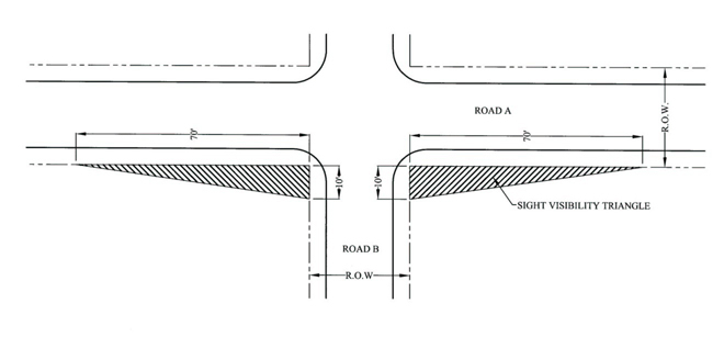
- Gates. Entry gates shall be constructed and maintained as required by and in accordance with Chapter 47 of the Henderson County Code, Entry Gates, and SR 3.7 (Gates and/or Guardhouses).
- Dead Ends, Cul-de-sacs and Turnarounds. Vehicle turnaround areas shall be provided at the end of all dead-end roads (excluding private driveway easements) that exceed 300 feet. Loop roads should be encouraged where possible in lieu of cul-de-sac or turnarounds. The reviewing agency may also require installation of turnarounds at:
- Intermediate locations along dead end roads with a centerline length of greater than 2,500 feet.
- The end of a phase of a project.
- An intermediate location along any road that exceeds 1,500 feet in length.
Acceptable alternative turnaround designs for residential subdivisions are shown in Figures 3C, 3D, and 3E. Turnaround areas of a dead-end road cul-de-sac shall have a radius of not less than 35 feet.
Figure 3C. Alternative Turnaround Design - Island
Not to Scale
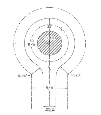
Figure 3D. Alternative Turnaround Design - Branch Turnaround
Not to Scale
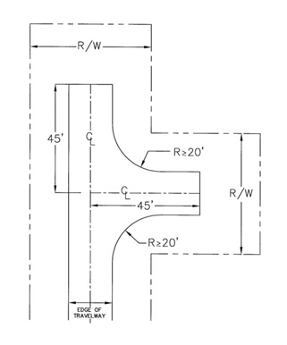
Figure 3E. Alternative Turnaround Design – T Turnaround
Not to Scale
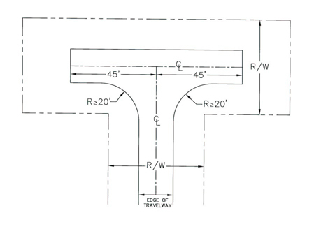
- Bridges. Bridges shall:
- Be engineered to a minimum weight capacity of 50,000 pounds (For purposes of emergency management vehicle access) and documentation shall be provided to indicate such (the 50,000 pound weight capacity requirement shall not apply to driveways);
- Adhere to State Road Standards for drainage, hydraulics and minimum live load;
- Adhere to standards for vertical clearance for roads (See Table 3.3);
- Provide a travelway width not less than the travelway width of the road on either side of the bridge, and in no case less than 12 feet in width;
- Include a paved or gravel turnout on each end of the bridge to provide space for at least one (1) vehicle to safely pull over and allow an oncoming vehicle to traverse the bridge where the travelway width is less than 18 feet and is proposed to accommodate two-way traffic; and
- Provide adequate line-of-sight distances for safe operation of two-way traffic.
- Right-of-way Width Reduction. Right-of-way width requirements may be reduced to 30 feet in width where no more than five (5) lots are proposed and it is unlikely (due to design, topographic conditions or existing development) that any road contained therein would be extended to serve more than five (5) lots.
- Centerline Curve Radius Reductions. Centerline curve radius reductions may be reduced to:
- 80 feet where the existing cross slope on private subdivision collector roads is 15 percent or greater, or
- 60 feet where the existing cross slope on private subdivision limited local residential subdivision roads or private subdivision local residential subdivision roads is 15 percent or greater.
- Shoulder Width Reduction. Shoulder width shall be reduced for:
- Private subdivision local roads and private subdivision collector roads to a minimum of two (2) feet in cases where the existing cross slope is 20 percent or greater; and
- Private subdivision collector roads to a minimum of four (4) feet in cases where the existing cross slope is greater than ten (10) but less than 20 percent or greater.
- Cut and Fill Slopes. Cut and fill slopes shall be reduced to 1:1 where the existing cross slope is 20 percent or greater. Additional erosion control measures are required in areas where cut and fill slopes utilize this reduction. Enforced by the Erosion Control Administrator.
Subpart E. Subdivision Improvement Guarantees
Where the required improvements have not been completed, prior to the submission of the final plat for approval, the approval of said plat shall be subject to the applicant guaranteeing the installation of the improvements within thirty (30) months provided the following:
- A minimum of 25 percent of the on site improvements (based on the total project cost that the applicant is guaranteeing) is in place. The required improvements shall include rough grading for all proposed roads that are part of said improvement guarantee
- All required Federal, State and Local permits for the development must be issued with copies provided to the Subdivision Administrator (include any required U.S.Army Corps of Engineers permits, NCDENR permits, water supply and distribution system permits, wastewater collection and treatment system permits, approvals for the extension of electrical power service and other necessary utilities, and all applicable Federal and State permits).
- All associated design plans and construction specifications for the required improvements (i.e. roads, bridges, water and sewer infrastructure, stormwater infrastructure, pedestrian infrastructure, etc.) including the design engineer’s release of such approved plans are submitted to the Subdivision Administrator.
Plans, specifications, quantities, unit costs and estimated total costs shall be provided by the applicant to the Subdivision Administrator. Cost estimates shall:
- Be prepared by a professional engineer licensed in N.C., or certified by a professional land surveyor or landscape architect who is routinely engaged in cost estimates and licensed in N. C., at the applicants’ expense. Water and sewer system infrastructure improvements shall be prepared by a professional engineer licensed in N. C. at the applicant’s expense.
- Provide a schedule for initiation and completion of work.
- Include separate estimates for roads, bridges, water and sewer infrastructure, stormwater infrastructure, pedestrian infrastructure, utilities (including electrical power, natural gas and communication lines), etc., consistent with the approved design plans construction specifications.
- Include separate estimates for any off-site infrastructure improvements such as roadways, stormwater system, water system, sanitary sewer system, etc., are required to be included in the improvement guarantee.
- Include all Federal and /or State mitigation fees due but not paid at the time of the execution of the improvement guarantee. Proof of payment for remediation fees shall be provided to the Subdivision Administrator.
- Include all professional engineering and land surveying fees associated with the bidding and award, construction contract administration and engineering certifications associated with the development of the infrastructure for the proposed development.
- Amount of Guarantee. The improvement guarantee shall be in the amount of 125 percent of the cost to complete the work as determined by cost estimates.
- Guarantee. The applicant shall guarantee the installation of such improvements in an amount equal to the improvement guarantee cost to complete the work as determined by cost estimates amount by either of the methods described below.
- Filing a performance or surety bond or an irrevocable standby letter of credit.
- Depositing a certified check or cash.
- Release of Funds. Portions of the improvement guarantee may be release as work progresses, provided the following:
- The applicant submits a new cost estimate as described in the §42-117.A (Amount of Guarantee) detailing the work that has been complete and the work that is remaining. The amount remaining under the improvement guarantee shall meet or exceed the cost of the remaining improvements.
- Funds shall not be released if the property is in violation of any laws until the violations are remedied to the satisfaction of the charging party.
- At total of not more than four (4) requests for release of funds shall be allowed. The first request for release is eligible when twenty-five (25) percent of the work is completed. The second and third request for release is eligible when fifty (50) percent and seventy-five (75) percent of the work is completed. The fourth and final release is eligible upon completion of all required improvements listed in the improvement guarantee. The release of funds must include a professional Engineer’s statement certifying the work has been satisfactorily completed.
- Approval. All guarantees shall be accompanied by a written agreement (performance agreement) specifying the terms and the amount of the guarantee. The Planning Director shall have the authority to approve all improvement guarantee applications taking into consideration the amount and terms of the guarantees for improvements (including time of initiation and completion of the work).
- Temporary Access and Construction Easement. The applicant shall provide temporary access and permanent construction easement s for all infrastructure improvements.
- Amount and Terms. The amount of the guarantee shall be sufficient to provide adequate funds to the County to ensure, in the case of default, the installation of all required improvements uncompleted at the time of default. All improvement guarantees shall comply with applicable statutory requirements and shall be satisfactory to the County Attorney or Staff Attorney as to form, sufficiency and manner of execution. Guarantees employing lending institutions shall require that those banking corporations be licensed to do business in North Carolina and be from a national association or FDIC registered group.
The following terms shall be stated in the performance agreement:
- The applicant shall be provided 15 days to identify a new security provider or prove alternate security where the security provider is in default, bankruptcy, or otherwise determined to be insolvent by the County after which time the County may redeem the improvement guarantee.
- The applicant shall provide the County with specific benchmarks for completion of work and, as a term of the agreement, should the applicant fail to meet the self-imposed benchmarks the county may redeem the improvement guarantee.
- If in violation of any other provision of this Chapter 42, Henderson County Land Development Code, where the applicant shall been notified of the violation, and the applicant has been provided the period for remediation authorized by the approving agency, and where applicant is in continued violation, the County may consider this to be a breach of the agreement and call the improvement guarantee to prevent further violation of Chapter 42, Land Development Code.
D. Time Limits. The improvement guarantee is valid for a period of eighteen (18) months from the date of execution.
E. Extensions. The Planning Director, upon proof of difficulty, may grant an extension for a maximum of (1) one additional year. Improvements not completed within thirty (30) months shall be in breach with the requirements of this section and the improvement guarantee and any and all monies and accrued interest shall be forfeited by the applicant.
F. Second Improvement Guarantee. If the Planning Director has found that the applicant has made a good faith effort in completing the required improvements within the thirty (30) months the County may allow the applicant to execute a second improvement guarantee. Said agreement much be in the form of cash on deposit equal to the cost as described in §42-117A (Amount of Guarantee) of the remaining improvements. The County shall assess and administrative fee equal to ten (10) percent of the new improvement guarantee monies.
If an applicant of a subdivision is in violation of any County Regulations (including Soil Sedimentation and Erosion Control Permits) the County will not release the improvement guarantee prior to the expiration date unless the violations are corrected.
The County may charge for the cost for construction and project administration for any improvement guarantee that is executed.
Subpart F. Application, Enforcement and Legal Status Provisions
The applicant for any subdivision review or approval procedure may submit, along with any initial application, an affidavit specifying an agent who may represent the owner in all matters.
Pursuant to NCGS §160D-801, and except where otherwise provided in this Chapter, no final plat of a subdivision within the jurisdiction of this Chapter shall be recorded by the Register of Deeds of Henderson County until it has been approved by the Subdivision Administrator, Technical Review Committee, or Planning Board as provided herein. The Register of Deeds shall not file or record a plat of the subdivision of land, any part of which is located within the jurisdiction of this Chapter that has not been approved in accordance with these provisions. In addition to meeting the requirements of this Chapter, subdivisions proposed within designated water supply watershed areas shall be subject to the provisions of the Water Supply Watershed Protection requirements of this Chapter, and the Water Quality Administrator or his designee shall certify on such plats that the subdivision complies with the provisions of the Water Supply Watershed Protection requirements of this Chapter.
Any plat of property exempted from the regulations of this Chapter shall be certified by the Subdivision Administrator or a professional land surveyor as exempt, prior to such plat being recorded. Such plat is not exempt from the other requirements set forth in this Chapter or any other local ordinances. Pursuant to NCGS §47-30 (f) 11 (Duty of the Surveyor), a professional land surveyor may certify that such plat represents an exception to the definition of subdivision and is not subject to the provisions of this Article III (Subdivision Regulations). Such plat may be recorded without being certified by the Subdivision Administrator. Any exemption from the regulations of this Chapter shall not be deemed an exemption from any other applicable ordinance. Any court-ordered subdivision should comply, to the maximum extent possible, with the provisions of this Chapter.
No building permit may be issued for any construction on any proposed lot shown on a development plan until a final plat has been approved and recorded, except that a building permit may be issued for one (1) structure on one (1) lot shown on any approved development plan prior to recordation of a final plat. The Building Services Department shall deny building permits for subdivision lots created in violation with the terms and conditions of this Chapter.
Where application for major or minor subdivisions is made with the intent that such divided property will be sold at land auction, the final plat shall clearly state the following: "The property herein is to be sold by auction. Any further subdivisions must meet applicable standards set forth in the Henderson County Land Development Code." In addition, restrictive covenants regarding road maintenance for any dedicated rights-of-way must be approved in advance by the appropriate reviewing agency and recorded prior to such auction.
Only one (1) application for a subdivision may be reviewed by any reviewing agency at any one (1) time on any of the original property boundaries. An application is only valid for up to one (1) year after its submission to the Planning Department. Applications submitted over one (1) year prior must be updated and resubmitted.
If an applicant of a phased minor or is in violation of any regulation in Article III (Subdivision Regulations) for the first phase of the subdivision then the applicant will not be allowed to continue developing future phases of the subdivision and any County issued permits may be revoked or suspended by the County. Upon verification by Henderson County Planning Staff that the subdivision no longer violates the provisions of Article III (Subdivision Regulations), subdivision approval and any suspended permits will become valid. The applicant may reapply pursuant to applicable provisions of the Land Development Code to have any revoked permits reinstated.
42-135. Traffic Impact Study
A Traffic Impact Study (TIS) may be required to evaluate the effect a proposed development will have on the County’s existing traffic system and may require specific improvements to mitigate the impact on public roads with the approval of NCDOT or applicable municipality.
- Requirement Thresholds. A TIS is required for any proposed development that meets any of the following requirement thresholds:
- Any residential subdivision proposing 100 or more lots/units.
- Any residential or nonresidential development proposed to generate an average daily traffic count of 1,000 plus vehicles per day or 100 plus trips during peak traffic hour. This traffic count must be based on the latest version of the Institute of Transportation Engineers (ITE) Trip Generation Manual.
- Any expansion or change to an existing or proposed residential or nonresidential development that would generate an additional 1,000 plus vehicles per day or 100 plus trips during peak traffic hour. This traffic count must be based on the latest version of the Institute of Transportation Engineers (ITE) Trip Generation Manual.
Notwithstanding the above, a TIS shall not be required if the property to be developed has been the subject of a TIS within the previous three (3) years and the projected trip generation of the newly proposed development is equal to or less than the previous TIS preformed and the trip distribution has not significantly changed.
- Traffic Impact Study (TIS) Guidelines.
- Any TIS, whether required or voluntarily, must be prepared by a licensed engineer and submitted as part, or as a condition, of the master plan approval or site plan approval. Prior to conducting the TIS, the developer must meet with County Staff, the Technical Review Committee, and NCDOT to identify certain assumptions that shall be addressed in the TIS.
- An executive summary shall be provided with the TIS outlining the following: (1) detailed description of the proposed development, (2) number of access points proposed and studied, (3) existing and future Level of Service (LOS) for studied intersections and road segments including the LOS at the time of build-out, (4) existing traffic counts for road(s) and intersection(s) studied and dates/times counts were conducted, (5) AM and PM Peak Hour Trips, (6) Average Daily Trips created by the development at build-out, (7) Existing Traffic Accident Counts, and (8) any recommended improvements.
- The TIS shall address the: (1) proposed land use, (2) site access and site distances at all proposed access points, (3) impacts on the transportation system from the proposed development, and (4) physical improvements or enforceable management strategies to mitigate negative impacts.
- The TIS shall take into consideration proposed/planned NCDOT roadway improvement projects as identified on the Metropolitan Transportation Improvement Program (MTIP), State Transportation Improvement Program (STIP), the French Broad River Metropolitan Planning Organization Long Range Plan, and the Comprehensive Transportation Plan.
- The TIS shall identify the improvements necessary to maintain Level of Service (LOS) D for roads and intersections as defined in the Highway Capacity Manual.
- Recommended improvements within the TIS shall take into account the Traffic Impact Study Improvement Requirements listed in §42-136 (Traffic Impact Study) (C).
- Traffic Impact Study (TIS) Improvement Requirements. The approving authority for all subdivisions requiring a TIS may require additional mitigation standards or offsite improvements provided when improvements are acceptable by NCDOT or applicable municipality. However, a TIS shall not be utilized as a means for the County to require the party developing the property to make needed transportation improvements remote from and not affected by the property for which the TIS is submitted, nor shall identified deficiencies in LOS automatically preclude approval of the proposed development.
- Left Turn Lane, Right Turn Lane, and/or Right Turn Taper: Based on requirements of the NCDOT Policy on Street and Driveway Access to North Carolina Highways or other NCDOT standards.
- Additional Right-of-Way: If a subject development falls along a road projected to be widened by NCDOT or an adopted County plan, additional right-of-way along the development’s road frontage shall be dedicated as deemed acceptable by NCDOT.
- Offsite Improvements: If a road segment or intersection is currently performing at LOS-D or better and is projected to perform at LOS-E or F at the time of build-out, improvements must be made to maintain the road segment or intersection at LOS-D. If a road segment or intersection is currently performing at LOS-E or F and is projected to continue to perform at LOS-E or F at the time of build-out, the TIS shall demonstrate how an LOS-D could be achieved and also specify what improvements must be made to ensure that the road segment or intersection is not degraded any further than the current levels. The County may require improvements be made to preserve the existing LOS.
- Other Necessary Improvements: Additional improvements may be required based on the TIS recommendations related to topographic/environmental conditions, sight distance, street offsets, conflicting movements, existing traffic accident counts, circulation, and other potential traffic issues resulting from the proposed development. Additionally, the approving authority may determine that additional improvements are necessary to ensure the safety and welfare of the County’s citizens and travelers.
42-136. Emergency Services Impact Report
An Emergency Services Impact Report (ESIR) may be required to evaluate the public safety of a proposed development and the effect it will have on the County’s existing Fire and Emergency Medical Services (EMS). The report and requirements are in addition to those requirements and review of the internal design of the development. An ESIR shall be required for subdivisions proposing one-hundred lots/units or more, or subdivisions proposing more than 50 units located more than five (5) road miles from a fire station and shall be submitted as part of master plan approval.
- Proximity and Impact to Existing Services. Residential and nonresidential subdivisions shall provide documentation to identify if a proposed development or portion thereof is outside of a Fire Insurance District or is more than five (5) road miles from an existing fire station. The developer shall also provide documentation identifying the response time to the nearest existing EMS station based on an average 35 miles per hour. The ESIR shall state the location of the EMS substation, the response time in minutes, the route from the proposed development including road names and classifications, number of passing areas and posted speed limits, and the method of calculation.
- Fire Suppression Water Supply. Residential and nonresidential subdivisions shall provide documentation to identify water resources for fire suppression. The developer shall also provide documentation identifying the type of water source (static or pressurized), number and spacing of hydrants, capacity, flow rate in gallons per minute, and static and residual pressures.
- Based on the findings of the ESIR and the recommendation of County Staff or the approving authority, a proposed development may be required to be built at a maximum density of one (1) unit per three (3) acres. However, the developer may volunteer to provide emergency equipment, vehicles, land and/or facilities to the County to serve the development in order to waive the density reduction, provided the County decides the site is appropriate for a new fire or EMS substation.
42-137. to 42-164. Reserved
42-165. General
The requirements set forth in this Article shall be complied with in addition to any other general or specific requirements of this Chapter. The regulations of this Article apply to: (1) the establishment and operation of a new use; (2) the entire property where any expansion of floor area/paved surface equals or exceeds 50 percent of the pre- expansion area; and (3) those portions of property which extend around and are parallel to the expansion of floor area/paved surface where the expansion area is less than 50 percent of the pre-expansion area. These requirements in no way relieve a use of having to meet all local, state and federal laws pertaining to the establishment and operation of that use.
Subpart A. Buffer Requirements
The landscaping standards of this subpart provide requirements for all buffering. This section provides standards for each buffer type. The following standards shall be in effect to provide an appropriate transition between uses, and compliance therewith is required for the establishment and operation of a new use.
Buffers will be determined by identifying the zoning districts of adjacent land use(s). Table 5.1 outlines buffers required between zones. Where the property shares a boundary with more than one (1) zone, the width of the most intense buffer shall be required along the perimeter of the area to be developed; however, the plant materials required shall be calculated and placed based on the respective applicable buffer. See §42-168 (Plant Material) for required plant material.
| Table 5.1 Buffer Requirements | |||
|---|---|---|---|
| Zoning District | Industrial | Commercial | Residential |
| Industrial | N/A | B1 | B2 |
| Commercial | B1 | N/A | B1 |
| Residential | B2 | B1 | N/A |
Table 5.2 describes the width and plant material requirements for the buffers identified in Table 5.1. The length of the perimeter of the area to be developed shall be used in determining the number of plants required.
| Table 5.2 Buffer Width And Plant Material Requirements | |||||||
|---|---|---|---|---|---|---|---|
| Buffer Type | Width (FT) | Plant Material Required Per 100 Linear Feet | |||||
| Deciduous Trees | Evergreen Trees | ||||||
| Large | Small | Large | Small | ||||
| B1 | 20 | 1 | 2 | 2 | 6 | ||
| B2 | 30 | 2 | 3 | 5 | 12 | ||
The placement of buffer plantings shall be at the discretion of the developer, and shall be approved as part of the site plan submitted. Trees or shrubs shall not be planted within five (5) feet of any property line to ensure maintenance for access and to avoid encroaching onto the adjacent property. Where a setback requirement is less than the buffer requirement, the buffer width shall override the setback width. Where a setback requirement is greater than the buffer requirement, plant material requirements shall still be applied and such plant materials shall be placed within the buffer area. Trees and shrubs shall be spaced to provide screening.
Subpart B. Parking Lot Landscaping Standards
The landscaping standards of this subpart provide requirements for all parking lots consisting of ten (10) or more spaces. The following standards shall be in effect for each parking lot of this size, and compliance therewith is required for the establishment of a new or expansion of an existing parking lot.
For every five (5) parking spaces one (1) small or large deciduous tree shall be required. Plant material shall be placed within the parking lot or within 20 feet of the perimeter of the parking lot. All parking spaces shall be within 60 feet of a tree, as measured from the tree trunk to any portion of a parking space.
When no buffer is required along front, side, and rear property lines of a development and parking is proposed within 20 feet of said property lines, a planting strip is required. The planting strip shall be a minimum of ten (10) feet in width and shall contain two (2) small or large deciduous or evergreen trees per 100 linear feet (see Figure 5A). A planting strip design may include small and large deciduous and evergreen trees and shrubs. For the purpose of a planting strip, six (6) shrubs shall be considered equivalent to one small or large deciduous or evergreen tree.
Figure 5A. Planting Strip
Not to Scale, Dimensions May Vary
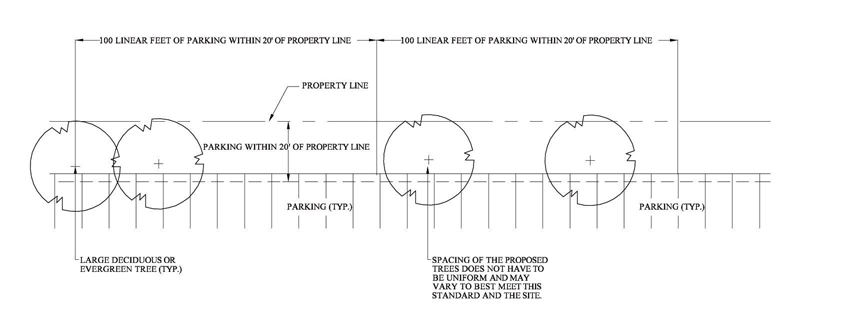
When parking lots contain multiple bays of parking, parking islands shall be installed and one-third (1/3) of the required plant material for the parking lot shall be placed within the islands. A parking island shall be a minimum area of 130 square feet per tree and a minimum width of eight (8) feet (measured from back-of-curb to back-of curb or edge or pavement to edge of pavement). Flat curbed islands or islands with curb cuts designed to be used as bio- retention areas (for treating stormwater runoff) should be used, where possible.
Plant material placed within six (6) feet of the edge of pavement must be bermed or have installed wheelstops or bollards to ensure that parking/moving cars do not damage the plant material. The Zoning Administrator may approve other methods to protect plant materials on a case-by-case basis.
Subpart C. Street Tree Requirements (Major Subdivisions)
The landscaping standards of this Article provide requirements in order to: (1) improve the aesthetic quality of the County; (2) encourage the preservation of existing trees and vegetation; (3) replenish trees and vegetation removed due to development; and, (4) reduce stormwater runoff, decrease erosion, improve water quality and protect wildlife habitat. These requirements in no way relieve a use of having to meet all local, state and federal laws pertaining to the establishment and operation of that use. The landscaping standards of this subpart provide requirements for street trees. This section provides general standards for street trees. The following standards shall be in effect for major subdivisions, and compliance therewith is required for the establishment of a major subdivision .
Trees shall be required at the rate of either:
- One (1) large deciduous tree per 50 linear feet of property abutting an internal road; or
- (Where overhead utilities are present) one (1) small deciduous tree per 40 linear feet of property abutting an internal road.
Trees shall be placed within the right-of-way or within 20 feet of the edge of the right-of-way. Trees may be placed in groups with a minimum spacing of no less than 15 feet and a maximum spacing of no more than 65 feet. Where street trees are required in the vicinity of existing/proposed above grade power lines the following shall apply: (1) trees may be placed up to 30 feet from the edge of the right-of-way to prevent interference with power lines; or, where this is not possible, (2) trees may be placed elsewhere within the development in proposed buffers, parking lot landscaping, etc..
Subpart D. Screening and Fencing Requirements
The landscaping standards of this subpart provide requirements for screening of uses. This section provides general and use specific standards for screening. The following standards shall be in effect for uses identified as requiring screening, and compliance therewith is required for the establishment of a new use or change in use where screening is required.
The exact placement of screen plantings shall be at the discretion of the designer or developer, and shall be approved as part of the site plan. Plants should be installed to provide a year-round screen when viewed from adjacent property. Trees or shrubs shall not be planted within five (5) feet of any property line to ensure maintenance access and to avoid encroaching onto the adjacent property. Proposed landscaping shall not interfere with the access and operation of the use which is being screened.
A screen shall not be required along those portions of the use where it runs parallel to and is within 20 feet of a Buffer (B1 or B2).
Screen Classes include:
- Screen Class One (1). A continuous hedge of evergreen shrubs (a minimum of eight (8) feet in height at maturity) planted in a five (5) foot strip spaced a maximum of eight (8) feet apart (see Figure 5B).
Figure 5B. Screen Class One (1) Not to Scale
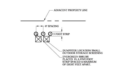
- Screen Class Two (2). A row of conical evergreen plants (a minimum of eight (8) feet in height at maturity) planted in the 15 foot area around that use and structure which is to be screened, and spaced a maximum of 15 feet apart (see Figure 5C).
Figure 5C. Screen Class Two (2) Not to Scale
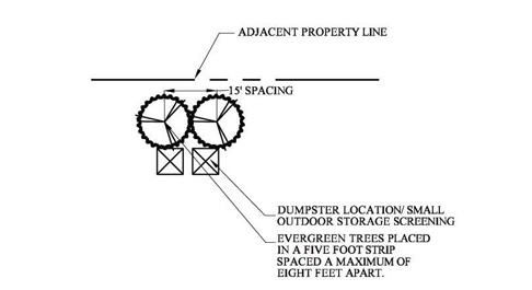
- Screen Class Three (3). A fence or wall constructed with a minimum height of six (6) feet, that is at least 75 percent opaque, where all spaces are evenly distributed, and with the finished side of the fence facing the adjacent property or road. Fences longer than 20 linear feet shall be landscaped with: a row of shrubs spaced a maximum of ten (10) feet apart, or a row of evergreen trees planted no more than 15 feet apart (see Figure 5D).
Figure 5D. Screen Class Three (3) Not to Scale
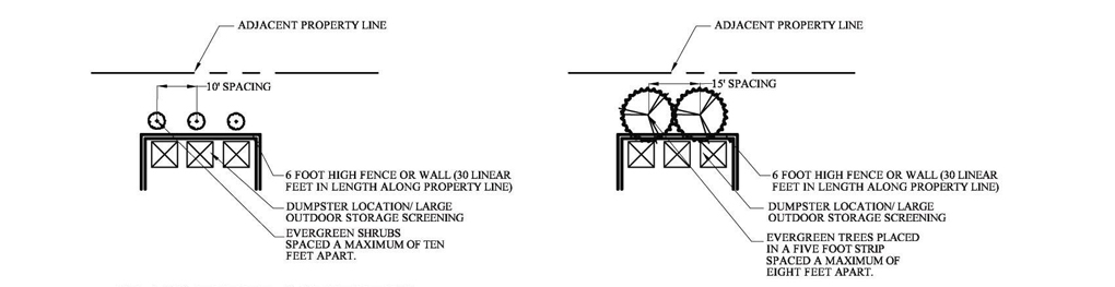
- Screen Class Four (4). A fence or wall constructed with a minimum height of eight (8) feet designed to facilitate the movement of maintenance and emergency response equipment to and from the proposed site. Gates should be secured at all times (unless for maintenance, inspection, or other unforeseen instances) following the completion of construction. Fencing may be in common with other existing uses on site. Fences longer than 20 linear feet shall be landscaped (excluding the gate area) with: a continuous hedge of evergreen shrubs planted in a five (5) foot strip spaced a maximum of eight (8) feet apart. The Zoning Administrator may require additional screening to minimize adverse impacts of ground level lighting (where installed) (see Figure 5E).
Figure 5E. Screen Class Four (4) Not to Scale
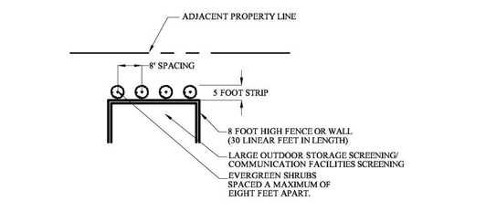
Subpart E. General Landscaping Standards
The landscaping standards of this subpart provide requirements, standards and options applicable to all other subparts and sections within this Article
- Plant Standards. Plant material shall: (1) meet the requirements of the latest edition of the American Standards for Nursery Stock (ANSI 260.1); (2) be healthy; and (3) be free of disease/insect infestation.
- Plant Material Size. Minimum plant size requirements are established to provide tree canopies and revegetate a site. Table 5.3 shows plant material size as required by this Chapter.
| Table 5.3. Tree and Shrub Requirements | |||
|---|---|---|---|
| Tree/Shrub Type | Height at Maturity (ft.) | Minimum Size at Planting | |
| Deciduous | |||
| Large Tree | ≥35 | 2 inches in caliper; 12 to 14 ft. in height | |
| Small Tree | <35 | 1 ½ inches in caliper; 8 to 10 ft. in height | |
| Shrub | >4 | 3 gallon container or 10 inch root ball; 18 inches in height | |
| Evergreen | |||
| Tree | >20 | 6 ft. in height | |
| Conical Tree | ≥ 15 | 3 gallon container or 10 inch root ball; 18 inches in height | |
| Shrub | >4 | 3 gallon container or 10 inch root ball; 18 inches in height | |
| Conical Shrub | ≥8 | 3 gallon container or 10 inch root ball; 18 inches in height | |
- Plant Material Placement. Plant material shall be permitted in the sight visibility triangle (see Figure 5F) provided the area within the sight visibility triangle remain permanently unobstructed between three (3) and ten (10) feet above grade.
Figure 5F. Sight Visibility Triangle Plantings
Not to Scale

Tree groupings and individual trees should be preserved. Preserved trees will be credited toward any requirement of this Article, and must be indicated on the site plan submitted.
- Tree Credit Rate. Preserved trees must be healthy and free of disease/insect infestation. Protection of critical root zone shall be required to ensure good health and condition (improper installation of protective measures will result in losing tree credits). Credits for preserving existing trees are indicated in Table 5.4. Critical root zone protection requirements are indicated in subsection B below.
- Critical Root Zone Protection. Critical root zone is the area around a tree calculated at a rate of one (1) foot radius for every one (1) inch of tree diameter. Protecting critical root zone involves installing tree protective fencing and (in some cases) silt fencing, as detailed below.
- Tree Protective Fencing. Tree protective fencing shall be installed (see Figure 5G and Figure 5H) around the critical root zone determined for each tree to be preserved.
Figure 5G. Tree Protective Fencing (Plastic)
Not to Scale
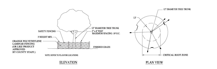
Figure 5H. Tree Protective Fencing (Post and Rail)
Not to Scale
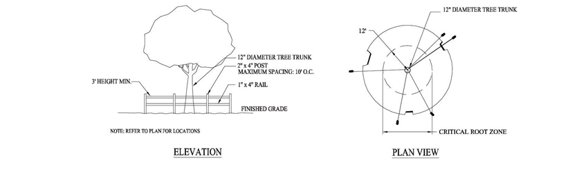
- Silt Fencing. Where silt fencing is required for sedimentation/erosion control such silt fencing shall be installed as per North Carolina Department of Environment and Natural Resources (NCDENR) regulations. Improper installation of silt fencing and/or lack of fencing (where required) will result in losing tree credits.
- Tree Protective Fencing. Tree protective fencing shall be installed (see Figure 5G and Figure 5H) around the critical root zone determined for each tree to be preserved.
- Replacement of Credited Trees. If a credited tree dies within in one (1) year of the date of issuance of a zoning permit, it must be replaced by the current property owner with the number of trees for which credit was received. (Example: A tree (12 inch caliper) credited towards the landscaping requirements dies, so the developer must replace it with two (2) trees that meet the installation size requirements as outlined in §42- 183 - Plant Specifications).
Where plant material is unavailable or during times of drought/inclement weather, the plant material required may be bonded. All guarantees shall be accompanied by a written agreement (performance agreement) specifying the terms and the amount of the guarantee. Following receipt of an improvement guarantees application, the Zoning Administrator shall prepare formal recommendations as to amount and terms of the guarantees for improvements, including time of initiation and completion of the work (and a requirement that temporary or permanent seeding be installed to prevent sedimentation and erosion problems until required plant material is placed). The time of completion for work shall not exceed six (6) months. The Zoning Administrator shall verify that the amount of the guarantee is sufficient to provide adequate funds to the County to ensure, in the case of default, the installation of all required improvements not completed at the time of default. All guarantees shall comply with applicable statutory requirements and shall be satisfactory to the County Attorney as to form, sufficiency and manner of execution. Guarantees employing lending institutions shall be institutions which are licensed to do business in North Carolina.
Site conditions or other reasons may justify the need to request an alternative method of compliance with this Article. The Technical Review Committee may alter the requirements of this Article so long as existing/proposed landscape features of the development comply with the intent of this Article. Requests for alternative compliance shall be accepted where:
- Topography, geologic features, drainage channels, streams, existing natural vegetation, overhead utilities, underground utilities, lot limitations (size, space or unusual shape), unique relationships to other properties, or other conditions make it unreasonable to meet landscape requirements; or
- An alternative compliance plan is equal or superior to normal compliance in its ability to fulfill the intent of this Article.
Subpart F. Landscaping Recommended Species List
|
|
|
Table 5.5 Recommended 1 Large Deciduous Trees |
|
|
Scientific Name |
Common Name |
|
Aesculus hippocastanum |
Common Horsechestnut |
|
Acer buergeranum |
Trident Maple |
|
Acer griseum |
Paperbark Maple |
|
Acer palmatum |
Japanese Maple |
|
Acer rubrum |
Red Maple |
|
Acer saccharum |
Sugar Maple |
|
Amelanchier canadensis |
Serviceberry |
|
Betula nigra |
River Birch |
|
Betula papyrifera |
Paper Birch |
|
Carya ovata |
Shagbark Hickory |
|
Carya glabra |
Pignut Hickory |
|
Carya cordiformis |
Hackberry |
|
Cercidiphyllum japonicum |
Katsura Tree |
|
Cladastris lutea |
Yellowwood |
|
Fagus grandiflora |
American Beech |
|
Fraxinus americana |
White Ash |
|
Fraxinus pennsylvanica |
Green Ash |
|
Gingko biloba |
Gingko (male only) |
|
Gymnocladus dioicus |
Kentucky Coffeetree |
|
Liquidambar rotundiloba |
Fruitless Sweetgum |
|
Liriodendron tulipifera |
Tulip Poplar |
|
Maackia amurensis |
Amur Maackia |
|
Nyssa sylvatica |
Black gum |
|
Oxydendron arborea |
Sourwood |
|
Platanus occidentalis |
Sycamore |
|
Quercus accustissima |
Sawtooth Oak |
|
Quercus alba |
White Oak |
|
Quercus bicolor |
Swamp White Oak |
|
Quercus coccinea |
Scarlet Oak |
|
Quercus falcata |
Southern Red Oak |
|
Quercus laurifolia |
Laurel Oak |
|
Quercus nigra |
Water Oak |
|
Quercua palustris |
Pin Oak |
|
Quercus phellos |
Willow Oak |
|
Quercua rubra |
Red Oak |
|
Quercus shumardi |
Shumard Oak |
|
Salix babylonica |
Weeping Willow |
|
Taxodium distichum |
Bald Cypress |
|
Tilia americana |
American Linden |
|
Tilia cordata |
Littleleaf Linden |
|
Ulmus alata |
Winged Elm |
|
Zelkova serrata |
Japanese Zelkova |
1 Species which are not included on the recommended species list may be used, but the applicant must show that the plant materials meet the standards of Article V and are appropriate for the area.
|
|
|
Table5.6 Recommended 1 Small Deciduous Trees |
|
|
Scientific Name |
Common Name |
|
Acer campestre |
Hedge Maple |
|
Carpinus caroliniana |
American Hornbeam |
|
Cercis canadensis |
Redbud |
|
Cornus florida |
Dogwood |
|
Cornus kousa |
Kousa Dogwood |
|
Cornus mas |
Corneliancherry Dogwood |
|
Cornus amomum |
Silky Dogwood |
|
Chionanthus virginicus |
Fringetree |
|
Crataegus phaenopyrum |
Washington Hawthorne |
|
Halesia tetraptera |
Mountain Silverbell |
|
Hamamelis mollis |
Chinese Witchhazel |
|
Hamamelis vernalis |
Vernal Witchhazel |
|
Koelreutaria paniculata |
Golden Rain-tree |
|
Ostrya virginiana |
Ironwood |
|
Prunus serrulata ‘Kwanzan’ |
Kwanzan Cherry |
|
Prunus subhirtella ‘Pendula’ |
Weeping Cherry |
|
Prunus yedoensis |
Yoshino Cherry |
|
Prunus caroliniana |
Carolina Cherry Laurel |
|
Rhus typhina |
Staghorn Sumac |
|
Stewartia koreana |
Korean Stewartia |
|
Styrax japonicus |
Japanese Snowball |
1 Species which are not included on the recommended species list may be used, but the applicant must show that the plant materials meet the standards of Article V and are appropriate for the area.
|
|
|
Table 5.74 Recommended 1 Evergreen Trees |
|
|
Scientific Name |
Common Name |
|
Chamaecyparis obtuse* |
Hinoki Falsecypress |
|
Chamaecyparis pisifera* |
Japanese Falsecypress |
|
Cryptomeria japonica* |
Japanese Cryptomeria |
|
Cupressocyparis leyandii* |
Leyland Cypress |
|
Juniperus Virginiana* |
Eastern Red Cedar |
|
Magnolia grandiflora* |
Southern Magnolia |
|
Magnolia grandiflora ‘Little Gem’* |
Little Gem Magnolia |
|
Picea abies* |
Norway Spruce |
|
Pinus strobus |
White Pine |
|
Pinus echinata |
Short-leaf Pine |
|
Pinus taeda |
Loblolly Pine |
|
Pinus virginiana |
Virginia Pine |
|
Thuja occidentalis* |
American Arborvitae |
|
Tsuga Canadensis* |
Eastern Hemlock |
|
Tsuga Caroliniana* |
Carolina Hemlock |
1 Species which are not included on the recommended species list may be used, but the applicant must show that the plant materials meet the standards of Article V and are appropriate for the area.
* Plants that are conical evergreens.
|
|
|
Table 5.8 Recommended 1 Deciduous Shrubs |
|
|
Scientific Name |
Common Name |
|
Abelia grandiflora |
Glossy Abelia |
|
Callicarpa americana |
Amercian Beautyberry |
|
Calycanthus floridus |
Common Sweetshrub |
|
Chaenomeles speciosa |
Flowering Quince |
|
Clethra alnifolia |
Sweet Pepperbush |
|
Cornus sericea |
Redosier Dogwood |
|
Forsythia x intermedia |
Border Forsythia |
|
Fothergilla gardenia |
Dwarf Fothergilla |
|
Fothergilla major |
Fothergilla |
|
Hydrangea species |
Hydrangea |
|
Ilex verticullata |
Winterberry |
|
Itea virginiana |
Virginia Sweetspire |
|
Nandina domestica |
Nandina |
|
Rhododendron species |
Azaleas |
|
Spirea species |
Spireas |
|
Viburnum species |
Viburnums |
1 Species which are not included on the recommended species list may be used, but the applicant must show that the plant materials meet the standards of Article V and are appropriate for the area.
|
|
|
Table 5.9 Recommended 1 Evergreen Shrubs |
|
|
Scientific Name |
Common Name |
|
Buxus sempervirens |
Common Boxwood |
|
Ilex species |
Hollies |
|
Juniperus chinensis pfitzeriana |
Pfitzer Juniper |
|
Juniperus chinensis hetzi |
Hetzi Juniper |
|
Leucothoe fontanesia |
Drooping Leucothoe |
|
Mahonia beleai |
Leatherleaf Mahonia |
|
Pieris floribunda |
Mountain Pieris |
|
Pieris japonica |
Japanese Pieris |
|
Prunus laurocerasus ‘Otto Luyken’ |
Otto Luyken Laurel |
|
Prunus laurocerasus ‘Schipkaensis’ |
Schip Laurel |
|
Prunus laurocerasus ‘Zabeliana’ |
Zabel Laurel |
|
Pyracantha coccinea |
Scarlet Firethorn |
|
Rhododendron species |
Rhododendrons |
|
Taxus species |
Yews |
|
Viburnum x pragense |
Prague Viburnum |
|
Viburnum rhytidophyllum |
Leatherleaf Viburnum |
1 Species which are not included on the recommended species list may be used, but the applicant must show that the plant materials meet the standards of Article V and are appropriate for the area.
|
|
|
Table 5.10. Holly Species that May Be Used for Screening1 |
|
|
Scientific Name |
Common Name |
|
Ilex x ‘Mary Nell’ |
Mary Nell Holly |
|
Ilex x ‘Nellie R. Stevens’ |
Nellie R. Stevens Holly |
|
Ilex species |
Red Holly hybrids |
|
Ilex species |
Blue Holly hybrids |
1 Species which are not included on the recommended species list may be used, but the applicant must show that the plant materials meet the standards of Article V and are appropriate for the area.
Subpart A. Off-Street Parking and Loading Standards
Permanent off-street parking and loading shall be required where the erection, alteration, enlargement, establishment or change in use of a structure or outside/outdoor use of land occurs. Any permit application or site plan submitted shall include information as to the location and dimensions of off-street parking and loading, the means of entrance and exit to each parking space, and the basis of determining the number of necessary parking spaces.
Parking shall be provided and maintained in accordance with the rates indicated below.
| Table 6.1 Required Parking | |
|---|---|
| Use Classification | Number of Parking Spaces Required |
| Residential-Single-Family Dwellings | Two (2) spaces per each dwelling unit |
| Residential-Multi-Family | One and one-half (1.5) spaces per each dwelling unit |
| Commercial, Office, Institutional, Civic | One (1) space per each 500 square feet of gross floor area |
| Industrial, Warehouse | One (1) space per each 4,000 square feet of gross floor area |
- Maneuvering Space.
- Single-Family Dwellings. Off-street parking for single-family dwellings which require backing into a residential service road shall be permitted provided that such movement can be made with reasonable safety and without interfering with other traffic.
- Nonresidential and Multifamily Development. Off-street parking for nonresidential and multifamily development shall not be designed in a manner which would require backing into a public road.
- Connectivity. Parking facilities shall be designed to connect with parking facilities on adjacent lots (where developed after the adoption date of this Chapter), where appropriate and approved by the adjacent property owner, to eliminate the need to use the abutting road(s) for cross movements.
- Handicapped Space. Handicapped spaces shall be provided as required by the North Carolina State Building Code.
- Lighting Standards. Lighting mitigation shall be required, as defined by this Chapter
- Landscaping. Parking lot landscaping shall be provided as set forth in Article V.
- Parking Island. Flat-curbed parking islands or islands with curb cuts designed for use as bio-retention areas for treating stormwater runoff are highly recommended.
- Fire Code. Nonresidential development and multifamily development parking areas shall comply with applicable fire code provisions as adopted by the State or the County.
- Entrances. Parking lot entrances shall be located at the furthest point from intersections as possible when the entrance is not part of an intersection.
- Drive-through Stacking Lanes. Access points for drive-through stacking lanes shall be located away from public roads and driveways so that queued vehicles do not block the traffic along public roads or the movement of other vehicles on site. The entrance and exit from a drive-through lane or designated drive-up parking space(s) shall be internal to the site and not a separate entrance/exit to or from the road. The total length of on-site stacking lane(s), taken together, shall be a minimum of 200 feet if site access is provided directly from a collector, thoroughfare, boulevard, or expressway; a minimum of 100 feet if site access is provided directly from a local road.
Parking shall be placed on site with the principal use and shall be designated as parking only for that use except where remote parking is requested. Remote parking is permitted if the off-street parking space cannot be reasonably provided on the same lot on which the principal use is located. Remote off-street parking must be located within 400 feet of the associated principal use, and shall not be reduced or encroached upon in any manner.
- Parking Spaces.
- Angled Parking Spaces. The minimum design vehicle footprint shall be a rectangle nine (9) feet in width and 19 feet in length unless a designated area for compact cars is provided.
- Parallel Parking Spaces. The minimum design vehicle footprint shall be a rectangle nine (9) feet in width and 22 feet in length unless a designated area for compact cars is provided.
The parking space standards are intended for one (1) vehicle, exclusive of adequate egress and ingress, drives, maneuvering space and landscaping. Figure 6A illustrates parking space designs.
Figure 6A. Parking Space Design for Angled and Parallel Parking
Not to Scale
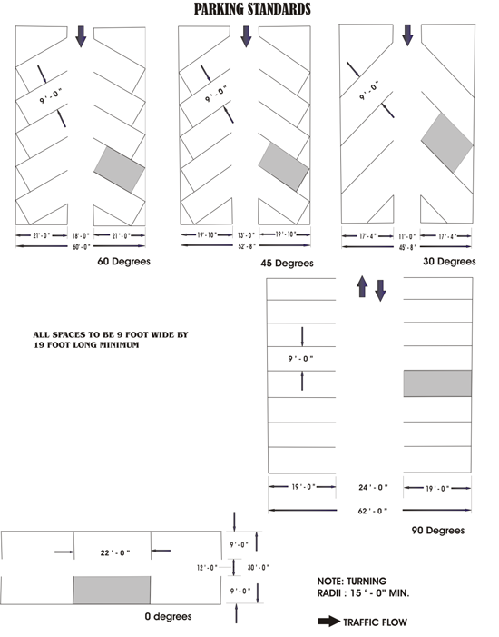
Every lot on which a commercial, office, civic, or warehouse, or industrial use is hereafter established shall provide and permanently maintain space at the rate indicated (see Table 6.2) for the loading, unloading and maneuvering of delivery vehicles off of roads or public alleyways. Such space shall have access to a public alley, private driveway, or, if such cannot be reasonably provided, a public road.
| Table 6.2 Off-Street Loading Space Requirements | |
|---|---|
| Gross Floor Area (sq. ft.) | Number of Spaces |
| 0 - 10,000 | 0 |
| 10,001 - 40,000 | 1 |
| 40,001 - 100,000 | 2 |
| 100,001 - 160,000 | 3 |
| 160,001 - 240,000 | 4 |
| 240,001 - 320,000 | 5 |
| 320,001 - 400,000 | 6 |
| Each 90,000 above 400,000 | 1 |
An off-street loading space (exclusive of adequate access drives and maneuvering space) shall have minimum dimensions of 12 feet by 60 feet and an overhead clearance of 14 feet in height above alley or road grade.
42-203. General
The requirements set forth in this Article shall be complied with in addition to any other general or specific requirements of this Chapter. The regulations of this section shall apply to all signs and sign structures erected, placed and/or maintained within the County, except as otherwise noted. The standards set forth in this Article are established in order to: (1) allow for the legitimate needs for identification of activities and commerce within the County; (2) improve the aesthetic quality of the County; (3) reduce intrusions on adjacent property; (4) protect property values; and (5) minimize undue distraction to motorists. These requirements in no way relieve a sign of having to meet all local, state and federal laws pertaining to the erection of that sign.
Subpart A. General Sign Standards
The sign standards of this subpart provide requirements and standards applicable to all other subparts and sections within this Article
The following are prohibited signs. Signs:
- Placed in the public right-of-way (except as erected for governmental purposes);
- Resembling and/or obscuring traffic signals;
- Obstructing access to drives, doors, walks, windows, fire escapes or fire escape routes;
- Which are animated and/or flashing (as defined by this Chapter);
- On the surface of lake/river water (except those navigational and warning signs);
- On vehicles parked and located for the purposes of displaying such a sign, where such vehicle is either a part of the sign or sign structure; and
- Billboards (an outdoor advertising sign 380 square feet in area or greater).
A sign permit shall be required for all nonexempt signs in accordance with the provisions of this Article (See §42- 353 - Sign Permits).
Signs shall be placed a minimum of 15 feet from edge of pavement or from back of curb (as applicable), and shall be located out of the road right-of-way. Signs are not permitted in a sight visibility triangle. Signs that are placed in the road right-of-way may be removed and disposed of, without notice, by authorized County personnel.
Sign area shall be the product of the maximum vertical distance (from the highest point to the lowest point on the sign face) and the maximum horizontal distance (across the sign face) (see Article XIV (Definition) for the definition of “Sign”). Sign area shall be calculated by the Zoning Administrator in accordance with Figures 7A and 7B.
Figure 7A. Sign Area Determination
Not to Scale
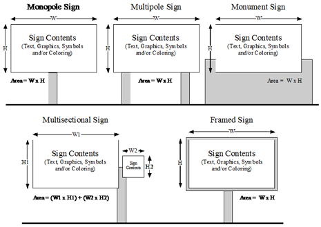
Figure 7B. Sign Area Determination for Nonrectangular Signs
Not to Scale
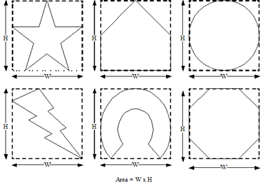
Lighting mitigation shall be required as defined by this Chapter for all signs
A sign indicating the address of a property shall be provided as required by and in accordance with Chapter 41 of the Henderson County Code, Property Addressing.
Subpart B. Exempt Sign Standards
The sign standards of this subpart identify exempt signs and provide requirements and standards for exemption.
The following signs are permitted in all districts (unless otherwise indicated), and shall not require a sign permit as long as in conformance with the applicable standards. All exempt signs may have one (1) or two (2) faces. Lighting of signs shall be installed in such a manner that the source of light (the bulb) is shielded and not visible from the adjacent roadway.
- Flags/Insignia.
- Maximum Area. Two hundred (200) square feet per face.
- Off Premise Sign.
- Maximum Area. Ten (10) square feet per face.
- Maximum Height. Five (5) feet.
- Permitted Districts. Permitted in all zoning districts.
- On Premise Sign in Residential and Local Commercial Zoning Districts.
- Maximum Area. Sixteen (16) square feet per face.
- Maximum Height. Eight (8) feet.
- On Premise Sign in Commercial, Office Institutional and Industrial Zoning Districts (excluding the local commercial zoning district).
- Maximum Area. Thirty-six (36) square feet per face.
- Maximum Height. Eight (8) feet.
- Temporary Sign.
- Maximum Area. Thirty-two (32) square feet per face (residential and local commercial zoning district); seventy-two (72) square feet per face (nonresidential zoning district excluding the local commercial zoning district). Banners up to two hundred (200) square feet per face.
- Maximum Height. Ten (10) feet (residential and local commercial zoning district); eighteen (18) feet (nonresidential zoning district excluding the local commercial zoning district).
- Removal. Such signs shall be temporary in nature, no longer than 30 days per occurrence and only once per calendar year per lot of record.
Subpart C. On-Premise Sign Standards
The sign standards of this subpart provide requirements for signs based on the general use district in which they are located. This subpart provides general standards for all signs within a general use district as well as sign specific standards for certain types of signs associated with certain uses or types of development. The following standards shall be in effect to provide appropriate signage for uses, and compliance therewith is required for the erection of a new sign.
The following sign regulations shall apply in residential and local commercial zoning districts.
- Freestanding Signs. Freestanding signs are permitted where intended to identify entrances to a community, single-tenant development, or multi-tenant development and shall adhere to the following standards.
- Sign Type. Monument or ground signs only are permitted.
- Maximum Number by Sign Type.
- Community Identification Entrance Sign. One (1) double-faced or two (2) single-faced freestanding signs is/are permitted per community entrance (but shall be placed at to no more than two (2) entrances).
- Single-Tenant Development Sign. One (1) freestanding sign is permitted per lot. One (1) additional freestanding sign is allowed for corner or double-fronted lots.
- Maximum Area. Thirty-two (32) square feet per face.
- Maximum Faces. Two (2) faces per sign.
- Maximum Height. Ten (10) feet.
- Illumination. Lighting of signs shall be installed in such a manner that the source of light (the bulb) is shielded and not visible from adjacent roadways.
- Attached Signs. Attached signs shall adhere to the following standards.
- Sign Type. Window, wall, suspended, awning and changeable copy (as part of a permanent sign) signs only are permitted.
- Sign Clearance. Any attached sign projecting 12 inches from a wall shall have a minimum nine (9) foot clearance over sidewalks and 14 foot clearance over roads, drives and alleys (no projection is allowed in any right-of-way).
- Maximum Area. Ten (10) percent of any wall area fronting a road and/or building facade, up to a maximum of 250 square feet. a
- Illumination. Lighting of signs shall be installed in such a manner that the source of light (the bulb) is shielded and not visible from adjacent roadways.
- Prohibited Signs. Portable, animated and flashing signs are prohibited.
- Electronic Message Sign. Electronic message signs are allowed with a special use permit in the residential and local commercial zoning districts.
The following sign regulations shall apply in office institutional, commercial and industrial districts (excluding the local commercial zoning district):
- Freestanding Signs.
- Sign Type. Monument or ground signs only are permitted when the sign height is 18 feet or less. Pole, monument and ground signs are permitted when the sign height is greater than 18 feet.
- Maximum Number by Sign Type.
- Single-Tenant Development Sign. One (1) freestanding sign is permitted per lot. One (1) additional freestanding sign is allowed for corner or double-fronted lots.
- Multi-Tenant Development Sign. One (1) double-faced or two (2) single-faced signs is/are permitted per development entrance (but shall be placed at to no more than two (2) entrances).
- Office Institutional and Commercial Subdivision Entrance Sign. One (1) double-faced or two (2) single-faced signs is/are permitted per subdivision entrance (but shall be placed at to no more than two (2) entrances).
- Maximum Area. Seventy-two (72) square feet per face. Where a sign is located within 500 feet of the right-of-way line of Interstate 26 the maximum area shall be 200 square feet per face.
- Maximum Faces. Two (2) faces per sign.
- Maximum Height. Eighteen (18) feet. Where a sign is located within 500 feet of the right-of–way line of Interstate 26 the maximum height shall be 75 feet (as measured from the road grade of the interstate).
- Illumination. Lighting of signs shall be installed in such a manner that the source of light (the bulb) is shielded and not visible from adjacent roadways.
- Attached Signs.
- Sign Type. All attached signs are permitted.
- Sign Clearance. Any attached sign projecting 12 inches from a wall shall have a minimum nine (9) foot clearance over sidewalks and 14 foot clearance over roads, drives and alleys (no projection is allowed in any right-of-way).
- Maximum Area. Ten (10) percent of any wall area fronting a road and/or building facade, up to a maximum of 250 square feet.
- Illumination. Lighting of signs shall be installed in such a manner that the source of light ( the bulb) is shielded and not visible from adjacent roadways.
- Prohibited Sign. Portable, animated and flashing signs are prohibited.
- Electronic Message Sign. Electronic message signs are allowed.
The following sign regulations shall apply in Industrial Districts.
- Freestanding Signs.
- Sign Type. All freestanding signs are permitted.
- Maximum Number by Sign Type.
- Single-Tenant Development Sign. One (1) freestanding sign is permitted per lot. One (1) additional freestanding sign is allowed for corner or double-fronted lots.
- Multi-Tenant Development Sign. One (1) double-faced or two (2) single-faced signs is/are permitted per development entrance (but shall be placed at to no more than two (2) entrances).
- Industrial Subdivision Sign. One (1) double-faced or two (2) single-faced signs is/are permitted per subdivision entrance (but shall be placed at to no more than two (2) entrances).
- Maximum Area. Seventy-two (72) square feet per face.
- Maximum Faces. Two (2) faces per sign.
- Maximum Height. Eighteen (18) feet. Where a sign is located within 500 feet of the right-of-way of Interstate 26 the maximum height shall be 75 feet (as measured from the road grade of the interstate).
- Illumination. Lighting of signs shall be installed in such a manner that the source of light (the bulb) is shielded and not visible from adjacent roadways.
- Attached Signs.
- Sign Type. All attached signs are permitted.
- Sign Clearance. Any attached sign projecting 12 inches from a wall shall have a minimum nine (9) foot clearance over sidewalks and 14 foot clearance over roads, drives and alleys (no projection is allowed in any right-of-way).
- Maximum Area. Ten (10) percent of any wall area fronting a road and/or building facade, up to a maximum of 250 square feet.
- Illumination. Lighting of signs shall be installed in such a manner that the source of light (the bulb) is shielded and not visible from adjacent roadways.
- Prohibited Sign. Portable, animated and flashing signs are prohibited.
- Electronic Message Sign. Electronic message signs are allowed.
Subpart D. Off-Premise Sign Standards
The sign standards of this subpart identify districts in which outdoor advertising signs are permitted and provide requirements and standards therefore. The following standards shall be in effect to provide appropriate outdoor advertising signage (except for those signs which are exempt or prohibited by this Article), and compliance therewith is required for the erection of a new outdoor advertising sign.
Outdoor advertising signs are permitted only in commercial and industrial districts where they are located in the Utility Service Area (USA) as identified by the Comprehensive Plan. Outdoor advertising signs shall be classified based on size and include: Outdoor Advertising Signs Type A, B and C (see Table 7.1).
| Table 7.1 Outdoor Advertising Sign Requirements | ||||
|---|---|---|---|---|
| Outdoor Advertising Sign | Square Feet Permitted | Maximum Height (ft.)² | Minimum Setback (ft.)³ | Spacing (linear ft.) |
| Type A | 0 to 72 | 25 | 10 | 1,000 |
| Type B | >72-300 | 35 | 20 | 1,000 |
| Type C | >300-380 | 35 | 20 | 1,000 |
- Signs greater than 380 square feet are considered billboards and are not permitted in the County.
- Maximum height shall be measured from the existing road grade to the uppermost point on the sign structure.
- Minimum setback shall be measured horizontally form the adjacent edge of right-of-way to the nearest edge of the sign structure, provided that no part of the sign or sign structure shall encroach upon a public right-of-way. Where property abuts more than one (1) road, signs shall be set back an equivalent distance from each road no less than the minimum setback required.
Outdoor advertising signs shall be spaced so that such outdoor advertising sign (or its structure) is placed no closer to the next outdoor advertising sign (or its structure) or any existing adjacent residence than the minimum spacing distance required (see Table 7.1). Spacing shall apply to outdoor advertising signs located on either side of a road. The minimum distance between signs or between a sign and a residence shall be measured horizontally between the nearest points on either structure. If, because of terrain, vegetation or practical difficulties, a point-to-point accurate measurement cannot be obtained, the Zoning Administrator may extend any point of measurement to a logical corresponding location and measure from this point. Using the extended measuring method a variation of five (5) percent is acceptable for the purpose of this Article.
The minimum distance between a sign structure and a residence shall not be less than 1,000 feet, except:
- Where the adjacent residence is a nonconforming use;
- Where the sign was erected after the original effective date of this Article (May 21, 1986, as amended) and predates a residence, the sign shall not be nonconforming because of distance from the residence;
- Where the sign was erected prior to the effective date of this Article (May 21, 1986 as amended) and duly registered, the sign shall not be nonconforming because of distance from another sign or a residence; or
- Where the topography obscures the sign from sight by the residents of the dwelling.
The spacing requirement may be reduced by up to 25 percent where the topography obscures the sign from sight by the residents of the dwelling.
Subpart E. Sign Maintenance
Maintenance requirements must be observed for all signs visible from any public road or highway within the jurisdiction of this Chapter. A sign in a state of disrepair shall be considered in violation of this Chapter. A sign shall be in a state of disrepair and require maintenance where the sign and its structure are:
- More than 20 percent covered with disfigured, cracked, ripped or peeling paint or poster paper (or any combination of these conditions);
- More than 15 degrees from the perpendicular as a result of bent/broken sign facing or supports, and/or loose appendages/struts;
- Obscured from the road/highway from which it is to be viewed by weeds, vines or other vegetation growing on it; and/or.
- To be illuminated, but are only partially illuminated.
42-230 General
This Article reflects and incorporates the Flood Damage Prevention, Water Supply Watershed Protection, Perennial and Intermittent Surface Water Buffers, Protected Mountain Ridges, and Soil Erosion and Sedimentation Control Ordinances previously adopted by the County. The purpose of this Article is to consolidate these existing ordinances into one article of the Land Development Code. This Article also includes stormwater management regulations for the purposes of improving the County’s water quality and quantity.
Subpart A. Flood Damage Prevention
The following sections are incorporated herein by reference and considered to be a part of the regulations of this Article VIII, Subpart A: §42-307 (Henderson County Flood Damage Prevention Board), §42-311 (Henderson County Floodplain Administrator),§42-350 (Floodplain Development Permits), §42-355 (Special Fill Permits), §42- 368 (Variances (Flood Damage Prevention), §42-378 (Violations of Article VIII (Natural Resources) Subpart A (Flood Damage Prevention), §42-379 (Appeals), and §42-391 (Definitions).
The Legislature of the State of North Carolina has in Part 6 of Article 21 of Chapter 143 and Article 6 of Chapter 153A; and Article 7, 9, and 11 of Chapter 160D of the North Carolina General Statutes (NCGS), delegated local governmental units the authority to adopt regulations designed to promote the public health, safety, and general welfare.
- The flood prone areas with the jurisdiction of Henderson County are subject to periodic inundation which results in loss of life, property, health and safety hazards, disruption of commerce and governmental services, extraordinary public expenditures of flood protection and relief, and impairment of the tax base, all of which adversely affect the public health, safety, and general welfare.
- These flood losses are caused by the cumulative effect of obstructions in floodplains causing increases in flood heights and velocities and by the occupancy in flood prone areas of uses vulnerable to floods or other hazards.
The objectives of this Subpart A are to:
- Protect human life, safety and health;
- Minimize expenditure of public money for costly flood control projects;
- Minimize the need for rescue and relief efforts associated with flooding and generally undertaken at the expense of the general public;
- Minimize prolonged business losses and interruptions;
- Minimize interruptions and disruptions of family life caused by flooding;
- Minimize damage to public facilities and utilities (i.e. water and gas mains; electric, telephone and sewer lines; and streets and bridges that are located in flood prone areas;
- Help maintain a stable tax base by providing for the sound use and development of flood prone areas;
- Permit and encourage the retention of open land uses which will be so located and designed as to constitute a harmonious and appropriate part of the physical development of the community and which will not impede the flow of flood waters;
- Prevent victimization by ensuring that potential land, home and business buyers are notified that property is located in an identified flood hazard area; and
- Prevent increased flood levels caused by unwise floodplain development.
- Minimize damage to private and public property due to flooding;
- Ensure that potential buyers are aware that property is in a Special Flood Hazard Area;
- Maintain the natural and beneficial functions of the floodplains; and
- Make flood insurance available to the community through the National Flood Insurance Program.
It is the purpose of this Subpart A to promote public health, safety, and general welfare and to minimize public and private losses due to flood conditions within flood prone areas by provisions designed to:
- Restrict or prohibit uses that are dangerous to health, safety, and property due to water or erosion hazards or that result in damaging increases in erosion, flood heights or velocities;
- Require that uses vulnerable to floods, including facilities that serve such uses, be protected against flood damage at the time of initial construction;
- Control the alteration of natural floodplains, stream channels, and natural protective barriers, which are involved in the accommodation of floodwaters;
- Control filling, grading, dredging, and all other development that may increase erosion or flood damage; and
- Prevent or regulate the construction of flood barriers that will unnaturally divert flood waters or which may increase flood hazards to other lands.
The provisions of this Subpart A shall apply to all Special Flood Hazard Areas within (1) the unincorporated areas of Henderson County lying outside the extraterritorial jurisdiction of any municipality, and (2) the incorporated areas and extraterritorial jurisdiction of any municipality specifically requesting its enforcement by Henderson County upon the agreement of the Henderson County Board of Commissioners, in accordance with the Flood Insurance Study (FIS) and its accompanying Flood Insurance Rate Map(s) (FIRM), for Henderson County dated October 2, 2008. (In making such a request, the municipality must comply with the requirements of NCGS §160D-923). Unless otherwise provided herein, in no instance shall this subpart apply to any area which is not duly established and identified as a Special Flood Hazard Area, either by the methods listed in §42-232.2 (Basis for Establishing the Special Flood Hazard Areas), or as shown on the Flood Insurance Study (FIS) and its accompanying Flood Insurance Rate Map(s) (FIRM), for Henderson County. The Chapter and map shall be on file in the office of Henderson County Floodplain Administrator.
The Special Flood Hazard Areas are those identified under the Cooperating Technical State (CTS) agreement between the State of North Carolina and the Federal Emergency Management Agency (FEMA) in its Flood Insurance Study (FIS) and its accompanying Flood Insurance Rate Map(s) (FIRM), for Henderson County dated October 2, 2008, which are adopted by reference and declared to be part of this Chapter, and all revisions thereto.
NOTE: If detailed topographic mapping or surveying shows that a building site adjacent to a Special Flood Hazard Area is below the Base Flood Elevation, it must be regulated as being within the Special Flood Hazard Area, even if not shown within the boundaries of the Special Flood Hazard Area shown in the FIRM or any accompanying maps. For regulatory purposes, flood elevations are the ruling guideline.
A Floodplain Development Permit shall be required in conformance with the provisions of this Subpart A and §42- 349 (Floodplain Development Permits) prior to the commencement of any development activities within Special Flood Hazard Areas as determined in §42-232.2 (Basis for Establishing the Special Flood Hazard Areas).
No structure or land shall hereafter be located, extended, converted, altered, or developed in any way without full compliance with the terms of this subpart and other applicable regulations.
- Subpart A is not intended to repeal, abrogate, or impair any existing easements, covenants, or deed restrictions. However, where this Subpart A and another regulation conflict or overlap, whichever imposes the more stringent restrictions shall prevail.
- The following may impose additional regulations for land uses and structures located in any portion of a floodplain and are hereby adopted and incorporated into this Subpart A by reference as though they were copied herein fully. However, where this Subpart A and another regulation conflict or overlap, whichever imposes the more stringent restrictions shall prevail.
- The International Building Codes, as adopted by the North Carolina Building Code Council and enforced by State and local code enforcement officials, and including all volumes.
- The Southern Building Code Congress International “SBCCI Standard for Floodplain Management” SSTD 4-89,
- The US Army Corps of Engineers “Flood Proofing Regulations” – EP 11651-2-314, December 15, 1995.
- Federal Emergency Management Agency “Managing Floodplain Development in Approximate Zone A Areas,” April, 1995.
- The granting of a permit under the provisions of this Subpart A and §42-349 (Floodplain Development Permits) or §42-354 (Special Fill Permits) shall in no way affect any other type of approval required by any other statute or ordinance of the State or any political subdivision of the State, or of the United States, but shall be construed as an added requirement.
- No permit for the construction of any structure to be located within a floodplain shall be granted unless the applicant has first obtained the permit required by this Subpart A.
In the interpretation and application of this Subpart A, all provisions shall be:
- Considered as minimum requirements;
- Liberally construed in favor of the governing body; and
- Deemed neither to limit nor repeal any other powers granted under State statutes.
The degree of flood protection required by this Subpart A is considered reasonable for regulatory purposes and is based on scientific and engineering consideration. Larger floods can and will occur. Actual flood heights may be increased by man-made or natural causes. Subpart A does not imply that land outside the Special Flood Hazard Areas or uses permitted within such areas will be free from flooding or flood damages. Subpart A shall not create liability on the part of Henderson County or by any officer or employee thereof for any flood damages that result from reliance on this Subpart A or any administrative decision lawfully made hereunder.
The provisions of Subpart A, related to administration can be found in the following sections:
- Designation, Duties and Responsibilities of Floodplain Administrator. (See §42-310 (Henderson County Floodplain Administrator)).
- Floodplain Development Permit Application Requirements and Fees. (See §42-349 - Floodplain Development Permits).
- Special Fill Permit Procedures and Fees. (See §42-354 - Special Fill Permits).
- Variance Procedures. (See §42-368 (Variances - Flood Damage Prevention).
- Appeal Procedures. (See §42-379 - Appeals).
- Corrective Procedures and Penalties for Violation. (See §42-378 (Violations of Article VIII (Natural Resources) Subpart A (Flood Damage Prevention).
In all Special Flood Hazard Areas the following provisions are required.
- In the flood fringe area as indicated on the FIRM, no more than 20 percent of the total of the flood fringe area may be filled, except that additional fill may be permitted in the flood fringe pursuant to a special fill permit (See §42-354 (Special Fill Permits)).
- In the floodway area as indicated on the FIRM, fill may be permitted in the floodway pursuant to a special fill permit (See §42-354 (Special Fill Permits))
- All new construction and substantially improvements shall be:
- Designed (or modified) and adequately anchored to prevent flotation, collapse, or lateral movement of the structure.
- Constructed with materials and utility equipment resistant to flood damage.
- Constructed by methods and practices that minimize flood damages.
- All new utility equipment, substations, lines and other materials used in the provision of services to the public such as telephone, electricity, natural gas, and cable television shall be located outside a floodplain, unless no viable alternative exists.
- Electrical, heating, ventilation, plumbing, air conditioning equipment, and other service facilities shall be designed and/or located so as to prevent water from entering or accumulating within the components during conditions of flooding to the Regulatory Flood Protection Elevation. These include but are not limited to HVAC equipment, water softener units, bath/kitchen fixtures, ductwork, electrical/gas meter panels/boxes, utility/cable boxes, appliances (i.e. washers, dryers, refrigerator, etc.), hot water heaters, electric outlets/switches.
- All new and replacement water supply systems shall be located outside the Special Flood Hazard Area, unless no other viable alternative exists. Where they must be placed in the SFHA the systems shall be designed to minimize or eliminate infiltration of flood waters into the system, and also to meet all other applicable State and local requirements.
- All new and replacement sanitary sewage and on-site waste disposal systems shall be located outside the Special Flood Hazard Area, unless no other viable alternative exists. Where they must be placed in the SFHA the systems shall be designed to minimize or eliminate infiltration of flood waters into the systems and discharges from the systems into flood waters, and also to meet all other applicable State and local requirements.
- On-site waste disposal systems constructed near or adjoining Special Flood Hazard Areas shall be located and constructed to avoid impairment to them or contamination from them during flooding.
- No new private wells shall be located within the Special Flood Hazard Area unless no viable alternative exists and that such wells meet all other applicable state and local requirements. Private wells constructed near or adjoining Special Flood Hazard Areas shall be located and constructed to minimize or eliminate infiltration of flood water into the system.
- Any alteration, repair, reconstruction, or improvements to a structure which is in compliance with the provisions of this Subpart A, shall meet the requirements of new construction as contained in this Subpart A.
- Any fill material on which a structure is located shall:
- Be extended to grade ten (10) feet beyond the limits of the structure foundation;
- Be graded to drain;
- Be protected against erosion;
- Have a side slope no steeper than two (2) feet horizontal to one (1) foot vertical;
- Not contain any contaminated, toxic or hazardous materials; and
- Be approved before placement.
- Nonconforming structures or other development may not be enlarged, replaced, or rebuilt unless such enlargement or reconstruction is accomplished in conformance with the provisions of this Subpart A. Provided, however, nothing in this subpart shall prevent the repair, reconstruction, or replacement of a structure existing on the original effective date of these regulations (July 5, 2005) and located totally or partially within the floodway, non-encroachment area, or stream setback, provided that the bulk of the structure below the Regulatory Flood Protection Elevation in the floodway, non-encroachment area, or stream setback is not increased and provided that such repair, reconstruction, or replacement meets all of the other requirements of this Subpart A, and nothing in this Subpart A shall prevent the permitted maintenance, repair, reconstruction or replacement of agriculture-related water diversion structures where the permit for the same is granted by other than Henderson County. No permit shall be required from Henderson County to reconstruct agricultural development which pre-exists the original effective date of these regulations (July 5, 2005).
- The following are permitted uses for the flood fringe: all uses otherwise permitted by the applicable land use regulations, so long as such uses are in compliance with the terms of this Subpart A.
- New solid waste disposal facilities and sites, hazardous waste management facilities, solid waste sites, salvage yards, and chemical storage facilities shall not be permitted in Special Flood Hazard Areas, except by variance as specified in Subpart A and §42-368 (Variances (Flood Damage Prevention)). A structure or tank for chemical or fuel storage incidental to an allowed use, including but not limited to agriculture, or to the operation of a water treatment plant or wastewater treatment facility may be located in a Special Flood Hazard Area only if the structure or tank is either elevated or flood proofed to at least the Regulatory Flood Protection Elevation and certified according to §42-349 (Floodplain Development Permits) C(2) (Certification Requirements).
- All subdivision and other development proposals shall:
- Be consistent with the need to minimize flood damage;
- Have public utilities and facilities such as sewer, gas, electrical, and water systems located and constructed to minimize flood damage;
- Have adequate drainage provided to reduce exposure to flood hazards; and
- Have received all necessary permits from those governmental agencies for which approval is required by Federal or State law, including Section 404 of the Federal Water Pollution Control Act Amendments of 1972, 33 U.S.C. 1334.
- When a structure is partially located in a Special Flood Hazard Area, the entire structure shall meet the requirements for new construction and substantial improvements.
- When a structure is located in multiple flood hazard zones or in a flood hazard risk zone with multiple Base Flood Elevations (BFEs), the provisions for the more restrictive flood hazard risk zone and the highest Base Flood Elevation (BFE) shall apply.
In all Special Flood Hazard Areas where BFE data has been provided, as set forth in this Subpart A, the following provisions in addition to those required in §42-234.1 (General Standards) are required:
- Residential Construction. New construction and substantial improvement of any residential structure (including manufactured/mobile homes) shall have the reference level, including basement, elevated no lower than the Regulatory Flood Protection Elevation.
- Nonresidential Construction. New construction and substantial improvement of any nonresidential structure shall have the reference level, including basement, elevated no lower than the Regulatory Flood Protection Elevation. Structures located in A, AE and AO Zones may be flood proofed to the Regulatory Flood Protection Elevation in lieu of elevation provided that all areas of the structure, together with attendant utility and sanitary facilities, below the required flood protection elevation are watertight with walls substantially impermeable to the passage of water, using structural components having the capability of resisting hydrostatic and hydrodynamic loads and the effect of buoyancy. For AO Zones, the flood proofing elevation shall be in accordance with §42-234.7 (Standards for Areas of Shallow Flooding (Zone AO)). A registered professional engineer or architect shall certify that the flood proofing standards of this subsection are satisfied. Such certification shall be provided to the Floodplain Administrator as set forth in §42-349 (Floodplain Development Permits) C (2) (Certification Requirements), along with operational plan and the maintenance and inspection plan.
- Manufactured/Mobile Homes. No manufactured/mobile homes shall be permitted except replacement manufactured/mobile homes in an existing manufactured home park, existing manufactured home subdivision, or replacement manufactured/mobile homes on an individual parcel, provided the following conditions are met:
- Manufactured/mobile homes shall be elevated so that the reference level of the manufactured/mobile home is no lower than the Regulatory Flood Protection Elevation.
- Manufactured/mobile homes shall be securely anchored to an adequately anchored foundation to resist flotation, collapse, and lateral movement in accordance with the State of North Carolina Regulations for Manufactured Homes adopted by the Commissioner of Insurance pursuant to NCGS §143-143.15. Additionally, when the elevation would be met by an elevation of the chassis 36 inches or less above the grade at the site, the chassis shall be supported by reinforced piers or engineered foundation system. When the elevation of the chassis is above 36 inches in height, an engineering certification is required.
- All enclosures or skirting shall be in accordance with §42-234.2 (Specific Standards) D (Elevated Structures).
- An evacuation plan must be developed for evacuation of all residents of all substantially improved or substantially damaged manufactured/mobile home parks or subdivisions located within flood prone areas. This plan shall be filed with and approved by the Floodplain Administrator and the local Emergency Management coordinator.
- Elevated Structures. Enclosed areas, of new construction or substantially improved structures, which are below the Regulatory Flood Protection Elevation shall:
- Not be designed to be used for human habitation, but shall only be used for parking of vehicles, structure access, or limited storage of maintenance equipment used in connection with the premises. Access to the enclosed area shall be the minimum necessary to allow for parking of vehicles (garage door) or limited storage of maintenance equipment (standard exterior door) or entry to the living area (stairway or elevator). The interior portion of such enclosed area shall not be partitioned or finished into separate rooms, except to enclose storage areas;
- Be constructed entirely of flood resistant materials at least to the Regulatory Flood Protection Elevation;
- Include, in Zones A, AO and AE, flood openings to automatically equalize hydrostatic flood forces on walls by allowing for the entry and exit of floodwaters. To meet this requirement, the openings must either be certified by a professional engineer or architect or meet or exceed the following minimum design criteria;
- Provide a minimum of two (2) openings on different sides of each enclosed area subject to flooding;
- The total net area of all openings must be at least one (1) square inch for each square foot of each enclosed area subject to flooding;
- If a structure has more than one (1) enclosed area, each area must have flood openings to allow floodwater to automatically enter and exit;
- The bottom of all required openings shall be no higher than one (1) foot above the adjacent grade; and,
- Flood openings may be equipped with screens, louvers, or other opening coverings or devices provided they permit the automatic flow of floodwaters in both directions.
Foundation enclosures made of flexible skirting are not considered enclosures for regulatory purposes, and, therefore, do not require openings. Masonry or wood skirting, regardless of structural status, is considered an enclosure and requires openings as outlined above.
- Additions/Improvements.
- Additions and/or improvements to pre-FIRM structures where the addition and/or improvements in combination with any interior modifications to the existing structure are:
- Not a substantial improvement, the addition and/or improvements must be designed to minimize flood damages and must not be any more nonconforming than the existing structure.
- A substantial improvement, both the existing structure and the addition and/or improvements must comply with the standards for new construction.
- Additions to post-FIRM structures with no modifications to the existing structure other than standard door in the common wall shall require only the addition to comply with the standards for new construction.
- Additions and/or improvements to post-FIRM structures where the addition and/or improvements in combination with any interior modifications to the existing structure are:
- Not a substantial improvement, the addition and/or improvements only must comply with the standards for new construction.
- A substantial improvement, both the existing structure and the addition and/or improvements must comply with the standards for new construction.
- Where a fire wall or independent perimeter load-bearing wall is provided between the addition and the existing structure, the addition(s) shall be considered a separate structure and only the addition must comply with the standards for new construction.
- Additions and/or improvements to pre-FIRM structures where the addition and/or improvements in combination with any interior modifications to the existing structure are:
- Recreational Vehicles. Recreational vehicles (RVs) shall either:
- Be on site for fewer than 180 consecutive days and be fully licensed and ready for highway use (a recreational vehicle is ready for highway use if it is on its wheels or jacking system, is attached to the site only by quick disconnect type utilities, and has no permanently attached additions); or
- Meet all the requirements for new construction. (See also §42-61 (Supplemental Requirements to the Table of Permitted and Special Uses) SR 4.15 (Recreational Vehicle Park).
- Temporary Nonresidential Structures. Prior to the issuance of a Floodplain Development Permit for a temporary structure, applicants must submit to the Floodplain Administrator a plan for the removal of such structure(s) in the event of a hurricane, flash flood or other type of flood warning notification. The following information shall be submitted in writing to the Floodplain Administrator for review and written approval:
- A specified time period for which the temporary use will be permitted, time specified may not exceed three (3) months, renewable up to one (1) year;
- The name, address, and phone number of the individual responsible for the removal of the temporary structure;
- The timeframe prior to the event at which a structure will be removed (i.e. minimum of 72 hours before landfall of a hurricane or immediately upon flood warning notification);
- A copy of the contract or other suitable instrument with the entity responsible for physical removal of the structure insuring the availability of removal equipment when needed; and
- Designation, accompanied by documentation, of a location outside the Special Flood Hazard Area to which the temporary structure will be moved.
- Accessory Structures. When accessory structures (sheds, detached garages, etc.) are to be placed within a Special Flood Hazard Area, the following criteria shall be met:
- Accessory structures shall not be used for human habitation (including working, sleeping, living, cooking or restroom areas);
- Accessory structures shall not be temperature controlled;
- Accessory structures shall be designed to have low flood damage potential;
- Accessory structures shall be constructed and placed on the structure site so as to offer the minimum resistance to the flow of floodwaters;
- Accessory structures shall be firmly anchored in accordance with §42-234.1 (General Standards) B(1);
- All service facilities such as electrical and heating equipment shall be installed in accordance with 42-234.1 (General Standards) B(2);
- Flood openings to facilitate automatic equalization of hydrostatic flood forces shall be provided below Regulatory Flood Protection Elevation in conformance with §42-234.2 (Specific Standards) D (Elevated Structures) (3);
- An accessory structure with a footprint less than 150 square feet does not require an elevation or flood proofing certificate (a Floodplain Development Permit is still required). Elevation or flood proofing certifications are required for all other accessory structures in accordance with §42-349 (Floodplain Development Permits) C (2) (Certification Requirements).
No new manufactured home parks or manufactured home subdivisions shall be allowed within a Special Flood Hazard Area (except that where real estate located within a Special Flood Hazard Area which is a part of such Manufactured Home Park or subdivision and upon which no development has occurred can be considered as “open space” within such park or subdivision). In addition, manufactured home parks and manufactured home subdivisions existing on the date of original enactment (July 5, 2005) of this Subpart A may not be expanded. All other subdivisions or other residential development located wholly or in part within a Special Flood Hazard Area shall:
- Be consistent with the need to minimize flood damage;
- Have public utilities and facilities such as sewer, gas, electrical, and water systems located and constructed to minimize flood damage;
- Have adequate drainage provided to reduce exposure to flood hazards; and,
- Have Base Flood Elevation (BFE) data provided if development is greater than the lesser of five (5) acres or 50 lots / manufactured/mobile home sites. Such Base Flood Elevation (BFE) data shall be adopted by reference in accord with §42-232.2 (Basis for Establishing the Special Flood Hazard Areas) in implementing this Subpart A.
Within the Special Flood Hazard Areas designated as Approximate Zone A and established in §42-232.2 (Basis for Establishing the Special Flood Hazard Areas), where no BFE data has been provided by FEMA, the following provisions, in addition to §42-234.1 (General Standards), shall apply:
- No encroachments, including fill, new construction, substantial improvements or new development shall be permitted within a distance of 20 feet from each side of the stream measured from the top of the bank or five (5) times the width of the stream, whichever is greater, unless certification with supporting technical data by a registered professional engineer is provided demonstrating that such encroachments shall not result in any increase in flood levels during the occurrence of the base flood discharge.
- The BFE used in determining the Regulatory Flood Protection Elevation shall be determined based on one (1) of the following criteria set in priority order:
- When BFE data is available from other sources, such as Federal, State or other, all new construction and substantial improvements within such areas shall also comply with all applicable provisions of this subpart and shall be elevated or flood proofed in accordance with standards in this §42-234.1 (General Standards) and §42-234.2 (Specific Standards).
- When floodway or non-encroachment area data are available from a Federal, State, or other source, all new construction and substantial improvements within floodway and non-encroachment areas shall also comply with the requirements of §42-234.2 (Specific Standards) and §42-234.6 (Floodways and Non-Encroachment Areas).
- When a subdivision, manufactured home park or other development proposal is greater than five (5) acres or has more than 50 lots/manufactured home sites/spaces, BFE data shall be provided. Such BFE data shall be adopted by reference in accordance with §42-232.2 (Basis for Establishing the Special Flood Hazard Areas).
- When BFE data is not available from a Federal, State, or other source as outlined above, the reference level shall be elevated or flood proofed to or above the Regulatory Flood Protection Elevation as defined in Article XIV (Definitions).
Along rivers and streams where BFE data is provided by FEMA or is available from another source but neither floodway nor non-encroachment areas are identified for a Special Flood Hazard Area on the FIRM or in the FIS reports, the following requirements shall apply to all development within such areas:
- Standards outlined in §42-234 (Flood Hazard Reduction); and
- Until a regulatory floodway or non-encroachment area is designated, No encroachments, including fill, new construction, substantial improvements, or other development, shall be permitted unless certification with supporting technical data by a registered professional engineer is provided demonstrating that the cumulative effect of the proposed development, when combined with all other existing and anticipated development, will not increase the water surface elevation of the base flood more than one (1) foot at any point within the community.
Areas designated as floodways or non-encroachment areas are located within the Special Flood Hazard Areas established in §42-232.2 (Basis for Establishing the Special Flood Hazard Areas). The floodways and non- encroachment areas are extremely hazardous areas due to the velocity of floodwaters that have erosion potential and carry debris and potential projectiles. The following provisions, in addition to the standards outlined in §42-234.1 (General Standards) and §42-234.2 (Specific Standards), shall apply to all development within such areas.
- No encroachments, including fill, new construction or substantial improvements shall be permitted unless:
- The structure is a functionally dependent facility, excluding enclosed structures, new water and sewer lines provided no viable alternative exists, recreational uses (excluding enclosed structures) and stream bank restoration projects, provided the requirements of §42-234.2 (Specific Standards) and §42-234.6 (Floodways or Non-Encroachment Areas) A (2) are met;
- The parcel owner first having obtained and submitted to the Floodplain Administrator an acceptable certification by a registered professional engineer proving that the anticipated encroachment(s) shall not result in any increase in the elevation of the regulatory flood during an occurrence of the base flood. The Floodplain Administrator shall require documentation of the certification which shall include either:
- A completed “engineering no-rise” certification form as published by FEMA, or acceptable alternative form approved by FEMA together with:
- Technical documentation in the form of detailed site and construction plans, showing that all requirements of this Subpart A are met;
- Technical documentation in the form of hydraulic analysis of the existing and proposed conditions. This documentation shall be either: complete runs of existing and proposed conditions using the HEC II/HEC-RAS step backwater analysis computer program as prepared by the US Army Corps of Engineers for the analysis of flow plan hydraulics; or
- An alternative method currently approved by FEMA for use in the revision process for FEMA flood maps. In this case, the engineer shall provide a letter from FEMA indicating that the method used is acceptable; or
- A Conditional Letter of Map Revision (CLOMR) which has been approved by FEMA. A Letter of Map Revision (LOMR) must also be obtained upon completion of the proposed encroachment.
- A completed “engineering no-rise” certification form as published by FEMA, or acceptable alternative form approved by FEMA together with:
- If 234.6 (Floodways or Non-encroachment Areas) A is satisfied, all development shall comply with all applicable flood hazard reduction provisions of this Subpart A.
- No manufactured/mobile homes shall be permitted, except replacement manufactured/mobile homes in an existing manufactured home park or subdivision, provided the following provisions are met:
- The anchoring and the elevation standards of §42-234.2 (Specific Standards) C (Manufactured/Mobile Homes); and
- The no encroachment standard of §42-234.6 (Floodways of Non-encroachment Areas).
Located within the Special Flood Hazard Areas established in §42-232.2 (Basis for Establishing the Special Flood Hazard Areas) designated as shallow flooding areas. These areas have special flood hazards associated with base flood depths of one (1) to three (3) feet where a clearly defined channel does not exist and where the path of flooding is unpredictable and indeterminate. In addition to §42-234.1 (General Standards) and §42-234.2 (Specific Standards), all new construction and substantial improvements shall meet the following requirements:
- The reference level shall be elevated at least as high as the depth number specified on the FIRM, in feet, plus a freeboard of two (2) feet, above the highest adjacent grade; or at least four (4) feet above the highest adjacent grade if no depth number is specified.
- Nonresidential structures may, in lieu of elevation, be flood proofed to the same level as required by §42-234.7 (Standards for Areas of Shallow Flooding (Zone AO)) (1) so that the structure, together with attendant utility and sanitary facilities, below that level shall be watertight with walls substantially impermeable to the passage of water and with structural components having the capability of resisting hydrostatic and hydrodynamic loads and effects of buoyancy. Certification is required in accordance with §42-349 (Floodplain Development Permits) C (2) (Certification Requirements) and §42-234.2 (Specific Standards) B (Nonresidential Construction).
- Adequate drainage paths shall be provided around structures on slopes, to guide flood waters around and away from the structures.
This Subpart A in part comes forward by re-enactment of some of the provisions of the Flood Damage Prevention Ordinance enacted July 5, 2005 as amended, and it is not the intention to repeal but rather to re-enact and continue to enforce without interruption of such existing provisions, so that all rights and liabilities that have accrued thereunder are reserved and may be enforced. The enactment of this ordinance shall not affect any action, suit or proceeding instituted or pending. All provisions of the Flood Damage Prevention Ordinance of Henderson County enacted on July 5, 2005, as amended, which are not reenacted herein are repealed. The dates of the initial flood damage prevention ordinance for each municipal jurisdiction within Henderson County are as follows:
- Town of Fletcher, dated January 13, 2003
- City of Hendersonville, dated January 7, 1982
- Town of Laurel Park, dated December 20, 2005
Nothing herein contained shall require any change in the plans, construction, size or designated use of any development or any part thereof for which a Floodplain Development Permit has been granted by the Floodplain Administrator or his or her authorized agents before the time of passage of this Subpart A; provided, however, that when construction is not begun under such outstanding permit within a period of six (6) months subsequent to passage of this subpart or any revision thereto, construction or use shall be in conformity with the provisions of this Subpart A.
Nothing herein contained shall require any change in the plans, construction, size or designated use of any development or any part thereof for which a Building Permit has been granted by the Building Codes Administrator or his authorized agents before the time of passage of this Subpart A (July 5, 2005); provided, however, that when construction is not begun under such outstanding permit within a period of six (6) months subsequent to passage of this subpart or any revision thereto, construction or use shall be in conformity with the provisions of this Subpart A.
Subpart A originally became effective 30 July 2005 as amended through 1 October 2008.
Subpart B. Water Quality
This Subpart B is adopted pursuant to North Carolina law, including but not limited to Article 14, Section 5 of the Constitution of North Carolina; NCGS 143-214.7 and rules promulgated by the North Carolina Environmental Management Commission (NCEMC) thereunder;; NCGS 113A, Article 4; NCGS 143, Article 21, Part 6; and the authority vested by NCGS Chapter 160D-925 and Chapter 143, Article 21 (Watershed and Air Resources).
Further, the Federal Water Pollution Control Act of 1972 (“Clean Water Act”) and federal Water Quality Rules promulgated under it, as well as rules of the NCEMC promulgated in response to federal Phase II requirements, compel certain urbanized areas, including this jurisdiction, to adopt minimum stormwater controls such as those included in this Subpart B.
This Subpart B shall not be construed to repeal or modify applicable local, state and federal laws, except that to the extent that the provisions of this Subpart B conflict with any applicable local, state or federal laws, the most stringent of all applicable laws shall govern. It is not intended that these regulations interfere with any easement, covenants or other agreements between parties. However, if the provisions of these regulations impose greater restrictions or higher standards for the use of a structure or land, then the provisions of these regulations shall control.
- Development and redevelopment alter the hydrologic response of local watersheds and as reduce groundwater recharge increase:
- Stormwater runoff rates and volumes,
- Flooding,
- Soil erosion,
- Stream channel erosion,
- Nonpoint and point source pollution, and
- Sediment transport and deposition.
- Changes in stormwater runoff contribute to increased quantities of water-borne pollutants and alterations in hydrology that are harmful to public health and safety and the natural environment;
- These effects can be managed and minimized by applying proper design and well-planned controls to manage stormwater runoff from development sites; and
- The Federal Water Pollution Control Act of 1972 (“Clean Water Act”) and federal Phase II Stormwater Rules promulgated under it, as well as rules of the North Carolina Environmental Management Commission promulgated in response to federal Phase II requirements, compel certain urbanized areas, including this jurisdiction, to adopt minimum stormwater controls such as those included in this Subpart B.
- It is the intention of the Board of Commissioners to enact provisions which are identical to those existing under the laws of the State of North Carolina, and provisions which in no event are more restrictive of the landowners of Henderson County than those of the State of North Carolina.
- General. The provisions established in this Subpart B are designed to protect, maintain, and enhance public health, safety, environment and general welfare and protect water and aquatic resources by:
- Managing (by enforcing standards which shall limit the impact from existing or potential sources of contamination through the regulation of lot sizes and development intensity ) the uses of land and structures encompassed by watersheds in order to maintain the high quality of surface water in these watersheds;
- Managing (by establishing minimum requirements and procedures to control the adverse effects of increased post-development stormwater runoff and nonpoint and point source pollution associated with new development and redevelopment) construction-related and post-development stormwater runoff to minimize damage to public and private property and infrastructure;
- Specific. This Subpart B seeks to meet its general purpose by:
- Establishing decision-making processes for development that protect the integrity of watersheds and preserve the health of water resources;
- Requiring new development and redevelopment maintain the pre-development hydrologic response in their post-development state as nearly as practicable for the applicable design storm to reduce flooding, stream bank erosion, nonpoint and point source pollution and increases in stream temperature, and to maintain the integrity of stream channels and aquatic habitats;
- Establishing minimum post-development stormwater management standards and design criteria for the regulation and control of stormwater runoff quantity and quality;
- Establishing design and review criteria for the construction, function, and use of structural stormwater BMPs that may be used to meet the minimum post-development stormwater management standards;
- Encouraging the use of better management and site design practices, such as the use of vegetated conveyances for stormwater and the preservation of green space, riparian buffers and other conservation areas to the maximum extent practicable;
- Establishing provisions for the long-term responsibility for and maintenance of structural stormwater BMPs and nonstructural stormwater BMPs to ensure that they continue to function as designed, are maintained appropriately, and pose no threat to public safety;
- Establishing administrative procedures for the submission, review, approval and disapproval of stormwater management plans, for the inspection of approved projects, and to assure appropriate long-term maintenance.
This Subpart B shall apply to all land-disturbing activity, development and redevelopment including, but not limited to, site plan applications, subdivision applications, and grading applications) within the unincorporated areas of Henderson County and its municipalities as allowed by agreement between local governments, other appropriate legal instrument or law. Water supply watershed regulations shall apply within any unincorporated areas and also to incorporated areas specifically requesting enforcement by Henderson County upon the consent of the Commissioners, and which are designated as a public water supply watershed by NCEMC and delineated on the map titled "Henderson County Water Supply Watershed Protection Map," herein referred to as the "Watershed Map," as amended. (In making such a request, the city or town must comply with the requirements of NCGS §160D-926.) The Watershed Map and all explanatory matter contained thereon accompany and are hereby made a part of this Chapter. This Chapter shall be permanently kept, along with subsequent amendments thereto, on file in the office of the Clerk to the Board of Commissioners.
In cases where a municipality extends its extraterritorial jurisdiction into a watershed herein defined, the restrictions applicable to development in that watershed shall remain in effect until they are amended or repealed or until the County and such municipality, by mutual consent, transfer authority to administer and enforce watershed regulations not inconsistent with state rules.
Stormwater management regulations shall apply within any unincorporated and also to any incorporated areas specifically requesting enforcement by Henderson County upon the consent of the Commissioners, provided that areas designated as a public water supply watershed by NCEMC and delineated on the Watershed Map are specifically excluded. A map shall be maintained by the Stormwater Administrator indicating the geographic location of all structural best management practices permitted under this Subpart B.
The “Water Quality Administrator” hereby appointed and authorized to administer and enforce the water SUPPLY WATERSHED and stormwater regulations under the terms and conditions of this Subpart B.
The Watershed Protection Overlay District (and the subdistricts thereof) is/are outlined in Article II of this Chapter. The Watershed Protection Overlay District, and all regulations outlined therein, is included by reference in this Subpart B.
For purposes of this Subpart B, all watershed areas designated by the North Carolina Environmental Management Commission which are within the County's jurisdiction pursuant to Article II of this Chapter are shown on the Official Water Supply Watershed Map which is maintained by the Water Quality Administrator.
Where uncertainty exists as to the boundaries of the watershed areas, as shown on the Watershed Map, the following rules shall apply. Where:
- Area boundaries are indicated as approximately following either road, alley, railroad or highway lines or center lines thereof, such lines shall be construed to be said boundaries;
- Area boundaries are indicated as approximately following lot lines, such lot lines shall be construed to be said boundaries. However, a surveyed plat prepared by a professional land surveyor may be submitted to Henderson County as evidence that one or more properties along these boundaries do not lie within the watershed area;
- Area boundaries lie at a scaled distance more than 25 feet from any parallel lot line, the location of watershed area boundaries shall be determined by use of the scale appearing on the Watershed Map;
- Area boundaries lie at a scaled distance of 25 feet or less from any parallel lot line, the location of watershed area boundaries shall be construed to be the lot line; and
- Other uncertainty exists; the Water Quality Administrator shall interpret the Watershed Map as to the location of such boundaries. This decision may be appealed to the Water Quality Board.
A Water Supply Watershed Use Permit, Watershed Protection Compliance Permit and Watershed High-Density Development Permit (§42-360) shall be required in conformance with the provisions of this Chapter for development activities within the water supply watershed.
- Minimizing Impact on Water Quality. No building or land shall hereafter be used and no development shall take place except in conformity with the regulations herein specified for the watershed area in which it is located. All development must minimize built-upon surface area; direct stormwater away from surface waters; and incorporate best management practices to minimize water quality impacts.
- Prevent Impact on Water Quality and Public Health. No activity, situation, structure or land use shall be allowed within the watershed which poses a threat to water quality and the public health, safety and welfare. Such conditions may arise from inadequate on-site sewage systems which utilize ground absorption; inadequate sedimentation and erosion control measures; the improper storage or disposal of junk, trash or other refuse within a buffer area; the improper management of stormwater runoff; or any other situation found to pose a threat to water quality.
- Nontransferable Area. No area required for the purpose of complying with the provisions of this Subpart B shall be included in the area required for another building.
Subdivisions of land within defined watershed areas shall require a plat to be prepared, approved and recorded pursuant to this Subpart B. No subdivision plat within a water supply watershed shall be filed or recorded by the Register of Deeds until it has been approved in accordance with the provisions of this Chapter and certified as being in compliance with the terms of this Subpart B by the Water Quality Administrator. Likewise, the Clerk of Superior Court shall not order or direct the recording of a plat if the recording of such plat would be in conflict with this Subpart B. Subdivisions within a designated watershed area shall adhere to the following additional processes:
- Upon receipt of an application for the subdivision of property as set forth in Article III, such application shall be reviewed by the Water Quality Administrator to determine if such property lies wholly or in part within a water supply watershed area.
- If a parcel is determined to be in a watershed, the Water Quality Administrator shall determine if such application complies with the requirements of this Chapter and shall certify to such on any application forms, on preliminary development drawings and on any plat proposed for recordation. The certification shall state:
I certify that property shown on this plat is located in a watershed area classified _____________________. The plat shown here on complies with the Henderson County Water Supply Watershed Protection Requirements and is approved for recordation in the Register of Deeds office.
___________________________ __________________________
Water Quality Administrator Date
This certification shall constitute water supply watershed development approval and shall not operate so as to amend, repeal or replace any other approvals or certifications required on such plat by other applicable local, state or federal laws.
Existing development is not subject to the requirements of this Subpart B. Expansions to structures classified as existing development must meet the requirements of this Subpart B; however, the built-upon area of the existing development is not required to be included in the density calculations.
- Stormwater BMP Manual. The Water Quality Administrator shall use the policy, criteria, and information, including technical specifications and standards, in the Stormwater BMP Manual as the basis for decisions about Stormwater Management Permits and about the design, implementation and performance of structural stormwater BMPs and non-structural stormwater BMPs. The Stormwater BMP Manual includes a list of acceptable stormwater treatment practices, including specific design criteria for each stormwater practice. Stormwater treatment practices that are designed, constructed, and maintained in accordance with these design and sizing criteria will be presumed to meet the minimum water quality performance standards of the Phase II laws.
- Relationship of Stormwater BMP Manual to Other Laws and Regulations. If the specifications or guidelines of the Stormwater BMP Manual are more restrictive or apply a higher standard than other laws or regulations, that fact shall not prevent application of the specifications or guidelines in the Stormwater BMP Manual.
- Changes to Standards and Specifications. If the standards, specifications, guidelines, policies, criteria, or other information in the Stormwater BMP Manual are amended subsequent to the submittal of an application for approval pursuant to this Subpart B but prior to approval, the new information shall control and shall be utilized in reviewing the application and in implementing this Subpart B with regard to the application.
- A Stormwater Management Permit (see §42-356 (Stormwater Management Permit)) shall not be required for development and redevelopment that: (1) cumulatively disturbs less than one (1) acre and is not part of a larger common plan of development or sale is exempt from the provisions of this Subpart B; (2) occurs within a designated water supply watershed; or (3) occurs within a larger development for which a stormwater management permit has been issued, provided the property owner complies with the requirements of the overall project’s stormwater management permit. A Stormwater Management Permit (see §42-356 (Stormwater Management Permit)) shall be required in conformance with the provisions of this Chapter for:
- Development and redevelopment that cumulatively disturbs more than one (1) acre and is not part of a larger common plan of development or sale;
- Development and redevelopment that disturb less than one (1) acre where such activities are part of a larger common plan of development or sale, even though multiple, separate or distinct activities take place at different times on different schedules; or
- Any activity not exempt from permit requirements of Section 404 of the Federal Clean Water Act as specified in 40 CFR 232 (primarily, ongoing agriculture and forestry activities).
- Where a Stormwater Management Permit is required for a high-density project as noted in §42-239.5 (Standards for High-Density Projects), stormwater control measures shall be implemented that comply with each of the following standards:
- The measures shall control and treat stormwater runoff from the first inch of rain over a 24-hour period. Runoff volume drawdown time shall be a minimum of 48 hours, but not more than 120 hours.
- All structural stormwater treatment systems used to meet these requirements shall be designed to have a minimum of 85% average annual removal for Total Suspended Solids (TSS).
- General engineering design criteria for all projects shall be in accordance with 15A NCAC 2H .1008(c), as explained in the Stormwater BMP Manual.
No development or redevelopment shall occur except in compliance with the provisions of this Subpart B or unless exempted. No development for which a permit is required pursuant to this Subpart B shall occur except in compliance with the provisions, conditions, and limitations of the permit.
The approval of the Stormwater Management Permit shall require an enforceable restriction on property usage that runs with the land, such as a recorded deed restriction or protective covenants, to ensure that future development and redevelopment maintains the site consistent with the approved project plans
A low-density project:
- Has no more than two (2) dwelling units per acre or 24 percent built-upon area for all residential and non-residential development; and
- The overall density of a project is at or below the relevant low-density threshold (and which may contain areas with a density greater than the overall project density, provided the project meets or exceeds the post construction model practices for low-density projects and, to the maximum extent practicable, locates the higher-density portion in upland areas and away from surface waters and drainage ways).
A high-density project is anything that exceeds the thresholds outlined herein above.
Stormwater runoff from the development shall be transported from the development by vegetated conveyances to the maximum extent practicable.
High-density projects shall implement stormwater control measures that comply with each of the standards outlined in §42-239.2 (Establishment of Stormwater Management Permit) B.
- Evaluation According to Contents of Stormwater BMP Manual. All stormwater control measures and structural stormwater BMPs required under this Subpart B shall be evaluated by the Water Quality Administrator according to the policies, criteria, and information, including technical specifications and standards and the specific design criteria for each stormwater practice, in the Stormwater BMP Manual. The Water Quality Administrator shall determine whether proposed stormwater BMPs will be adequate to meet Subpart B requirements.
- Determination of Adequacy; Presumptions and Alternatives. Stormwater treatment practices that are designed, constructed, and maintained in accordance with the criteria and specifications in the Stormwater BMP Manual will be presumed to meet the minimum water quality and quantity performance standards of Subpart B. Whenever an applicant proposes to utilize a practice or practices not designed and constructed in accordance with the criteria and specifications in the Stormwater BMP Manual, the applicant shall have the burden of demonstrating that the practice(s) will satisfy the minimum water quality and quantity performance standards of Subpart B. The Water Quality Administrator may require the applicant to provide the documentation, calculations, and examples necessary so he/she may determine whether such an affirmative showing is made.
- Separation from Seasonal High Water Table. For stormwater BMPs that require a separation from the seasonal high water table, the separation shall be provided by at least 12 inches of naturally occurring soil above the seasonal high water table.
In addition to the standards for handling stormwater set out in the Stormwater BMP Manual, development and redevelopment that drains in whole or part to class TR waters shall design and implement the best stormwater practices that do not result in a sustained increase in receiving water temperature, while still meeting the other requirements of Subpart B.
- Final Approvals, Complete Applications. All development and redevelopment projects for which complete and full applications were submitted and approved by the County prior to the effective date of Subpart B and which remain valid, unexpired, unrevoked and not otherwise terminated at the time of development or redevelopment shall be exempt from complying with all provisions of this subpart dealing with the control and/or management of post-construction runoff, but shall be required to comply with all other applicable provisions. A phased development plan shall be deemed approved prior to the effective data of Subpart B if it has been approved by all necessary government units, it remains valid, unexpired, unrevoked and not otherwise terminated, and it shows for:
- The initial or first phase of development, the type and intensity of use for a specific parcel or parcels, including at a minimum, the boundaries of the project and a subdivision plan that has been approved.
- Any subsequent phase of development, sufficient detail so that implementation of the requirements of Subpart B to that phase of development would require a material change in that phase of the plan.
- Violations Continue. Any violation of provisions existing on the effective date of Subpart B shall continue to be a violation under this Subpart B and be subject to penalties and enforcement under this subpart unless the use, development, construction, or other activity complies with the provisions of this Subpart B.
- Operation and Maintenance Requirements. New and replaced onsite systems for domestic wastewater installed after the effective date of Subpart B shall be subject to the same requirements for operation and maintenance as structural stormwater BMPs for stormwater, including, at a minimum, annual inspection reports and a recorded operation and maintenance agreement, pursuant to §42-240 (Maintenance).
- Standards for Operation and Maintenance. Onsite systems for domestic wastewater covered by Subpart B shall be operated and maintained so as to avoid adverse effects on surface water and groundwater, including eutrophication of surface water and microbial or nitrate contamination of groundwater. Septic tank residuals shall be pumped whenever necessary to assure the proper operation of the system to meet these standards, and the septage shall be reused or disposed of in a manner that does not present significant risks to human health, surface water or groundwater.
Exceptions shall be granted from the 30 foot landward location of built-upon area requirement and deed restrictions/protective covenants requirements in any of the following instances:
- When there is a lack of practical alternatives for a:
- Road crossing,
- Railroad crossing,
- Bridge,
- Airport facility,
- Utility crossing
- Stormwater management facility,
- Stormwater management pond, or
- Utility (including, but not limited to, water, sewer, or gas construction and maintenance corridor)
And such are located, designed, constructed, and maintained to:
- Minimize disturbance,
- Provide maximum nutrient removal,
- Protect against erosion and sedimentation,
- Have the least adverse effects on aquatic life and habitat,
- Protect water quality to the maximum extent practicable through the use of BMPs, and
- Remain 15 feet landward of all perennial and intermittent surface waters (this provision applies only to stormwater management facilities, stormwater management ponds, and stormwater utility).
- Showing a Lack of Practical Alternatives. A lack of practical alternatives may be shown by demonstrating that, considering the potential for a reduction in size, configuration, or density of the proposed activity and all alternative designs, the basic project purpose cannot be practically accomplished in a manner which would avoid or result in less adverse impact to surface waters.
The County may, but is not obligated to, accept dedication of any existing or future stormwater management facility for maintenance, provided such facility meets all the requirements of Subpart B and includes adequate and perpetual access and sufficient area, by easement or otherwise, for inspection and regular maintenance.
- Function of Stormwater BMPs As Intended. The owner of each structural stormwater BMP installed pursuant to Subpart B shall maintain and operate it so as to preserve and continue its function in controlling stormwater quality and quantity at the degree or amount of function for which the structural stormwater BMP was designed.
- Annual Maintenance Inspection and Report. The person responsible for maintenance of any structural stormwater BMP installed pursuant to Subpart B shall submit to the Water Quality Administrator an inspection report from either a qualified registered North Carolina professional engineer or landscape architect. The inspection report shall contain all of the following:
- The name and address of the land owner;
- The recorded book and page number of the lot of each structural BMP;
- A statement that an inspection was made of all structural stormwater BMPs;
- The date the inspection was made;
- A statement that all inspected structural stormwater BMPs are performing properly and are in compliance with the terms and conditions of the approved maintenance agreement required by Subpart B; and
- The original signature and seal of the engineer or landscape architect.
All inspection reports shall be on forms supplied by the Water Quality Administrator. An original inspection report shall be provided to the Water Quality Administrator beginning one (1) year from the date of as-built certification and each year thereafter on or before the date of the as-built certification.
- In General. Prior to the conveyance or transfer of any lot or building site to be served by a structural stormwater BMP pursuant to Subpart B, and prior to issuance of any permit for development or redevelopment requiring a structural stormwater BMP pursuant to Subpart B, the applicant or owner of the site must execute an operation and maintenance agreement that shall be binding on all subsequent owners of the site, portions of the site, and lots or parcels served by the structural BMP. Until the transference of all property, sites, or lots served by the structural BMP, the original owner or applicant shall have primary responsibility for carrying out the provisions of the maintenance agreement.
The operation and maintenance agreement shall require the owner or owners maintain, repair and, if necessary, reconstruct the structural BMP, and shall state the terms, conditions, and schedule of maintenance for the structural BMP. In addition, it shall grant the County a right of entry in the event that the Water Quality Administrator has reason to believe it has become necessary to inspect, monitor, maintain, repair, or reconstruct the structural BMP; however, in no case shall the right of entry, of itself, confer an obligation on the County to assume responsibility for the structural BMP.
The operation and maintenance agreement must be approved by the Water Quality Administrator prior to plan approval, and it shall be referenced on the final plat and shall be recorded with the County Register of Deeds upon final plat approval. A copy of the recorded maintenance agreement shall be given to the Water Quality Administrator within 14 days following its recordation.
- Special Requirement for Homeowners’ and Other Associations. For all structural stormwater BMPs required pursuant to Subpart B and that are to be or are owned and maintained by a homeowners’ association, property owners’ association, or similar entity, the required operation and maintenance agreement shall include all of the following provisions:
- Acknowledgment that the association shall continuously operate and maintain the stormwater control and management facilities.
- Granting to the County a right of entry to inspect, monitor, maintain, repair, and reconstruct structural stormwater BMPs.
- Allowing the County to recover from the association and its members any and all costs the County expends to maintain or repair the structural stormwater BMPs or to correct any operational deficiencies. Failure to pay the County all of its expended costs, after 45 days written notice, shall constitute a breach of the agreement. In case of a deficiency, the County shall thereafter be entitled to bring an action against the association and its members to pay, or foreclose upon the lien hereby authorized by the agreement against the property, or both. Interest, collection costs, and attorney fees shall be added to the recovery.
- A statement that this agreement shall not obligate the County to maintain or repair any structural stormwater BMPs, and the County shall not be liable to any person for the condition or operation of structural stormwater BMPs.
- A statement that this agreement shall not in any way diminish, limit, or restrict the right of the County to enforce any of its ordinances as authorized by law.
- A provision indemnifying and holding harmless the County for any costs and injuries arising from or related to the structural stormwater BMP, unless the County has agreed in writing to assume the maintenance responsibility for the BMP and has accepted dedication of any and all rights necessary to carry out that maintenance.
Inspections and inspection programs by the County may be conducted or established on any reasonable basis, including but not limited to routine inspections; random inspections; inspections based upon complaints or other notice of possible violations; and joint inspections with other agencies inspecting under environmental or safety laws. Inspections may include, but are not limited to, reviewing maintenance and repair records; sampling discharges, surface water, groundwater, and material or water in stormwater BMPs; and evaluating the condition of stormwater BMPs.
If the owner or occupant of any property refuses to permit such inspection, the Water Quality Administrator shall proceed to obtain an administrative search warrant pursuant to NCGS 15-27.2 or its successor. No person shall obstruct, hamper or interfere with the Water Quality Administrator while carrying out his/her official duties.
- Deed Recordation and Indications on Plat. The applicable operations and maintenance agreement, conservation easement, or dedication and acceptance into public maintenance (whichever is applicable) pertaining to every structural stormwater BMP shall be referenced on the final plat and shall be recorded with the County Register of Deeds upon final plat approval. If no subdivision plat is recorded for the site, the operations and maintenance agreement, conservation easement, or dedication and acceptance into public maintenance, whichever is applicable shall be recorded with the County Register of Deeds so as to appear in the chain of title of all subsequent purchasers under generally accepted searching principles.
- Signage. Where appropriate in the determination of the Water Quality Administrator to assure compliance with this Subpart B, structural stormwater BMPs shall be posted with a conspicuous sign stating who is responsible for required maintenance and annual inspection. The sign shall be maintained so as to remain visible and legible.
The owner of each structural stormwater BMP shall keep records of inspections, maintenance, and repairs for at least five (5) years from the date of creation of the record and shall submit the same upon reasonable request to the Water Quality Administrator.
The owner of each stormwater BMP, whether structural stormwater BMP or non-structural BMP, shall maintain it so as not to create or result in a nuisance condition.
Every structural stormwater BMP installed pursuant to Subpart B shall be made accessible for adequate maintenance and repair by a maintenance easement. The easement shall be recorded and its terms shall specify who may make use of the easement and for what purposes
Any person who erects, constructs, reconstructs, alters (whether actively or passively), or fails to erect, construct, reconstruct, alter, repair or maintain any structure, BMP, practice, or condition in violation of this Subpart B shall be subject to the remedies, penalties, and/or enforcement actions in accordance with this §42-377 (Violations). Persons subject to the remedies and penalties set forth herein may include any architect, engineer, builder, contractor, developer, agency, or any other person who participates in, assists, directs, creates, causes, or maintains a condition that results in or constitutes a violation of this Subpart B, or fails to take appropriate action, so that a violation of the same results or persists; or an owner, any tenant or occupant, or any other person, who has control over, or responsibility for, the use or development of the property on which the violation occurs. Responsible person(s) shall include but not be limited to:
- Person Maintaining Condition Resulting In or Constituting Violation. An architect, engineer, builder, contractor, developer, agency, or any other person who participates in, assists, directs, creates, causes, or maintains a condition that constitutes a violation of this Subpart B or fails to take appropriate action, so that a violation of the same results or persists.
- Responsibility For Land or Use of Land. The owner of the land on which the violation occurs, any tenant or occupant of the property, any person who is responsible for stormwater controls or practices pursuant to a private agreement or public document, or any person, who has control over, or responsibility for, the use, development or redevelopment of the property.
The Board of Commissioners shall establish permit review fees as well as policies regarding refund of any fees upon withdrawal of an application, and may amend and update the fees and policies from time to time.
This stormwater regulation of this Subpart B shall take effect September 1, 2010
If the provisions of any section, subsection, paragraph, subdivision or clause of Subpart B shall be adjudged invalid by a court of competent jurisdiction, such judgment shall not affect or invalidate the remainder of any section, subsection, paragraph, subdivision or clause of this subpart. Notwithstanding any other provision contained herein, nothing herein shall be construed to restrict any property owner subject to this ordinance in any manner or to any extent greater than otherwise would be the case in the absence of the adoption of this Ordinance. Any provision hereof which restricts any property owner subject to this ordinance in any manner or to any extent greater than otherwise would be the case in the absence of the adoption of this Ordinance is declared to be a nullity, and shall have no effect.
Subpart C. Perennial and Intermittent Surface Water Buffers
A surface water shall be deemed present if the feature is approximately shown on either the most recent version of the soil survey map prepared by the Natural Resources Conservation Service of the United States Department of Agriculture or the most recent version of the 1:24,000 scale (7.5 minute) quadrangle topographic maps prepared by the United States Geological Survey (USGS). An exception to this requirement may be allowed when surface waters are not present in accordance with the provisions of 15A NCAC 2B .0233 (3)(a) or similar site-specific determination made using methodology approved by NCDENR Division of Water Quality. All built-upon area shall be at a minimum of:
- 30 feet landward of all perennial and intermittent surface waters; or
- 100 feet landward of any perennial surface waters located within a water supply watershed when using the high-density option.
Desirable artificial stream bank or shoreline stabilization is permitted. No new development is allowed in the buffer except for water dependent structures, other structures such as flag poles, signs and security lights which result in only minimal increases in impervious surface area and public projects, such as road crossings and greenways where no practical alternative exists. These activities should minimize built-upon area; direct runoff away from the surface waters; and maximize the utilization of stormwater best management practices.
Subpart D. Protected Mountain Ridges
The 300 foot elevation requirement shall be eliminated from the definition of “protected mountain ridges” for Henderson County as authorized by NCGS 113A-206(6), and the Board of Commissioners requests that the provisions of NCGS 113A-206(6) apply to all mountain ridges in Henderson County whose elevation is 500 feet or more above the valley floor beginning January 1, 1984.
Note: The foregoing is a re-codification of an ordinance adopted by Henderson County in 1983. The adoption of the Henderson County Land Development Code only relocated its text within the Henderson County Code. Following is the applicable North Carolina General Statute as of November 6, 1983. Henderson County will make every attempt to update the language in this section in a timely manner as the State revised its Protected Mountain Ridges legislation. Below is Article 14 which describes the Mountain Ridge Protection Act of 1983, but readers are directed to the North Carolina General Statues for the most current text.
ARTICLE 14.
MOUNTAIN RIDGE PROTECTION
§ 113A-205. Short title.
This Article shall be known as the Mountain Ridge Protection Act of 1983. (1983, c. 676, s. 1.)
113A-206. Definitions. Within the meaning of this Article:
- The word "person" includes any individual, partnership, firm, association, joint venture, public or private corporation, trust, estate, commission, board, public or private institution, utility, cooperative, interstate body, the State of North Carolina and its agencies and political subdivisions, or other legal entity.
- A person, as defined in this section, doing business or maintaining an office within a county is a resident of the county.
- "Tall buildings or structures" include any building, structure or unit within a multiunit building with a vertical height of more than 40 feet measured from the top of the foundation of said building, structure or unit and the uppermost point of said building, structure or unit; provided, however, that where such foundation measured from the natural finished grade of the crest or the natural finished grade of the high side of the slope of a ridge exceeds 3 feet, then such measurement in excess of 3 feet shall be included in the 40-foot limitation described herein; provided, further, that no such building, structure or unit shall protrude at its uppermost point above the crest of the ridge by more than 35 feet. "Tall buildings or structures" do not include:
- Water, radio, telephone or television towers or any equipment for the transmission of electricity or communications or both.
- Structures of a relatively slender nature and minor vertical projections of a parent building, including chimneys, flagpoles, flues, spires, steeples, belfries, cupolas, antennas, poles, wires, or windmills.
- Buildings and structures designated as National Historic Sites on the National Archives Registry.
- "Construction" includes reconstruction, alteration, or expansion.
- "Ridge" means the elongated crest or series of crests at the apex or uppermost point of intersection between two opposite slopes or sides of a mountain, and includes all land within 100 feet below the elevation of any portion of such line or surface along the crest.
- "Protected mountain ridges" are all mountain ridges whose elevation is 3,000 feet and whose elevation is 500 or more feet above the elevation of an adjacent valley floor; provided, however, that a county, or a city with a population of fifty thousand (50,000) or more, may elect to eliminate the requirement for an elevation of 3,000 feet, and such election shall apply both to an ordinance adopted under G.S. 113A-208 and the prohibition against construction under G.S. 113A-209; provided, further, that such ordinance shall be adopted pursuant to the procedures of G.S. 113A-208.
- Crest" means the uppermost line of a mountain or chain of mountains from which the land falls away on at least two sides to a lower elevation or elevations. (1983, c. 676, s. 1; 1985, c. 713, s. 1.)
§ 113A-207. Legislative findings.
The construction of tall or major buildings and structures on the ridges and higher elevations of North Carolina's mountains in an inappropriate or badly designed manner can cause unusual problems and hazards to the residents of and to visitors to the mountains. Supplying water to, and disposing of the sewage from, buildings at high elevations with significant numbers of residents may infringe on the ground water rights and endanger the health of those persons living at lower elevations. Providing fire protection may be difficult given the lack of water supply and pressure and the possibility that fire will be fanned by high winds. Extremes of weather can endanger buildings, structures, vehicles, and persons. Tall or major buildings and structures located on ridges are a hazard to air navigation and persons on the ground and detract from the natural beauty of the mountains. (1983, c. 676, s. 1.)
§ 113A-208. Regulation of mountain ridge construction by counties and cities.
- Any county or city may adopt, effective not later than January 1, 1984, and may enforce an ordinance that regulates the construction of tall buildings or structures on protected mountain ridges by any person. The ordinance may provide for the issuance of permits to construct tall buildings on protected mountain ridges, the conditioning of such permits, and the denial of permits for such construction. Any ordinance adopted hereunder shall be based upon studies of the mountain ridges within the county, a statement of objectives to be sought by the ordinance, and plans for achieving these objectives. Any such county ordinance shall apply countywide except as otherwise provided in G.S. 160A-360, and any such city ordinance shall apply citywide, to construction of tall buildings on protected mountain ridges within the city or county, as the case may be. A city with a population of 50,000 or more may adopt, prior to January 1, 1986, an ordinance eliminating the requirement for an elevation of 3,000 feet, as permitted by G.S. 113A-206(6).
- Under the ordinance, permits shall be denied if a permit application (and shall be revoked if a project) fails to provide for:
- Sewering that meets the requirements of a public wastewater disposal system that it discharges into, or that is part of a separate system that meets applicable State and federal standards;
- A water supply system that is adequate for fire protection, drinking water and other projected system needs; that meets the requirements of any public water supply system that it interconnects with; and that meets any applicable State standards, requirements and approvals;
- Compliance with applicable State and local sedimentation control regulations and requirements; and
- Adequate consideration to protecting the natural beauty of the mountains, as determined by the local governing body.
- Permits may be conditioned to insure proper operation, to avoid or mitigate any of the problems or hazards recited in the findings of G.S. 113A-207, to protect natural areas or the public health, and to prevent badly designed, unsafe or inappropriate construction.
- An ordinance adopted under the authority of this section applies to all protected mountain ridges as defined in G.S. 113A-206. A county or city may apply the ordinance to other mountain ridges within its jurisdiction if it finds that this application is reasonably necessary to protect against some or all of the hazards or problems set forth in G.S. 113A-207. Additionally, a city with a population of 50,000 or more may apply the ordinance to other mountain ridges within its extraterritorial planning jurisdiction if it finds that this application is reasonably necessary to protect against some or all of the hazards or problems set forth in G.S. 113A-207.
- Determinations by the county or city governing board of heights or elevations under this Article shall be conclusive in the absence of fraud. Any county or city that adopts a ridge ordinance under the authority of this section or other authority shall send a copy of the ordinance to the Secretary of Environment and Natural Resources.
- Any county or city that adopts an ordinance pursuant to this section must hold a public hearing before adopting the ordinance upon the question of adopting the ordinance or of allowing the construction of tall buildings on protected mountain ridges to be governed by G.S. 113A-209. The public hearing required by this section shall be held upon at least 10 days' notice in a newspaper of general circulation in the unit adopting the ordinance. Testimony at the hearing shall be recorded and any and all exhibits shall be preserved within the custody of the governing body. The testimony and evidence shall be made available for inspection and scrutiny by any person.
- Any resident of a county or city that adopted an ordinance pursuant to this section, or of an adjoining county, may bring a civil action against the ordinance-adopting unit, contesting the ordinance as not meeting the requirements of this section. If the ordinance is found not to meet all of the requirements of this section, the county or city shall be enjoined from enforcing the ordinance and the provisions of G.S. 113A-209 shall apply. Nothing in this Article authorizes the State of North Carolina or any of its agencies to bring a civil action to contest an ordinance, or for a violation of this Article or of an ordinance adopted pursuant to this Article. (1983, c. 676, s. 1; 1985, c. 713, ss. 2, 4; 1989, c. 727, s. 218(78); 1997-443, s. 11A.119 (a).)
§ 113A-209. Certain buildings prohibited.
- This section applies beginning January 1, 1984, in any county or city that has failed to adopt a ridge protection ordinance pursuant to G.S. 113A-208 by January 1, 1984.
- No county or city may authorize the construction of, and no person may construct, a tall building or structure on any protected mountain ridge.
- No county or city may authorize the providing of the following utility services to any building or structure constructed in violation of subsection (b) of this section: electricity, telephone, gas, water, sewer, or septic system. (1983, c. 676, s. 1.)
§ 113A-210. Application to existing buildings.
General Statutes 113A-208 and 113A-209 apply to buildings that existed upon the effective date of this Article as follows:
- No reconstruction, alteration or expansion may aggravate or intensify a violation by an existing building or structure that did not comply (a) with G.S. 113A-209 upon its effective date, or (b) with an ordinance adopted under G.S. 113A-208 upon its effective date.
- No reconstruction, alteration or expansion may cause or create a violation by an existing building or structure that did comply (a) with G.S. 113A-209 upon its effective date, or (b) with an ordinance adopted under G.S. 113A-208 upon its effective date. (1983, c. 676, s. 1.)
§ 113A-211. Enforcement and penalties.
- Violations of this Article shall be subject to the same criminal sanctions, civil penalties and equitable remedies as violations of county ordinances under G.S. 160-401.
- Any person injured by a violation of this Article or any person who resides in the county in which the violation occurred may bring a civil action against the person alleged to be in violation. The action may seek:
- Injunctive relief; or
- An order enforcing the provision violated; or
- Damages caused by the violation; or
- Both damages and injunctive relief; or
- Both damages and an enforcement order; or
- Both an enforcement order and injunctive relief.
If actual damages as found by the court or jury in suits brought under this subsection are five hundred dollars ($500.00) or less, the plaintiff shall be awarded double the amount of actual damages; if the amount of actual damages as found by the court or jury is greater than five hundred dollars ($500.00), the plaintiff shall receive damages in the amount so found. Injunctive relief or an enforcement order under this subsection may be based upon a threatened injury, an actual injury, or both. Civil actions under this subsection shall be brought in the General Court of Justice of the county in which the alleged violation occurred. The court, in issuing any final order in any action brought pursuant to this section may award costs of litigation, including reasonable attorney and expert witness fees, to any party, whenever it determines that such an award is appropriate. The court may, if a temporary restraining order or preliminary injunction is sought, require the filing of a bond or equivalent security, the amount of such bond or security to be determined by the court. Nothing in this section shall restrict any right which any person or class of persons may have under the common law or under any statute to seek injunctive or other relief.
- Within the meaning of this section, violations of this Article include violations of local ordinances adopted pursuant to G.S. 113A- 208. (1983, c. 676, s. 1.)
§ 113A-212. Assistance to counties and cities under ridge law.
- The Secretary of Environment and Natural Resources shall provide assistance upon request to the counties and cities in carrying out their functions pursuant to this Article, such as by providing model studies, plans, and ordinances for their consideration.
- The Secretary of Environment and Natural Resources shall identify the protected mountain ridge crests in each county by showing them on a map or drawing, describing them in a document, or any combination thereof. Such maps, drawings, or documents shall identify the protected mountain ridges as defined in G.S. 113A-206 and such other mountain ridges as any county may request, and shall specify those protected mountain ridges that serve as all or part of the boundary line between two counties. By November 1, 1983, the map, drawing, or document tentatively identifying the protected mountain ridge crests of each county shall be filed with the board of county commissioners and with the city governing body of each city that requests it. By January 1, 1984, the map, drawing, or document identifying the protected mountain ridge crests shall be permanently filed by the Secretary with the register of deeds in the county where the land lies, and made available for inspection at the Secretary's office in Raleigh. Copies of the maps, drawings, or documents certified by the register of deeds, shall be admitted in evidence in all courts and shall have the same force and effect as would the original.
- By January 1, 1986, a map, drawing, or document tentatively identifying the protected mountain ridge crests of each city with a population of fifty thousand (50,000) or more that has eliminated the requirement for a minimum elevation of 3,000 feet, shall be filed by the Secretary of Environment and Natural Resources with the board of county commissioners and with the city governing body. By March 1, 1986, the map, drawing, or document identifying the protected mountain ridge crests in the city with a population of fifty thousand (50,000) or more shall be permanently filed by the Secretary with the register of deeds in the county where the land within that city with a population of fifty thousand (50,000) or more lies, and shall be made available for inspection at the Secretary's office in Raleigh. Copies of the maps, drawings, or documents certified by the register of deeds shall be admitted in evidence in all courts and shall have the same force and effect as would the original.
- Determinations by the Secretary of elevations under this section shall be conclusive in the absence of fraud. (1983, c. 676, s. 1; 1985, c. 713, s. 3; 1989, c. 727, s. 218(79); 1997-443, s. 11A.119 (a).)
§ 113A-213. Article is supplemental.
This Article provides a supplemental source of authority in addition to other present or future legislation and shall not be construed as prescribing an exclusive procedure or as granting exclusive powers. (1983, c. 676, s. 1.)
§ 113A-214. Choosing coverage or removal from coverage of this Article.
- This Article shall apply in all counties and cities unless and until the jurisdiction adopts an ordinance exempting itself from the coverage of this Article. This exemption shall only be effective after a binding referendum, in which all registered voters in the jurisdiction are eligible to vote, which shall be held on or before May 8, 1984. The binding referendum shall be held either as a result of a resolution passed by the governing body of the jurisdiction or as a result of an initiative petition signed by fifteen percent (15%) of the registered voters in the jurisdiction and filed with the Board of Elections of that county not later than 60 days before the election is to be held. At that referendum, each qualified voter desiring to vote shall be provided a ballot on which shall be printed the following: FOR coverage under the Mountain Ridge Protection Act of 1983. AGAINST coverage under the Mountain Ridge Protection Act of 1983.
- If a jurisdiction removes itself from the coverage of this Article, by means of a binding referendum, as provided for in subsection (a) of this section, then it shall have until May 13, 1986 to place itself again under the coverage of this Article by means of an ordinance passed after a similar binding referendum. Once a jurisdiction opts out and then opts back under the Article, it may not take any further action to again remove itself from the coverage of the Article.
- If a county has chosen the permit procedure authorized by G.S. 113A-208, and then opts out of and either the county or any city in the county opts back under the coverage of this Article, then that jurisdiction may choose the permit procedure even after January 1, 1984.
- When a county removes itself from the coverage of this Article all cities within the county shall be removed from the coverage of this Article. Provided, however, a city in a county that has removed itself from coverage may, under the procedure set forth in subsection (b) of this section, place itself again under the coverage of this Article.
- When a protected mountain ridge is any part of the boundary between two jurisdictions then that part of the ridge shall be covered by this Article unless both jurisdictions remove themselves from the coverage of this Article. (1983, c. 676, s. 1.)
Subpart E. Soil Erosion and Sedimentation Control
This subpart is adopted for the purposes of: (1) regulating certain land-disturbing activity to control accelerated erosion and sedimentation in order to prevent the pollution of water and other damage to lakes, watercourses, and other public and private property by sedimentation; (2) protecting economic and ecological integrity of the County; and (3) establishing procedures through which these purposes can be fulfilled.
- Geographical Scope of Regulated Land-Disturbing Activity. This subpart shall apply to land-disturbing activity within the unincorporated areas of Henderson County and its municipalities as allowed by agreement between local governments, the extent of annexation other appropriate legal instrument or law.
- Exclusions from Regulated Land-Disturbing Activity. Notwithstanding the general applicability of this subpart to all land-disturbing activity, this subpart shall not apply to the following types of land-disturbing activity:
- Activities, including the production and activities relating or incidental to the production of crops, grains, fruits, vegetables, ornamental and flowering plants, dairy, livestock, poultry, and all other forms of agriculture undertaken on agricultural land for the production of plants and animals useful to man, including, but not limited to:
- forage and sod crops, grain and feed crops, tobacco, cotton, and peanuts.
- dairy animals and dairy products.
- poultry and poultry products.
-
livestock, including beef cattle, llamas, sheep swine, horses, ponies, mules, and goats.
- bees and apiary products.
- fur producing animals.
-
mulch, ornamental plants, and other horticultural products. For purposes of this section, "mulch" means substances composed primarily of plant remains or mixtures of such substances.
- An activity undertaken on forestland for the production and harvesting of timber and timber products and conducted in accordance with standards defined by the Forest Practice Guidelines Related to Water Quality(Best Management Practices), as adopted by North Carolina Department of Agriculture and Consumer Services. If land-disturbing activity undertaken on forestland for the production and harvesting of timber and timber products is not conducted in accordance with standards defined by the Forest Practice Guidelines Related to Water Quality, the provisions of this subpart shall apply to such activity and any related land-disturbing activity on the tract.
- An activity for which a permit is required under the Mining Act of 1971, Article 7 of Chapter 74 of the General Statutes.
- A land-disturbing activity over which the State has exclusive regulatory jurisdiction as provided in G.S. §113A-56(a).
- An activity which is essential to protect human life during an emergency.
-
Activities undertaken to restore the wetland functions of converted wetlands to provide compensatory mitigation to offset impacts permitted under Section 404 of the Clean Water Act.
-
Activities undertaken pursuant to Natural Resources Conservation Services standards to restore the wetlands functions of converted wetlands as defined in Title 7 Code of Federal Regulations §12.2.
- Activities, including the production and activities relating or incidental to the production of crops, grains, fruits, vegetables, ornamental and flowering plants, dairy, livestock, poultry, and all other forms of agriculture undertaken on agricultural land for the production of plants and animals useful to man, including, but not limited to:
- Plan Approval Requirement for Land-Disturbing Activity. No Person shall undertake any land-disturbing activity subject to this subpart without first obtaining a Plan approval from the Soil Erosion and Sedimentation Control Administrator.
- For the purpose of the subpart, an erosion control plan shall be required for:
- Any land-disturbing activity which uncovers one or more acres (43,560 square feet) of land.
- For the purpose of the subpart, an erosion control plan shall be required for:
- Protection of Property. Persons conducting land-disturbing activity shall take all reasonable measures to protect all public and private property from damage caused by such activity.
- More Restrictive Rules Shall Apply. Whenever conflicts exist between federal, state, or local laws, ordinances, or rules, the more restrictive provision shall apply.
- Plan Approval Exceptions. Notwithstanding the general requirement to obtain an Erosion and Sedimentation Control Plan approval prior to undertaking land-disturbing activity, Plan approval shall not be required for land-disturbing activity that does not exceed one acre of land disturbance. No Erosion and Sedimentation Control Plan approval is required if a building permit has been obtained prior to the effective date of this subpart (October 1, 2007) and Erosion and Sedimentation Control Plan approval was not required under State rules. In determining the area, lands under one or diverse ownership being developed as a unit will be aggregated.
No land-disturbing activity subject to the control of this subpart shall be undertaken except in accordance with the following mandatory standards:
- Buffer Zone
- Standard Buffer. No land-disturbing activity during periods of construction or improvement to land shall be permitted in proximity to a lake or natural watercourse unless a buffer zone is provided along the margin of the watercourse of sufficient width to confine visible siltation within the 25 percent of the buffer zone nearest the land-disturbing activity.
- Projects On, Over or Under Water. This subsection shall not apply to a land-disturbing activity in connection with the construction of facilities to be located on, over, or under a lake or natural watercourse.
- Buffer Measurement. Unless otherwise provided, the width of a buffer zone is measured horizontally from the edge of the water to the nearest edge of the disturbed area, with the 25 percent of the strip nearer the land-disturbing activity containing natural or artificial means of confining visible siltation.
- Trout Buffer. Waters that have been classified as trout waters by the Environmental Management Commission shall have an undisturbed buffer zone 25 feet wide or of sufficient width to confine visible siltation within the 25 percent of the buffer zone nearest the land-disturbing activity, whichever is greater. Provided, however, that the Commission may approve plans which include land-disturbing activity along trout waters when the duration of said disturbance would be temporary and the extent of said disturbance would be minimal.
- Projects On, Over or Under Water. This subsection shall not apply to a land-disturbing activity in connection with the construction of facilities to be located on, over, or under a lake or natural watercourse.
- Trout Buffer Measurement. The 25 foot minimum width for an undisturbed buffer zone adjacent to designated trout waters shall be measured horizontally from the top of the bank to the nearest edge of the disturbed area.
- Limit on Land Disturbance. Where a temporary and minimal disturbance has been permitted as an exception to the trout buffer, land-disturbing activities in the buffer zone adjacent to designated trout waters shall be limited to a maximum of ten (10) percent of the total length of the buffer zone within the tract to be disturbed such that there is not more than 100 linear feet of disturbance in each 1000 linear feet of buffer zone. Larger areas may be disturbed with the written approval of the Director.
- Limit on Temperature Fluctuations. No land-disturbing activity shall be undertaken within a buffer zone adjacent to designated trout waters that will cause adverse temperature fluctuations in the trout waters, as set forth in 15 NCAC 2B.0211 “Fresh Surface Water Classification and Standards.”
- Standard Buffer. No land-disturbing activity during periods of construction or improvement to land shall be permitted in proximity to a lake or natural watercourse unless a buffer zone is provided along the margin of the watercourse of sufficient width to confine visible siltation within the 25 percent of the buffer zone nearest the land-disturbing activity.
- Graded Slopes and Fills. The angle for graded slopes and fills shall be no greater than the angle that can be retained by vegetative cover or other adequate erosion control devices or structures. In any event, slopes left exposed will, within 21 calendar days of completion of any phase of grading, be planted or otherwise provided with temporary or permanent ground cover, devices, or structures sufficient to restrain erosion. The angle for graded slopes and fills must be demonstrated to be stable. Stable is the condition where the soil remains in its original configuration, with or without mechanical constraints.
- Fill Material. Materials being used as fill shall be consistent with those described in 15A NCAC 13B .0562 unless the site is permitted by the Departments Division of Waste Management to operate as a landfill. Not all materials described in Section .0562 may be suitable to meet geotechnical considerations of the fill activity and should be evaluated accordingly.
- Ground Cover. Whenever land-disturbing activity that will disturb more than one acre is undertaken on a tract, the Person conducting the land-disturbing activity shall install erosion and sedimentation control devices and practices that are sufficient to retain the sediment generated by the land-disturbing activity within the boundaries of the tract during construction upon and development of said tract, and shall plant or otherwise provide a permanent ground cover sufficient to restrain erosion after completion of construction or development. Except as provided in §42-257 (Design and Performance Standards) B(5) of this subpart, provisions for a ground cover sufficient to restrain erosion must be accomplished within 90 calendar days following completion of construction or development.
- Prior Plan Approval. No Person shall initiate any land-disturbing activity that will disturb more than one acre on a tract unless, 30 or more days prior to initiating the activity, a Plan for the activity is filed with and approved by the Henderson County Soil Erosion and Sedimentation Control Administrator. The County shall forward to the Director of the Division of Water Quality a copy of each Erosion and Sedimentation Control Plan for a land-disturbing activity that involves the utilization of ditches for the purpose of de-watering or lowering the water table of the tract.
- The land disturbing activity shall be conducted in accordance with the approved erosion and sedimentation control plan.
- Pre-Submittal Conference. A pre-submittal conference can be requested by a person or an agent of that party conducting land-disturbing activity. At the pre-submittal, the Soil Erosion and Sedimentation Control Administrator shall inform the applicant of the processes involved with Erosion and Sedimentation Control Plan review and approval, issuance of an Erosion and Sedimentation Control Plan Certificate and Letter of Approval, and the relationship of said Erosion and Sedimentation Control Plan and Letter of Approval with zoning, building code, and other land-use regulations in effect in Henderson County. At the time of application submission, the Soil Erosion and Sedimentation Control Administrator also shall notify the applicant of the appeal process as provided in the subpart.
- Plan Submission. An Erosion and Sedimentation Control Plan shall be prepared for all land-disturbing activities subject to this subpart. An Erosion and Sedimentation Control Plan shall be prepared by a design professional. Three (3) copies of the Erosion and Sedimentation Control Plan shall be filed with the Soil Erosion and Sedimentation Control Administrator at least 30 days prior to the commencement of the proposed activity.
- Financial Responsibility and Ownership. Erosion and Sedimentation Control Plans may be disapproved when not accompanied by an authorized statement of financial responsibility and ownership. This statement shall be signed by the person financially responsible for the land-disturbing activity or his attorney in fact. The statement shall include the mailing and street addresses of the principal place of business of (1) the person financially responsible, (2) the owner of the land, and (3) any registered agents. If the person financially responsible is not a resident of North Carolina, a North Carolina agent must be designated in the statement for the purpose of receiving notice of compliance or non-compliance with the Erosion and Sedimentation Control Plan, the North Carolina Sedimentation Pollution Control Act of 1973, this subpart, or rules or orders adopted or issued pursuant to this subpart. If the applicant is not the owner of the land to be disturbed, the draft Erosion and Sedimentation Control Plan must include the owner's written consent for the applicant to submit a draft Erosion and Sedimentation Control Plan and to conduct the anticipated land-disturbing activity.
- Environmental Policy Act Document. Any Erosion and Sedimentation Control Plan submitted for a land- disturbing activity for which an environmental document is required by the North Carolina Environment Policy Act (NCGS §113A-1, et seq.) shall be deemed incomplete until a complete environmental document is available for review. The Soil Erosion and Sedimentation Control Administrator shall promptly notify the person submitting the Erosion and Sedimentation Control Plan that the 30 day time limit for review of the Erosion and Sedimentation Control Plan pursuant to this subpart shall not begin until a complete environmental document is available for review.
- Content. The Erosion and Sedimentation Control Plan required by this section shall contain architectural and engineering drawings, maps, assumptions, calculations, and narrative statements as needed to adequately describe the proposed development of the tract and the measures planned to comply with the requirements of this subpart. Erosion and Sedimentation Control Plan content may vary to meet the needs of specific site requirements. Detailed guidelines for Erosion and Sedimentation Control Plan preparation may be obtained from the Soil Erosion and Sedimentation Control Administrator on request.
- Erosion and Sedimentation Control Design Manual. Appropriate erosion and sedimentation practices and measures shall be in accordance to the Erosion and Sedimentation Control Design Manual developed by the State or any Erosion and Sedimentation Control Design Manual adopted by Henderson County or any supplemental materials.
- Soil and Water Conservation District Comments. The Henderson County Soil and Water Conservation District, created pursuant to NCGS Chapter 139, and hereafter “the District” shall review the Erosion and Sedimentation Control Plan and submit any comments and recommendations to the Soil Erosion and Sedimentation Control Administrator within 20 days after the District received the Erosion and Sedimentation Control Plan or within any shorter period of time as may be agreed upon by the District and Henderson County. Failure of the District to submit its comments and recommendations within 20 days or within any agreed-upon shorter period of time shall not delay final action on the Erosion and Sedimentation Control Plan.
- Timeline for Decisions on Plans. The Soil Erosion and Sedimentation Control Administrator will review each complete Erosion and Sedimentation Control Plan submitted to them and within 30 days of receipt thereof will notify the person submitting the Erosion and Sedimentation Control Plan that it has been approved, approved with modifications, or disapproved. Failure to approve, approve with modifications, or disapprove a complete Erosion and Sedimentation Control Plan within 30 days of receipt shall be deemed approval. The Soil Erosion and Sedimentation Control Administrator will review each revised Erosion and Sedimentation Control Plan submitted to them and within 15 days of receipt thereof will notify the person submitting the Erosion and Sedimentation Control Plan that it has been approved, approved with modifications, approved with performance reservations, or disapproved. Failure to approve, approve with modifications, or disapprove a revised Erosion and Sedimentation Control Plan within 15 days of receipt shall be deemed approval.
- Approval.
- The Soil Erosion and Sedimentation Control Administrator shall only approve an Erosion and Sedimentation Control Plan upon determining that it complies with all applicable State and local regulations for erosion and sedimentation control. Approval assumes the applicant’s compliance with the federal and state water quality laws, regulations and rules. The Soil Erosion and Sedimentation Control Administrator shall condition approval of Erosion and Sedimentation Control Plans upon the applicant’s compliance with federal and state water quality laws, regulations and rules. The Soil Erosion and Sedimentation Control Administrator may establish an expiration date, not to exceed three (3) years, for Erosion and Sedimentation Control Plans approved under this subpart.
- When a development project contains an approved erosion control plan for the entire development, a separate erosion control plan shall be required by Henderson County for development of individual residential lots within that development that disturb less than one acre if the developer and the builder are the same financially responsible person. For review of an erosion control plan for a single-family lot in a common plan of development under this subsection where the developer and builder are different, Henderson County may require the following information:
- Name, address, telephone number, and email of owner of lot being developed.
- Street address of lot being developed.
- Subdivision name.
- Lot number.
- Tax parcel number of lot being developed.
- Total acreage of lot being developed.
- Total acreage disturbed.
- Anticipated start and completion date.
- Person financially responsible.
- Signature of person financially responsible.
- Existing platted survey of lot.
- A sketch plan showing erosion control measures for the lot being developed, but the sketch shall not be required to be under the seal of a design professional unless there is a design feature requiring such under federal or State law or regulations.
- Except as may be required by federal law, rule or regulation, a local erosion control program under section I.(b) above shall provide for all of the following:
- That no periodic self-inspections or rain gauge installation is required on individual residential lots where less than one acre is being disturbed on each lot.
- For a land-disturbing activity on more than one residential lot where the total land disturbed exceeds one acre, the person conducting the land-disturbing activity may submit for approval a single erosion control plan for all of the disturbed lots or may submit for review and approval under I.(b) of this section the erosion control measures for each individual lot.
- No erosion and sedimentation control plan submitted under section I.(b) above shall require any of the following:
- A silt fence or other erosion control measure to be placed in a location where, due to the contour and topography of the development site, that erosion control measure would not substantially and materially retain the sediment generated by the land-disturbing activity within the boundaries of the tract during construction upon and development of the tract.
- A wire-backed reinforced silt fence where, due to the contour and topography of the development site, that fence would not substantially and materially retain the sediment generated by the land-disturbing activity within the boundaries of the tract during construction upon and development of the tract.
- Disapproval for Content. The Soil Erosion and Sedimentation Control Administrator may disapprove an Erosion and Sedimentation Control Plan or draft Erosion and Sedimentation Control Plan based on its content. A disapproval based upon an Erosion and Sedimentation Control Plan’s content must specifically state in writing the reasons for disapproval.
- Other Disapprovals. The Soil Erosion and Sedimentation Control Administrator may disapprove an Erosion and Sedimentation Control Plan or draft Erosion and Sedimentation Control Plans if implementation of the Erosion and Sedimentation Control Plan would result in a violation of the rules adopted by the Environmental Management Commission to protect riparian buffers along surface waters. A local government may disapprove an Erosion and Sedimentation Control Plan upon finding that an applicant, or a parent, subsidiary, or other affiliate of the applicant:
- Is conducting or has conducted land-disturbing activity without an approved Erosion and Sedimentation Control Plan, or has received notice of violation of an Erosion and Sedimentation Control Plan previously approved by the North Carolina Sedimentation Control Commission or a local government pursuant to the North Carolina Sedimentation Pollution Control Act of 1973 and has not complied with the notice within the time specified in the notice;
- Has failed to pay a civil penalty assessed pursuant to the North Carolina Sedimentation Pollution Control Act of 1973 or a local ordinance adopted pursuant to the North Carolina Sedimentation Pollution Control Act of 1973 by the time the payment is due;
- Has been convicted of a misdemeanor pursuant to NCG S §113A-64(b) or any criminal provision of a local ordinance adopted pursuant to the North Carolina Sedimentation Pollution Control Act of 1973; or
- Has failed to substantially comply with State rules or local ordinances and regulations adopted pursuant to the North Carolina Sedimentation Pollution Control Act of 1973.
For purposes of this subsection, an applicant’s record may be considered for only the two (2) years prior to the application date.
In the event that an Erosion and Sedimentation Control Plan is disapproved pursuant to this subsection, the Soil Erosion and Sedimentation Control Administrator shall notify the Director of the Division of Land Resources of NCDENR of such disapproval within ten (10) days. The Soil Erosion and Sedimentation Control Administrator shall advise the applicant and the Director of the Division of Land Resources of NCDENR in writing as to the specific reasons that the Erosion and Sedimentation Control Plan was disapproved.
- Notice of Activity Initiation. No person may initiate a land-disturbing activity before notifying the agency that issued the Erosion and Sedimentation Control Plan approval of the date that land-disturbing activity will begin.
- Preconstruction Conference. When deemed necessary by the approving authority a preconstruction conference may be required.
- Display of Plan Approval. An Erosion and Sedimentation Control Plan approval issued under this subpart shall be prominently displayed until all construction is complete, all permanent sedimentation and erosion control measures are installed and the site has been stabilized. A copy of the approved plan shall be kept on file at the job site.
- Required Revisions. After approving an Erosion and Sedimentation Control Plan, if the Soil Erosion and Sedimentation Control Administrator either upon review of such Erosion and Sedimentation Control Plan or on inspection of the job site, determines that a significant risk of accelerated erosion or off-site sedimentation exists, the Soil Erosion and Sedimentation Control Administrator shall require a revised Erosion and Sedimentation Control Plan. Pending the preparation of the revised Erosion and Sedimentation Control Plan, work shall cease or shall continue under conditions outlined by the appropriate authority. If following commencement of a land-disturbing activity pursuant to an approved Erosion and Sedimentation Control Plan, the Soil Erosion and Sedimentation Control Administrator determines that the Erosion and Sedimentation Control Plan is inadequate to meet the requirements of this subpart, the Soil Erosion and Sedimentation Control Administrator may require any revision of the Erosion and Sedimentation Control Plan that is necessary to comply with this subpart.
- Amendment to a Plan. Applications for amendment of an Erosion and Sedimentation Control Plan in written and/or graphic form may be made at any time under the same conditions as the original application. Until such time as said amendment is approved by the Soil Erosion and Sedimentation Control Administrator the land-disturbing activity shall not proceed except in accordance with the Erosion and Sedimentation Control Plan as originally approved.
- Failure to File a Plan. Any person engaged in land-disturbing activity who fails to file an Erosion and Sedimentation Control Plan in accordance with this subpart, or who conducts a land-disturbing activity except in accordance with provisions of an approved Erosion and Sedimentation Control Plan shall be deemed in violation of this Chapter.
An erosion and sedimentation control Erosion and Sedimentation Control Plan may be disapproved if the Erosion and Sedimentation Control Plan fails to address the following control objectives:
- Identify Critical Areas. On-site areas which are subject to severe erosion, and off-site areas which are especially vulnerable to damage from erosion and/or sedimentation, are to be identified and receive special attention.
- Limit Time of Exposure. All land-disturbing activities are to be planned and conducted to limit exposure to the shortest feasible time.
- Limit Exposed Areas. All land-disturbing activity is to be planned and conducted to minimize the size of the area to be exposed at any one (1) time.
- Control Surface Water. Surface water runoff originating upgrade of exposed areas should be controlled to reduce erosion and sediment loss during the period of exposure.
- Control Sedimentation. All land-disturbing activity is to be planned and conducted so as to prevent off-site sedimentation damage.
- Manage Stormwater Runoff. When the increase in the velocity of stormwater runoff resulting from a land- disturbing activity is sufficient to cause accelerated erosion of the receiving watercourse, an Erosion and Sedimentation Control Plan is to include measures to control the velocity to the point of discharge so as to minimize accelerated erosion of the site and increased sedimentation of the stream.
- Except as provided in §42-257 (Design and Performance Standards) B(2) of this subpart, erosion and sedimentation control measures, structures, and devices shall be planned, designed, and constructed to provide protection from the calculated maximum peak rate of runoff from the ten (10) year storm. Runoff rates shall be calculated using the procedures in the United States Department of Agricultural (USDA), Natural Resource Conservation Service’s “National Engineering Field Handbook", or other acceptable calculation procedures.
- HQW Zones. In High Quality Water (HQW) zones the following design standards shall apply:
- Limit on Uncovered Area. Uncovered areas in HQW zones shall be limited at any time to a maximum total area of 20 acres within the boundaries of the tract. Only the portion of the land- disturbing activity within a HQW zone shall be governed by this section. Larger areas may be uncovered within the boundaries of the tract with the written approval of the Director upon providing engineering justification with a construction sequence that considers phasing, limiting exposure, weekly submitted self-inspection reports, and a more conservation design than the Twenty-Five Year Storm.
- Maximum Peak Rate of Runoff Protection. Erosion and sedimentation control measures, structures, and devices within HQW zones shall be planned, designed and constructed to provide protection from the runoff of the 25-year storm which produces the maximum peak rate of runoff as calculated according to procedures in the latest edition of the United States Department of Agriculture Natural Resources Conservation Service’s “National Engineering Field Handbook" or according to procedures adopted by any other agency of this state or the United States or any generally recognized organization or association.
- Sediment Basin Design. Sediment basin within HQW zones shall be designed and constructed according to the following or association.
- use a surface withdrawal mechanism, except when the basin drainage area is less than 1.0 acre:
- have a minimum of 1800 cubic feet of storage area per acre of disturbed area;
- have a minimum surface area of 325 square feet per cfs of the Twenty-Five Year Storm (Q25) peak flow;
- have a minimum dewatering time of 48 hours;
- incorporate 3 baffles, unless the basin is less than 20 feet in length, in which case 2 baffles shall be sufficient.
Upon a written request of the applicant, the Director may allow alternative design and control measures in lieu of meeting the conditions required in subparagraphs (3)(ii) through (3)(v) of this sub-section if the applicant demonstrates that meeting all of those conditions will result in design or operational hardships and that the alternative measures will provide an equal or more effective level of erosion and sediment control on the site. Alternative measures may include quicker application of ground cover, use of sediment flocculants, and use of enhanced ground cover practices.
4. Grade. Newly constructed open channels in HQW zones shall be designed and constructed with side slopes no steeper than two (2) horizontal to one (1) vertical if a vegetative cover is used for stabilization unless soil conditions permit a steeper slope or where the slopes are stabilized by using mechanical devices, structural devices or other forms of ditch liners proven as being effective in restraining accelerated erosion. In any event, the angle for side slopes shall be sufficient to restrain accelerated erosion.
- Intent. Stream banks and channels downstream from any land-disturbing activity shall be protected from increased degradation by accelerated erosion caused by increased velocity of runoff from the land- disturbing activity.
- Performance Standard. Persons shall conduct land-disturbing activity so that the post construction velocity of the ten (10) year storm runoff in the receiving watercourse to the discharge point does not exceed the greater of:
- the velocity established by the Maximum Permissible Velocities Table set out within this subsection; or
- the velocity of the ten-year storm runoff in the receiving watercourse prior to development.
If condition (1) or (2) of this Paragraph cannot be met, then the receiving watercourse to and including the discharge point shall be designed and constructed to withstand the expected velocity anywhere the velocity exceeds the “prior to development” velocity by 10 percent.
The following is a table for maximum permissible velocity for storm water discharges in feet per second (F.P.S.) and meters per second (M.P.S.):
| Table 8.1. Maximum Permissible Velocities | ||
|---|---|---|
| Material | Feet Per Second (F.P.S.) | Meters Per Second (M.P.S.) |
| Fine sand (noncolloidal) | 2.5 | 0.8 |
| Sandy loam (noncolloidal) | 2.5 | 0.8 |
| Silt loam (noncolloidal) | 3.0 | 0.9 |
| Ordinary firm loam | 3.5 | 1.1 |
| Fine gravel | 5.0 | 1.5 |
| Stiff clay (very colloidal) | 5.0 | 1.5 |
| Graded, loam to cobbles (noncolloidal) | 5.0 | 1.5 |
| Graded, silt to cobbles(colloidal) | 5.5 | 1.7 |
| Alluvial silts (noncolloidal) | 3.5 | 1.1 |
| Alluvial silts(colloidal) | 5.0 | 1.5 |
| Coarse gravel (noncolloidal) | 6.0 | 1.8 |
| Cobbles and shingles | 5.5 | 1.7 |
| Shales and hard pans | 6.0 | 1.8 |
Source - Adapted from recommendations by Special Committee on Irrigation Research, American Society of Civil Engineers, 1926, for channels with straight alignment. For sinuous channels, multiply allowable velocity by 0.95 for slightly sinuous, by 0.9 for moderately sinuous channels, and by 0.8 for highly sinuous channel
3. Acceptable Management Measures. Measures applied alone or in combination to satisfy the intent of this section are acceptable if there are no objectionable secondary consequences. The Henderson County Soil Erosion and Sedimentation Control Administrator recognizes that the management of stormwater runoff to minimize or control downstream channel and bank erosion is a developing technology. Innovative techniques and ideas will be considered and may be used when shown to have the potential to produce successful results. Some alternatives, while not exhaustive, are to:
- Avoid increases in surface runoff volume and velocity by including measures to promote infiltration to compensate for increased runoff from areas rendered impervious;
- Avoid increases in stormwater discharge velocities by using vegetated or roughened swales and waterways in place of closed drains and high velocity paved sections;
- Provide energy dissipators at outlets of storm drainage facilities to reduce flow velocities to the point of discharge;
- Protect watercourses subject to accelerated erosion by improving cross sections and/or providing erosion-resistant lining; and
- Upgrade or replace the receiving device structure or watercourse such that it will receive and conduct the flow to a point where it is no longer subject to degradation from the increased rate of flow or increased velocity.
4. Exceptions. This rule shall not apply where it can be demonstrated to the Henderson County Soil Erosion and Sedimentation Control Administrator that stormwater discharge velocities will not create an erosion problem in the receiving watercourse.
If the same Person conducts the land-disturbing activity and any related borrow or waste activity, the related borrow or waste activity shall constitute part of the land-disturbing activity, unless the borrow or waste activity is regulated under the Mining Act of 1971, G.S. 74, Article 7, or is a landfill regulated by the Division of Waste Management. If the land-disturbing activity and any related borrow or waste activity are not conducted by the same Person, they shall be considered by the Approving Authority as separate land-disturbing activities.
Temporary access and haul roads, other than public roads, constructed or used in connection with any land- disturbing activity shall be considered a part of such activity.
Land-disturbing activity in connection with construction in, on, over, or under a lake or natural watercourse shall minimize the extent and duration of disruption of the stream channel. Where relocation of a stream forms an essential part of the proposed activity, the relocation shall minimize unnecessary changes in the stream flow characteristics.
During the development of a site, the Person conducting the land-disturbing activity shall install and maintain all temporary and permanent erosion and sedimentation control measures as required by the approved plan or any provision of this subpart, the Act. After site development, the landowner or person in possession or control of the land shall install and/or maintain all necessary permanent erosion and sediment control measures, except those measures installed within a road right-of-way or easement accepted for maintenance by a governmental agency.
Whenever the Henderson County Soil Erosion and Sedimentation Control Administrator determines that accelerated erosion and sedimentation continues despite the installation of protective practices, they shall direct the Person conducting the land-disturbing activity to take additional protective action necessary to achieve compliance withe conditions specified in the Act or its rules.
A. Henderson County may establish a fee schedule for the review and approval of Plans.
B. In establishing the fee schedule, the County shall consider the administrative and personnel costs incurred for reviewing the Erosion and Sedimentation Control Plans and for related compliance activities.
C. The fee shall be calculated on the basis of either the number of acres disturbed or in the case of a single-family lot in a residentail develpment or common plan of development that is less than one acre set at no more than one hundred dollars ($100.00) per lot developed.
A. Except as provided in §42-266 (Plan Appeals) B of this subpart, the appeal of a disapproval or approval with modifications of a Plan shall governed by the following provisions:
- The disapproval or modification of any proposed Plan by the Henderson County Soil Erosion and Sedimentation Control Administrator shall entitle the Person submitting the Plan to a public hearing if such Person submits written demand for a hearing within 15 days after receipt of written notice of disapproval or modifications.
- A hearing held pursuant to this section shall be conducted by the Henderson County Zoning Board of Adjustment (ZBA) within 60 days after the date of the appeal or request for a hearing.
- The ZBA will render its final decision on any appeal within 45 days of the completion of the hearing.
- If the ZBA upholds the disapproval or modification of a proposed Plan following the hearing, the Person submitting the Plan shall then be entitled to appeal the County’s decision to the Commission as provided in G.S. 113A-61(c) and 15A NCAC 4B .0118 (d).
B. In the event that a Plan is disapproved pursuant to §42-255 (Erosion and Sedimentation Control Plans) J of this subpart, the applicant may appeal the Henderson County Board of Adjustment’s disapproval of the Plan directly to the Commission
- Inspection. Agents, officials, or other qualified persons authorized by the Henderson County Soil Erosion and Sedimentation Control Administrator will periodically inspect land-disturbing activities to ensure compliance with the Act, this subpart, or rules or orders adopted or issued pursuant to this subpart, and to determine whether the measures required in the Plan are effective in controlling erosion and sedimentation resulting from land-disturbing activity. Notice of the right to inspect shall be included in the certificate of approval of each Plan.
- Willful Resistance, Delay or Obstruction. No person shall willfully resist, delay, or obstruct an authorized representative, employee, or agent of the County, while that person is inspecting or attempting to inspect a land-disturbing activity under this section.
- Notice of Violation. If the Henderson County Soil Erosion and Sedimentation Control Administrator determines that a Person engaged in land-disturbing activity has failed to comply with the Act, this subpart, or rules, or orders adopted or issued pursuant to this subpart, a notice of violation shall be served upon that Person. The notice may be served by any means authorized under NCGS 1A-1, Rule 4 upon the person conducting the land-disturbing activity and, if different from that party, the property owner. The notice shall specify a date, by which the person must comply with the Act, or this subpart, or rules, or orders adopted pursuant to this subpart, and inform the Person of the actions that need to be taken to comply with the Act, this subpart, or rules or orders adopted pursuant to this subpart. Any Person who fails to comply within the time specified is subject to additional civil and criminal penalties for a continuing violation as provided in NCGS §113A-64 and this subpart. If the Person engaged in the land-disturbing activity has not received a previous notice of violation under this section, the (city)(town)(county) shall offer assistance in developing corrective measures. Assistance may be provided by referral to a technical assistance program on behalf of the Approving Authority, referral to a cooperative extension program, or by the provision of written materials such as Department guidance documents. The notice of violation may be served in the manner prescribed for service of process by G.S. 1A-1, Rule 4, and shall include information on how to obtain assistance in developing corrective measures.
- Investigation. The Henderson County Soil Erosion and Sedimentation Control Administrator shall have the power to conduct such investigation as it may reasonably deem necessary to carry out its duties as prescribed in this subpart, and who presents appropriate credentials for this purpose to enter at reasonable times any property, public or private, for the purpose of investigating and inspecting the sites of any land-disturbing activity.
- Statements and Reports. The Henderson County Soil Erosion and Sedimentation Control Administrator shall also have the power to require written statements, or filing of reports under oath, with respect to pertinent questions relating to land-disturbing activity.
- Civil Penalties
-
Civil Penalty for a Violation. Any Person who violates any of the provisions of this subpart, or rule or order adopted or issued pursuant to this subpart, or who initiates or continues a land-disturbing activity for which a Plan is required except in accordance with the terms, conditions, and provisions of an approved Plan, is subject to a civil penalty. The maximum civil penalty amount that the Henderson County Soil Erosion and Sedimentation Control Administrator may assess per violation is 5,000 dollars. A civil penalty may be assessed from the date of the violation. Each day of a continuing violation shall constitute a separate violation.When the Person has not been assessed any civil penalty under this subsection for any previous violation, and that Person abated continuing environmental damage resulting from the violation within 180 days from the date of the notice of violation, the maximum cumulative total civil penalty assessed under this subsection for all violations associated with the land-disturbing activity for which the erosion and sedimentation control plan is required is twenty-five thousand dollars ($25,000).]
- Damage or Destruction of a silt fence occurring during land-disturbance activities or construction on a development project shall not be assessed a civil penalty provided that the silt fence is repaired or replaced within the compliance period/deadline noted in the inspection report or notice of violation. This will ensure violators have an opportunity to correct these violations. G.S. §113A-61.1(d) does not apply to off-site sediment that occurs due to the silt fence not being in place, but merely damage to the silt fence itself.
- Civil Penalty Assessment Factors. The Henderson County Soil Erosion and Sedimentation Control Administrator shall determine the amount of the civil penalty based upon the following factors:
- the degree and extent of harm caused by the violation,
- the cost of rectifying the damage,
- the amount of money the violator saved by noncompliance,
- whether the violation was committed willfully, and
- the prior record of the violator in complying or failing to comply with this subpart.
- Notice of Civil Penalty Assessment. The Henderson County Soil Erosion and Sedimentation Control Administrator shall provide notice of the civil penalty amount and basis for assessment to the Person assessed. The notice of assessment shall be served by any means authorized under G.S. 1A-1, Rule 4. A notice of assessment by the Henderson County Soil Erosion and Sedimentation Control Administrator shall direct the violator to either pay the assessment, contest the assessment, within 30 days by filing a petition for hearing with the Henderson County Zoning Board of Adjustment, or file a request with the Henderson County Board of Commissioners for remission of the assessment within 30 days of receipt of the notice of assessment. A remission request must be accompanied by a waiver of the right to a contested case hearing pursuant to Chapter 150B of the North Carolina General Statutes and a stipulation of the facts on which the assessment was based.
- Final Decision. The final decision on contested assessments shall be made by the Henderson County Zoning Board of Adjustment within 45 days of receipt of the assessment.
- Appeal of Final Decision. Appeal from the final decision of the Henderson County Board of Adjustment shall be to the Superior Court of the county, where the violation occurred. Such appeals must be made within 30 days of the final decision of the Henderson County Zoning Board of Adjustment.
- Remission of Civil Penalties. A request for remission of a civil penalty imposed under G.S. 113A-64 may be filed with the Henderson County Board of Commissioners within 30 days of receipt of the notice of assessment. A remission request must be accompanied by a waiver of the right to a contested case hearing pursuant to Chapter 150B of the General Statutes and a stipulation of the facts on which the assessment was based. The following factors shall be considered in determining whether a civil penalty remission request will be approved:
- Whether one of more of the civil penalty assessment factors in G.S. 113A-64(a)(3) were wrongly applied to the detriment of the petitioner.
- Whether the petitioner promptly abated continuing environmental damage resulting from the violation.
- Whether the violation wa inadvertent or a result of an accident.
- Whether the petitioner had been assessed civil penalties for any previous violations.
- Whether payment of the civil penalty will prevent payment for necessary remedial actions or would otherwise create a significant financial hardship.
- The assessed property tax valuation fo the petitioners' property upon which the violation occurred, excluding the value of any structures located on the property.
- Collection. If payment is not received within 30 days after it is due, Henderson County may institute a civil action to recover the amount of the assessment. The civil action may be brought in the Superior Court of the county where the violation occurred, or the violator’s residence or where the violator’s principal place of business is located. Such civil actions must be filed within three (3) years of the date the assessment was due. An assessment that is not contested is due when the violator is served with a notice of assessment. An assessment that is contested is due at the conclusion of the administrative and judicial review of the assessment.
- Credit of Civil Penalties. Civil penalties collected pursuant to this subpart shall be credited to the Civil Penalty and Forfeiture Fund. Penalties collected by Henderson County may be diminished only by the actual costs of collection.The collection cost percentage to be used shall be established and approved by the North Carolina Office of State Budget and Management on an annual basis, based upon the computation of actual collection costs by Henderson County for the prior fiscal year.
- [In any event, the cost percentage shall not exceed twenty percent (20%) of penalties collected.]
-
B. Criminal Penalties. Any Person who knowingly or willfully violates any provision of this subpart, or rule or order adopted or issued by the Commission or local government, or who knowingly or willfully initiates or continues a land-disturbing activity for which a Plan is required except in accordance with the terms, conditions, and provisions of an approved Erosion and Sedimentation Control Plan, shall be guilty of a Class 2 misdemeanor which may included a fine not to exceed 5,000 dollars as provided in NCGS §113A-64.
- Violation of Local Program. Whenever Henderson County has reasonable cause to believe that any person is violating or threatening to violate any subpart, rule, regulation or order adopted or issued by Henderson County, or any term, condition, or provision of an approved Erosion and Sedimentation Control Plan, it may, either before or after the institution of any other action or proceeding authorized by this subpart, institute a civil action in the name of the County, for injunctive relief to restrain the violation or threatened violation. The action shall be brought in the superior court of the county in which the violation is occurring or is threatened.
- Abatement of Violation. Upon determination by a court that an alleged violation is occurring or is threatened, the court shall enter any order or judgment that is necessary to abate the violation, to ensure that restoration is performed, or to prevent the threatened violation. The institution of an action for injunctive relief under this section shall not relieve any party to the proceedings from any civil or criminal penalty prescribed for violations of this subpart.
The Henderson County Soil Erosion and Sedimentation Control Administrator may require a Person who engaged in a land-disturbing activity and failed to retain sediment generated by the activity, as required by G.S. §113A-57 (3), to restore the waters and land affected by the failure so as to minimize the detrimental effects of the resulting pollution by sedimentation. This authority is in addition to any other civil or criminal penalty or injunctive relief authorized under this subpart.
If any section or sections of this subpart is/are held to be invalid or unenforceable, all other sections shall nevertheless continue in full force and effect
This subpart becomes effective on October 1, 2007.
42-293. General
The purpose of this Article is to establish regulations which govern uses, structures, lots and other circumstances which came into being lawfully, but that do not conform to one or more requirements of this Chapter. Such nonconformities could have been created by the adoption of this Chapter, prior adoption of other ordinances carried forth in this Chapter, or change in the classification of property or change in the text of this Chapter. Any nonconforming use, structure or lot which lawfully existed as of the effective date of this Chapter and that remains nonconforming may be continued only in accordance with the terms of this Article. Any use, structure or lot which has become nonconforming as a result of the adoption of this Chapter or any subsequent amendment to the text of this Chapter or Official Zoning Map, may be continued or maintained only in accordance with the terms of this Article. As used in this Article the term, "effective date of this Chapter, or any amendment thereto," refers to the date of the Chapter/Ordinance which first rendered a use, structure or lot nonconforming.
42-294. Nonconforming Lots
- Improvement, Alteration, Expansion or Erection of a Structure on a Nonconforming Lot. Any improvement, alteration, expansion or erection of a structure on a nonconforming lot shall comply with all other minimum requirements of this Chapter for the structure/use or a variance from these requirements must be obtained.
- Maintenance, Required Alteration or Remodeling of a Structure on a Nonconforming Lot. Maintenance, alteration or remodeling of structures, as required by any public law and so ordered by a public officer in authority, shall be permitted. Routine maintenance shall be permitted where no expansion of nonconformity occurs as a result of the maintenance.
- Combining and Recombining Lots. Any nonconforming lot which adjoins one or more other lots in the same ownership should be combined or recombined as possible to form a conforming lot or lots.
- Water Supply Watershed Requirements. A nonconforming lot shall not be subject to the development restrictions of Article VIII Subpart B (Water Quality) subparts related thereto where developed for single- family residential purposes.
42-295. Nonconforming Structures
- Improvement, Alteration or Expansion of a Structure. A legally established nonconforming structure shall be permitted provided that the nonconforming structure shall not be improved, altered or expanded except to meet safety requirements or conform to the requirements of this Chapter. Where the improvement or expansion is to a residential structure, such improvement or expansion may occur provided that no additional dwelling units result, and that the improvement or expansion complies with the requirements for residential structures of the applicable district.
- Maintenance, Alteration or Remodeling of a Structure. Maintenance, alteration or remodeling of a structure, as required by any public law and so ordered by a public officer in authority, shall be permitted. Routine maintenance shall be permitted where no expansion of the nonconformity occurs as a result of the maintenance.
- Repair/Reconstruction of Damaged Structure (Other than Signs). Where a nonconforming structure has been damaged by fire, wind, flood or other natural causes, it may be repaired/reconstructed provided that repairs/reconstruction are:
- Initiated within six (6) months and completed within one (1) year of the damage (An extension (for a period of up to 12 months) may be granted by the Zoning Administrator provided he/she determines that the structure does not pose a public health and safety risk).
- Not resulting in any increase in structural dimension except as otherwise permitted in this Article;
- Not resulting in any change in location of the structures except to provide greater conformance with the requirements of this Chapter; and,
- Made where damage is not substantial (see definition of Substantial Damage).
- Repair/Reconstruction of Damaged Structure (Signs). Where a nonconforming sign has been damaged, it may be repaired/reconstructed and used as before, provided that repairs/reconstruction are initiated within 60 days and completed within 180 days of such damage.
42-296. Nonconforming Structures Containing Nonconforming Uses
- Improvement or Alteration of a Structure. Where a nonconforming structure contains a nonconforming use, no improvement or alteration of the nonconforming structure is permitted except where such improvement or alteration:
- Does not result in an expansion/enlargement of the structure;
- Is required by law or order from the Zoning Administrator, Building Inspector or Fire Marshal to ensure safety of the structure; or
- Is on a residential structure (where such alteration may occur provided that no additional dwelling units result, and that the alteration complies with the requirements for residential structures of the applicable district).
- Nonconforming Use. Standards for nonconforming uses shall also apply (see §42-297 - Nonconforming Uses).
- Enlargement or Expansion of a Use. A nonconforming use of a structure may be enlarged or expanded only into portions of the structure which existed at the time the use became nonconforming.
42-297. Nonconforming Uses
- Nonconforming Uses (General).
- Changed to Conforming Use. A nonconforming use may only be changed to a conforming use, and thereafter may not be used for any nonconforming use.
- Presumption of Discontinuance. A nonconforming use shall be presumed discontinued when:
- The owner has indicated, in writing or by public statement, intent to abandon the use;
- A conforming use has replaced the prior nonconforming use;
- The structure containing the nonconforming use has been removed;
- The owner has physically changed the structure or its permanent equipment in such a way as to clearly indicate a change resulting in something other than the nonconforming use;
- The property and/or structure has been vacant for six (6) months as determined by the Zoning Administrator; or
- The use has been completely inactive for six (6) months as determined by the Zoning Administrator.
- Overcoming Presumption of Abandonment. A nonconforming use contained in a structure, based solely on the length of time the use of a structure has remained vacant or inactive (see §42-297 (Nonconforming Uses) subsection A(2)e and/or A(2)f), may be rebutted and overcome upon a showing, to the satisfaction of the Zoning Administrator, that during such period the owner of the land has:
- Been maintaining the land and structure in accordance with the North Carolina State Building Code; and
- Either:
- Been actively and continuously marketing the land or structure for sale or lease or has been making necessary improvements in order to continue the use.
- Been operating a seasonal business on the land and/or in the structure for a similar period of time each year since the use lawfully came into existence.
- Nonconforming Outside/Outdoor Uses.
- Enlargement or Expansion of a Use. A nonconforming outside/outdoor use shall not be enlarged or expanded to cover more of the lot than was occupied by that use when it became nonconforming.
- Nonconforming Manufactured/Mobile Home Used for Residence.
- Enlargement of a Use. A nonconforming manufactured/mobile home may be enlarged provided the enlargement does not result in new nonconformities.
- Replacement of a Use. A nonconforming manufactured/mobile home may be replaced with a similarly sized/larger manufactured/mobile home provided the replacement adheres to the standards of this Chapter (including aesthetic standards). The replacement home shall not result in new nonconformities and shall take place within 180 days of removal of the initial manufactured/mobile home (see §42-62 (Supplemental Requirements) S.R. 1.4. (Dwelling, Manufactured/Mobile Home) regarding standards).
- Nonconforming Manufactured Home Park.
- Enlargement or Expansion of a Use. A nonconforming manufactured home park may be enlarged or expanded provided that any such enlargement/expansion shall be in accordance with the requirements of this Chapter (see §42-62 (Supplemental Requirements) SR 1.11 (Manufactured Home Park)).
42-298. Nonconforming Commercial and Industrial Uses/Structures within the former Open Use (OU) Zoning District
- Maintenance, Improvement, Alteration, Expansion, Remodeling, Repair and Reconstruction. Commercial and industrial uses/structures legally established in the former Open Use zoning district and made nonconforming by the adoption of this Chapter and its associated zoning map shall be allowed to be maintained, improved, altered, expanded, remodeled, repaired and/or reconstructed in adherence with the dimensional requirements and setbacks of the current applicable district. Uses/structures established in the former Open Use zoning district by the issuance of a special use permit and made nonconforming by the adoption of this Chapter and its associated zoning map may be allowed to be expanded or reconstructed only with the amendment of the special use permit or issuance of a new special use permit unless the use/structure is allowed by right in the current applicable district. The procedures set forth in §42-355 (Special Use Permits) shall govern the amendment or issuance of any special use permit.
- Discontinuance of Nonconforming Use. Standards found in §42-297 (Nonconforming Uses) shall apply.
42-299. Exemptions and Modifications from Regulations
The required front yard setbacks applied to any lot shall be reduced by the Zoning Administrator, at the request of the applicant, to the average front yard setback of lots which are: (1) located wholly or in part within 100 feet of the lot, (2) within the same block and zoning district as the lot, and (3) fronting on the same side of the road as the lot
42-300. Reserved
42-301. Reserved
42-302. Henderson County Board of Commissioners
- Powers and Duties Pursuant to This Chapter. Without limiting any authority granted to the Henderson County Board of Commissioners by law or by regulations, The Board of Commissioners shall have the following powers and duties with respect to this Chapter, to be carried out in accordance with the terms of this Chapter:
- Land Use Plans. To adopt a Comprehensive Plan and other land use plans for the County and to amend such plans as appropriate.
- Administrative Amendments. To initiate administrative amendments to the Comprehensive Plan by submittal to the Planning Director; and to adopt administrative amendments proposed by any individual or agency as appropriate.
- Substantive Amendments. To initiate substantive amendments to the Comprehensive Plan; and to adopt substantive amendments proposed by any individual or agency as appropriate and following review by the Planning Board.
- Text Amendments. To initiate text amendments to this Chapter by adopted motion and submittal to the Planning Director; and to adopt any text amendment proposed by any individual or agency as appropriate.
- Map Amendments. To initiate map amendments to the Official Zoning Map by adoption of a motion; and to adopt any map amendment proposed by any individual or agency as appropriate.
- Plan Review. To approve, approve conditionally or deny any plan for a subdivision for which it is the reviewing agency and any plan referred to it by another reviewing agency.
- Water Supply Watershed Regulation Text and Map Amendments. To initiate text amendments related to the water supply watershed regulations of this Chapter; to initiate map amendments related to the water supply watershed on the Official Zoning Map; and to adopt any text or map amendment related to the water supply watershed as appropriate.
- Special Fill Permits. To grant special fill permits as authorized by this Chapter.
-
Fees. To establish fees for permits and approvals related to the administration of this Chapter.
- Additional Powers and Duties. Such additional powers and duties as may be set forth for the Board of Commissioners elsewhere in this Chapter and in other laws and regulations.
42-303. Henderson County Planning Board
- Powers and Duties Pursuant to This Chapter. Without limiting any authority granted to the Henderson County Planning Board by law or by regulations, the Planning Board shall have the following powers and duties with respect to this Chapter, to be carried out in accordance with the terms of this Chapter:
- Studies and Surveys. To perform studies and surveys of the present conditions and probable future development of the County and its environs.
- Administrative Amendments. To initiate administrative amendments to the Comprehensive Plan by adopted motion and submittal to the Planning Director.
- Substantive Amendments. To initiate and review substantive amendments to the Comprehensive Plan and make recommendations to the Board of Commissioners for final action thereon.
- Text Amendments. To initiate text amendments to this Chapter by adopted motion and submittal to the Planning Director; and to review any proposed text amendment and make recommendations to the Board of Commissioners for final action thereon.
- Map Amendments. To initiate map amendments to the Official Zoning Map by adopted motion; and to review any proposed map amendment and make recommendations to the Board of Commissioners for final action thereon.
- Plan Review. To approve, approve conditionally or deny any plan for a subdivision for which it is the reviewing agency and any plan referred to it by another reviewing agency.
- Special Fill Permits. To review special fill permit applications and make recommendations to the Flood Damage Prevention Board for final action thereon.
- Additional Powers and Duties. Such additional powers and duties as may be set forth for the Planning Board elsewhere in this Chapter and in other laws and regulations.
- Membership. Nine (9) members appointed by the Board of Commissioners.
- Terms. Overlapping terms of three (3) years.
- Vacancies. Any vacancy shall be filled for the unexpired term in the same manner as the initial appointment.
- Officers. The Planning Board shall elect a Chair and Vice-Chair from its members, who shall serve for one (1) year or until reelected or until their successors are elected. The Planning Board shall appoint a secretary who may be a County officer, an employee of the County or a member of the Zoning Board of Adjustment.
- Rules. The Planning Board shall adopt rules and bylaws in accordance with the provisions of this Chapter, NCGS §160D-301 and the Henderson County Planning Board Rules of Procedure.
- Meetings. Meetings of the Planning Board shall be held at the call of the Chair (or in his/her absence, the Vice-Chair), or the Planning Director and at such other times as the Planning Board may determine. The Chair (or in his/her absence, the Vice-Chair) may administer oaths and compel the attendance of witnesses by subpoena. All meetings or hearings of the Planning Board shall be open to the public.
- Records. The Planning Board shall keep minutes of its proceedings, showing the vote of each member upon each question, or if absent or failing to vote, indicating that fact.
42-304. Henderson County Zoning Board of Adjustment
- Powers and Duties Pursuant to This Chapter. Without limiting any authority granted to the Zoning Board of Adjustment by law or by regulations, the Zoning Board of Adjustment shall have the following powers and duties with respect to this Chapter, to be carried out in accordance with the terms of this Chapter:
- Text Amendments. To initiate text amendments to this Chapter by adopted motion and submittal to the Planning Director.
- Map Amendments. To initiate map amendments to the Official Zoning Map by adopted motion.
- Flood Damage Prevention Board. To serve as the Flood Damage Prevention Board.
- Water Quality Board. To serve as the Water Quality Board.
- Administrative Review. To hear and decide appeals where it is alleged there is error in an order, requirement, decision, determination or interpretation made by an Administrator in the enforcement of this Chapter.
- Communication Facility Permits. To review and approve the granting of a communication facility permit by the Communication Facilities Administrator for any category three (3) communication facility;
- Special Use Permits. To grant special use permits as authorized by this Chapter;
- Temporary Use Permits. To grant temporary use permits referred by the Zoning Administrator and as authorized by this Chapter.
- Variances. To hear and decide applications for approval of zoning variances from the terms of this Chapter, in accordance with the procedures and standards set forth in §42-366 (Variances).
- Vested Rights. To grant vested rights as authorized by this Chapter.
- Additional Powers and Duties. Such additional powers and duties as may be set forth for the Zoning Board of Adjustment elsewhere in this Article and in other laws and regulations.
- Membership. Five (5) regular members and five (5) alternate members appointed by the Board of Commissioners. Members shall be citizens of Henderson County and shall serve without pay. Alternative members may serve on individual matters based on a regular member’s temporary disqualification. Vacant seats and disqualified members are not considered in calculating a 4/5 vote or majority vote if there are no qualified alternates.
- Terms. Overlapping terms of three (3) years.
- Vacancies. Any vacancy shall be filled for the unexpired term in the same manner as the initial appointment.
- Officers. The Zoning Board of Adjustment shall elect a Chair and Vice-Chair from its members, who shall serve for one (1) year or until reelected or until their successors are elected. The Zoning Board of Adjustment shall appoint a secretary, who may be a County officer, an employee of the County or a member of the Zoning Board of Adjustment.
- Rules. The Zoning Board of Adjustment shall adopt rules and bylaws in accordance with the provisions of this Chapter, NCGS §160D-302 and the Zoning Board of Adjustment Rules of Procedure.
- Meetings. Meetings of the Zoning Board of Adjustment shall be held at the call of the Chair (or in his/her absence, the Vice-Chair) and at such other times as the Zoning Board of Adjustment may determine. The Chair (or in his/her absence, the Vice-Chair) may administer oaths and compel the attendance of witnesses by subpoena. All meetings or hearings of the Zoning Board of Adjustment shall be open to the public.
- Decisions. The concurring vote of at least four of the five members (or four-fifths (4/5)) of the panel of the Zoning Board of Adjustment (ZBA) hearing the matter shall be necessary to grant a variance. A majority of the panel of ZBA shall be required to decide any other quasi-judicial matter which it is required to pass under this Chapter. On all appeals, applications and other matters brought before the ZBA, said Board shall inform those making appeal or application of its decisions and the reasons therefore. Such notification shall be in writing.
- Records. The Zoning Board of Adjustment shall keep minutes of its proceedings, showing the vote of each member upon each question, or if absent or failing to vote, indicating that fact. Final disposition of appeals shall be by order indicating the reasons of the Zoning Board of Adjustment therefore, all of which shall be a public record.
42-305. Henderson County Water Quality Board
- Powers and Duties Pursuant to This Chapter. Without limiting any authority granted to the Water Quality Board by law or by regulations, the Water Quality Board shall have the following powers and duties with respect to this Chapter, to be carried out in accordance with the terms of this Chapter:
- Text Amendments. To initiate text amendments to this Chapter by adopted motion and submittal to the Planning Director.
- Map Amendments. To initiate map amendments to the Official Zoning Map by adopted motion.
- Watershed Map Review. To interpret the official watershed maps and pass decisions upon disputed questions of lot lines or district boundary lines.
- Administrative Review. To hear and decide appeals from any decision or determination made by the Water Quality Administrator in the enforcement of any sections of this Chapter which relate to water supply watershed protection and stormwater management.
- Stormwater Management Permits. To grant stormwater management permits as authorized by this Chapter.
- Water Supply Watershed Use Permits. To grant water supply watershed use permits as authorized by this Chapter.
- Watershed Protection Compliance Permits. To grant watershed protection compliance permits as authorized by this Chapter.
- Watershed High-Density Development Permits. To grant watershed high-density development permits as authorized by this Chapter.
- Variances. To grant, in specific cases, Watershed Local Variances from the terms of this Chapter which relate to water supply watershed protection.
- Additional Powers and Duties. Such additional powers and duties as may be set forth for the Water Quality Board elsewhere in this Chapter and in other laws and regulations.
- Membership. The Zoning Board of Adjustment shall serve as the Water Quality Board.
- Rules. The Water Quality Board shall carry out all powers and duties stated in the rules of procedure adopted by the Board of Commissioners for the Water Quality Board. Any changes (other than to the meeting time and place) to such rules of procedure must be approved by the Board of Commissioners.
- Meetings. All meetings or hearings of the Water Quality Board shall be open to the public.
- Decisions. The concurring vote of the majority of the members of the Water Quality Board shall be necessary to reverse any order, requirement or decision of the Water Quality Administrator. The same majority vote shall be necessary to decide in favor of the applicant on any matter upon which the Water Quality Board is required to pass under any sections of this Chapter which relate to water supply watershed protection or to affect any variation of those sections of this Chapter which relate to water supply watershed protection. On all appeals, applications and other matters brought before the Water Quality Board, said board shall inform in writing all parties involved of its decisions and the reasons therefore.
- Records. The Water Quality Board shall keep minutes of its proceedings, showing the vote of each member upon each question, or if absent or failing to vote, indicating that fact. Final disposition of appeals shall be by recorded order indicating the reasons of the Water Quality Board therefore, all of which shall be public record.
42-306. Henderson County Flood Damage Prevention Board
- Powers and Duties Pursuant to This Chapter. Without limiting any authority granted to the Flood Damage Prevention Board by law or by regulations, the Flood Damage Prevention Board shall have the following powers and duties with respect to this Chapter, to be carried out in accordance with the terms of this Chapter:
- Administrative Review. To hear and decide appeals from any decision or determination made by the Floodplain Administrator in the enforcement of any sections of this Chapter which relate to flood damage prevention.
- Text Amendments. To initiate text amendments to this Chapter by adopted motion and submittal to the Planning Director.
- Map Amendments. To initiate map amendments to the Official Zoning Map by adopted motion.
- Variances. To grant, in specific cases, variances from the terms of any sections of this Chapter which relate to flood damage prevention.
- Additional Powers and Duties. Such additional powers and duties as may be set forth for the Flood Damage Prevention Board elsewhere in this Chapter and in other laws and regulations.
- Membership. The Zoning Board of Adjustment shall serve as the Flood Damage Prevention Board.
- Rules. The Flood Damage Prevention Board shall carry out all powers and duties stated in the rules of procedure adopted by the Board of Commissioners for the Flood Damage Prevention Board. Any changes other than to the meeting time and place to such rules of procedure must be approved by the Board of Commissioners.
- Meetings. All meetings or hearings of the Flood Damage Prevention Board shall be open to the public.
- Decisions. The concurring vote of the majority of the members of the Flood Damage Prevention Board shall be necessary to reverse any order, requirement or decision of the Floodplain Administrator. The same majority vote shall be necessary to decide in favor of the applicant on any matter upon which the Flood Damage Prevention Board is required to pass under any sections of this Chapter which relate to flood damage prevention or to affect any variation of any sections of this Chapter which relate to flood damage prevention. On all appeals, applications and other matters brought before the Flood Damage Prevention Board, said board shall inform in writing all parties involved of its decisions and the reasons therefore.
Records. The Flood Damage Prevention Board shall keep minutes of its proceedings, showing the vote of each member upon each question, or if absent or failing to vote, indicating that fact. Final disposition of appeals shall be by order indicating the reasons of the Flood Damage Prevention Board therefore, all of which shall be public record
42-307. Henderson County Technical Review Committee
- Established. A Technical Review Committee is hereby established pursuant to NCGS §160D-961 .
- Powers and Duties Pursuant to This Chapter. Without limiting any authority granted to the Technical Review Committee by law or by regulations, the Technical Review Committee shall have the following powers and duties with respect to this Chapter, to be carried out in accordance with the terms of this Chapter:
- Manufactured Home Park Site Plan Review. To approve, approve conditionally or deny all manufactured home park site plans.
- Site Plan Review. To approve, approve conditionally or deny all major site plans.
- Plan Review. To approve, approve conditionally or deny any plan for a subdivision for which it is the reviewing agency; and to review and make recommendations to the Planning Board on any plan for a subdivision for which the Planning Board is the reviewing agency. The Technical Review Committee shall reserve the right to refer any subdivision to the Planning Board for approval.
- Text Amendments. To review text amendments to this Chapter and make recommendations to the Planning Board for recommendation thereon.
- Map Amendments. To review map amendments to the Official Zoning Map and to make recommendations to the Planning Board for recommendation thereon.
- Technical Review. To provide for a continuing, coordinated and comprehensive review of the technical aspects of this Chapter.
- Special Use Permits. To review special use permit applications and make recommendations to the Zoning Board of Adjustment for final action thereon.
- Additional Powers and Duties. Such additional powers and duties as may be set forth for the Henderson County Technical Review Committee elsewhere in this Chapter and in other laws and regulations.
- Membership. The Technical Review Committee may consist of up to seven (7) regular members. Department heads, or their designated representative(s), from the following County offices shall be appointed as regular members of the Technical Review Committee: Building Inspections, Environmental Health, Fire Marshal, Planning, Engineering, Soil Erosion and Sedimentation Control/Stormwater and Zoning. The Board of Commissioners may choose to appoint an ex officio member to the Technical Review Committee as a citizen representative. The Technical Review Committee also may request, at the discretion of the Chair, participation from the following department heads and staff, or their designated representatives: County Attorney, EMS Director, Henderson County School Superintendent, NCDOT Representative, Parks and Recreation Director, Sheriff, Soil and Water Conservationist, Utilities Provider Representative, and/or other department heads/staff/representatives.
- Officers. The Planning Director shall chair the Technical Review Committee. The Chair shall be in charge of all proceedings before the TRC and shall take such action as shall be necessary to procure order and the integrity of these proceedings.
- Rules. The Technical Review Committee shall adopt rules and regulations governing procedure, as necessary or advisable, and in accordance with the provisions of this Chapter and of NCGS §160D-961.
- Decisions. The Technical Review Committee may approve, approve conditionally or deny any application in accordance with this Chapter. On all applications brought before the Technical Review Committee, said Committee shall inform those making application of its decisions and recommendations and the reasons therefore. Such notification shall be in writing.
- Records. The Technical Review Committee shall keep record of its proceedings including written comments issued to applicants by permanent and advisory members.
42-308. Henderson County Zoning Administrator
- Powers and Duties Pursuant to This Chapter. The Zoning Administrator shall have the following duties with respect to this Chapter, to be carried out in accordance with the terms of this Chapter:
- Interpretation. To interpret the terms and provisions of this Chapter.
- Enforcement. To enforce the provisions of this Chapter related to zoning regulations including properly investigating complaints from persons who allege that violations of this Chapter have occurred and initiating appropriate action as necessary to prevent, enjoin, abate or remove any violations found. The Zoning Administrator, or his/her duly authorized representative, may enter any building, structure or premises, as provided by law, to perform any duty imposed upon him/her by this Chapter.
- Staff Support. To provide staff support to the Zoning Board of Adjustment.
- Membership on the Technical Review Committee. To serve as a member of the Technical Review Committee.
- Communication Facilities Administrator. To serve as the Communication Facilities Administrator.
- Manufactured Home Park Administrator. To serve as the Manufactured Home Park Administrator.
- Site Plan Review. To approve, approve conditionally or deny all minor site plans;
- Text Amendments. To initiate text amendments to this Chapter by submittal to the Planning Director.
- Map Amendments. To initiate map amendments to the Official Zoning Map.
- Sign Permits. To grant sign permits as authorized by this Chapter.
- Temporary Use Permits. To grant temporary use permits, administer the provisions of this Chapter related to temporary use permits and, at the discretion of the Zoning Administrator, refer applications for temporary use permits to the Zoning Board of Adjustment for approval.
- Zoning Permits. To grant zoning permits as authorized by this Chapter.
- Zoning Compliance Inspections. To administer the provisions of this Chapter relating to zoning compliance inspections.
- Variances. To review variance requests and make recommendations to the Zoning Board of Adjustment for final action thereon.
- Accommodative Temporary Variances. To grant accommodative temporary variances as authorized by this Chapter.
- Statutory Vested Rights. To administer the provisions of this Chapter relating to Vested Rights for which he/she is the approving official.
- Additional Powers and Duties. Such additional powers and duties as may be set forth for the Zoning Administrator elsewhere in this Chapter and in other laws and regulations.
42-309. Henderson County Communication Facilities Administrator
- Powers and Duties Pursuant to This Chapter. The Communication Facilities Administrator shall have the following duties with respect to this Chapter, to be carried out in accordance with the terms of this Chapter:
- Communication Facility Site Plan Review. To approve or deny all communication facility site plans.
- Communication Facility Permits. To grant communication facility permits as authorized by this Chapter
- Additional Powers and Duties. Such additional powers and duties as may be set forth for the Communication Facilities Administrator elsewhere in this Chapter and in other laws and regulations.
- Appointment. The Zoning Administrator shall serve as the Communication Facilities Administrator.
42-310. Henderson County Floodplain Administrator
- Powers and Duties Pursuant to This Chapter. The Floodplain Administrator shall have the following duties with respect to this Chapter, to be carried out in accordance with the terms of this Chapter:
- Administer. To administer and implement the provisions of Article VIII (Natural Resources) Subpart A (Flood Damage Prevention).
- Interpretation. To interpret the terms and provisions of this Article VIII (Natural Resources) Subpart A (Flood Damage Prevention).
- Enforcement. To enforce the provisions of this Article VIII (Natural Resources) Subpart A (Flood Damage Prevention)including properly investigating complaints from persons who allege that violations of this Chapter have occurred and initiating appropriate action as necessary to prevent, enjoin, abate or remove any violations found. The Floodplain Administrator, or his/her duly authorized representative, may enter any building, structure or premises, as provided by law, to perform any duty imposed upon him/her by this Chapter.
- Staff Support. To provide staff support to the Flood Damage Prevention Board.
- Maintenance of Maps, LOMAs and Records.
- Maintain a current map repository to include, but not limited to, the FIS Report, FIRM and/or other official flood maps/studies adopted in accordance with Article VIII (Natural Resources) Subpart A (Flood Damage Prevention), including any revisions thereto including Letters of Map Amendment (LOMA), issued by State and/or FEMA. Notify State and FEMA of mapping needs.
- Maintain, in the Floodplain Development Permit file, a copy of all Letters of Map Amendment (LOMAs) issued from FEMA.
- Maintain, permanently, all records that pertain to the administration of Article VIII (Natural Resources) Subpart A (Flood Damage Prevention) and make these records available for public inspection, recognizing that such information may be subject to the Privacy Act of 1974, as amended.
- Coordinate Revisions to FIS Reports and FIRMs. Coordinate revisions to FIS reports and FIRMs, including Letters of Map Revision on Fill (LOMR-F) and Letters of Map Revision (LOMR).
- Alteration/Relocation of Watercourses.
- Notify adjacent communities and the North Carolina Department of Crime Control and Public Safety, Division of Emergency Management, State Coordinator for the National Flood Insurance Program prior to any alteration or relocation of a watercourse, and submit evidence of such notification to FEMA.
- Assure that maintenance is provided within the altered or relocated portion of said watercourse so that the flood-carrying capacity is maintained.
- Interpret Boundaries. Interpret, as needed, the exact location of boundaries of the Special Flood Hazard Areas, floodways, or non-encroachment areas (for example, where there appears to be a conflict between a mapped boundary and actual field conditions). The person contesting the location of the boundary shall be given a reasonable opportunity to appeal the interpretation as provided by §42-379 (Appeals).
- Inspections of the Special Flood Hazard Area. Make periodic inspections throughout the Special Flood Hazard Areas within the jurisdiction of Henderson County. In exercising this power, the Floodplain Administrator (or his/her designee) has a right, upon presentation of proper credentials, to enter on any premises within the jurisdiction of Henderson County at any reasonable hour for the purposes of inspection or other enforcement action.
- Prevent Encroachments. Prevent encroachments within floodways and non-encroachment areas unless the certification and flood hazard reduction provisions of §42-234.6 (Floodways or Non- Encroachment Areas) are met.
- Consider Effects of Proposed Artificial Obstructions. Consider the effects of a proposed artificial obstruction in a floodplain in creating danger to life and property, prior to the issuance of any permit, by: (1) water which may be backed up or diverted by such obstruction; (2) the danger that the obstruction will be swept downstream to the injury of others; and (3) the injury or damage to the site of the obstruction itself. For this purpose, the Floodplain Administrator may take into account anticipated development in the foreseeable future which may be adversely affected by the obstruction, as well as existing development.
- Review Applications and Issue Permits. Review all floodplain development applications and issue permits (floodplain development and special fill permits) for all proposed development within Special Flood Hazard Areas to assure that the requirements of Article VIII (Natural Resources) Subpart A (Flood Damage Prevention) have been satisfied.
- Advise of Other Permits. Advise permittee that additional Federal or State permits (i.e., Wetlands, Endangered Species, Riparian Buffers, Mining, etc.) may be required, and if specific Federal or State permits are known, require that copies of such permits be provided and maintained on file with the Floodplain Development Permit (see §42-349 (Floodplain Development Permits)).
- Advise of LOMA Option. Advise the property owner of the option to apply for a Letter of Map Amendment (LOMA) from FEMA, when the lowest floor and the lowest adjacent grade of a structure or the lowest ground elevation of a parcel in the Special Flood Hazard Area are above the Base Flood Elevation (BFE).
- Obtain Actual Elevations. In accordance with the provisions of §42-349 (Floodplain Development Permits) C (2) (Certification Requirements), obtain actual elevation (in relation to mean sea level):
- Of the reference level (including basement) and all attendant utilities of all new or substantially improved structures;
- To which all new and substantially improved structures and all utilities have been flood proofed; and
- Of all new public utilities (also in accordance with the provisions §42-234.2 (Specific Standards) B (Nonresidential Construction)).
- Obtain Certifications. Obtain certifications from a registered professional engineer or architect in accordance with the provisions of §42-349 (Floodplain Development Permits) C (2) (Certification Requirements) and §42-234.2 (Specific Standards) B (Nonresidential Construction), when floodproofing is utilized for a particular structure.
- Obtain, Review and Utilize BFE Data. Obtain, review, and reasonably utilize any Base Flood Elevation (BFE) data, along with floodway data and/or non-encroachment area data available from a Federal, State, or other source, including data developed pursuant to Article VIII (Natural Resources) Subpart A (Flood Damage Prevention), when BFE data have not been provided in accordance with §42-232.2 (Basis for Establishing the Special Flood Hazard Areas), in order to administer the provisions of Article VIII (Natural Resources) Subpart A (Flood Damage Prevention).
- Obtain, Review and Utilize Floodway/Non-Encroachment Area Data. Obtain, review and reasonably utilize any floodway data, or non-encroachment area data available from a Federal, State, or other source, when Base Flood Elevation (BFE) data are provided but no floodway nor non-encroachment area data have been provided, in accordance with §42-232.2 (Basis for Establishing the Special Flood Hazard Areas) in order to administer the provisions of Article VIII (Natural Resources) Subpart A (Flood Damage Prevention).
- Inspection of Work In-Progress. Make on-site inspections of work in progress, or of any location for which a permit under this Subpart A has been either been applied or granted. As the work pursuant to a Floodplain Development Permit progresses, the Floodplain Administrator shall make as many inspections of the work as necessary to ensure that the work is being done according to provisions of Subpart A and the terms of the permit. In exercising this power, the Floodplain Administrator (or his/her designee) has a right, upon presentation of proper credentials, to enter on any premises within the jurisdiction of Henderson County at any reasonable hour for the purposes of inspection or other enforcement action.
- Stop-Work Orders. Whenever a structure or part thereof is being constructed, reconstructed, altered, or repaired in violation of Article VIII (Natural Resources) Subpart A (Flood Damage Prevention), the Floodplain Administrator may order the work to be immediately stopped. The stop-work order shall be in writing and directed to the person doing or in charge of the work. The stop-work order shall state the specific work to be stopped, the specific reason(s) for the stoppage, and the condition(s) under which the work may be resumed. Violation of a stop-work order constitutes a misdemeanor.
- Revoke Floodplain Development Permits. The Floodplain Administrator may revoke and require the return of the Floodplain Development Permit by notifying the permit holder in writing stating the reason(s) for the revocation. Permits shall be revoked for any substantial departure from the approved application, plans, and specifications; for refusal or failure to comply with the requirements of State or local laws; or for false statements or misrepresentations made in securing the permit. Any Floodplain Development Permit mistakenly issued in violation of an applicable State or local law may also be revoked.
- Certificates of Compliance. Issue certificates of compliance for permitted projects once as-built certifications have been received and approved and once final inspections have been completed.
- Variances. Review flood damage prevention variance requests and make recommendations to the Flood Damage Prevention Board for final action thereon and to report any flood damage prevention variances to FEMA and the State of North Carolina upon request.
- Corrective Procedures. Follow through with corrective procedures of §42-378 (Violations of Article VIII (Natural Resources) Subpart A (Flood Damage Prevention)).
- Require Statements, Certificates, and Certifications. Require written statements, certificates and certifications or the filing of reports under oath, with respect to pertinent questions relating to complaints or alleged violations of Article VIII (Natural Resources) Subpart A (Flood Damage Prevention).
- Records of Appeals. To maintain records of all appeal actions.
- Additional Powers and Duties. Perform such additional powers and duties as may be set forth for the Floodplain Administrator elsewhere in this Chapter and in other laws and regulations.
42-311. Henderson County Manufactured Home Park Administrator
- Powers and Duties Pursuant to This Chapter. The Manufactured Home Park Administrator shall have the following duties with respect to this Chapter, to be carried out in accordance with the terms of this Chapter:
- Interpretation. To interpret the terms and provisions of this Chapter related to manufactured home parks.
- Enforcement. To enforce the provisions of this Chapter including properly investigating complaints from persons who allege that violations of this Chapter have occurred and initiating appropriate action as necessary to prevent, enjoin, abate or remove any violations found. The Manufactured Home Park Administrator, or his/her duly authorized representative, may enter any building, structure or premises, as provided by law, to perform any duty imposed upon him/her by this Chapter.
- Manufactured Home Park Site Plan Review. To review manufactured home park site plans and make recommendations to the Technical Review Committee for final action thereon;
- Manufactured Home Park Construction Permits. To grant manufactured home park construction permits as authorized by this Chapter.
- Manufactured Home Park Completion of Improvements Permits. To grant manufactured home park completion of improvements permit as authorized by this Chapter.
- Additional Powers and Duties. Such additional powers and duties as may be set forth for the Manufactured Home Park Administrator elsewhere in this Chapter and in other laws and regulations.
- Appointment. The Zoning Administrator shall serve as the Manufactured Home Park Administrator.
42-312. Henderson County Soil Erosion and Sedimentation Control Administrator
- Powers and Duties Pursuant to This Chapter. The Manufactured Home Park Administrator shall have the following duties with respect to this Chapter, to be carried out in accordance with the terms of this Chapter:
- Interpretation. To interpret the terms and provisions of this Chapter related to manufactured home parks.
- Enforcement. To enforce the provisions of this Chapter including properly investigating complaints from persons who allege that violations of this Chapter have occurred and initiating appropriate action as necessary to prevent, enjoin, abate or remove any violations found. The Manufactured Home Park Administrator, or his/her duly authorized representative, may enter any building, structure or premises, as provided by law, to perform any duty imposed upon him/her by this Chapter.
- Manufactured Home Park Site Plan Review. To review manufactured home park site plans and make recommendations to the Technical Review Committee for final action thereon;
- Manufactured Home Park Construction Permits. To grant manufactured home park construction permits as authorized by this Chapter.
- Manufactured Home Park Completion of Improvements Permits. To grant manufactured home park completion of improvements permit as authorized by this Chapter.
- Additional Powers and Duties. Such additional powers and duties as may be set forth for the Manufactured Home Park Administrator elsewhere in this Chapter and in other laws and regulations.
- Appointment. The Zoning Administrator shall serve as the Manufactured Home Park Administrator.
42-313. Henderson County Water Quality Administrator
- Powers and Duties Pursuant to This Chapter. The Water Quality Administrator shall have the following duties with respect to this Chapter, to be carried out in accordance with the terms of this Chapter:
- Interpretation. To interpret the terms and provisions of this Chapter related to water supply watershed protection and stormwater management. Any person may request a stormwater management interpretation by submitting a written request to the Water Quality Administrator, who shall respond in writing within 30 days.
- To enforce the provisions of this Chapter related to water supply watershed protection and stormwater management regulations including properly investigating complaints from persons who allege that violations of this Chapter have occurred and initiating appropriate action as necessary to prevent, enjoin, abate or remove any violations found. The Water Quality Administrator, or his/her duly authorized representative, may enter any building, structure or premises, as provided by law, to perform any duty imposed upon him/her by this Chapter.
- Record of Written Interpretation. To keep on file a record of all written interpretations of provisions of this Chapter related to stormwater
- Staff Support. To provide staff support to the Water Quality Board.
- Application Requirements. To establish requirements for the content and form of all applications; amend and update application requirements from time to time; establish schedules for submittal and review of applications and appeals; review and make recommendations to the Water Quality Board.
- Submission Schedule. To establish a submission schedule with deadlines by which complete applications must be submitted for the purpose of ensuring there is adequate time to review applications, and that the various stages in the review process are accommodated.
- Stormwater Management Permits. To grant stormwater management permits as authorized by this Chapter.
- Watershed Permits. To administer the provisions of this Chapter relating to water supply watershed and grant water supply watershed use permits, watershed protection compliance permits, and watershed high-density development permits.
- Record of Watershed Permits. To keep a record of all permits on file and available for public inspection during regular office hours of the Water Quality Administrator.
- Watershed Compliance Inspections. To administer the provisions of this Chapter relating to watershed compliance inspections.
- Bonuses and Allocations. To review requests for natural drainage and filtering system
- Plan Review. To review and approve, approve with conditions, or disapprove applications for approval of plans pursuant to the stormwater management regulations of this Chapter.
- Stormwater Management Inspections. To enter and inspect any land, building, structure, or premises to ensure compliance with the stormwater management regulations of this Chapter, upon presentation of proper credentials.
- Amendments to Water Supply Watershed Protection Regulations. To provide copies of all amendments to the water supply watershed protection regulations of this Chapter (upon adoption) to the North Carolina Division of Environment and Natural Resources (NCDENR) Division of Water Quality (DWQ).
- Record of Water Supply Watershed Protection Amendments. To keep records of all amendments pertaining to water supply watershed
- To administer the provisions of this Chapter relating to Watershed Variances.
- Record of Variances. To keep a record of variances to the sections of this Chapter dealing with water supply watershed This record shall be submitted for each calendar year to the NCDENR DWQ on or before January 1 of the following calendar year and shall provide a description of each project receiving a variance and the reasons for granting the variance.
- Monitoring Land Use Activities. The Water Quality Administrator shall monitor land use activities within the watershed areas to identify situations that may pose a threat to water quality. Where such activities are found, the Water Quality Administrator shall take any appropriate action or proceeding to restrain, correct or abate the condition and/or violation.
- Stormwater Management Administrative Manual. To compile the application requirements, submission, schedule, fee schedule, a copy of the regulations, and information on how and where to obtain the Stormwater BMP Manual in a Stormwater Management Administrative Manual, which shall be made available to the public and persons filing applications required under the stormwater management regulations of this Chapter.
- To maintain records, maps, forms and other official materials as relate to the adoption, amendment, enforcement, and administration of the stormwater management regulations of this Chapter.
- Additional Powers and Duties. Such additional powers and duties as may be set forth for the Water Quality Administrator elsewhere in this Chapter and in other laws and regulations.
42-314. to 42-318. Reserved
42-319. Henderson County Planning Director
- Powers and Duties Pursuant to This Chapter. The Planning Director shall have the following duties with respect to this Chapter, to be carried out in accordance with the terms of this Chapter:
- Administrative Amendments. To initiate administrative amendments to the Comprehensive Plan and draft any administrative amendment proposed by any individual or agency.
- Substantive Amendments. To initiate substantive amendments to the Comprehensive Plan.
- Text Amendments. To initiate text amendments to this Chapter.
- Map Amendments. To initiate map amendments to the Official Zoning Map.
- Statutory Vested Rights. To administer the provisions of this Chapter relating to Vested Rights for which he/she is the approving official.
- Staff Support. To provide staff support, reports and recommendations to the Planning Board and to the Board of Commissioners on planning and land development issues.
- Membership on the Technical Review Committee. To serve as a member and Chair of the Technical Review Committee.
- Subdivision Administrator. To serve as the Subdivision Administrator.
- Maintenance of Official Copies. To maintain the official copy of the land development code, zoning map, watershed map and other such records and official materials as may relate to the adoption, amendment, enforcement or administration of this Chapter.
- Additional Powers and Duties. Such additional powers and duties as may be set forth for the Planning Director elsewhere in this Chapter and in other laws and regulations
42-320. Henderson County Subdivision Administrator
- Powers and Duties Pursuant to This Chapter. The Subdivision Administrator shall have the following duties with respect to this Chapter, to be carried out in accordance with the terms of this Chapter:
- Subdivision Applications. To review and process subdivision applications; and to approve, approve conditionally or deny applications for subdivisions for which he/she is the approving official.
- Enforcement. To enforce the provisions of this Chapter related to subdivision regulations including properly investigating complaints from persons who allege that violations of this Chapter have occurred and initiating appropriate action as necessary to prevent, enjoin, abate or remove any violations found. The Subdivision Administrator, or his/her duly authorized representative, may enter any premises, as provided by law, to perform any duty imposed upon him/her by this Chapter. The Subdivision Administrator, or his/her duly authorized representative, may enter any premises, as provided by law, to inspect any improvements made in relation to a subdivision application.
- Site Plan Review. To review major site plans and make recommendations to the Technical Review Committee for final action thereon.
- Plat Review. To review plats and make recommendations to the appropriate reviewing agency for final action thereon.
- Additional Powers and Duties. Such additional powers and duties as may be set forth for the Subdivision Administrator elsewhere in this Chapter and in other laws and regulations.
- Appointment. The Planning Director and or designees shall serve as the Subdivision Administrator
42-321. Conflicts of Interest
A. Henderson County Board of Commissioners. A Board of Commissioner member shall not vote on any legislative decision regarding a development regulation adopted pursuant to this Chapter where the outcome of the matter being considered is reasonably likely to have a direct, substantial, and readily identifiable financial impact on the member. A Board of Commissioner member shall not vote on any zoning amendment if the landowner of the property subject to a map amendment petition or the applicant for a text amendment is a person with whom the member has a close familial, business, or other associated relationship.
B. Appointed Boards. Members of appointed boards shall not vote on any legislative decision regarding a development regulation adopted pursuant to this Chapter where the outcome of the matter being considered is reasonably likely to have a direct, substantial, and readily identifiable financial impact on the member. An appointed board member shall not vote on any zoning amendment if the landowner of the property subject to a map amendment or the applicant for a text amendment is a person with whom the member has a close familial, business, or other associational relationship.
C. Administrative Staff. No staff member shall make a final decision on an administrative decision required by this Chapter if the outcome of that decision would have a direct, substantial, and readily identifiable financial impact on the staff member of if the applicant or other person subject to that decision is a person with whom the staff member has a close familial, business, or other associated relationship. If a staff member has a conflict of interest under this section, the decision shall be assigned to the supervisor of the staff person or such other staff person as may be designated by the development regulation or other ordinance. No staff member shall be financially interested or employed by a business that is financially interested in a development subject to regulation under this Chapter unless the staff member is the owner of land or building involved. No staff member or other individual or an employee of a company contracting with a local government to provide staff support shall engage in any work that is inconsistent with his or her duties or with the interest of the local government, as determined by the local government.
D. Quasi-Judicial Decisions. A member of any board exercising quasi-judicial functions pursuant to this Chapter shall not participate in or vote on any quasi-judicial matter in a manner that would violate affected persons’ constitutional rights to an impartial decision maker. Impermissible violations of due process include, but are not limited to, a member having a fixed opinion prior to a hearing the matter that is not susceptible to change, undisclosed ex-parte communications, a close familial, business, or other associational relationship with an affected person, or a financial interest in the outcome of the matter.
E. Resolution of Objection. In an objection is raised to a board member’s participation at or prior to the hearing or vote on a particular matter and that member does not recuse himself or herself, the remaining members of the board shall by majority vote rule on the objection.
F. Familial Relationship. For purposes of this section, a “close familial relationship” means a spouse, parent, child, brother, sister, grandparent, or grandchild. The term includes the step, half, and in-law relationships.
42-322. Determinations and Notice of Determinations
The officer making the determination shall give written notice to the owner of the property that is the subject of the determination and to the party who sought the determination, if different from the owner. The written notice shall be delivered by personal delivery, electronic mail, or by first-class mail. The notice shall be delivered to the last address listed from the owner of the affected property on the county tax abstract and to the address provided in the application or request for a determination if the party seeking the determination is different from the owner.
42-323. Reserved
42-324. Reserved
42-325. Reserved
Subpart A. Site Plan Review and Approval
Site Plans shall contain all applicable information as required herein and shall adhere to the applicable review and approval process as outlined in this subpart. To lessen the time required to obtain all necessary approvals, the Site Plan approval processes may run concurrently with a building plan review, an application for a land-disturbing permit, or other applications for approvals required for the particular development. When a watershed development plan approval is required, that approval shall be a prerequisite to Site Plan approval. Site Plans are required where the individual consideration of design, configuration and/or operation of a use at a proposed site is/are necessary to ensure site appropriateness, compatibility with surrounding uses and the protection of the public health, safety and welfare .
- Approval Authority. Communication Facilities Administrator.
- Staff Review. The Communication Facilities Administrator shall review the proposal and determine its completeness, finding that the regulations of this Chapter that set forth specific development standards (see SR 9.3 (Communication Facilities) and (§42-347 (Category One (1) or Two (2) Communication Facility Permits) and §42-348 (Category Three (3) Communication Facility Permits)) have been met.
- Permit Validity. The Communication Facilities Administrator or Zoning Board of Adjustment (ZBA) (as determined by facility category) shall grant the applicable Communication Facility Permit, in accordance with the process outlined in this section, only after review and approval of the site plan.
- Approval Authority. Technical Review Committee (TRC).
- Staff Review. All members of the TRC shall sign off on the proposal for approval. The TRC shall not approve a site plan unless it makes written findings that the regulations of this Chapter that set forth specific development standards have been met. The TRC shall take action within 30 days of reviewing the site plan.
- Approval. The proposal meets all requirements of this Chapter, and other statutes, ordinances and regulations of the County as submitted and is approved. If the site plan is approved by the TRC the applicant may proceed with other requirements necessary to obtain a building permit.
- Conditional Approval. The proposal exhibits only minor deficiencies with regard to this Chapter and other statutes, ordinances and regulations of the County and, after corrections have been made, can be approved. If the site plan is granted conditional approval by the TRC the applicant shall revise and resubmit the site plan to the MHP Administrator. The MHP Administrator shall review the revised site plan and, if it meets the approval conditions and is otherwise substantially unaltered, shall signify on the plan the change from conditional approval to approval. The MHP Administrator has the right to resubmit the revised site plan to the TRC for complete review if deemed necessary. If the site plan is not revised within 60 days to meet the approval conditions, or the applicant notified the MHP Administrator of unwillingness to revise the site plan, it shall be deemed denied.
- Denial. The proposal cannot be approved as it exhibits deficiencies and/or is not in compliance with this Chapter or other statutes, ordinances and regulations of the County which make it completely ineligible for revision and resubmittal. If the TRC denies the site plan, reasons for the denial shall be stated in writing.
- Permit Validity. The MHP Administrator shall grant MHP Construction Permits and MHP Completion of Improvement Permits only after TRC review and approval of the site plan. Minor changes to the location, siting or character of manufactured homes or other structures may be authorized by the MHP Administrator if required by engineering or other circumstances not foreseen at the time the site plan was approved, provided that such changes adhere to the requirements set forth in this Chapter. Where such changes are major (including proposed increases to the number of units or non-accessory structures), the site plan shall be resubmitted and reviewed by the TRC.
- Approval Authority. Zoning Administrator.
- Staff Review. The Zoning Administrator shall review the proposal and determine its completeness, finding that the regulations of this Chapter that set forth specific development standards have been met.
- Permit Validity. The Zoning Administrator shall issue a zoning permit for minor site plans, in accordance with the process outlined in this Chapter (see §42-361 (Zoning Permits)), only after review and approval of the site plan.
- Approval Authority. Technical Review Committee (TRC).
- Staff Review. The Zoning Administrator shall meet with applicants in a pre-application conference prior to, or at the time of site plan submittal to provide information to the applicant regarding the review process and assist in the preparation of the submittal. The Zoning Administrator, after receiving the site plan, shall: (1) review the plan, (2) determine its completeness, (3) schedule the matter for consideration by the TRC, (4) notify the applicant of the TRC’s scheduled time, and (5) prepare a recommendation on the site plan. All members of the TRC shall sign off on the application for approval. The TRC shall not approve a site plan unless it makes written findings that the regulations of this Chapter have been met. The TRC shall take action within 30 days of reviewing the site plan. Any approval or denial of the request must be in writing and be permanently filed in the office of the TRC as a public record.
- Approval. The proposal meets all requirements of this Chapter and other statutes, ordinances and regulations of the County as submitted and is approved. If the site plan is approved by the TRC the applicant may proceed with other requirements necessary to obtain a building permit.
- Conditional Approval. The proposal exhibits only minor deficiencies with regard to this Chapter and other statutes, ordinances and regulations of the County and, after corrections have been made, can be approved. If the site plan is granted conditional approval by the TRC the applicant shall revise and resubmit the site plan to the Zoning Administrator. The Zoning Administrator shall review the revised site plan and, if it meets the approval conditions and is otherwise substantially unaltered, shall signify on the plan the change from conditional approval to approval. The Zoning Administrator has the right to resubmit the revised site plan to the TRC for complete review if deemed necessary. If the site plan is not revised within 60 days to meet the approval conditions, or the applicant notified the Zoning Administrator of unwillingness to revise the site plan, it shall be deemed denied.
- Denial. The proposal cannot be approved as it exhibits deficiencies and/or is not in compliance with this Chapter or other statutes, ordinances and regulations of the County which make it completely ineligible for revision and resubmittal. If the TRC denies the site plan, reasons for the denial shall be stated in writing and the site plan may be revised and resubmitted.
- Building Dimensions. The site plan shall show the building footprint dimensions and the total finished square footage of the building. The finished square footage calculation shall include, but not be limited too, basements, outside covered porches, decks, and all interior floor levels including ½ story areas, lofts, and closet or finished storage areas.
- Modifications. Due to, but not limited to, topography and limitations prior and during construction, it may be necessary for an approved site plan to be modified per the approval of the Zoning Administrator. Proposed modifications shall qualify as de minimis if the cumulative effect of such modifications would not increase the established footprint of the structure by more than ten percent (10%). The dimensional requirements for a structure is determined by the height restrictions of the applicable zoning district and both the overall footprint and useable square footage of the building as shown on the approved site plan unless otherwise noted.
- Permit Validity. No permit shall be issued by the TRC; however, no permit for any use requiring a major site plan may be issued without proof of TRC review and approval.
Subpart B. Soil Erosion and Sedimentation Control Plan Review and Approval
(See Chapter 42-256 (Erosion and Sedimentation Control Plans))
Subpart C. Subdivision Review and Approval
All subdivision applications, plans and plats shall contain all applicable information as required in this Subpart and shall adhere to the applicable review and approval process.
- Approval Authority. Subdivision Administrator.
- Application.
- Application. Each applicant shall submit an application to the Subdivision Administrator. Applications may be modified by the Subdivision Administrator as necessary, who may require the applicant to supply additional information. Development plans are required for minor or phased minor subdivisions where six (6) to ten (10) lots and new right-of-way are proposed. Development plans must be submitted to the Subdivision Administrator pursuant to §42-93 (Minor Subdivisions). Where development plan review is not required the applicant shall submit a final plat in Mylar form and a blue line copy of the final plat along with all application materials (see Article III (Subdivision Regulations)). The final plat must be prepared in conformance with the final plat requirements provided by the Planning Department, (§42-342 (Final Plat Review)) and provisions of this Chapter.
- Fees. Any application fee established by the Board of Commissioners shall be submitted with the application.
- Staff Review. The Subdivision Administrator shall review all minor subdivisions and nonstandard subdivisions and development plans (when applicable) in conformance with Article III (Subdivision Regulations). The Subdivision Administrator may refer any minor subdivision or nonstandard subdivision for review by the Planning Board in accordance with this Chapter.
- Approval Authority. Technical Review Committee (TRC).
- Application.
- Pre-application Conference. Each applicant shall meet with the Subdivision Administrator in a pre-application conference at least 15 days prior to the submission of any subdivision reviewed in accordance with this section. The purposes of the conference are to: (1) acquaint the applicant with the application process, (2) review the sketch of the proposed development, (3) allow for the free exchange of information between the applicant and the Subdivision Administrator, (4) explore how the applicant intends to design the development, and (5) identify contemplated density levels, areas proposed for preservation and existing nature features on the property to be subdivided. The applicant should be prepared to discuss the development plans for the entire tract and any adjacent property under the same ownership. Each applicant shall bring to the pre-application conference a site analysis sketch which shall:
- Be prepared based on aerial photography, visual observations and an on-site inspection of the tract and which may be prepared (at the applicant’s request) with the general guidance of Planning Staff or professionally (although neither is required);
- Be at a scale which is clearly legible and provides sufficient detail to describe the general location of proposed development and the stated features for discussion purposes; and
- Identify (for the entire tract) the following features: streams, creeks, ponds, reservoirs, floodplains, wetlands, steep slopes (those greater than 60 percent), unique natural areas, rock outcroppings, farmland, pastureland and wooded/forested areas.
- Applications. Applications, including all application materials, master plan(s) (see §42-340 (Master Plans)) and/or development plan(s) (see §42-341 (Development Plans)) shall be submitted on or before the deadline date required by the Planning Department for review at the TRC meeting. In the opinion of the Subdivision Administrator, if an application is incomplete, the Subdivision Administrator may return the application to the applicant identifying the specific omissions, without invoking the review time requirement. The applicant shall have the automatic right to withdraw the application at any time until the applicant has concluded comments regarding the project before the TRC.
- Fees. Any review fee established by the Board of Commissioners shall be submitted with the application.
- Pre-application Conference. Each applicant shall meet with the Subdivision Administrator in a pre-application conference at least 15 days prior to the submission of any subdivision reviewed in accordance with this section. The purposes of the conference are to: (1) acquaint the applicant with the application process, (2) review the sketch of the proposed development, (3) allow for the free exchange of information between the applicant and the Subdivision Administrator, (4) explore how the applicant intends to design the development, and (5) identify contemplated density levels, areas proposed for preservation and existing nature features on the property to be subdivided. The applicant should be prepared to discuss the development plans for the entire tract and any adjacent property under the same ownership. Each applicant shall bring to the pre-application conference a site analysis sketch which shall:
- Staff Review. The Subdivision Administrator shall preliminarily review the application and schedule the matter for consideration by the TRC and notify (in writing) the applicant of that time. Formal review of the subdivision shall not begin until the Subdivision Administrator has verified that the application is complete. Such verification should, when possible, be made within three (3) business days of its receipt.
- Formal Review. The Subdivision Administrator shall prepare a recommendation on the application and supply a copy of the recommendation to the applicant before review by the TRC. All members of the TRC shall sign off on the application for approval. Any approval or denial of the request must be in writing and be permanently filed in the office of the TRC as a public record. The TRC shall take action within 30 days of reviewing the application. The Subdivision Administrator shall notify the applicant (in writing) of the decision by the TRC and any conditions imposed on the development within ten (10) business days of the decision. The TRC may refer any subdivision reviewed in accordance with this section for review by the Planning Board in accordance with this Chapter. The TRC may take the following action when reviewing an application:
- Approval. The proposal meets all requirements of this Chapter and other statutes, ordinances and regulations of the County as submitted and is approved.
- Conditional Approval. The proposal exhibits only minor deficiencies with regard to County regulations and other statutes, and is approved subject to the completion of certain conditions. If the plan is approved with conditions the Planning Staff is given administrative responsibility to grant formal approval upon satisfaction of imposed conditions. The Subdivision Administrator has the right to resubmit any revised master plan and/or development plan and subdivision application to the TRC for complete review if deemed necessary. If the application is granted conditional approval by the TRC, then said conditions must be met before a final plat can be approved, unless specified otherwise. If the master plan and/or development plan is not revised to meet the approval conditions, or the applicant notified the Planning Department of unwillingness to meet the conditions, it shall be deemed denied and a final plat cannot be approved.
- Denial. The proposal cannot be approved as it exhibits deficiencies and/or is not in compliance with this Chapter or other statutes, ordinances and regulations of the County. If the TRC denies the application, reasons for the denial shall be provided (in writing) to the applicant.
- Approval Authority. Planning Board.
- Application.
- Pre-application Conference. Each applicant shall meet with the Subdivision Administrator in a pre-application conference at least 15 days prior to the submission of any major subdivision application of 35 to 299 lots. The purposes of the conference are to: (1) acquaint the applicant with the application process, (2) review the sketch of the proposed development, (3) allow for the free exchange of information between the applicant and the Subdivision Administrator, (4) explore how the applicant intends to design the development, and (5) identify contemplated density levels, areas proposed for preservation and existing nature features on the property to be subdivided. The applicant should be prepared to discuss the development plans for the entire tract and any adjacent property under the same ownership. Each applicant shall bring to the pre-application conference a site analysis sketch which shall:
- Be prepared based on aerial photography, visual observations and an on-site inspection of the tract and which may be prepared (at the applicant’s request) with the general guidance of Planning Staff or professionally (although neither is required);
- Be at a scale which is clearly legible and provides sufficient detail to describe the general location of proposed development and the stated features for discussion purposes; and
- Identify (for the entire tract) the following features: streams, creeks, ponds, reservoirs, floodplains, wetlands, steep slopes (those greater than 60 percent), unique natural areas, rock outcroppings, farmland, pastureland and wooded/forested areas.
- Application. Applications, including all application materials, master plan(s) (see §42-340 (Master Plans)) and/or development plan(s) (see §42-341 (Development Plans)) shall be submitted on or before the date required by the Planning Department for review at the next Planning Board meeting. In the opinion of the Subdivision Administrator if an application is incomplete, the Subdivision Administrator may return the application to the applicant identifying the specific omissions, without invoking the review time requirement.
- Fees. Any review fee established by the Board of Commissioners shall be submitted with the application.
- Pre-application Conference. Each applicant shall meet with the Subdivision Administrator in a pre-application conference at least 15 days prior to the submission of any major subdivision application of 35 to 299 lots. The purposes of the conference are to: (1) acquaint the applicant with the application process, (2) review the sketch of the proposed development, (3) allow for the free exchange of information between the applicant and the Subdivision Administrator, (4) explore how the applicant intends to design the development, and (5) identify contemplated density levels, areas proposed for preservation and existing nature features on the property to be subdivided. The applicant should be prepared to discuss the development plans for the entire tract and any adjacent property under the same ownership. Each applicant shall bring to the pre-application conference a site analysis sketch which shall:
- Staff Review. The Subdivision Administrator shall preliminarily review all application materials, master plan and/or development plan(s) and schedule the matter for consideration by the Planning Board and notify the applicant (in writing) of that time. The Subdivision Administrator shall schedule the matter for consideration by the TRC and notify (in writing) the applicant of that time. Formal review of the subdivision shall not begin until the Subdivision Administrator has verified that the application is complete. Such verification should, when possible, be made within three (3) business days of its receipt.
- Neighborhood Compatibility Meeting. A neighborhood compatibility meeting is required for subdivisions proposing more than one hundred (100) units/lots. See §42-372. Neighborhood Compatibility Meeting.
- Formal Review. Major subdivisions of 35 to 299 lots that do not meet the conservation subdivision standards (see §42-87 Conservation Subdivisions (Option)) shall follow the procedures of §42-339 (Review for Major Subdivisions and Conservation Subdivisions of Three Hundred (300) or More Lots) or seek development agreement approval through the Board of Commissioners. The Subdivision Administrator shall prepare a recommendation on the application and supply a copy of this recommendation and the recommendation of the TRC to the applicant before review by the Planning Board. The Planning Board shall take action within 90 days from the date of its first consideration of the application. The Subdivision Administrator shall notify the applicant (in writing) of the decision by the Planning Board and any conditions imposed on the development within ten (10) business days of the decision. The Planning Board may refer any subdivision to the Board of Commissioners for review after giving due notice to the applicant. Reasons for such referral may include, but are not limited to, the size of the subdivision, location within the County, impact on the community, impact on infrastructure, or particular environmental features that make this subdivision substantially unique form other proposed subdivisions. The Planning Board may take the following action when reviewing an application:
- Approval. The proposal meets all requirements of this Chapter and other statutes, ordinances and regulations of the County as submitted and is approved.
- Conditional Approval. The proposal exhibits only minor deficiencies with regard to County regulations and other statutes, and is approved subject to the completion of certain conditions. If the plan is approved with conditions the Planning Staff is given administrative responsibility to grant formal approval upon satisfaction of imposed conditions. The Subdivision Administrator has the right to resubmit the revised plan(s) to the Planning Board for complete review if deemed necessary. If the application is granted conditional approval by the Planning Board, then said conditions must be met before a final plat can be approved, unless specified otherwise. If the master plan and/or development plan are not revised to meet the approval conditions or the applicant notified the Planning Department of unwillingness to meet the conditions, it shall be deemed denied and a final plat cannot be approved.
- Denial. The proposal cannot be approved as it exhibits deficiencies and/or is not in compliance with this Chapter or other statutes, ordinances and regulations of the County.
- Public Notification. Public notification of the Planning Board meeting shall comply with the provisions outlined in §42-370 (Legislative Process Standards) B (5) (Posted Notice), for posted notices. Planning Staff shall be responsible for all necessary public notifications.
- Approval Authority. Board of Commissioners.
- Approval Type. Map Amendment approval as a Conditional Zoning District.
- Application.
- Pre-application Conference. Each applicant shall meet with the Planning Director in a pre- application conference at least 15 days prior to the submission of any application for a major subdivision of 300 or more lots and accompanying map amendment application. The purposes of the conference are to: (1) acquaint the applicant with the application process, (2) review the sketch of the proposed development, (3) allow for the free exchange of information between the applicant and the Planning Director, (4) explore how the applicant intends to design the development, and (5) identify contemplated density levels, areas proposed for preservation and existing nature features on the property to be subdivided. The applicant should be prepared to discuss the development plans for the entire tract and any adjacent property under the same ownership. Each applicant shall bring to the pre-application conference a site analysis sketch which shall:
- Be prepared based on aerial photography, visual observations and an on-site inspection of the tract and which may be prepared (at the applicant’s request) with the general guidance of Planning Staff or professionally (although neither is required);
- Be at a scale which is clearly legible and provides sufficient detail to describe the general location of proposed development and the stated features for discussion purposes; and
- Identify (for the entire tract) the following features: streams, creeks, ponds, reservoirs, floodplains, wetlands, steep slopes (those greater than 60 percent), unique natural areas, rock outcroppings, farmland, pastureland and wooded/forested areas.
- Application. Applications, including all application materials (subdivision and map amendment), master plan(s) (see §42-340 (Master Plans)) and/or development plan(s) (see §42-341 (Development Plans)) shall be submitted on or before the date required by the Planning Department for review at the next Planning Board meeting. The map amendment application shall also include: (1) the name(s) and address(es) of the owner(s) of the property in question; (2) the location of the property; (3) the PIN as shown on the County tax listing; (4) a description/statement of the present and proposed district; (5) a description of the property in question sufficient to unequivocally describe and identify said property (such description may take the form of a property survey, a legal description or a legible copy of a County cadastral or composite tax map clearly annotated with district lines which follow political boundaries, geographical features or property lines); and where an applicant chooses to appoint an agent to speak on their behalf, (6) an agent form. In the opinion of the Planning Director if an application is incomplete, the Planning Director may return the application to the applicant identifying the specific omissions, without invoking the review time requirement. The Planning Director may modify applications as necessary. Incomplete applications must be resubmitted on or before the date required by the Planning Department for review at the next Planning Board meeting.
- Review Schedule. Applications for major subdivisions of 300 or more lots shall have a minimum 45 day processing period for review by the Planning Director before the first consideration by the Planning Board. Applications involving more than one (1) parcel not under common ownership by the applicant shall be forwarded to the Board of Commissioners at its first regularly scheduled monthly meeting. (The Board of Commissioners will review the application and determine if it should proceed or, due to the size of the area, number of parcels or number of property owners, if the scope of the application will require a Small Area Zoning Study. If the Board of Commissioners agrees that the application calls for a Small Area Zoning Study, a directive for such will be issued by the Commissioners and direction will be provided as to how to proceed with the amendment application).
- Withdrawal of Application. Each application for a major subdivision of 300 or more lots which is withdrawn by the applicant after the first newspaper notice appears shall not be considered for a map amendment within the following six (6) months.
- Application Resubmittal. The Planning Board and the Board of Commissioners will not consider an application (by a property owner or owner’s agent) when, within the previous 12 months, the map amendment request was denied by the Commissioners.
- Fees. Any review fee established by the Board of Commissioners shall be submitted with the application.
- Pre-application Conference. Each applicant shall meet with the Planning Director in a pre- application conference at least 15 days prior to the submission of any application for a major subdivision of 300 or more lots and accompanying map amendment application. The purposes of the conference are to: (1) acquaint the applicant with the application process, (2) review the sketch of the proposed development, (3) allow for the free exchange of information between the applicant and the Planning Director, (4) explore how the applicant intends to design the development, and (5) identify contemplated density levels, areas proposed for preservation and existing nature features on the property to be subdivided. The applicant should be prepared to discuss the development plans for the entire tract and any adjacent property under the same ownership. Each applicant shall bring to the pre-application conference a site analysis sketch which shall:
- Staff Review. The Planning Director shall: (1) process and review the subdivision application, master plan and/or development plan(s), and map amendment request; (2) present the application to the TRC for its comments and recommendations; (3) schedule the matter for consideration by the Planning Board and notify the applicant (in writing) of that time; (4) forward a copy to any review agency for information purposes or for comment; and (5) prepare a recommendation on the proposed amendment. Formal review of the major subdivision of 300 or more lots shall not begin until the Planning Director has verified that the application is complete. Such verification should, when possible, be made within three (3) business days of its receipt.
- Neighborhood Compatibility Meeting. A neighborhood compatibility meeting is required. See §42-372. Neighborhood Compatibility Meeting.
- Formal Review. The Planning Director shall prepare a recommendation on the application and supply a copy of the recommendation to the applicant before review by the Planning Board. Prior to amending the Official Zoning Map, the Commissioners shall consider the Planning Board’s recommendation which must be in writing and must address consistency with the Comprehensive Plan. The Planning Board shall have 45 days after the first consideration of an application for a major subdivision of 300 or more lots to submit its written recommendation to the Commissioners. Failure of the Planning Board to submit a written recommendation within the 45 day period shall constitute a favorable recommendation, except that, if by agreement of the Planning Board and the applicant that 45 days is insufficient due to the size of the area, the complexity of the request or similar circumstances, the Planning Board shall have 60 days to submit its written recommendations.
- Public Hearing. Prior to amending the zoning map the Commissioners shall hold a public hearing on the amendment in accordance with NCGS §160D-601, as amended (See §42-370 (Legislative Process Standards)).
- Public Notification. Public notification of the Planning Board meeting shall comply with the provisions outlined in §42-370 (Legislative Process Standards) B (5) (Posted Notice), for posted notices. Public notification of the Commissioners public hearing shall comply with the provisions of NCGS §160D-602, as amended (See §42-370 (Legislative Process Standards)). Planning Staff shall be responsible for all necessary public notifications.
- Amendment Validity. The amendment is effective immediately following the decision of the Commissioners. The Commissioners shall issue a written statement on all map amendment decisions (both adoptions and rejections) addressing reasonableness, consistency with the Comprehensive Plan, and public interests furthered. Subsequent development plans shall be reviewed and approved by the Board of Commissioners. However, the Commissioners may delegate this approval authority, on a project by project basis, to the Planning Board or Subdivision Administrator provided all conditions of approval are met and the development plan is consistent with the approved master plan. Development plans shall meet all requirements of this Chapter. Final plats shall be reviewed following the processes and procedures outlined in §42-75 (Approval for Subdivision Plats) and §42-342 (Final Plat Review).
- Plan Preparation. Master plans must be prepared in conformance with this subpart and master plan requirements provided by the Planning Department. A master plan is required during review of all major subdivisions. The applicant shall submit four (4) full-sized copies and one (1) reduced-sized copy of the master plan, at a scale appropriate to clearly depict the proposed project. Reduced size copies should be legible and reproducible. If a reduced size copy of the plan (no larger than 11 inches by 17 inches in size) cannot be provided, at least 30 large copies shall be submitted in its place. The master plan may consist of multiple sheets, if needed. Applicants proposing single section or phased subdivisions may submit a combined master plan and development plan (“master/development plan”) that shall be prepared in conformance with this subpart and the requirements of a development plan provided by the Planning Department and §42-341 (Development Plans).
- Purpose of the Plan. The master plan is intended to provide general information about the proposed development to allow for an assessment of its impact on the orderly growth and development of the County, environmental quality, land values, natural features identified on the site analysis sketch and the County’s roads and governmental services.
- Review of the Plan. During review of the master plan for a major subdivision application, the reviewing agency shall take into consideration: (1) applicable recommendations of the Comprehensive Plan, (2) the potential use of the land to be subdivided and (3) the impact of the subdivision and proposed use whether residential, commercial or industrial.
- Revisions to the Plan. If during the development of the project, the master plan is revised to affect any of the following: increase the number of lots to be created or units to be constructed; create a substantive change in the subdivision configuration, road layout, etc.; substantially change the use of any portion of the tract; develop or build in areas that were identified as features in the site analysis sketch (see Article III (Subdivision Regulations) and Article XI (Review Processes and Procedures) Subpart C (Subdivision Review and Approval)) and that were identified in the master plan as open spaces or protected areas, the applicant shall then submit a revised master plan for the reviewing agency to review in accordance with Article III (Subdivision Regulations) and the applicable review process as outlined in this Article XI (Review Process and Procedures) Subpart C (Subdivision Review and Approval).
- Land Disturbing and Improvement Activities. The applicant may only proceed with the establishment of erosion and sedimentation control measures, clearing and other land-disturbing activities and improvement activities associated with the project upon receipt of approval of the development plan (See §42-341 (Development Plans).
- Approval Validity. Master plan approval is valid for two (2) years and shall be annotated on the plan. If, at the completion of the two-year period, no development plan has been submitted, the applicant must reapply under the current applicable requirements. Upon completion of a development plan, where no new development plan had been submitted for a period of four (4) years, the applicant must reapply under the current applicable requirements for the remainder of the project.
- Plan Preparation. Development plans must be prepared in conformance with this subpart and development plan requirements provided by the Planning Department. Development plan(s) are required during review of all major subdivisions. The development plan may be submitted for the entire subdivision or any section thereof. The applicant shall submit four (4) full-sized copies and one (1) reduced-sized copy of the development plan, at a scale appropriate to clearly depict the proposed project. Reduced size copies should be legible and reproducible. If a reduced size copy of the plan (no larger than 11 inches by 17 inches in size) cannot be provided, at least 30 large copies shall be submitted in its place. The development plan may consist of multiple sheets, if needed.
- Purpose of the Plan. A development plan is a graphic representation or map of the tract of land to be developed indicating all proposed divisions of land, their uses, improvements and other information as may be required to fully disclose the applicant's intentions. The purpose of the plan is to provide general and specific information and is not intended to be a recordable document.
- Review of the Plan. Upon approval of the master plan and the development plan of the first section of a subdivision by the reviewing agency, if successive sections are submitted for review (and (1) each substantially conforms with the master plan, (2) no new lots are created, and (3) all technical requirements and development standards have been met) the Subdivision Administrator may approve the development plans for all major subdivisions for successive sections administratively. Under such review, the action deadlines for the reviewing agency shall be the same for the Subdivision Administrator.
- Land Disturbing and Improvement Activities. The applicant may, only upon receipt of approval of the development plan proceed with the establishment of erosion and sedimentation control measures, clearing and other land-disturbing activities and improvement activities associated with the project.
- Approval Validity. Development plan approval is valid for two (2) years and shall be annotated on the plan. The approving agency may, for just cause, grant up to two (2) one-year extensions for development plan approval. If, at the completion of the first one-year extension period, less than 50 percent of improvements are complete, the applicant must reapply under the current applicable requirements. If more than 50 percent of improvements are complete after the one-year extension period, the applicant may apply for a single additional one-year extension and thereafter must reapply under current applicable requirements.
- Final Plat Review for Minor, Special and Nonstandard Subdivisions.
- Approval Authority. Subdivision Administrator.
- Purpose. A final plat must be prepared and approved pursuant to this subpart and final plat requirements provided by the Planning Department, whenever a subdivision of land occurs.
- Staff Review. If the subdivision complies with the standards set forth herein the Subdivision Administrator shall provide approval in writing on the face of the final plat and shall retain a signed copy for departmental records. Once the plat has been approved, the final plat must be recorded within twelve (12) months from Subdivision Administrator approval.
- Final Plat Review for All Major Subdivisions.
- Approval Authority. Subdivision Administrator.
- Purpose. A final plat must be prepared and approved pursuant to this subpart and final plat requirements provided by the Planning Department, whenever a subdivision of land occurs.
- Staff Review. The Subdivision Administrator shall review the final plat and determine its completeness, finding that the regulations of this Chapter that set forth specific standards have been met for final plats. The Subdivision Administrator shall review the final plat for conformance with all applicable standards and conformance to any associated master plans and development plans. The final plat may be approved administratively if the plat meets all requirements of the Chapter and satisfies all conditions imposed by the reviewing agency. Upon approval, and before any lots are transferred, the applicant shall record the final plat at the office of the Register of Deeds within twelve (12) months from Subdivision Administrator approval. Incidental changes to the final plat, which do not in any way affect the character of the development, may be submitted prior to, or after, recordation and may be approved for re-recordation by the Subdivision Administrator. No lots governed by this Chapter may be conveyed until a final plat is approved and recorded in the office of the Register of Deeds of Henderson County.
Subpart D. Amendment Processes
Amendment requests/applications may run concurrently with permit applications, site plan review or other applications for approvals required for the particular development. Amendments to the Comprehensive Plan and this Chapter shall adhere to the applicable review and approval process as outlined in this Article.
- Purpose. The Comprehensive Plan Amendment process is designed to allow for: (1) regularly scheduled amendment evaluation; (2) consistency in how amendments are handled; (3) the consideration of the current plan and the proposed amendment to the plan concurrently, with an evaluation of the consequences of each; (4) the consideration of land use changes in a countywide context by simultaneous amendment review; (5) the separation of land use issues from specific zoning issues; (6) thorough staff and board analysis and evaluation; and (7) meaningful public input. All actions taken to amend, supplement, change or repeal the Comprehensive Plan shall follow the appropriate process as outlined below.
- Administrative Amendments.
- Approval Authority. Board of Commissioners.
- Initiation. The Commissioners, County Manager, Planning Board and Planning Staff may submit administrative amendments to the Planning Director.
- Staff Review. The Planning Director draft submitted amendments and provides them to the County Manager for review, consideration and action by the Commissioners.
- Review Schedule. As needed.
- Public Hearing. See 42-370 (C).
- Public Notification. See 42-370 (C).
- Amendment Validity. The amendment is effective immediately following the decision of the Commissioners.
- Substantive Amendments.
- Approval Authority. Board of Commissioners
- Initiation. The Commissioners, County Manager, Planning Board and Planning Director may initiate substantive amendments.
- Review Schedule. Amendments shall be considered when initiated and in concurrence with rezoning applications. Other amendments shall be reviewed based on the following:
- Five-Year Review. The Comprehensive Plan is subject to a review every five (5) years. Planning Staff prepares draft amendments and submits them to the Planning Board for initial review. Planning Staff distributes copies of the draft amendments widely, invites public comment, addresses received public comments and submits amendments as revised to the Planning Board for review and recommendation to the Commissioners. The Commissioners review and decide whether to adopt the amendments. The Commissioners may hold a public hearing or public input session. If the Commissioners direct that further modifications to the proposed amendments be made, and such modifications are deemed by the Commissioners to be significant, the modified proposal shall be resubmitted to the Planning Board for further review and recommendation before the Commissioners take action.
- Public Hearing. See 42-370 (C).
- Public Notification. See 42-370 (C).
- Amendment Validity. The amendment is effective immediately following the decision of the Commissioners.
- Purpose. The regulations, restrictions and boundaries set forth in this Chapter may from time to time be amended, supplemented, changed or repealed by the Board of Commissioners. Prior to final action by the Commissioners under this Chapter, the Planning Board shall review the amendment and offer any comments or recommendations as appropriate. All actions to amend, supplement, change or repeal this Chapter shall follow the appropriate process as outlined below.
- Text Amendments.
- Initiation. The Commissioners, Planning Board, Zoning Board of Adjustment (ZBA), Water Quality Board and Flood Damage Prevention Board may initiate amendments to the text of this Chapter through adopted motion and submittal to the Planning Director. The County Manager, Zoning Administrator, Planning Director, or an affected owner of property in Henderson County may initiate an amendment to the text of this Chapter.
- Application. Each applicant shall submit a copy of the proposed amendment which explains the purpose for the amendment to the Planning Director.
- Staff Review. Planning Staff shall: (1) process and review the amendment request, (2) present the application to the Technical Review Committee (TRC) for its comments and recommendations, (3) forward the application on to the appropriate departments and agencies for their review, and (4) prepare a recommendation on the proposed amendment.
- Formal Review. Prior to amending the text of this Chapter, the Commissioners shall consider the Planning Board’s recommendation which must be in writing and must address consistency with the Comprehensive Plan and any applicable adopted plan.
- Public Hearing. Prior to amending the text of this Chapter the Commissioners shall hold a public hearing on the amendment in accordance with NCGS §160D-601, as amended (See §42-370 (Legislative Process Standards)).
-
Public Notification. Public notification of the Planning Board meeting shall comply with the provisions outlined in §42-370 (Legislative Process Standards) B(5) (Posted Notice), for posted notices. Mailed notification of the Planning Board meeting for zoning map amendments shall be sent to the owner of that parcel of land, and all parcels of land within four hundred (400) feet of any property line of the proposed development by first class mail to the address as show on the as shown on the County tax listing. Mailed notices must be deposited in the mail at least seven (7) days prior to the date of the meeting. Public notification of the Commissioners public hearing shall comply with the provisions of NCGS §160D-602, as amended,, and additional provisions outlined in Planning §42-370 (Legislative Process Standards)).Planning Staff shall be responsible for all necessary public notifications.
- Amendment Validity. The amendment is effective immediately following the decision of the Commissioners. The Commissioners shall issue a written statement on all text amendment decisions addressing reasonableness, consistency with the Comprehensive Plan, and public interests furthered.
- Map Amendments.
- Initiation. The Commissioners, Planning Board, ZBA, Water Quality Board and Flood Damage Prevention Board may initiate amendments to the Official Zoning Map through the adoption of a motion. The County Manager, Planning Director, Zoning Administrator and any County Department Director/Head may initiate an amendment to the zoning map. A property owner may initiate an amendment to the Official Zoning Map on property that he/she owns, but may not initiate a map amendment on another individual’s property without that property owner’s consent.
- Application.
- Pre-application Conference. Each applicant for an amendment shall meet with Planning Staff in a pre-application conference at least 15 days prior to the application submission deadline. The purposes of this conference are to provide information to the applicant regarding the review process and assist in the preparation of the application.
- Application. Each applicant for an amendment shall submit the application to the Planning Department on or before the first business day of the month. The application shall include: (1) the name(s) and address(es) of the owner(s) of the property in question; (2) the location of the property; (3) the PIN as shown on the County tax listing; (4) a description/statement of the present and proposed district; (5) a description of the property in question sufficient to unequivocally describe and identify said property (such description may take the form of a property survey, a legal description or a legible copy of a County cadastral or composite tax map clearly annotated with district lines which follow political boundaries, geographical features or property lines); and where an applicant chooses to appoint an agent to speak on their behalf, (6) an agent form. Planning Staff may modify applications as necessary. Incomplete applications must be resubmitted on or before the first business day of the month or will not be processed until the preceding month.
- Review Schedule. Applications for amendments shall have a 45 day processing period for review by Planning Staff before the first consideration by the Planning Board. Applications involving more than one (1) parcel not under common ownership by the applicant shall be forwarded to the Planning Board at its first regularly scheduled monthly meeting. (The Planning Board will review the application and determine if it should proceed or, due to the size of the area, number of parcels or number of property owners, if the scope of the application will require a Small Area Zoning Study. If the Planning Board agrees that the application calls for a Small Area Zoning Study, then the application will be tabled and the request is forwarded to the Commissioners for direction on how to proceed with the amendment application).
- Withdrawal of Application. This includes applications for the same requested zoning district or for the same use or substantial similar use under a conditional zoning request.
- 1st Withdrawal. Each application for an amendment withdrawn by the applicant after the first newspaper notice appears shall not reapply for a map amendment within the following six (6) months.
- 2nd Withdrawal. Each application for an amendment withdrawn by the applicant after the first newspaper notice appears shall not reapply for a map amendment within the following eighteen (18) months.
- Application Resubmittal.
- Resubmittal of Any Application. The Planning Board and the Commissioners will not consider an application by a property owner or owner’s agent, that is for the same requested zoning district or for the same use under a conditional zoning request when, within the previous 12 months, the map amendment request was denied by the Commissioners.
- Resubmittal of Application After County Initiated Rezoning/Small Area Zoning Study. Applications for map amendments located in an area that is currently undergoing or (within the previous 12 months) has completed a County Initiated Rezoning/Small Area Zoning Study, shall not be considered by the Planning Board or the Commissioners unless the Planning Director initiates such application.
- Fees. Any review fee established by the Commissioners shall be submitted with the application.
- Staff Review. Planning Staff: (1) shall process and review the amendment request, (2) shall present the application to the TRC for its comments and recommendations, (3) may forward the application to the appropriate departments and agencies for their review, and (4) shall prepare a recommendation on the proposed amendment.
- Formal Review. Prior to amending the Official Zoning Map, the Commissioners shall consider the Planning Board’s recommendation which must be in writing and must address consistency with the Comprehensive Plan and any applicable adopted plan. The Planning Board shall have 45 days after the first consideration of an application for an amendment to submit its written recommendation to the Commissioners. Failure of the Planning Board to submit a written recommendation within the 45 day period shall constitute a favorable recommendation, except that, if by agreement of the Planning Board and the applicant that 45 days is insufficient due to the size of the area, the complexity of the request or similar circumstances, the Planning Board shall have 60 days to submit its written recommendations. Time limitations shall not be applied to applications for amendments initiated by the Commissioners.
- Public Hearing. Prior to amending the zoning map the Commissioners shall hold a public hearing on the amendment in accordance with NCGS §160D-601, as amended (See §42-370 (Legislative Process Standards)).
- Public Notification. Public notification of the Planning Board meeting shall comply with the provisions outlined in §42-370 (Legislative Process Standards) B(5) (Posted Notice), for posted notices. Mailed notification of the Planning Board meeting for zoning map amendments shall be sent to the owner of that parcel of land, and all parcels of land within four hundred (400) feet of any property line of the proposed development by first class mail to the address as show on the as shown on the County tax listing. Mailed notices must be deposited in the mail at least seven (7) days prior to the date of the meeting. Public notification of the Commissioners public hearing shall comply with the provisions of NCGS §160D-602, as amended, and additional provisions outlined in (§42-370 (Legislative Process Standards). Planning Staff shall be responsible for all necessary public notifications.
- Amendment Validity. The amendment is effective immediately following the decision of the Commissioners. The Commissioners shall issue a written statement on all map amendment decisions (both adoptions and rejections) addressing reasonableness, consistency with the Comprehensive Plan, and public interests furthered.
- Water Supply Watershed Regulation Text and/or Map Amendments.
- Initiation. The Commissioners may initiate amendments to the text of this Chapter related to the watershed and amendments to the Watershed Map through adopted motion and submittal to the Planning Director.
- Application, Formal Review, Public Hearing and Public Notification. An amendment to the text of this Chapter related to the water supply watershed shall adhere to the review and approval process for Text Amendments (see §42-345 (Ordinance Amendments) subsection B (excluding (1) “Initiation”)). An amendment to the watershed map shall adhere to the review and approval process for Map Amendments (see §42-345 (Ordinance Amendments) subsection C (excluding (1) “Initiation”)). The Commissioners may incorporate the minimum requirements of the NCEMC into this Chapter without undertaking the official amendment processes; this may include identifying the boundaries of watershed districts proposed by the NCEMC on the Watershed Protection Map and may include text amendments necessary to conform to the minimum requirements of the NCEMC.
- Amendment Validity. The Commissioners may not adopt any amendment, supplement, change or modification that is less stringent than the minimum requirements imposed by the NCEMC without approval of said Commission. The amendment is effective immediately following the decision of the Commissioners. All amendments must be filed with the North Carolina Division of Environmental Management, North Carolina Division of Environmental Health and the North Carolina Division of Community Assistance.
Subpart E. Permit Approval Processes
All permit applications shall include, at minimum: (1) the name(s) and address(es) of the owner(s) of the property in question; (2) the location of the property; (3) the PIN as shown on the County tax listing; (4) a description and/or statement of the present zoning district; (5) the appropriate level of site plan; and, where an applicant chooses to appoint an agent to speak on their behalf, (6) an agent form. Permit applications may run concurrently with site plan review, amendment requests or other applications for approvals required for the particular development. All permit applications shall adhere to the applicable review and approval process as outlined in this Article. Unless provided otherwise by this Chapter, all rights, privileges, benefits, burdens, and obligations created by development approvals made pursuant to this Chapter attach to and run with the land.
- Purpose. Category One (1) or Two (2) Communication Facility Permits are required for any construction, alteration or expansion of a communication facility of these categories.
- Permit Issuance. The Communication Facilities Administrator shall issue permits. No permit shall be issued until a communication facility site plan has been reviewed and approved by the Communication Facilities Administrator. The permitting process for communication permits complies with NCGS 160D- 930, including all federal and state requirements, and should be interpreted as such.
- Application.
- Pre-application Conference. Each applicant for a permit shall meet with the Communication Facilities Administrator in a pre-application conference prior to, or at the time of, the submittal of a request for approval of the communication facility. The purposes of this conference are to provide information to the applicant regarding the review process and assist in the preparation of the application.
- Application. Each application for a permit shall be submitted with a communication facility site plan to the Communication Facilities Administrator. The application shall be filed on a form provided by the Communication Facilities Administrator. The applicant shall be notified within 15 days if the application is deemed incomplete. A full description of deficiencies shall be identified for the applicant with the understanding that if these deficiencies are cured, the application will be deemed complete. Incomplete applications must be resubmitted within ten (10) business days or will not be processed until the following month. Applications may be modified by the Communication Facilities Administrator as necessary, who may require the applicant to supply additional information pertaining to the communication facility. Applications for a Communication Facility Permit Two (2) shall also include the following:
- Statement Regarding Accommodation of Additional Users. A statement which indicates the number of additional users the proposed facility will accommodate, as signed and sealed by an active, registered North Carolina Professional Engineer.
- Statement Regarding Collocation. A written statement, by the applicant, which indicates willingness to allow future collocations, available at fair market value.
- Evidence of Mailing of Notices of Intent. A document, submitted by the applicant, which shows that the applicant has sent required notices of intent to file an application for a Communication Facility Permit Two (2) to all owners of property immediately adjacent to the parcel containing the facility site and all owners of property within a 500 foot radius as measured from the facility site perimeter. Mailed notices of intent shall be mailed no fewer than ten (10) days and no more than 30 days prior to the date on which an application for a Communication Facility Permit Three (3) is filed. Mailed notices of intent shall include a: (1) vicinity map showing the proposed facility location; (2) sketch of the facility with dimensions which indicate the proposed tower type and height; and (3) statement from the Communication Facilities Administrator indicating the processes and procedures by which the communication facility may be permitted.
- Evidence of Mailing of Notices of Intent. A document, submitted by the applicant, which shows that the applicant has sent required notices of intent to file an application for a Communication Facility Permit Two (2) to all owners of property immediately adjacent to the parcel containing the facility site and all owners of property within a 500 foot radius as measured from the facility site perimeter. Mailed notices of intent shall be mailed no fewer than ten (10) days and no more than 30 days prior to the date on which an application for a Communication Facility Permit Three (3) is filed. Mailed notices of intent shall include a: (1) vicinity map showing the proposed facility location; (2) sketch of the facility with dimensions which indicate the proposed tower type and height; and (3) statement from the Communication Facilities Administrator indicating the processes and procedures by which the communication facility may be permitted.
- Evidence of Lack of Alternative Antenna Sites. A document, submitted by the applicant, which demonstrates that a reasonable effort has been made to collocate the proposed antenna on an existing communication facility/alternative structure, and that there are no feasible alternatives to constructing the proposed communication facility.
- Evidence of Compliance with Regulations. Documentation, submitted by the applicant, which demonstrates compliance with all applicable state and federal statutes, ordinances and regulations which is satisfactory to the Communication Facilities Administrator.
- Easement Acquisition Documents. Statements of intent, submitted by the applicant, from adjacent property owners (where any portion of said property is within a distance of the tower height from the tower base) to grant an easement to the applicant. Or the applicant can submit a fall zone letter, sealed by an engineer, identifying the towers specific fall radius. If applicants utilize the fall zone letter option, the applicant must also provide proof of liability insurance with a limit of liability of at least $1 million by the owner of the Communication Facility and submit an as-built certification of the Communication Facility, showing that the Communication Facility was built in accord with the design as certified by the engineer, for permit closeout.
- Review Schedule. None established.
- Fees. Any review fee established by the Commissioners shall be submitted with the application.
- Streamlined Collocation Process. Applications for collocation that meet the following requirements shall have a streamlined process.
- The collocation does not increase the overall height of the communication tower or wireless support structure to which the wireless facilities are attached;
- The collocation does not increase the ground space area approved in the communication facility site plan for equipment enclosures and ancillary facilities; and
- The wireless facilities in the proposed collocation comply with application regulations, restrictions, or conditions, if any applied to the initial wireless facilities placed on the communication tower or other wireless support structure.
Applications entitled to the streamlined process shall be reviewed for conformance with applicable building permit requirements, if any, but shall not otherwise be subject to zoning requirements, including design or placement requirements or public hearing review.
- Staff Review. The Communication Facilities Administrator shall process all applications for a permit and approve, approve conditionally or deny the approval of the application within 15 business days from the date the application is filed. If the permit application is denied, the Communication Facilities Administrator shall notify the applicant in writing stating the reasons for denial. Any denial shall be supported by substantial evidence and set forth reasons for denial with sufficient particularity that a reviewing authority may review the evidence supporting denial.
- Formal Review. None required.
- Permit Validity. Upon the issuance of a permit, the communication facility will be issued a Communication Facility Registration Number. The applicant shall have six (6) months from the date of issuance thereon to obtain a building permit or begin substantial construction work on the project. Failure to obtain a building permit or make substantial construction progress within six (6) months shall render the permit void. The Communication Facilities Administrator may grant a single extension of this time period of up to six (6) months upon submittal by the applicant of sufficient justification for the extension.
- Purpose. Category Three (3) Communication Facility Permits are required for any construction, alteration or expansion of a communication facility of this category.
- Permit Issuance. The Zoning Board of Adjustment (ZBA) shall grant the permit and the Communication Facilities Administrator shall issue permits. No permit shall be issued until a communication facility site plan has been reviewed and approved by the Communication Facilities Administrator. No Communication Facility Permit Three (3) shall be issued without the approval of the ZBA in accordance with the requirements and procedures set forth in this subsection. The permitting process for communication permits complies with NCGS 160D-930, including all federal and state requirements, and should be interpreted as such.
- Application.
- Pre-application Conference. Each applicant for a permit shall meet with the Communication Facilities Administrator in a pre-application conference prior to, or at the time of, the submittal of a request for approval of the communication facility. The purposes of this conference are to provide information to the applicant regarding the review process and assist in the preparation of the application.
- Application. Each application for a permit shall be submitted along with the appropriate fee(s), site plan, statements, evidences and easement acquisition documents to the Communication Facilities Administrator. Applications shall also include the following:
- Statement Regarding Accommodation of Additional Users. A statement which indicates the number of additional users the proposed facility will accommodate, as signed and sealed by an active, registered North Carolina Professional Engineer.
- Statement Regarding Collocation. A written statement, by the applicant, which indicates willingness to allow future collocations, available at fair market value.
- Evidence of Mailing of Notices of Intent. A document, submitted by the applicant, which shows that the applicant has sent required notices of intent to file an application for a Communication Facility Permit Three (3) to all owners of property immediately adjacent to the parcel containing the facility site, and all owners of property within a 1,000 foot radius as measured from the facility site perimeter. Mailed notices of intent shall be mailed no fewer than ten (10) days and no more than 30 days prior to the date on which an application for a permit is filed. Mailed notices of intent shall include a: (1) vicinity map showing the proposed facility location; (2) sketch of the facility with dimensions which indicate the proposed tower type and height; and (3) statement from the Communication Facilities Administrator indicating the processes and procedures by which the communication facility may be permitted.
- Evidence of Lack of Alternative Antenna Sites. A document, submitted by the applicant, which demonstrates that a reasonable effort has been made to collocate the proposed antenna on an existing communication facility/alternative structure, and that there are no feasible alternatives to constructing the proposed communication facility.
- Evidence of Compliance with Regulations. Documentation, submitted by the applicant, which demonstrates compliance with all applicable state and federal statutes, ordinances and regulations which is satisfactory to the Communication Facilities Administrator.
- Easement Acquisition Documents. Statements of intent, submitted by the applicant, from adjacent property owners (where any portion of said property is within a distance of the tower height from the tower base) to grant an easement to the applicant.
Applications may be modified by the Communication Facilities Administrator as necessary, who may require the applicant to supply additional information pertaining to the communication facility.
- Review Schedule. As per NCGS §62A-42, a written decision approving or denying the application shall be given within 30 days in the case of collocation and modification applications, and within 45 days in the case of other applications. This time shall be measured from the date the application is deemed complete.
- Fees. Any review fee established by the Commissioners shall be submitted with the application.
- Staff Review. The Communication Facilities Administrator shall process and review all applications for a permit and prepare a staff recommendation for the ZBA on the permit application. An application shall be deemed complete unless the applicant is notified in writing within 15 days of submissions of the application. Specific deficiencies in the application must be identified and if cured the resubmission must be deemed complete.
- Formal Review. Prior to taking any action on a permit, the ZBA shall consider the Communication Facilities Administrator’s recommendation on the permit application.
- Public Hearing. Prior to considering a communication facility permit application the ZBA shall hold a public hearing on the application in accordance with §42-371 (Quasi-Judicial Process Standards).
- Public Notification. Public notification of such hearing shall comply with the provisions of §42-371 (Quasi-Judicial Process Standards). The Communication Facilities Administrator shall be responsible for all necessary public notifications.
- Quasi-judicial Proceeding. The concurring vote of a majority of the ZBA shall be necessary to grant the permit. As per NCGS §62A-42, a written decision approving or denying the application shall be given within 30 days in the case of collocation and modification applications, and within 45 days in the case of other applications. This time shall be measured from the date the application is deemed complete.
- Standards of Review. The ZBA shall not approve a permit unless it makes written findings that the regulations of this Chapter that set forth specific standards for the communication facility have been met. Any approval or denial of the request must be in writing and be permanently filed with the office of the ZBA and with the Communication Facilities Administrator as a public record.
- Any decision denying an application must be supported by substantial evidence in the record before the authority and must set forth the reasons for the denial with sufficient particularity to allow a reviewing entity to review the evidence supporting the reasons for denial.
- An authority may deny an application to construct a new wireless support structure based upon an applicant’s unwillingness to evaluate the reasonable feasibility of collocating new antennas and equipment on an existing structure within the applicant’s search ring according to NCGS §62A-43
- Conditions. The ZBA shall, in granting a permit, prescribe that required easement documents be recorded and copies of said recorded easements be submitted to the Communication Facilities Administrator.
- Standards of Review. The ZBA shall not approve a permit unless it makes written findings that the regulations of this Chapter that set forth specific standards for the communication facility have been met. Any approval or denial of the request must be in writing and be permanently filed with the office of the ZBA and with the Communication Facilities Administrator as a public record.
- Permit Validity. Upon the approval of the ZBA and the submittal of recorded easements, the Communication Facilities Administrator may issue the permit and the required County Communication Facility Registration Number. The applicant shall have six (6) months from the date of issuance thereon to obtain a building permit or begin substantial construction work on the project. Failure to obtain a building permit or make substantial construction progress within six (6) months shall render the permit void. The Communication Facilities Administrator may grant a single extension of this time period of up to six (6) months upon submittal by the applicant of sufficient justification for the extension.
- Permit Revocation. The Communication Facilities Administrator and/or ZBA may revoke a permit for violations of any part of this Chapter. Failure to secure and record any of the required easements shall be grounds for revocation. If the Communication Facilities Administrator finds a communication facility to be in violation, he/she shall notify the applicant in writing, stating the specific violations and setting reasonable time limits for corrective actions and subsequent inspections. In the event that the applicant takes no action to correct violations, the Communication Facilities Administrator shall notify him/her, by certified mail, that the permit will be revoked at the close of ten (10) business days from the date of the written notice. Should the applicant correct the violations prior to the permit being revoked, he shall request that the Communication Facilities Administrator conduct an inspection. If the Communication Facilities Administrator finds that the communication facility is no longer in violation, he/she shall notify the applicant that the permit will continue to be valid. If the violations have not been remedied, the permit shall be revoked. Where use of a communication facility is discontinued, such notice of discontinuance shall be made in writing by the applicant and submitted to the Communication Facilities Administrator; further, where the use of the communication facility is discontinued for a 12 month period, such permit shall be revoked. Such revocation and the reasons for such shall be made in writing to the applicant.
- Implications of Revoked Permit. Where a permit has been revoked:
- The operation of the communication facility shall be terminated, and the use may only be reinstated upon application as in the case of a new matter.
- The applicant (facility owner/operator and/or site owner) shall not be allowed to collocate any additional communication facilities at that site, erect another communication facility or obtain any additional permits.
- The facility owner/operator and/or site owner shall be jointly and severally responsible for the required removal of the communication facility within 180-days of receipt of written notification of Communication Facility Permit Three (3) revocation.
- Purpose. A Floodplain Development Permit shall be required for any new development in a Special Flood Hazard Area (SFHA),
- Permit Issuance. The Floodplain Administrator shall issue Floodplain Development Permits.
- Application.
- Application. Application for a Floodplain Development Permit shall be made to the Floodplain Administrator prior to any development activities proposed to be located within an SFHA. The following items/information shall be presented to the Floodplain Administrator to apply for a Floodplain Development Permit:
- A plot plan drawn to scale which shall include, but shall not be limited to, the following specific details of the proposed floodplain development:
- The nature, location, dimensions, and elevations of the area of development/disturbance; existing and proposed structures, utility systems, proposed grading/pavement areas, fill materials, storage areas, drainage facilities, and other proposed development;
- The boundary of the Special Flood Hazard Area as delineated on the FIRM or other flood map as determined in §42-232.2 (Basis for Establishing the Special Flood Hazard Areas), or a statement that the entire lot is within the Special Flood Hazard Area;
- Flood zone(s) designation of the proposed development area as determined on the FIRM or other flood map as determined in §42-232.2 (Basis for Establishing the Special Flood Hazard Areas); or a statement that the entire lot is within the Special Flood Hazard Area;
- The boundary of the flood fringe area, if any, as set out in the FIRM;
- The boundary of the floodway(s) or non-encroachment area(s) as determined in §42-232.2 (Basis for Establishing the Special Flood Hazard Areas);
- The Base Flood Elevation (BFE), where provided, as set forth in §42-232.2 (Basis for Establishing the Special Flood Hazard Areas); §42-310 (Henderson County Floodplain Administrator) A (Powers and Duties Pursuant to this Chapter) (14), (17), and (18); §42-234.4 (Standards for Floodplains without Established Base Flood Elevations); and/or §42-234.5 (Standards for Riverine Floodplains with BFE Data but Without Established Floodways);
- The old and new location of any watercourse that will be altered or relocated as a result of the proposed development; and
- Certification of the plot plan by, or under the direct supervision of, a registered land surveyor or professional engineer.
- Proposed elevation, and method thereof, of all development within a Special Flood Hazard Area including but not limited to:
- Elevation in relation to mean sea level of the proposed reference level (including basement) of all structures;
- Elevation in relation to mean sea level to which any nonresidential structure in Zone AE, A or AO will be floodproofed; and
- Elevation in relation to mean sea level to which any proposed utility systems will be elevated or floodproofed;
- If floodproofing, a Floodproofing Certificate (FEMA Form 81-65) with supporting data, an operational plan, and an inspection and maintenance plan that include, but are not limited to, installation, exercise, and maintenance of floodproofing measures. Back-up plans from a registered professional engineer or architect certifying that the nonresidential floodproofed development will meet the floodproofing criteria in Article VIII (Natural Resources) Subpart A (Flood Damage Prevention) are also required.
- A Foundation Plan, drawn to scale, which shall include details of the proposed foundation system to ensure all provisions of Article VIII (Natural Resources) Subpart A (Flood Damage Prevention) are met. These details include but are not limited to:
- The proposed method of elevation, if applicable (i.e., fill, solid foundation perimeter wall, solid backfilled foundation, open foundation on columns/posts/piers/piles/shear walls); and
- Details of sufficient openings to facilitate automatic equalization of hydrostatic flood forces on walls in accordance with §42-234.2 (Specific Standards) D (Elevated Structures) (3) when solid foundation perimeter walls are used in Zones A, AO, and AE.
- Usage details of any enclosed space below the lowest floor.
- Plans and/or details for the protection of public utilities and facilities such as sewer, gas, electrical, and water systems to be located and constructed to minimize flood damage.
- Copies of all other Local, State and Federal permits required prior to Floodplain Development Permit issuance (Wetlands, Endangered Species, , Riparian Buffers, Mining, etc.).
- Documentation for placement of recreational vehicles and/or temporary structures to ensure the provisions of §42-234.2 (Specific Standards) F (Recreational Vehicles) are met.
- Where the base flood elevation data is not provided, the application for a development permit must show construction of the lowest floor at least two (2) feet above the highest adjacent grade.
- A description of proposed watercourse alteration or relocation when applicable, including an engineering report on the effects of the proposed project on flood-carrying capacity of the watercourse and the effects to properties located both upstream and d downstream; and a map (if not shown on plot plan) showing the location of the proposed watercourse alteration or relocation.
- A plot plan drawn to scale which shall include, but shall not be limited to, the following specific details of the proposed floodplain development:
- Certification Requirements.
- Elevation Certificates.
- An Elevation Certificate (FEMA Form 81-31) is required prior to the actual start of any new construction. It shall be the duty of the permit holder to submit to the Floodplain Administrator a certification of the elevation of the reference level, in relation to mean sea level. Elevation certification shall be prepared by, or under the direct supervision of, a professional land surveyor or professional engineer and certified by same. The Floodplain Administrator shall review the certificate data submitted. Deficiencies detected by such review shall be corrected by the permit holder prior to the beginning of construction. Failure to submit the certification or failure to make required corrections shall be cause to deny a Floodplain Development Permit.
- An Elevation Certificate (FEMA Form 81-31) is required after the reference level is established. Within seven (7) calendar days of establishment of the reference level elevation, it shall be the duty of the permit holder to submit to the Floodplain Administrator a certification of the elevation of the reference level, in relation to mean sea level. Elevation certification shall be prepared by or under the direct supervision of, a professional land surveyor or professional engineer and certified by same. Any work done within the seven (7) day calendar period and prior to submission of the certification shall be at the permit holder’s risk. The Floodplain Administrator shall review the certificate data submitted. Deficiencies detected by such review shall be corrected by the permit holder immediately and prior to further work being permitted to proceed. Failure to submit the certification or failure to make required corrections shall be cause to issue a stop-work order for the project.
- A Final As-Built Elevation Certificate (FEMA Form 81-31) is required after construction is completed and prior to Floodplain Development Certificate of Compliance/Occupancy issuance. It shall be the duty of the permit holder to submit to the Floodplain Administrator a certification of final as-built construction of the elevation and all attendant utilities. Said elevation certification shall be prepared by, or under the direct supervision of, a registered land surveyor or professional engineer and certified by same. The Floodplain Administrator shall review the certificate data submitted. Deficiencies detected by such review shall be corrected by the permit holder immediately and prior to Floodplain Development Certificate of Compliance/Occupancy issuance. In some instances, another certification may be required to certify corrected as-built construction. Failure to submit the certification or failure to make said corrections required shall be cause to withhold the issuance of a Floodplain Development Certificate of Compliance/Occupancy.
- Floodproofing Certificates. If nonresidential floodproofing is used to meet the regulatory flood protection elevation requirements, a Floodproofing Certificate (FEMA Form 81-65) with supporting data, an operational plan, and an inspection and maintenance plan are required prior to the actual start of any new construction. It shall be the duty of the permit holder to submit to the Floodplain Administrator a certification of the floodproofed design elevation of the reference level and all attendant utilities, in relation to mean sea level. Said floodproofing certification shall be prepared by or under the direct supervision of a professional engineer or architect and certified by same. The Floodplain Administrator shall review the certificate data, the operational plan, and the inspection and maintenance plan submitted. Deficiencies detected by such review shall be corrected by the applicant prior to Floodplain Development Permit approval. Failure to submit the certification or failure to make required corrections shall be cause to deny a Floodplain Development Permit. Failure to construct in accordance with the certified design shall be cause to withhold the issuance of a Floodplain Development Certificate of Compliance/Occupancy.
- Engineered Foundation Certificates. If a manufactured/mobile home is placed within Zone A, AO, or AE and the elevation of the chassis is above 36 inches in height, an engineered foundation certification is required per §42-234.2 (Specific Standards) B (Manufactured/Mobile Homes).
- Certification Exemptions. The following structures, if located within Zone A, AO, or AE are exempt from the elevation/floodproofing certification requirements specified in item C(1) and C(2) above:
- Recreational Vehiclesmeeting the requirements of §42-234.2 (Specific Standards) F (Recreational Vehicles)
- Temporary structures meeting requirements of §42-234.2 (Specific Standards) G (Temporary Nonresidential Structures); and
- Accessory structures less than 150 square feet meeting requirements of §42-234.2 (Specific Standards) H (Accessory Structures).
- Elevation Certificates.
- Fees. Any review fee established by the Commissioners shall be submitted with the application. The Board of Commissioners shall establish a Schedule of Fees, charges and expenses, and a collection procedure, for permits, plan review, inspections, and other matters pertaining to Article VIII (Natural Resources) Subpart A (Flood Damage Prevention). No application for a permit or certificate shall be processed unless or until such fees, as established, and all estimated expenses have been paid in full, nor shall any action be taken on appeals before the Henderson County Flood Damage Prevention Board unless and until any fees and estimated expenses have been paid in full.
- Application. Application for a Floodplain Development Permit shall be made to the Floodplain Administrator prior to any development activities proposed to be located within an SFHA. The following items/information shall be presented to the Floodplain Administrator to apply for a Floodplain Development Permit:
- Permit Issuance. The Floodplain Development Permit shall include, but not be limited to:
- A description of the development to be permitted under the Floodplain Development Permit issuance.
- The Special Flood Hazard Area determination for the proposed development in accordance with available data specified in §42-232.2 (Basis for Establishing the Special Flood Hazard Areas).
- The Regulatory Flood Protection Elevation required for the reference level and all attendant utilities.
- The Regulatory Flood Protection Elevation required for the protection of all public utilities.
- All certification submittal requirements with timelines.
- A statement that no fill materials or other development shall encroach into the floodway, non-encroachment area, or the flood fringe area of any watercourse, if applicable, except as permitted in §42-235.1 (General Standards), or pursuant to a Special Fill Permit issued pursuant to §42-354 (Special Fill Permits).
- The flood opening requirements, if in Zones A, AO, or AE.
- A statement of limitations of below BFE enclosure uses (if applicable), including but not limited to parking, structure access and limited storage only.
- Permit Validity. A Floodplain Development Permit shall be construed as permission to proceed with work and not as authority to violate, cancel, alter, or set aside any of the provisions of Article VIII (Natural Resources) Subpart A (Flood Damage Prevention) or any regulations included by reference. Issuance of a permit shall not prevent the Floodplain Administrator from thereafter requiring correction of errors in plans or construction, or violations of Article VIII (Natural Resources) Subpart A (Flood Damage Prevention).
- Permit Revocation. The Floodplain Administrator may revoke and require the return of the Floodplain Development Permit by notifying the permit holder in writing stating the reason(s) for the revocation. Permits shall be revoked for any substantial departure from the approved application, plans, and specifications; for refusal or failure to comply with the requirements of State or local laws; or for false statements or misrepresentations made in securing the permit. Any Floodplain Development Permit mistakenly issued in violation of an applicable State or local law may also be revoked.
- Purpose. Manufactured Home Park (MHP) Construction Permits are required for any construction, alteration or expansion of an MHP.
- Permit Issuance. The MHP Administrator shall issue the permit. No permit shall be issued until the MHP Site Plan has been reviewed and approved by the Technical Review Committee (TRC).
- Application.
- Pre-application Conference. Each applicant for a permit shall meet with the MHP Administrator in a pre-application conference prior to, or at the time of, the submittal of a request for approval of the MHP. The purposes of this conference are to provide information to the applicant regarding the review process and assist in the preparation of the application.
- Application. Each application for a permit shall be submitted along with the appropriate fee(s) and site plan, to the MHP Administrator. Applications may be modified by the MHP Administrator as necessary, who may require the applicant to supply additional information pertaining to the MHP.
- Review Schedule. Applications shall be submitted on or before the date required by the Planning Department for review of the MHP Site Plan at the meeting of the TRC.
- Fees. Any review fee established by the Commissioners shall be submitted with the application.
- Staff Review. Provided the MHP Site Plan is approved by the TRC, the MHP Administrator shall approve the application, noting any site improvements that must be made prior to the issuance of an MHP Completion of Improvements (COI) Permit (see §42-351 (MHP COI Permits)). Site improvements required prior to the issuance of a COI may include: buffers, internal roads, vertical clearance on roads, driveways, parking, erosion and sedimentation controls, stormwater drainage, culverts, sewage disposal systems, water supply systems, fire protection, solid waste disposal areas, electrical hookup and/or MHP identification signs.
- Formal Review. None required.
- Permit Validity. Upon the issuance of a permit, the applicant shall have two (2) years to complete construction of site improvements as stated in such permit for the MHP or phase thereof, except as otherwise noted below. The MHP Administrator may grant a single extension of this time period of up to six (6) months upon submittal by the applicant of sufficient justification for this extension.
- Purpose. Completion of Improvements (COI) Permits are required for the leasing of spaces and/or the ability to obtain set-up and building permits for manufactured/mobile homes and other structures within a Manufactured Home Park (MHP).
- Permit Issuance. The MHP Administrator shall issue the permit. No permit shall be issued until the MHP Site Plan (see §42-328 (Manufactured Home Park Site Plan Review)) has been reviewed and approved by the Technical Review Committee (TRC) through the issuance of an MHP construction permit by the MHP Administrator (see §42-350 (MHP Construction Permits)).
- Application
- Pre-Application Conference. None required.
- Application. Each application for a permit shall be submitted, along with the appropriate fee(s) and site plan, to the Manufactured Home Park Administrator. Applications shall additionally include one (1) as-built drawing (at a scale of one (1) inch equals 100 feet) of the completed MHP or phase thereof. Applications may be modified by the MHP Administrator as necessary, who may require the applicant to supply additional information pertaining to the MHP. If the application is found to be incomplete, the MHP Administrator shall notify the applicant of any deficiencies.
- Review Schedule. Applications shall only be accepted when site improvements for the MHP or phase thereof are complete and the applicant has provided evidence that property addresses have been assigned to each manufactured/mobile home and any other structures.
- Fees. Any review fee established by the Commissioners shall be submitted with the application.
- Staff Review. The MHP Administrator shall process and review all applications for the permit after submitted. The MHP Administrator shall: (1) make an inspection of the MHP to ensure compliance with this Chapter; (2) verify that required site improvements as listed on the MHP construction permit (see §42-350 (MHP Construction Permits)) have been made; and, if the inspection shows the MHP adheres to those standards outlined in the MHP Site Plan and contains all site improvements required by the MHP construction permit, and (3) approve the application.
- Formal Review. None required.
- Permit Validity. Upon the issuance of a permit, the applicant shall have the ability to lease spaces and/or the ability to obtain set-up and building permits for manufactured/mobile homes and other buildings within the MHP. The permit may be reinstated if the MHP applicant applies to the MHP Administrator and the MHP Administrator finds that the MHP is in compliance with the requirements of this Chapter.
- Permit Revocation. The MHP Administrator may revoke a permit for violations of any part of this Chapter, except for those regulated by the Health, Inspections or Solid Waste Departments. In these cases, the MHP Administrator shall work with the other departments regarding the revocation of a permit. If the MHP Administrator finds a MHP to be in violation, he shall notify the applicant in writing, stating the specific violations and setting reasonable time limits for corrective actions and subsequent inspections. In the event that the applicant takes no action to correct violations, the MHP Administrator shall notify him/her, by certified mail, that the permit for the MHP will be revoked at the close of ten (10) business days from the date of the written notice. Should the applicant correct the violations prior to the permit being revoked, he shall request that the MHP Administrator conduct an inspection. If the MHP Administrator finds that the MHP is no longer in violation, he/she shall notify the applicant that the permit will continue to be valid. If the violations have not been remedied, the permit shall be revoked. Such revocation and the reasons for such shall be made in writing to the MHP applicant.
- Implications of Revoked Permit. Where a permit has been revoked, the applicant shall:
- Not rent or lease any vacant spaces until the violations have been corrected and the permit is reinstated; and
- Notify each renter/lessee of a space within the MHP within ten (10) days after receiving written notification that the permit has been revoked. The applicant shall provide the MHP Administrator with a signed statement from each renter/lessee indicating that notice from the applicant has been received. Any lease that is renewed after revocation of the permit shall be at the renter’s/lessee’s own risk.
- Purpose. Sign Permits are required for the erection, movement, addition to or structural alteration of any sign not exempt by this Chapter.
- Permit Issuance. The Zoning Administrator shall issue the permit.
- Application.
- Pre-application Conference. None required.
- Application. Each application for a permit shall be filed on a form provided by the Zoning Administrator. Applications shall additionally include the following: (1) location of the sign on the lot in relation to the property lines and any existing or proposed signs or structures; (2) sign structural specifications; and (3) additional information needed to determine if the sign will be erected in conformance with this Chapter. Applications may be modified by the Zoning Administrator as necessary, who may require the applicant to supply additional information.
- Review Schedule. None established.
- Fees. Any review fee established by the Commissioners shall be submitted with the application.
- Staff Review. The Zoning Administrator shall process and review all applications for a permit. If the application is found to be incomplete, the Zoning Administrator shall notify the applicant of any deficiencies. The Zoning Administrator shall approve, approve conditionally or deny the approval of the application.
- Permit Validity. Upon the issuance of a permit, the applicant shall have six (6) months from the date of issuance thereon to begin erecting the sign. Failure to make construction progress within six (6) months shall render the permit void. The Zoning Administrator may grant a single extension of this time period of up to six (6) months upon submittal by the applicant of sufficient justification for the extension.
(See Chapter 42-256 (Erosion and Sedimentation Control Plans))
-
Purpose. Special Fill Permits in the special flood hazard area may be granted by the Board of Commissioners only in Conditional Zoning Districts where particular cases meeting specific community need and subject to appropriate conditions and safeguards.
- Proposed encroachment would not result in any increase in the flood levels during the occurrence of the base flood; and,
- Special Fill Permit, if granted will result in no net decrease in flood storage capacity on the parcel upon which the fill is proposed; and,
- Proposed encroachment will not violate any other Federal, State or Henderson County laws, rules, ordinances, or regulations; and,
- Special Fill Permit, if granted, will comply with the Comprehensive Plan, and that, if granted, it will advance a public or community purpose, and that such purpose is sufficiently substantial to justify issuance of the Special Fill Permit.
Any grant of a Special Fill Permit by the Board of Commissioners may include conditions, which must be satisfied by the applicant. These conditions must be based on evidence presented at the hearing, and must be related to increasing the flood-control capabilities of the parcel for which the fill permit is sought.
- Permit Issuance. The Board of Commissioners shall have the power to grant permits for special fill in the special flood hazard area. In order to grant a Special Fill Permit, Board of Commissioners must conclude that the applicant meets the requirements under 42-354.
- Application.
- Application. The application for the permit shall be on a form provided by the Floodplain Administrator, and shall be submitted prior to any fill activity requiring a Special Fill Permit. The application shall include the following:
- Certification, on a form as published by FEMA, or acceptable alternative form approved by FEMA, of hydrological and hydraulic analyses, performed in accordance with standard engineering practice, that the proposed encroachment would not result in any increase in the flood levels during the occurrence of the base flood; or
- Technical documentation in the form of hydraulic analysis of the existing and proposed conditions. This documentation shall be either: complete runs of existing and proposed conditions using the HEC II/HEC-RAS step backwater analysis computer program as prepared by the US Army Corp. of Engineers for the analysis of flow plan hydraulics; or
- An alternative method currently approved by FEMA for use in the revision process for FEMA flood maps. In this case, the engineer shall provide a letter from FEMA indicating that the method used is acceptable; and,
- Any other technical documentation in the form of detailed site and construction plans, showing that all requirements of Article VIII (Natural Resources) Subpart A (Flood Damage Prevention) are met.
- The application shall also include certification of hydrological and hydraulic analyses, performed in accordance with standard engineering practice, demonstrating that the Special Fill Permit, if granted, will result in no net decrease in flood storage capacity on the parcel upon which the fill is proposed.
- The application shall include information demonstrating compliance with the Comprehensive Plan, and demonstrating the substantial public or community purpose(s) which the Special Fill Permit, if granted, will advance. Examples of substantial public or community purpose(s) advanced by the Special Fill Permit, if granted, which must be demonstrated include:
- Advancing a governmental purpose, which includes promoting and preserving use of land for agriculture.
- Meeting public infrastructure needs.
- Projects which fall under the Board of Commissioners’ Economic Incentives Guidelines.
- Redevelopment projects which have the effect of substantially increasing the flood-control capabilities of the parcel.
- A complete listing of the names and mailing addresses of all owners of real property adjacent to the parcel upon which the Special Fill Permit is proposed.
- Fees. Any review fee established by the Commissioners shall be submitted with the application. The Board of Commissioners shall establish a Schedule of Fees, charges and expenses, and a collection procedure, for permits, plan review, inspections, and other matters pertaining to Article VIII (Natural Resources) Subpart A (Flood Damage Prevention). No application for a permit or certificate shall be processed unless or until such fees, as established, and all estimated expenses have been paid in full, nor shall any action be taken on appeals before the Henderson County Flood Damage Prevention Board unless and until any fees and estimated expenses have been paid in full.
- Application. The application for the permit shall be on a form provided by the Floodplain Administrator, and shall be submitted prior to any fill activity requiring a Special Fill Permit. The application shall include the following:
- Staff Review. The Floodplain Administrator shall review the application for compliance with Article VIII (Natural Resources) Subpart A (Flood Damage Prevention) and transmit the application to Federal, State and local agencies for review and comment. The Floodplain Administrator shall place the application on the agenda of the first regular Planning Board meeting after at least 30 days from the receipt of a complete application.
- Formal Review.
- Henderson County Planning Board Review and Recommendation. The review by the Planning Board shall be legislative in nature.
-
Public notification of the Planning Board meeting shall comply with the provisions of §42-370 (Legislative Process Standards). The Floodplain Administrator shall be responsible for all necessary public notifications.
-
The Planning Board shall hear a summary and review of the application by the Floodplain Administrator, evidence as presented by the applicant, and such other evidence as the Planning Board may find useful.
-
The Planning Board shall, within 60 days of the date the application is first considered by the Planning Board, issue its recommendation to the Board of Commissioners as to the grant or denial of the application.
-
-
Board of Commissioners Public Hearing. The Board of Commissioners shall hold a legislative public hearing that complies with the provisions of §42-370 (Legislative Process Standards).
-
Public notification of the Board of Commissioners meeting shall comply with the provisions of §42-370 (Legislative Process Standards). The Floodplain Administrator shall be responsible for all necessary public notifications.
- The Board of Commissioners shall consider a summary of the proposed project from the Floodplain Administrator, evidence in support of the project and concerning the issues upon which proof must be submitted under Article VIII (Natural Resources) Subpart A (Flood Damage Prevention) from the applicant, evidence from adjacent property owners, and such other evidence as the Board of Commissioners finds useful.
- The Board of Commissioners shall reach a decision within 45 days of the conclusion of the legislative hearing.
-
- Henderson County Planning Board Review and Recommendation. The review by the Planning Board shall be legislative in nature.
- Permit Validity. A Special Fill Permit shall be construed as permission to proceed with work and not as authority to violate, cancel, alter, or set aside any of the provisions of Article VIII (Natural Resources) Subpart A (Flood Damage Prevention) or any regulations included by reference. Issuance of a permit shall not prevent the Floodplain Administrator from thereafter requiring correction of errors in plans or construction, or violations of Article VIII (Natural Resources) Subpart A (Flood Damage Prevention).
- Purpose. Special Use Permits are required where individual consideration of location, design, configuration and/or operation of a use at a proposed site are necessary to ensure site appropriateness, compatibility with surrounding uses and the protection of the public health, safety and welfare. Development standards shall be used as the basis for developing conditions for a permit; however, individualized conditions may also be imposed throughout the application process. Any use identified which requires a permit shall not be permitted without the approval of the Zoning Board of Adjustment (ZBA) in accordance with the requirements and procedures set forth in this subsection.
- Permit Issuance. The ZBA shall grant permits. The Zoning Administrator shall issue permits.
- Application.
- Pre-application Conference. Each applicant for a permit shall meet with the Zoning Administrator in a pre-application conference no later than two (2) calendar weeks prior to the date the application is due. The purposes of this conference are to provide information to the applicant regarding the review process and assist in the preparation of the application.
- Application. Each application for a permit shall be submitted along with the appropriate fee(s) and site plan, to the Zoning Administrator on or before the first business day of the month. Applications may be modified by Zoning Administrator as necessary, who may require the applicant to supply additional information pertaining to the permit. Incomplete applications must be resubmitted on or before the first business day of the month or will not be processed until the following month.
- Review Schedule. Applications for a permit have a 60 day processing period for notification requirements and review by the Zoning Administrator and Technical Review Committee (TRC) prior to the public hearing.
- Fees. Any review fee established by the Board of Commissioners shall be submitted with the application.
- Staff Review. Code Enforcement Services Staff shall: (1) process and review all applications for a permit; (2) present the application to the TRC for its comments and recommendations; (3) forward the application on to the appropriate departments and agencies for their review; and (4) prepare a staff recommendation for the ZBA on the permit application.
- Formal Review. Prior to taking any action on a permit, the ZBA shall consider the Zoning Administrator’s recommendation on the permit application.
- Public Hearing. Prior to considering a permit application the ZBA shall hold a public hearing on the application in accordance with §42-371 (Quasi-Judicial Process Standards).
- Public Notification. Public notification of such hearing shall comply with the provisions of §42-371 (Quasi- Judicial Process Standards). The Zoning Administrator shall be responsible for all necessary public notifications.
- Quasi-judicial Proceeding. The concurring vote of the majority of the members of the ZBA shall be necessary to grant the permit. Vacant seats and disqualified members are not counted in computing the simple majority. Any approval or denial of the request must be in writing and be permanently filed with the office of the ZBA and with the Zoning Administrator as a public record.
- Standards of Review. The ZBA shall not approve a permit unless it makes written findings that the regulations of this Chapter that set forth specific standards for the use have been met. The ZBA may consider the type of use, size of the use, size of the property and other relevant factors in evaluating the permit application. The applicant will not bear the burden of proving that all of the site standards (as listed below) have been met; however, the applicant will be required to produce evidence sufficient to rebut any evidence presented that the site standards would not be met or that a condition is necessary. The applicant may be required, in his/her rebuttal, to show that the proposed use will:
- Not materially endanger the public health, safety or welfare;
- Not substantially injure the value of property or improvements in the area; and
- Be in harmony with the surrounding area.
- Standards of Review. The ZBA shall not approve a permit unless it makes written findings that the regulations of this Chapter that set forth specific standards for the use have been met. The ZBA may consider the type of use, size of the use, size of the property and other relevant factors in evaluating the permit application. The applicant will not bear the burden of proving that all of the site standards (as listed below) have been met; however, the applicant will be required to produce evidence sufficient to rebut any evidence presented that the site standards would not be met or that a condition is necessary. The applicant may be required, in his/her rebuttal, to show that the proposed use will:
Additionally the applicant may be required, in his/her rebuttal, to show that the proposed use shall be located and developed in such a manner as to:
- Comply with all applicable local, state and federal statutes, ordinances and regulations;
- Be in accordance with the Comprehensive Plan, Long Range Transportation Plans and Comprehensive Transportation Plans of the County and/or Long Range Transportation Plans and Comprehensive Transportation Plans of any municipality of the County;
- Minimize the effects of noise, glare, dust, solar access and odor on those persons residing or working in the neighborhood of the proposed use; and
- Minimize the environmental impacts on the neighborhood including the following groundwater, surface water, wetlands, endangered/threatened species, archeological sites, historic preservation sites and unique natural areas.
Finally, the applicant may be required, in his/her rebuttal, to show that satisfactory provision/arrangement has been made (where applicable or required) concerning:
- Ingress and egress to property and proposed structures thereon (with particular reference to automotive/pedestrian safety/convenience and traffic flow/control);
- Off-street parking and loading areas;
- Utilities (with particular reference to locations, availability and compatibility);
- Buffering and landscaping (with particular reference to type, location and dimensions); and
- Structures (with particular reference to location, size and use).
- Conditions. The ZBA may, in granting a permit, prescribe: (1) additional conditions; (2) additional safeguards; (3) a time limit within which the use shall be begun; and/or (4) a time limit within which a use shall be completed. Conditions imposed by the ZBA must fall within the prescribed statutory authority as described in this Chapter. Only those conditions mutually approved by the ZBA and applicant may be incorporated into the permit through written consent.
- Permit Validity. Upon the issuance of a permit a signed order detailing the conditions of the permit shall be submitted to the Zoning Administrator. The Zoning Administrator may then issue related permits once the applicant records the special use permit with the Register of Deeds.
- Permit Revocation. The Zoning Administrator and/or ZBA may revoke a permit if, at any time after the issuance of the permit, it is found that the conditions imposed on/agreements made with the applicant have not been or are not being fulfilled by the holder of the permit.
- Implications of Revoked Permit. Where a permit has been revoked the operation of such use shall be terminated and the use may only be reinstated upon application as in the case of a new matter.
- Purpose. A Stormwater Management Permit is required for all development and redevelopment unless exempt pursuant to Article VIII (Natural Resources) Subpart B (Water Quality).
- Permit Issuance. A Stormwater Management Permit may only be issued subsequent to a properly submitted and reviewed Stormwater Management Permit application, pursuant to this section.
- Application.
- Concept Plan and Consultation Meeting. The Water Quality Administrator or developer may request a consultation on a concept plan for the post-construction stormwater management system to be utilized in the proposed development project. This consultation meeting should take place at the time of subdivision development plan pre-application, site plan development, or other early step in the development process. The purpose of this meeting is to discuss the post-construction stormwater management measures necessary for the proposed project, as well as to discuss and assess constraints, opportunities and potential approaches to stormwater management designs before formal site design engineering is commenced. Local watershed plans and other relevant resource protection plans should be consulted in the discussion of the concept plan. The concept plan should be submitted in advance of the meeting and should include:
- Existing Conditions/Proposed Site Plans. Existing conditions and proposed site layout sketch plans, which illustrate at a minimum: (1) existing and proposed topography; (2) perennial and intermittent streams; (3) mapping of predominant soils from soil surveys (if available); (4) boundaries of existing predominant vegetation; (5) proposed limits of clearing and grading; and (6) location of existing and proposed roads, buildings, parking areas and other impervious surfaces.
- Stormwater Management System Concept Plan. A written or graphic concept plan of the proposed post-development stormwater management system including: (1) preliminary selection and location of proposed structural stormwater controls; (2) low-impact design elements; (3) location of existing and proposed conveyance systems such as grass channels, swales, and storm drains; (4) flow paths; location of floodplain/floodway limits; (5) relationship of site to upstream and downstream properties and drainages; and (6) preliminary location of any proposed stream channel modifications, such as bridge or culvert crossings.
- Application. All applications required pursuant to Article VIII (Natural Resources) Subpart B (Water Quality) shall be submitted to the Water Quality Administrator by the land owner or the land owner’s duly authorized agent. Applications shall be submitted pursuant to the application submittal schedule in the form established by the Water Quality Administrator, along with the appropriate fee established by the Board of Commissioners pursuant to this section. An application shall be considered as timely submitted only when it contains all elements of a complete application pursuant to Article VIII (Natural Resources) Subpart B (Water Quality), along with the appropriate fee. If the Water Quality Administrator finds that an application is incomplete, the applicant shall be notified of the deficient elements and shall be provided with an opportunity to submit a complete application. However, the submittal of an incomplete application shall not suffice to meet a deadline contained in the established submission schedule. At a minimum, the Stormwater Management Permit application shall describe in detail how post- development stormwater runoff will be controlled and managed, the design of all stormwater facilities and practices, and how the proposed project will meet the requirements of Article VIII (Natural Resources) Subpart B (Water Quality). Plans shall be prepared by a qualified registered North Carolina professional engineer or landscape architect whom shall: (1) perform services only in their area of competence; (2) verify that the design of all stormwater management facilities and practices meets the submittal requirements for complete applications; (3) verify that the designs and plans are sufficient to comply with applicable standards and policies found in the Design Manual; and (4) verify the designs and plans ensure compliance with Article VIII (Natural Resources) Subpart B (Water Quality). The submittal shall include all of the information required in the submittal checklist established by the Water Quality Administrator.
- Concept Plan and Consultation Meeting. The Water Quality Administrator or developer may request a consultation on a concept plan for the post-construction stormwater management system to be utilized in the proposed development project. This consultation meeting should take place at the time of subdivision development plan pre-application, site plan development, or other early step in the development process. The purpose of this meeting is to discuss the post-construction stormwater management measures necessary for the proposed project, as well as to discuss and assess constraints, opportunities and potential approaches to stormwater management designs before formal site design engineering is commenced. Local watershed plans and other relevant resource protection plans should be consulted in the discussion of the concept plan. The concept plan should be submitted in advance of the meeting and should include:
- Staff Review. The Water Quality Administrator shall review the application and determine whether the application complies with the standards of Article VIII (Natural Resources) Subpart B (Water Quality). The Water Quality Administrator may take the following action when reviewing an application:
- Approval. The proposal complies with the standards of Article VIII (Natural Resources) Subpart B (Water Quality), and is approved.
- Conditional Approval. The proposal exhibits only minor deficiencies with regard to Article VIII (Natural Resources) Subpart B (Water Quality), and is approved subject to the completion of certain conditions.
- Fails to Comply. The proposal fails to comply with the standards of Article VIII (Natural Resources) Subpart B (Water Quality). The Water Quality Administrator shall notify the applicant and shall indicate how the application fails to comply. The applicant shall have an opportunity to submit a revised application. If a revised application is not re-submitted within 30 calendar days from the date the applicant was notified, the application shall be considered withdrawn, and a new submittal for the same or substantially the same project shall be required along with the appropriate fee for a new submittal.
- Denial. The proposal cannot be approved as it exhibits deficiencies and/or is not in compliance with this Article VIII (Natural Resources) Subpart B (Water Quality) or other statues, ordinances and regulations of the County.
- Effect of Permit. A Stormwater Management Permit shall govern the design, installation, and construction of stormwater management and control practices on the site, including structural stormwater BMPs and elements of site design for stormwater management other than structural stormwater BMPs. The permit is intended to provide a mechanism for the review, approval, and inspection of the approach to be used for the management and control of stormwater for the development or redevelopment site consistent with the requirements of Article VIII (Natural Resources) Subpart B (Water Quality), whether the approach consists of structural stormwater BMPs or other techniques such as low-impact or low- density design.
-
Permit Validity. The permit does not continue in existence indefinitely after the completion of the project; rather, compliance after project construction is assured by the maintenance provisions of Article VIII (Natural Resources) Subpart B (Water Quality).
An approved plan shall become null and void if the applicant fails to make substantial progress on the site within one (1) year after the date of approval. The Water Quality Administrator may grant a single, one-year extension of this time limit, for good cause shown, upon receiving a written request from the applicant before the expiration of the approved plan.
In granting an extension, the Water Quality Administrator may require compliance with standards adopted since the original application was submitted unless there has been substantial reliance on the original permit and the change in standards would infringe the applicant’s vested rights.
- Effect of Approval. Approval authorizes the applicant to go forward with only the specific plans and activities authorized in the permit. The approval shall not be construed to exempt the applicant from obtaining other applicable approvals from local, state, and federal authorities.
-
As-Built Plans and Final Approval. Upon completion of a project, and before a certificate of occupancy shall be granted, the applicant shall certify that the completed project is in accordance with the approved stormwater management plans and designs, and shall submit actual “as built” plans for all stormwater management facilities or practices after final construction is completed.
The plans shall show the final design specifications for all stormwater management facilities and practices and the field location, size, depth, and planted vegetation of all measures, controls, and devices, as installed. The designer of the stormwater management measures and plans shall certify, under seal, that the as-built stormwater measures, controls, and devices are in compliance with the approved stormwater management plans and designs and with the requirements of this ordinance. A final inspection and approval by the Water Quality Administrator shall occur before the release of any performance securities.
- Exceptions. No certificate of compliance or occupancy shall be issued nor performance guarantees released without final as-built plans and final inspection by the Water Quality Administrator, except where multiple units are served by the stormwater practice or facilities in which case the Building Services Department may elect to withhold a percentage of permits or certificates of occupancy until as-built plans are submitted and final inspection and approval has occurred.
- Purpose. Temporary Use Permits are required for (1) the erection of any structure for temporary purposes and (2) the expansion of or change in any use for temporary purposes.
- Permit Issuance. The Zoning Administrator shall issue permits. All permits shall be issued in conformity with the provisions of this Chapter, except where the Zoning Administrator receives a written order from (1) the Zoning Board of Adjustment (ZBA) in the form of an interpretation involving error, special use or variance; or (2) the Board of Commissioners in the form of the issuance of approval for a vested right. A Temporary Use Permit must be issued prior to the issuance of a building permit, which shall comply with the Temporary Use Permit and all conditions of approval attached thereto.
- Application.
- Pre-application Conference. None required.
- Application. Each application for a permit shall be filed on a form provided by the Zoning Administrator. Applications may be modified by the Zoning Administrator as necessary, who may require the applicant to supply additional information.
- Review Schedule. Applications for permits shall adhere to one (1) of two (2) review schedules based upon duration of the temporary use. The Zoning Administrator shall approve or deny a permit application: (1) within seven (7) business days for an application requesting duration of a use for no more than two (2) weeks; or (2) within 15 business days on all applications requesting duration of a use for more than two (2) weeks.
- Fees. Any review fee established by the Commissioners shall be submitted with the application.
- Staff Review. The Zoning Administrator shall process and review all applications for a permit. If the application is found to be incomplete, the Zoning Administrator shall notify the applicant of any deficiencies. Where the Zoning Administrator denies the permit, reasons for the denial shall be stated.
- Permit Validity. Upon the issuance of a permit, the applicant will be allowed the temporary use for the specified length of time on the specified dates. Permits shall not be issued for any duration to exceed two (2) years.
- Purpose. Water Supply Watershed Use Permits are required for: (1) the erection, movement, additional or structural alteration of any structure, (2) the expansion of or change in any use and (3) the change of any land surface to an impervious surface.
- Permit Issuance. The Water Quality Administrator shall issue permits.
- Application.
- Pre-application Conference. None required.
- Application. Each application for a permit shall be filed on a form provided by the Water Quality Administrator. Applications may be modified by the Water Quality Administrator as necessary, who may require the applicant to supply additional information.
- Review Schedule. None established.
- Fees. Any review fee established by the Board of Commissioners shall be submitted with the application.
- Staff Review. The Water Quality Administrator shall process and review all applications for a permit. If the application is found to be incomplete, the Water Quality Administrator shall notify the applicant of any deficiencies. The Water Quality Administrator may consult with qualified personnel for assistance to determine if the application meets the requirements of this Chapter. The Water Quality Administrator, for projects not involving some other form of review, shall approve, approve conditionally or deny the approval of the application. Where the Water Quality Administrator denies the permit, reasons for the denial shall be stated.
- Permit Validity. Upon the issuance of a Water Supply Watershed Use Permit, the applicant shall have six (6) months from the date of issuance thereon to obtain a building permit. Failure to obtain a building permit within six (6) months shall render the Water Supply Watershed Use Permit void. The Water Quality Administrator may grant a single extension of this time period of up to six (6) months upon submittal by the applicant of sufficient justification for the extension. A Water Supply Watershed Use Permit must be issued prior to the issuance of building permit, which shall comply with the Water Supply Watershed Use Permit and all conditions of approval attached thereto.
- Revocation of Water Supply Watershed Use Permits. Violations of the sections of this Chapter relating to water supply watershed protection may also constitute grounds for revocation of Water Supply Watershed Use Permits if such violations are not corrected within 30 days following notification of such violations. No such permit shall be reinstated until the Water Quality Administrator finds that all provisions of this Chapter relating to water supply watershed protection have been met. Any revocation may be appealed to the Water Supply Water Quality Board if filed within 30 days of the effective date of the revocation. Following a hearing on the matter, the Water Supply Water Quality Board may concur with the revocation or order the reinstatement of the permit.
- Appeals. Questions arising in connection with the enforcement of this Chapter shall be presented first to the Water Quality Administrator and that such questions shall be presented to the Water Supply Water Quality Board only on appeal from the Water Quality Administrator.
- Purpose. Watershed Protection Compliance Permits are required for the ability to obtain occupancy of a structure hereafter erected, altered or moved and/or prior to the change of use of any structure or land in the watershed. The Water Quality Administrator shall issue a Watershed Protection Compliance Permit.
- Application.
- Pre-Application Conference. No pre-application conference is required for a Watershed Protection Compliance Permit.
- Application. No formal application is required for a Watershed Protection Compliance Permit
- Review Schedule. Watershed protection compliance permit applications (where the water supply watershed use permit allowed for the erection, alteration or movement of a structure) will be approved or denied within ten (10) days of the erection, alteration or movement of said structure (upon the inspection by the Water Quality Administrator). Watershed protection compliance permit applications (where the water supply watershed use permit allowed for a change of use) will be approved or denied before the commencement of the use.
- Fees. Any review fee established by the Board of Commissioners shall be submitted with the application.
- Staff Review. The Water Quality Administrator shall process and review all applications for a Watershed Protection Compliance Permit (via the water supply watershed use permit process above). The Water Quality Administrator shall issue a Watershed Protection Compliance Permit certifying that all requirements of this Chapter have been met. If the Watershed Protection Compliance Permit is denied, the Water Quality Administrator shall notify the applicant in writing stating the reasons for denial.
- Permit Validity. Upon the issuance of a Watershed Protection Compliance Permit, the applicant shall have the ability to occupy and/or change the use of a structure. No structure which has been erected, moved or altered may be occupied until the Water Quality Administrator has approved and issued a Watershed Protection Compliance Permit.
- Permit Revocation. Violations of the sections of this Chapter relating to water supply watershed protection may also constitute grounds for revocation of permits if such violations are not corrected within 30 days following notification of such violations. No such permit shall be reinstated until the Water Quality Administrator finds that all provisions of this Chapter relating to water supply watershed protection have been met. Any revocation may be appealed to the Water Supply Water Quality Board if filed within 30 days of the effective date of the revocation. Following a hearing on the matter, the Water Supply Water Quality Board may concur with the revocation or order the reinstatement of the permit.
- Purpose. A Watershed High-Density Development Permit shall be required for new development exceeding the requirements of the low-density option.
- Application.
- Application. An application for a Watershed High-Density Development Permit shall be submitted to the Water Quality Administrator on the proper form and shall include the following information:
- A completed application signed by the owner of the property or his/her authorized agent;
- Two (2) reproducible copies of the development plan or site plan including information required by this Chapter and other documents as necessary concerning built-upon area;
- Two (2) reproducible copies of the plans and specifications of the stormwater control structure(s) consistent with the requirements of this Chapter and the Stormwater BMP Manual; and
- When required by law, written verification that a soil erosion and sedimentation control plan has been approved by the appropriate state or local agency.
- Review Schedule. The Water Quality Administrator shall process and take action on all applications for Watershed High-Density Development Permits within 65 days.
- Fees. Any review fee established by the Board of Commissioners shall be submitted with the application.
- Application. An application for a Watershed High-Density Development Permit shall be submitted to the Water Quality Administrator on the proper form and shall include the following information:
- Staff/Formal Review. Prior to taking final action on any application, the Water Quality Administrator may provide an opportunity to public agencies affected by the development proposal to review and make recommendations on the application. The Water Quality Administrator shall either approve or disapprove each application for a Watershed High-Density Development Permit based on the applicable criteria contained in this Chapter related to water supply watershed regulations.
If the Water Quality Administrator approves the application, such approval shall be indicated on the permit and both copies of the site plan and both copies of the plans and specifications of the stormwater control structure. A Watershed High Density Development Permit shall be issued after the applicant posts a performance bond acceptable security as required by Article VIII (Natural Resources) Subpart B (Water Quality) and executes an Operation and Maintenance Agreement as required by Article VIII (Natural Resources) Subpart B (Water Quality). A copy of the permit and one (1) copy of each set of plans shall be kept on file in the office of the Water Quality Administrator. The original permit and one (1) copy of each set of plans shall be delivered to the applicant either by personal service or registered mail, return receipt requested.
If the Water Quality Administrator disapproves the application based on his/her findings, the reasons for such action shall be provided to the applicant in writing by mail, return receipt requested. The applicant may make changes and submit a revised plan which shall be considered as a new matter. All revisions shall be submitted, reviewed, and acted upon by the Water Quality Administrator pursuant to the procedures of this section.
- Purpose. Zoning Permits are required for (1) the erection, movement, addition to or structural alteration of any structure and (2) the expansion of or change in any use.
- Permit Issuance. The Zoning Administrator shall issue permits. No Zoning Permit shall be issued until the appropriate site plan has been reviewed and approved by the appropriate staff or reviewing agency. All permits shall be issued in conformity with the provisions of this Chapter, except where the Zoning Administrator receives a written order from (1) the Zoning Board of Adjustment (ZBA) in the form of an interpretation involving error, special use or variance; or (2) the Board of Commissioners in the form of the issuance of approval for a vested right.
- Application.
- Pre-application Conference. None required.
- Application. Each application for a permit shall be filed on a form provided by the Zoning Administrator. Applications may be modified by the Zoning Administrator as necessary, who may require the applicant to supply additional information. Applications must be made by a person with a property interest in the property or a contract to purchase the property.
- Review Schedule. None established.
- Fees. Any review fee established by the Commissioners shall be submitted with the application.
- Staff Review. The Zoning Administrator shall process and review all applications for a permit. If the application is found to be incomplete, the Zoning Administrator shall notify the applicant of any deficiencies. The Zoning Administrator, for projects not involving some other form of review, shall approve, approve conditionally or deny the approval of the application. Where the Zoning Administrator denies the permit, reasons for the denial shall be stated. A zoning permit must be issued prior to the issuance of a building permit, which shall comply with the zoning permit and all conditions of approval attached thereto.
- Permit Validity. Upon the issuance of a permit through written or secure electronic form, the applicant shall have six (6) months from the date of issuance thereon to obtain a building permit or begin substantial construction work on the project. Failure to obtain a building permit or make substantial construction progress within six (6) months shall render the permit void. The Zoning Administrator may grant a single extension of this time period of up to six (6) months upon submittal by the applicant of sufficient justification for the extension.
Subpart F. Vested Rights
All requests for a Vested Right shall include, at minimum: (1) the name(s) and address(es) of the owner(s) of the property in question; (2) the location of the property; (3) the PIN as shown on the County tax listing; (4) a description and/or statement of the present zoning district; (5) the appropriate level of site plan; and, where an applicant chooses to appoint an agent to speak on their behalf, (6) an agent form. All Vested Right requests shall adhere to the review and approval process as outlined in this subpart.
- Purpose. A Vested Right is a right established pursuant to NCGS §160D-108 to undertake and complete the development and use of property under the terms and conditions of an approved site-specific vesting plan. Any request for a Vested Right shall be granted by the Zoning Board of Adjustment (ZBA) in accordance with the requirements and procedures set forth in this subsection
- Application.
- Pre-application Conference. Each applicant for a Vested Right shall meet with the Planning Director prior to, or at the time of, the submittal of an application. The purposes of this conference are to provide additional information regarding the review process and assist in the preparation of the application.
- Application. Each application for a Vested Right shall be submitted along with the appropriate fee(s) and site plan to the Planning Department. Applications shall additionally include: (1) a letter indicating the intent to obtain a Vested Right for the particular use or development proposed and (2) a site-specific vesting plan. Applications may be modified by Planning Staff as necessary, who may require the applicant to supply additional information pertaining to the Vested Right.
- Review Schedule. Applications for a Vested Right have a 30 day processing period for notification requirements and review by Planning Staff (and, if necessary, the Technical Review Committee (TRC)) prior to the public hearing.
- Fees. Any review fee established by the Commissioners shall be submitted with the application.
- Staff Review. Planning Staff shall process and review all applications for a Vested Right. Planning Staff may present the application to the TRC for its comments and recommendations and may forward the application on to the appropriate departments and agencies for their review. Planning Staff shall prepare a staff recommendation for the ZBA on the vested right application.
- Public Hearing. Prior to considering a vested right application the ZBA shall hold a public hearing on the application in accordance with §42-371 (Quasi-Judicial Process Standards).
- Public Notification. Public notification of such hearing shall comply with the provisions of §42-371 (Quasi- Judicial Process Standards). Planning Staff shall be responsible for all necessary public notifications.
- Quasi-Judicial Proceeding.
- Standards of Review. The ZBA shall grant a Vested Right upon finding that all provisions of this Chapter are met in the proposed use or development plan and that the granting of the Vested Right does not materially endanger the public health, safety and welfare. The Zoning Administrator is directed to issue all required permits subject to the changes in the site plan (see §42-363 (Vested Rights) subsection F(2)) to be made by the developer. A variance shall not constitute a site- specific vesting plan and approval of a site-specific vesting plan with the condition that a variance is obtained shall not confer a Vested Right unless and until the necessary variance is obtained.
- Conditions. The ZBA may approve a Vested Right request subject to conditions that are necessary to protect the public health, safety and welfare.
- Review. The ZBA shall reach a decision within 45 days of the conclusion of the Vested Rights hearing. The ZBA shall issue an order within 45 days of reaching its decision.
- Vested Right Validity. Upon the ZBA approving a site-specific vesting plan, there shall be a vest on such site-specific vesting plan for a period of two (2) years from the date of approval. Multiphase developments with site-specific vesting plan shall be vested for the entire development with Chapter regulations in place at the time a site plan approval is granted for the initial phase of the multiphase development. This right shall remain vested for a period of seven years from the time a site plan approval is granted for the initial phase of the multiphase development. A Vested Right shall confer upon the terms and conditions of the site-specific vesting plan as provided for in this section.
- Vested Right Extension. The ZBA may approve a vesting period not to exceed five (5) years from the date of approval at the request of the landowner if it is found that the development cannot be secured within two (2) years because of the:
- Size of the development,
- Level of investment required, or
- Current lack of, but potential future need for, the development.
- Vested Right Minor Modification. The Zoning Administrator may authorize minor modifications to the site-specific vesting plan provided that the changes in the plan do not change the basic relationship of the conditions set forth by the ZBA. Changes in detail that may be modified shall include, but not be limited to, the reduction in:
- Square footage of signs,
- Square footage of buildings and
- The number of buildings.
- Vested Right Extension. The ZBA may approve a vesting period not to exceed five (5) years from the date of approval at the request of the landowner if it is found that the development cannot be secured within two (2) years because of the:
Applications for a minor modification shall include a new site-specific vesting plan and a detailed description of the proposed changes. Each applicant may appeal the decision of the Zoning Administrator regarding the Vested Right to the ZBA. Any other modification or revocation of a site-specific vesting plan shall follow the same process for approval as is applicable to the approval of a site-specific vesting plan.
- Vested Right Revocation. The ZBA may conclude forfeiture of a Vested Right previously recorded where there is failure to abide by the terms and conditions placed upon the original approval.
- Purpose. A Common Law Vested Right is a right established by common law to undertake and complete the development and use of property based on substantial expenditures in good faith reliance on a valid governmental approval. Any request for a Common Law Vested Right will be reviewed and acted upon by the Planning Director in accordance with the requirements and procedures set forth in this subsection.
- Application. The applicant must provide proof of each of the following provisions:
- A valid governmental permit has been obtained for the specific project;
- The developer made a substantial expenditure in reliance upon the permit;
- The developer was acting in good faith; and
- The developer suffers harm if required to comply with the new rules.
- Staff Review. The Planning Director shall review the evidence submitted as proof demonstrating the existence of each of the four (4) provisions above. All of these provisions shall be met in order to approve a Common Law Vested Right.
- Appeals. An appeal of the Planning Director’s determination of the existence of a Common Law Vested Right shall be heard in a quasi-judicial hearing conducted by the Zoning Board of Adjustment (ZBA).
Subpart G. Variances
All applications for a Variance shall include, at minimum: (1) the name(s) and address(es) of the owner(s) of the property in question; (2) the location of the property; (3) the PIN as shown on the County tax listing; (4) a description and/or statement of the present zoning district; (5) the appropriate level of site plan; and, where an applicant chooses to appoint an agent to speak on their behalf, (6) an agent form. All applications for a variance shall adhere to the applicable review and approval process as outlined in this Subpart.
- Purpose. Variances are intended to provide limited relief from the requirements of this Chapter in those cases where the strict application of the provisions of this Chapter would result in unnecessary hardship. Any use which requires a Variance shall not be permitted without the approval of the Zoning Board of Adjustment (ZBA) in accordance with the requirements and procedures set forth in this section.
- Application.
- Pre-application Conference. Each applicant for a Variance shall meet with the appropriate Administrator (within this section “Administrator” shall refer to any of the following: Communication Facilities, Manufactured Home Park, Soil Erosion and Sedimentation Control, Water Quality, Subdivision, or Zoning Administrator) in a pre-application conference no later than one (1) calendar week prior to the date the application is due. The purposes of this conference are to provide additional information regarding the review process and assistance in the preparation of the application.
- Application. Each application for a Variance shall be submitted along with the appropriate fee and site plan, to the Administrator on or before the first business day of the month. Applications may be modified by the Administrator as necessary, who may require the applicant to supply additional information pertaining to the Variance. Incomplete applications must be resubmitted on or before the first business day of the month or will not be processed until the proceeding month.
- Review Schedule. Applications for a Variance have a 45 day processing period for notification requirements and review by the Administrator (and, if necessary the Technical Review Committee (TRC)) prior to the public hearing.
- Fees. Any review fee established by the Board of Commissioners shall be submitted with the application.
- Staff Review. The Administrator shall process and review all applications for Variances. The Administrator may present the application to the TRC for its comments and recommendations and may forward the application on to the appropriate departments and agencies for their review. The Administrator shall also prepare a staff recommendation for the ZBA on the application for a Variance.
- Formal Review. Prior to taking any action on a Variance, the ZBA shall consider the Administrator’s recommendation on the Variance.
- Public Hearing. Prior to considering a variance application the ZBA shall hold a public hearing on the application in accordance with §42-371 (Quasi-Judicial Process Standards).
- Public Notification. Public notification of such hearing shall comply with the provisions of §42-371 (Quasi-Judicial Process Standards). The Administrator shall be responsible for all necessary public notifications.
- Quasi-Judicial Proceeding. The concurring vote of four-fifths (4/5) of the ZBA shall be necessary to grant a Variance. Any approval or denial of the request must be in writing and permanently filed with the office of the ZBA and with the Administrator as public record.
- Standards of Review. The ZBA shall not grant a Variance the effect of which would be to: (1) allow the establishment of a use not otherwise permitted in a general use district, (2) extend physically a nonconforming use of land or (3) change the district boundaries shown on the Official Zoning Map. No Variance shall be granted or considered where the fact that the property could be used more profitably is the reason for the request for the Variance. The following written findings must be made in order for the ZBA to grant a Variance:
- There are practical difficulties or unnecessary hardships in carrying out the strict letter of this Chapter, as demonstrated by:
- The fact that, if the applicant complies with the literal terms of this Chapter, he/she cannot secure a reasonable return from, or make a reasonable use of, the property.
- The hardship of which the applicant complains results from unique circumstances related to the applicant’s land.
- The hardship is not the result of the applicant’s own action.
- The Variance is in harmony with the general purpose and intent of this Chapter and will preserve its spirit.
- The Variance will secure the public safety and welfare and will do substantial justice.
- The Variance shall not be based on the existence of a nonconforming use of neighboring land or structures in the same district, or permitted nonconforming uses in other districts, and shall in no way constitute a reason for the requested Variance.
- The Variance shall not allow for an increase in density for the purposes of subdividing the land that would otherwise not be permitted by the applicable zoning district or subdivision
- There are practical difficulties or unnecessary hardships in carrying out the strict letter of this Chapter, as demonstrated by:
- Conditions. The ZBA may, in granting a Variance, prescribe: (1) additional conditions; (2) additional safeguards; (3) a time limit within which the action for which a Variance is sought shall be begun; (4) a time limit within which the action for a Variance is sought shall be completed; and (5) a time duration within which construction, operation or installation shall commence on the project for which the Variance was obtained.
- Standards of Review. The ZBA shall not grant a Variance the effect of which would be to: (1) allow the establishment of a use not otherwise permitted in a general use district, (2) extend physically a nonconforming use of land or (3) change the district boundaries shown on the Official Zoning Map. No Variance shall be granted or considered where the fact that the property could be used more profitably is the reason for the request for the Variance. The following written findings must be made in order for the ZBA to grant a Variance:
- Variance Validity. Upon issuance of a Variance, the applicant shall have 12 months within which (unless otherwise specified by the ZBA) to commence construction, operation or installation. If construction, operation or installation is commended within the specified time period the Variance shall continue in force as long as the structure, operations or installation remains.
- Variance Revocation. If construction or operation is not commenced within 12 months (or other specified time period), the Variance shall no longer be valid.
- Purposes. Accommodative Temporary Variances are intended to provide temporary limited relief from the requirements of this Chapter in those cases where the strict application of the provisions of this Chapter would result in unnecessary hardship.
- Application.
- Pre-application conference. Each applicant for a Accommodative Temporary Variance shall meet with the appropriate Administrator in a pre-application conference. The purposes of this conference are to provide additional information regarding the review process and assistance in the preparation of the application.
- Application. Each application for a Accommodative Temporary Variance shall be submitted along with the appropriate site plan and a recommendation from a medical professional licensed by the State of North Carolina for the applicant under the requirements of the American with Disabilities Act, to the Administrator. Applications may be modified by the Administrator as necessary, who may require the applicant to supply additional information pertaining to the Accommodative Temporary Variance.
- Staff Review. The Administrator shall process and review all applications for a Accommodative Temporary Variance. The Administrator shall review the proposal and determine its completeness, finding that the regulations of this Chapter that set forth specific standards would result in unnecessary hardship for an applicant covered by the American with Disabilities Act.
- Accommodative Temporary Variance Validity. The Administrator shall issue a written letter of approval. The applicant shall have 12 months within which to commence construction, operation or installation. If construction, operation or installation is commended within the 12 month period the Accommodative Temporary Variance shall continue in force as long as the structure, operations or installation remains. The Administrator will reconsider each Accommodative Temporary Variance every 5 years.
- Purposes. Flood Damage Prevention Variances are intended to provide limited relief from the requirements of Article VIII (Natural Resources) Subpart A (Flood Damage Prevention).
- Application.
- Application. Each application for a Flood Damage Prevention Variance shall be submitted along with a written report addressing each of the factors identified by §42-368 (Variances (Flood Damage Prevention)) E(1) (Granting Variances).
- Fees. The Board of Commissioners shall establish a Schedule of Fees, charges and expenses, and a collection procedure, for Flood Damage Prevention Variances and other matters pertaining to Article VIII (Natural Resources) Subpart A (Flood Damage Prevention). No application for a Flood Damage Prevention Variance, shall be processed unless or until such fees, as established, and all estimated expenses have been paid in full.
- Eligibility for Flood Damage Prevention Variance. Flood Damage Prevention Variances may be issued for:
- The repair or rehabilitation of historic structures upon the determination that the proposed repair or rehabilitation will not preclude the structure’s continued designation as an historic structure and the Flood Damage Prevention Variance is the minimum necessary to preserve the historic character and design of the structure;
- Functionally dependent facilities if determined to meet the definition as stated in Article XIV, provided provisions of §42-368 (Variances (Flood Damage Prevention)) have been satisfied, and such facilities are protected by methods that minimize flood damages during the base flood and create no additional threats to public safety; or
- Any other type of development, provided it meets the requirements of §42-368 (Variances (Flood Damage Prevention)) and Article VIII (Natural Resources) Subpart A (Flood Damage Prevention); or
- Solid waste disposal facilities, hazardous waste management facilities, salvage yards, and chemical storage facilities that are located in Special Flood Hazard Areas provided that all of the following conditions are met:
- The use serves a critical need in the community;
- No feasible location exists for the use outside the Special Flood Hazard Area;
- The reference level of any structure is elevated or floodproofed to at least the regulatory flood protection elevation;
- The use complies with all other applicable Federal, State and local laws;
- Henderson County has notified the Secretary of the North Carolina department of Crime Control and Public Safety of its intention to grant a variance at least 30 calendar days prior to granting the variance.
- But not for special fill permits, pursuant to §42-354 (Special Fill Permits) herein.
- Public Hearing. Prior to considering the Flood Damage Prevention Variance application, the Flood Damage Prevention Board shall hold a public hearing on the application in accordance with §42-371 (Quasi-Judicial Process Standards).
- Granting Flood Damage Prevention Variances.
- In determining whether to grant or deny Flood Damage Prevention Variances, the Flood Damage Prevention Board shall consider all technical evaluations, all relevant factors, all standards specified in Article VIII (Natural Resources) Subpart A (Flood Damage Prevention), and:
- The danger that materials may be swept onto other lands to the injury of others;
- The danger to life and property due to flooding or erosion damage;
- The susceptibility of the proposed facility and its contents to flood damage and the effect of such damage on the individual owner;
- The importance of the services provided by the proposed facility to the community, including the retention of land for agriculture;
- The necessity to the facility of a waterfront location as defined under Article XIV (Definitions) as a functionally dependent facility, where applicable;
- The availability of alternative locations, not subject to flooding or erosion damage, for the proposed use;
- The compatibility of the proposed use with existing and anticipated development;
- The relationship of the proposed use to the Comprehensive Plan and floodplain management program for that area;
- The safety of access to the property in times of flood for ordinary and emergency vehicles;
- The expected heights, velocity, duration, rate of rise, and sediment transport of the floodwaters and the effects of wave action, if applicable, expected at the site; and
- The costs of providing governmental services during and after flood conditions including maintenance and repair of public utilities and facilities such as sewer, gas, electrical and water systems, and roads and bridges.
- Upon consideration of the factors listed above and the purposes of Article VIII (Natural Resources) Subpart A (Flood Damage Prevention), the Flood Damage Prevention Board may attach such conditions to the granting of Flood Damage Prevention Variances as it deems necessary to further the purposes and objectives of Article VIII (Natural Resources) Subpart A (Flood Damage Prevention).
- There are additional considerations of the Flood Damage Prevention Board in determining whether to grant or deny a Flood Damage Prevention Variance. Flood Damage Prevention Variances shall:
- Not be issued when the Flood Damage Prevention Variance will make the structure in violation of other Federal, State, or local laws, regulations, or ordinances.
- Not be issued within any designated floodway or non-encroachment area if any increase in flood levels during the base flood discharge would result.
- Only be issued upon a determination that the Flood Damage Prevention Variance is the minimum necessary, considering the flood hazard, to afford relief.
- Only be issued prior to Floodplain Development Permit (see §42-349 (Floodplain Development Permits)) approval.
- Only be issued upon:
- A showing of good and sufficient cause;
- A determination that failure to grant the Flood Damage Prevention Variance would result in exceptional hardship; and
- A determination that the granting of a Flood Damage Prevention Variance will not result in increased flood heights, additional threats to public safety, or extraordinary public expense, create nuisance, cause fraud on or victimization of the public, or conflict with existing local laws or ordinances.
- In determining whether to grant or deny Flood Damage Prevention Variances, the Flood Damage Prevention Board shall consider all technical evaluations, all relevant factors, all standards specified in Article VIII (Natural Resources) Subpart A (Flood Damage Prevention), and:
- Written Notice. Any applicant to whom a variance is granted shall be given written notice specifying the difference between the Base Flood Elevation (BFE) and the elevation to which the structure is to be built and a written statement that the cost of flood insurance will be commensurate with the increased risk resulting from the reduced reference level Such notification shall be maintained with a record of all variance actions.
- Purpose. Watershed Regulation Variances are intended to provide limited relief from the requirements of Article VIII Subpart B water supply watershed regulations. Water Supply Watershed Protection in those cases where the strict application of the provisions of this Chapter would result in unnecessary hardship. Any use which requires a Watershed Regulation Variance shall not be permitted without the approval of the Water Quality Board in accordance with the requirements and procedures set forth in this section.
- Application.
- Pre-application Conference. Each applicant for a Watershed Regulation Variance shall meet with the Water Quality Administrator in a pre-application conference no later than one (1) calendar week prior to the date the application is due. The purposes of this conference are to provide additional information regarding the review process and assistance in the preparation of the application.
- Application. Each application for a Watershed Regulation Variance shall be submitted along with the appropriate fee and site plan, to the Water Quality Administrator on or before the first business day of the month. Applications may be modified by the Water Quality Administrator as necessary, who may require the applicant to supply additional information pertaining to the Watershed Variance. Incomplete applications must be resubmitted on or before the first business day of the month or will not be processed until the proceeding month.
- Review Schedule. No formal review schedule is established for a Watershed Regulation Variance from Article VIII Subpart B. Water Supply Watershed
- Fees. Any review fee established by the Commissioners shall be submitted with the application.
- Staff Review. The Water Quality Administrator shall process and review all applications for Watershed Regulation Variances. The Water Quality Administrator shall notify in writing each local government having jurisdiction in the watershed of the Watershed Regulation Variance request, the notice for which shall include a description of the Watershed Regulation Variance being requested. Local governments receiving notice of the Watershed Regulation Variance request may submit comments to the Water Quality Administrator prior to a decision by the Water Quality Board. The Water Quality Administrator shall prepare a staff recommendation for the Water Quality Board on the application for a Watershed Regulation Variance.
- Formal Review. Prior to taking any action on a Watershed Regulation Variance, the Water Quality Board shall consider the Water Quality Administrator’s recommendation on the Watershed Regulation Variance. Comments received from local governments (if applicable) shall become a part of the record of proceedings of the Water Quality Board. The Water Quality Board shall refuse to hear an application for a Watershed Regulation Variance previously denied if it finds that there have been no substantial changes in conditions or circumstances bearing on the appeal or application. The Water Quality Board shall not grant a Watershed Regulation Variance without making the following three (3) findings, which shall be recorded in the permanent record of the case, and shall include the factual reasons on which they are based:
- Finding One (1). There are practical difficulties or unnecessary hardships in the way of carrying out the strict letter of this Chapter, specifically Article VIII (Natural Resources) Subpart B. (Water Supply Watershed Protection). In order to determine that there are practical difficulties or unnecessary hardships, the Water Quality Board must find that the following conditions exist:
- If the applicant complies with the provisions of this Chapter, the applicant can secure no reasonable return from, nor make reasonable use of, his/her property. Merely proving that the Watershed Regulation Variance would permit a greater profit to be made from the property will not be considered adequate to justify the Water Quality Board in granting a Watershed Regulation Variance. Moreover, the Water Quality Board shall consider whether the Watershed Regulation Variance is the minimum possible deviation from the terms of this Chapter that will make possible the reasonable use of the property;
- The hardship results from the application of this Chapter to the property rather than from other factors, such as deed restrictions or other hardship;
- The hardship is due to the physical nature of the applicant’s property, such as its size, shape or topography, which is different from that of neighboring property;
- The hardship is not the result of the actions of an applicant who knowingly or unknowingly violates this Chapter or who purchases the property after the effective date of this Chapter then comes to the Water Quality Board for relief; and/or
- The hardship is peculiar to the applicant’s property, rather than the result of conditions that are widespread. If other properties are equally subject to the hardship created in the restriction, then granting a Watershed Regulation Variance would be a special privilege denied to others and would not promote equal justice.
- Finding Two (2). The Watershed Regulation Variance is in harmony with the general purpose and intent of this Chapter, specifically Article VIII (Natural Resources) Subpart B (Water Supply Watershed Protection), and preserves its spirit.
- Finding Three (3). In the granting of the Watershed Regulation Variance, the public safety and welfare have been assured and substantial justice has been done. The Water Quality Board shall not grant a Watershed Regulation Variance if it finds that doing so would in any respect impair the public health, safety or general welfare.
- Finding One (1). There are practical difficulties or unnecessary hardships in the way of carrying out the strict letter of this Chapter, specifically Article VIII (Natural Resources) Subpart B. (Water Supply Watershed Protection). In order to determine that there are practical difficulties or unnecessary hardships, the Water Quality Board must find that the following conditions exist:
- Environmental Management Commission Review. Where the application calls for the granting of a Watershed Major Variance, and if the Water Quality Board decides in favor of granting the Watershed Regulation Variance, the Water Quality Board shall prepare a preliminary record of the hearing with all deliberate speed. The preliminary record of the hearing shall include the: (1) Watershed Regulation Variance application; (2) hearing notices; (3) evidence presented; (4) motions, offers of proof, objections to evidence and rulings on them; (5) proposed findings and exceptions; and (6) proposed decision, including all conditions proposed to be added to the Watershed Regulation Variance. The preliminary record shall be sent to the Environmental Management Commission for its review as follows:
- Situation One (1). If the Environmental Management Commission concludes from the preliminary record that the Watershed Regulation Variance qualifies as a Watershed Major Variance and that the property owner can secure no reasonable return from, nor make any practical use of, the property unless the proposed Watershed Regulation Variance is granted and that the Watershed Regulation Variance, if granted, will not result in a serious threat to the water supply, then the Environmental Management Commission may approve the Watershed Regulation Variance as proposed or approve the proposed variance with conditions and stipulations. The Environmental Management Commission will prepare a Commission decision and send it to the Water Quality Board. If the Environmental Management Commission approves the Watershed Regulation Variance as proposed, the Water Quality Board shall prepare a final decision granting the proposed Watershed Regulation Variance. If the Commission approves the variance with conditions and stipulations, the Water Quality Board shall prepare a final decision, including such conditions and stipulations, granting the proposed Watershed Regulation Variance.
- Section Two (2). If the Commission concludes from the preliminary record that the Watershed Regulation Variance qualifies as a Watershed Major Variance and that the property owner can secure a reasonable return from or make a practical use of the property without the Watershed Regulation Variance or that the Watershed Regulation Variance, if granted, will result in a serious threat to the water supply, then the Commission may deny approval of the Watershed Regulation Variance as proposed. The Commission shall prepare a Commission decision and send it to the Water Quality Board. The Water Quality Board will prepare a final decision denying the Watershed Regulation Variance as proposed.
- Conditions. The Water Quality Board may, in granting a Watershed Regulation Variance, prescribe: (1) additional conditions regarding the location, character and other features of the proposed building, structure or use; (2) additional safeguards; (3) a time limit within which the action for which a Watershed Regulation Variance is sought shall be begun; (4) a time limit within which the action for a Watershed Regulation Variance is sought shall be completed; and (5) a time duration within which construction, operation or installation shall commence on the project for which the variance was obtained. If a Watershed Regulation Variance for the construction, alteration or use of property is granted, such construction, alteration or use shall be in accordance with the approved site plan.
- Variance Validity. Upon issuance of a Watershed Regulation Variance, it shall then be considered as a Water Supply Watershed Use Permit (see §42-358 (Water Supply Watershed Use Permits)), and shall adhere to the permit validity outlined therefore.
Subpart H. Legislative and Quasi-Judicial Process Standards
- Text Amendments
- Public Hearing. Before adopting or amending any ordinance the Board of Commissioners shall hold a public hearing on the ordinance or amendment.
- Newspaper Notice. In accordance with NCGS 160D-601(a), the Commissioners shall cause notice of such hearing to be published in a newspaper of general circulation in the County once a week for two (2) successive calendar weeks. The notice shall be published the first time not less than ten (10) days nor more than 25 days prior to the date fixed for the hearing. The notice shall include the time, place and date of the hearing and include a description of the property or the nature of the change or amendment to map. In computing such period, the day of publication is not to be included but the day of the hearing shall be included.
- Map Amendments.
- Public Hearing. Before adopting or amending any ordinance the Board of Commissioners shall hold a public hearing on the ordinance or amendment.
- Newspaper Notice. In accordance with NCGS 160D-601(a), the Commissioners shall cause notice of such hearing to be published in a newspaper of general circulation in the County once a week for two (2) successive calendar weeks. The notice shall be published the first time not less than ten (10) days nor more than 25 days prior to the date fixed for the hearing. The notice shall include the time, place and date of the hearing and include a description of the property or the nature of the change or amendment to map. In computing such period, the day of publication is not to be included but the day of the hearing shall be included.
- Mailed Notice. In addition to requirements found in NCGS 160D-602(a), whenever there is a zoning map amendment, the owner of that parcel of land as shown on the County tax listing, and the owners of all parcels within four hundred (400) feet of any property line of the proposed development shown on the County tax listing, shall be mailed a notice of a public hearing on the proposed amendment by first class mail at the last addresses listed for such owners on the County tax abstracts. This notice must be deposited in the mail at least ten (10) but not more than 25 days prior to the date of the public hearing. The person or persons mailing such notices shall certify to the Commissioners that fact, and such certificate shall be deemed conclusive in the absence of fraud. The first class mail notice requirement shall not be required if the zoning map amendment directly affects more than 50 properties, owned by a total of at least 50 different property owners, and the County elects to use the Expanded Published Notice (see subsection (4)).
- Expanded Published Notice. In accordance with NCGS 160D-602, and in that situation described above (see subsection (3)), the County may elect to publish once a week for two (2) successive calendar weeks in a newspaper having general circulation in the area an advertisement of the public hearing that shows the boundaries of the area affected by the proposed zoning map amendment and explains the nature of the proposed change. These advertisements shall comply with and be deemed to satisfy the provisions of NCGS 160D-602(b) (subsection (1)). The advertisement shall not be less than one-half (½) of a newspaper page in size. The advertisement shall only be effective for property owners who reside in the area of general circulation of the newspaper which publishes the notice. Property owners who reside outside of the newspaper circulation area, according to the address listed on the most recent property tax listing for the affected property, shall be notified by first class mail pursuant to this section. The person or persons mailing the notices shall certify to the Commissioners that fact, and the certificates shall be deemed conclusive in the absence of fraud.
- Posted Notice. In accordance with NCGS 160D-602, whenever there is a zoning map amendment, the County shall post one or more prominent signs on or immediately adjacent to the subject area reasonably calculated to give public notice of the proposed rezoning. In the event that more than one (1) parcel is involved in a particular map amendment, at least one (1) sign shall be posted in a central location; however, the Planning Staff may post multiple signs. Said sign(s) shall be posted at least ten (10) days prior to the public hearing date.
- Comprehensive Plan Amendments
- Notifications requirements follows Legislative Process Standards as outlined in §42-370 A Text Amendments.
- If a plan is deemed amended NCGS 160D-605 by virtue of adoption of a zoning map amendment that is inconsistent with the plan, that amendment shall be noted in the plan. However, if the plan is one that requires review and approval subject to GS 113A-110, the plan amendment shall not be effective until that review and approval is completed. (NC SL 2019-111, s. 2.4.)
- Category Three (3) Communication Facility Permits, Special Use Permits, Vested Rights, Variances, and Appeals
- Public Hearing. Before taking any action, the appropriate Zoning Board of Adjustment (ZBA) shall hold a public hearing (quasi-judicial) on the application, in accordance with established procedures for quasi-judicial hearings.
- Newspaper None required.
- Mailed Notice. The owner of that parcel of land (related to the application) as shown on the County tax listing, and the owners of all parcels of land abutting that parcel of land as shown on the County tax listing, shall be mailed a notice of a public hearing on the proposed amendment by first class mail at the last addresses listed for such owners on the County tax abstracts. This notice must be deposited in the mail at least ten (10) but not more than 25 days prior to the date of the public hearing. The person or persons mailing such notices shall certify to the ZBA that fact, and such certificate shall be deemed conclusive in the absence of fraud.
- Posted Notice. The County shall post one or more prominent signs on or immediately adjacent to the subject area reasonably calculated to give public notice of the hearing. In the event that more than one (1) parcel is involved, at least one (1) sign shall be posted in a central location; however, the Zoning Administrator may post multiple signs. Said sign(s) shall be posted no more than twenty-five (25) days and at least ten (10) days prior to the hearing.
- Conflict of Interest. (See §42-321 D & E).
Subpart I. Neighborhood Compatibility Meeting Process and Procedures
Neighborhood compatibility meetings may be required for some uses or review processes to inform adjacent property owners, residents and business owners about a potential development in their community and provide an opportunity for questions to be answered by the applicant or developer.
- Facilitation. Upon receipt of a completed application, the Planning Director, Zoning Administrator or a designee appointed by the Planning Director or Zoning Administrator will facilitate the neighborhood compatibility meeting as scheduled each calendar year.
- Notification of Participants. A mailed notice shall be sent to adjacent property owners within four hundred (400) feet of any property line of the proposed development at least seven (7) days prior to the neighborhood compatibility meeting
- Applicant Presentation. The applicant/developer and or the designated agent shall provide a presentation at the meeting on the proposed project and shall address questions about the project which remain unclear.
- Discussion Topics. Participants shall be allowed to ask questions of the applicant for clarification but not to question if the site should be developed. A neighborhood compatibility meeting is not a public hearing. There will be an opportunity for public comment about the project during the formal review by the approving authority.
- Meeting Results. Upon the applicant addressing all the participants questions, the facilitator will review the points discussed and ask those assembled if the positions represent an accurate consensus of the opinions expressed. The facilitator shall record the opinions in the staff report and it shall become part of the application file.
Subpart J. Permit Choice for all Development Approvals
If an application made in accordance with County regulation is submitted for a development approval required pursuant to this Chapter and a development regulation changes between the time the application is submitted and a decision is made, the applicant may choose which version of the development regulation will apply to the application. If the development permit chooses the version of the rule or ordinance applicable at the time of the permit application, the development permit applicant shall not be required to await the outcome of the amendment to the rule, map, or ordinance prior to acting on the development permit. This section applies to all development approvals issued by the State and Henderson County.
42-376. Duties Regarding Enforcement
The Zoning Administrator, Communication Facilities Administrator, Floodplain Administrator, Manufactured Home Park Administrator, Water Quality Administrator, Planning Director, and Subdivision Administrator are hereby authorized to enforce the provisions of this Chapter. These approving officials may enter any building, structure or premises as provided by law, to perform any duty imposed upon them by this Chapter. In exercising this power, approving officials are authorized to enter any premises within jurisdiction of Henderson County at all reasonable hours for the purposes of inspection or other enforcement action, upon presentation of proper credentials; provided, however, that the appropriate consent has been given for inspection of areas no open to the public or that an appropriate inspection warrant has been secured.
42-377. Violations
Notices concerning violations of the provisions of this Chapter shall be provided to the person(s) alleged to be in violation in accordance with Chapter I, General Provisions, Article II, Penalties and Enforcement of the Henderson County Code.
- Notification. Upon making a determination that a person is in violation of this Chapter, the County shall issue a compliance order to the person in violation of this Chapter which shall notify the violator of the violation in writing. The notice of violation shall be delivered to the holder of the development approval and to the landowner of the property involved, if the landowner is not the holder of the development approval, by personal delivery, electronic delivery, or first-class mail and may be provided by similar means to the occupant of the property or the person undertaking the work or activity. The notice of violation may be posted on the property. The person providing the notice of violation shall certify that the notice was provided, and the certificate shall be deemed conclusive in the absence of fraud. Such compliance order (notification of violation) shall:
- Identify the circumstances giving rise to the violation, including the times, dates and places of the violation;
- Identify the action(s) necessary to comply with this Chapter;
- State that the violator shall comply within a reasonable time, not to exceed 15 days, or be subjected to a civil penalty (except where circumstances exist such that the violator cannot come into compliance within 15 days, and at which time the County may grant an extension of time commensurate with the magnitude of the violation);
- State that failure to comply with the terms of the compliance order will subject the violator to a civil penalty; and
- State the amount of applicable civil penalty.
- Failure to Comply. Failure to comply with the terms of a compliance order within the time stated in the order shall subject the violator to a civil penalty of 50 dollars. Each day that the violation continues shall be considered a separate offense and the violator may be subject to an additional civil penalty for each such separate offense.
- Penalties and Remedies. Penalties and remedies for persons found to be in violation of this Chapter shall be as set forth in Chapter I, General Provisions, Article II, Penalties and Enforcement of the Henderson County Code (Civil penalties for those in violation of stormwater management regulations may be assessed up to the full amount of penalty to which Henderson County is subject for violations of its Phase II Stormwater permit, or if no Phase II Stormwater permit exists for the jurisdiction, civil penalties may be assessed up to the full amount allowed by law). Such penalties and remedies shall include:
- Civil Action. When necessary to collect any civil penalty or accrued civil penalties, a civil action may be instituted against an individual for the collection of all accrued penalties.
- Equitable Remedies. This Chapter may be enforced by equitable remedies, and any unlawful condition existing in violation of this Chapter may be enforced by injunction and order of abatement in accordance with NCGS §160D-1212.
- Injunction. Where necessary to effect compliance with this Chapter, the County may institute an action in a court of competent jurisdiction seeking an injunction against the further violation of this Chapter. Such action may be joined with a civil action instituted to collect accrued civil penalties in accordance with the provisions above.
- Order of Abatement. Where necessary to abate a condition existing upon land in violation of this Chapter or a use made of land in violation of this Chapter, the County may institute an action in a court of competent jurisdiction seeking an order of abatement of the use or condition of land in violation of this Chapter. Such action may be joined to an action for an injunction and/or an action to recover civil penalties accrued against an individual for the use or condition of land in violation of this Chapter.
- Stop-Work Order. If any building or structure is erected, constructed, repaired, converted, or maintained or any building, structure or land is used in violation of the Henderson County Code, the Zoning Administrator or any other appropriate authority may institute a stop-work order if further action by the violator would cause irreparable harm or damage. Once a stop-work order has been issued, no work may be done on the structure or property until authorized by Henderson County Code Enforcement Services or a court of appropriate jurisdiction.
- Other Equitable Remedies. This Chapter may be enforced by any other equitable remedy which a court of competent jurisdiction deems just and proper.
42-378. Violations of Article VIII (Natural Resources) Subpart A (Flood Damage Prevention)
- Violations to be Corrected. When the Floodplain Administrator finds violations of applicable State and local laws, it shall be his or her duty to notify the owner of occupant of the structure of the violation. The owner or occupant shall immediately remedy each of the violations of law cited in such notification.
- Actions in the Event of Failure to Take Corrective Action. If the owner of a structure or property shall fail to take prompt corrective action, the Floodplain Administrator shall give the owner written notice, by certified or registered mail to the owners last known address or by personal service, stating that:
- The structure or property is in violation of the floodplain management regulations of Article VIII (Natural Resources) Subpart A (Flood Damage Prevention);
- An informal hearing will be held before the Floodplain Administrator at a designated place and time, not later than ten (10) days after the date of the notice, at which time the owner shall be entitled to be heard in person or by counsel and to present arguments and evidence pertaining to the matter; and,
- Following the hearing, the Floodplain Administrator may issue such order to alter, vacate, or demolish the structure; or to remove fill as applicable.
- Order to Take Corrective Action. If, upon a hearing held pursuant to the notice prescribed above, the Floodplain Administrator shall find that the structure or development is in violation of Subpart A, he or she shall issue an order in writing to the owner, requiring the owner to remedy the violation within a specified time period, not less than 60 calendar days, nor more than 180 calendar days. Where the Floodplain Administrator finds that there is imminent danger to life or other property, he or she may order that corrective action be taken in such lesser period as may be feasible.
- Appeal. Any owner who has received an order to take corrective action may appeal the order to the Henderson County Flood Damage Prevention Board by giving notice of appeal in writing to the Floodplain Administrator and the clerk within ten (10) days following issuance of the final order. In the absence of an appeal, the order of the Floodplain Administrator shall be final. The Henderson County Flood Damage Prevention Board shall hear an appeal within a reasonable time and may affirm, modify and affirm, or revoke the order.
- Failure to Comply with Order. If the owner of a structure or property fails to comply with an order to take corrective action from which no appeal has been made, or fails to comply with an order of the Flood Damage Prevention Board following an appeal, the owner shall be guilty of a misdemeanor and shall be punished at the discretion a court of competent jurisdiction.
42-379. Appeals
Questions arising in connection with the enforcement of this Chapter shall be presented first to the approving official or agency and shall be presented to the appellate agency only on appeal from the approving official or agency (See Table 12.1). Appeals must be filed or mailed 30 days from the date of the decision with the approving official or agency. Where the appellate agency is the Zoning Board of Adjustment (ZBA), the ZBA shall hold a public hearing on the appeal in accordance with §42-371 (Quasi-Judicial Process Standards).
- In appeals of a decision to be heard by the ZBA, the current holder of the office at the time of the appeal whose decision is appealed hall attend the appeal hearing to act as a witness if called by either side. The ZBA is authorized to take steps, including issuance of subpoena, to compel the attendance of the office holder.
- An appeal of a notice of violation or other enforcement order stays enforcement of the action appealed from and accrual of any fines assessed unless the official who made the decision certifies to the ZBA after notice of appeal has been filed that, because of the facts state in an affidavit, a stay would cause imminent peril to life or property or, because the violation is transitory in nature, a stay would seriously interfere with enforcement of the development regulation.
| Table 12.1 Approving Agency and Associated Appellate Body | ||
|---|---|---|
| Type of Agency | Approving Official or Agency for the Application or Appeal | Appellate Body |
| Staff | ||
| Communication Facilities Administrator | Zoning Board of Adjustment | |
| Floodplain Administrator | Flood Damage Prevention Board | |
| Manufactured Home Park Administrator | Zoning Board of Adjustment | |
| Planning Director | Zoning Board of Adjustment | |
| Soil Erosion and Sedimentation Control Administrator | Zoning Board of Adjustment | |
| Subdivision Administrator | Zoning Board of Adjustment | |
| Water Quality Administrator | Water Quality Board | |
| Zoning Administrator | Zoning Board of Adjustment | |
| Committee | Technical Review Committee | Zoning Board of Adjustment |
| Board | ||
| Board of Commissioners | Superior Court | |
| Flood Damage Prevention Board | Superior Court | |
| Planning Board | Superior Court | |
| Water Quality Board | Superior Court | |
| Zoning Board of Adjustment | Superior Court | |
42-380. Interrelation of County Permits
- Suspension of any County Permit. The suspension of any county permit shall act to suspend, during the period of such suspension, all county permits granted to the disqualified party prior to such suspension
- Revocation of any County Permit. The revocation of any county permit shall act to revoke all county permits granted to the disqualified party prior to such revocation. For revocation of development approval, must follow the same process as was used for the approval per G.S. 106D-403(f).
- Disqualification for County Permits During Period of Suspension of County Permit. Any disqualified party, and all related parties regarding such disqualified party, may not be granted any county permit during the period of suspension.
- Disqualification for County Permits During and After Revocation of County Permit. Any disqualified party, and all related parties regarding such disqualified party, may not be granted any county permit for a period of two (2) years following such revocation.
- Grounds for revocation or suspension of County Permit. Any county permit may be revoked, modified, or suspended, in whole or in part, during its term for cause, including, but not limited to, the following:
- The violation of any condition of the permit; or
- That the permit was obtained by misrepresenting or failing to disclose fully all relevant facts.
- Notification of Revocation or Suspension. Disqualified parties shall be notified by the Zoning Administrator or the department issuing the permit that their permit is in danger of being suspended or revoked. This notice shall be sent to the disqualified partys last known address by registered or certified mail, or by personal service. This notice must include that:
- An informal hearing shall be held before the department issuing the permit or the Zoning Administrator within ten (10) days after the date of the notice, at which time the owner shall be entitled to be heard in person or by counsel and to present arguments and evidence pertaining to the matter; and
- Following that hearing, the issuing party may suspend, revoke, or leave in place the permit(s).
- Informal Hearing. Within ten (10) days of providing written notice to the disqualified party, the issuing party shall hold an informal hearing regarding the matter. In the absence of an issuing party, the Zoning Administrator shall be permitted to revoke or suspend any and all county permit following an informal hearing with the disqualified party. The issuing party must provide the disqualified party with a written order after the hearing including the following information:
- Whether the permit(s) in question have been suspended or revoked;
- If the permit(s) have been suspended, the duration of the suspension;
- The grounds for the suspension or revocation; and
- Any possible remedies the disqualified party may take to have the permits reinstated.
- Reinstatement of Suspended Permits. Suspended permits may be reinstated after the assigned period of time or once the disqualified party has taken the necessary remedial action. To reinstate the permit(s), the disqualified party must re-apply to the issuing party or the Zoning Administrator. At this time, the disqualified party must present evidence to the issuing party that the condition causing the suspension has been rectified.
- New Applications for Revoked Permits. Revoked permits cannot be reinstated. Disqualified parties must submit new applications for revoked permits.
- Enforcement Remedies. Disqualified parties who continue to act under revoked or suspended permits will be guilty of a misdemeanor and shall be punished at the discretion of a court of competent jurisdiction. Subject to the discretion of the issuing party, a stop-work order, injunctive relief, and civil damages may also be instituted by Henderson County.
- Right to Appeal. Any disqualified party, and all related parties may appeal the disqualification of county permits to the Zoning Board of Adjustment (ZBA) in a quasi-judicial hearing. Notices of these appeals must be received by the Zoning Administrator in writing within 15 days of mailing of the notice of permit suspension or revocation. Appeals from the decision of the ZBA shall be taken to the court of appropriate jurisdiction as provided by law. Appeals from the decision of the ZBA must be filed within 30 days from the date when the ZBA issued its final decision.
42-381. Computation of Time
The time in which an act is to be done shall be computed by excluding the first day and including the last day. If a deadline or required date of action falls on a Saturday, Sunday, or holiday observed by the County, the deadline or required date of action shall be the next day that is not a Saturday, Sunday or holiday observed by County. References to days are calendar days unless otherwise stated.
42-382. Reserved
42-383. Conflict with other Laws
When sections of this Chapter impose higher standards than required in any other statute, local ordinance or
regulation, this Chapter shall govern. When the provisions of any other statute, local ordinance or regulation impose
higher standards than are required by this Chapter, the provision of that statute, local ordinance or regulation shall
govern.
42-384. Severability of Parts of Code
It is hereby declared to be the intention of the Board of Commissioners that the sections, paragraphs, sentences,
clauses and phrases of this Chapter are severable, and if any phrase, clause, sentence, paragraph or section of this
Chapter shall be declared unconstitutional by the valid judgment or decree of any court of competent jurisdiction,
such unconstitutionality shall not affect any of the remaining phrases, clauses, sentences, paragraphs and sections of
this Chapter, since the same would have been enacted by the Board of Commissioners without the incorporation in
this Chapter of any such unconstitutional phrase, clause, sentence, paragraph or section.
42-385. Repeal of Existing Zoning
All ordinances or portions thereof, of the Code of Ordinances of Henderson County, North Carolina which are related to zoning, subdivision and land use which are inconsistent with the provisions of the Chapter are hereby repealed to the extent of such inconsistency
42-386. References to Statutes, Regulations, and Documents.
Whenever reference is made to a resolution, ordinance, statute, regulation, manual (including the Stormwater BMP Manual), or document, it shall be construed as a reference to the most recent edition of such that has been finalized and published with due provision for notice and comment, unless otherwise specifically stated.
42-387. Reserved
42-388. Reserved
42-389. Reserved
42-390. Reserved
42-391. Definitions
The following definitions shall apply to this Chapter.
ABC. Aggregate Base Course.
Accelerated Erosion. Any increase over the rate of natural erosion as a result of land-disturbing activity.
Access Control Device. Equipment and/or machinery that opens and closes an entry gate (See Chapter 47 of the Henderson County Code, Entry Gates).
Accommodation. A portion of a building providing complete and permanent living facilities for one (1) family.
Act. (Soil Erosion and Sedimentation Control) the North Carolina Sedimentation Pollution Control Act of 1973 and all rules and orders adopted pursuant to it.
Adequate Erosion Control Measure, Structure, or Device. One which controls the soil material within the land area under responsible control of the Person conducting the land-disturbing activity.
Adequate Lighting. (See Lighting, Adequate).
Addition. An extension or increase in the floor area or height of an existing structure.
Administrative Amendment. (See Amendment, Administrative).
Administrator, Communication Facilities. The individual (Zoning Administrator or his/her designee) appointed and authorized to administer and enforce the communication facilities regulations under the terms and conditions of this Chapter.
Administrator, Floodplain. The individual (Zoning Administrator or his/her designee) appointed and authorized to administer and enforce the floodplain management regulations under the terms and conditions of this Chapter.
Administrator, Manufactured Home Park. The individual (Zoning Administrator or his/her designee) appointed and authorized to administer and enforce the manufactured home park regulations under the terms and conditions of this Chapter.
Administrator, Soil Erosion and Sedimentation Control. The Henderson County authorized person or his/her designee responsible for the County’s Erosion and Sediment Control Program.
Administrator, Subdivision. The individual (Planning Director or his/her designee) appointed and authorized to administer and enforce the subdivision regulations under the terms and conditions of this Chapter.
Administrator, Zoning. The individual appointed and authorized to administer and enforce various regulations under the terms and conditions of this Chapter.
Administrator, Water Quality . The individual (Administrator or his/her designee) appointed and authorized to administer and enforce those regulations related to water supply watershed protection and stormwater management under the terms and conditions of this Chapter.
Adult Book and Retail Merchandise Store. An establishment or business that sells merchandise that is conducted exclusively for the patronage of adults and that excludes minors from patronage, either by operation of law or by the owners of the business, except any business licensed under this Chapter which is devoted to adult material, including but not limited to one or more of the following: (1) books, magazines, periodicals or other printed matter; (2) photographs, films, motion pictures, video cassettes, video reproductions, slides or other visual representations that depict or describe specified sexual activities or specified anatomical areas; or (3) instruments, devices or paraphernalia that are designed for use in connection with specified sexual activities.
Adult Care Home. An assisted living residence in which the housing management provides 24 hour scheduled and unscheduled personal care services to residents, either directly or, for scheduled needs, through formal written agreement with licensed home care or hospice agencies. Some licensed adult care homes provide supervision to persons with cognitive impairments whose decisions, if made independently, may jeopardize the safety or well-being of themselves or others and therefore require supervision. Medication in an adult care home may be administered by designated, trained staff. Adult care homes that provide care to two (2) to six (6) unrelated residents are commonly called family care homes (NCGS §131D-2 (a)(1b)).
Adult Day Care Facility. The provision of group care and supervision in a place other than their usual place of abode on a less than 24‑hour basis to adults who may be physically or mentally disabled as inspected and certified by the Department of Health and Human Services (NCGS §131D‑6(b)). Adult day care facilities do not include senior centers.
Adult Theatre and Live Entertainment. Any establishment or business that is conducted exclusively for the entertainment and patronage of adults and that excludes minors from patronage, either by operation of law or by the owners of the business. Such establishments that would be considered adult entertainment include, but may not be limited to, an adult escort agency, adult nightclub/bar, adult motion-picture theater, adult mini-motion-picture theater or adult live entertainment business as each is defined in NCGS §14-202.10. This definition does not include bona-fide massage parlors or adult book and/or retail merchandise stores.
Affiliate. A person that directly, or indirectly through one or more intermediaries, controls, is controlled by, or is under common control of another person.
Agriculture. The use of land for the tilling of soil; the growing of crops or plants, including truck farming, field crops, vegetables, fruit, nut, sod, seed or tree production; other farming practices, including but not limited to plastic culture; pasturage, including pasture for cattle, horse, sheep, goats and other farm animals; forestry (silviculture); other forms of food and fiber grown for human and/or animal consumption; greenhouses, nurseries and ornamental horticulture; the raising, breeding, working and use of farm animals; aquaculture; beekeeping; associated processing and packing of agricultural commodities; the use of waters for stock watering, irrigation and other farm purposes; and, the permitted construction or maintenance of agriculture-related water diversion structures, including dikes, levies and ditches.
Airport (Private). Any area of land or water which is used or intended for use for the landing and taking off of privately owned fixed-wing and rotary-wing aircraft on a noncommercial basis. This does not include the regular repair, fueling and/or maintenance of aircraft and the sale of goods or materials to users of such aircraft.
Airport (Public). Any area of land or water which is used or intended for use for the landing and taking off of fixed-wing and rotary-wing aircraft, and any appurtenant areas used for structures/facilities/rights-of-way, including all necessary taxiways, aircraft storage areas, tie-down areas, hangars, and other associated buildings and open spaces. This use may include the regular repair, fueling and/or maintenance of aircraft and the sale of goods or materials to users of such aircraft.
Alley. A public way which affords only a secondary means of access to an abutting property and is not intended for general traffic circulation.
Amateur Radio. For the purpose of this Chapter, a wireless communications operation will only be considered amateur radio if permitted by the Federal Communications Commission as such.
Ambulance Services. An establishment primarily engaged in providing transportation of patients by ground or air, along with medical care. These services are often provided during a medical emergency but are not restricted to emergencies. Vehicles are equipped with lifesaving equipment operated by medically trained personnel.
Amendment, Administrative. An amendment which does not change the meaning or intent of the Comprehensive Plan, but instead corrects errors of a technical or clerical nature, perhaps involving the addition of explanatory materials and graphics, or calling for the correction of typographical errors.
Amendment, Map. An amendment that changes the “Official Zoning Map of Henderson County” in accordance with the processes outlined by NCGS.
Amendment, Substantive. An amendment that changes the meaning or intent of the Comprehensive Plan, and likely involves a lengthy review process in order to fully assess the impact(s) of proposed amendments on the Comprehensive Plan’s assumptions, principles, goals, objectives, recommendations and action steps.
Amendment, Text. An amendment that changes the text of this Chapter, the “Land Development Code of Henderson County” in accordance with the processes outlined in the NCGS.
Amendment, Water Supply Watershed Text and/or Map. A text or map amendment, as defined, but which, because it includes a change to the water supply watershed text and/or map, must also adhere to additional processes as outlined by the North Carolina Environmental Management Commission.
Amusement Park. A commercially operated park composed primarily of amusement rides (mechanical, aquatic or other device/attraction that carries passengers over a fixed or restricted area, primarily for the passengers’ amusement), coin operated amusements, miniature golf, batting cages, go-cart tracks, skateboard facilities, food/beverage services and the like. This definition excludes motor sports facilities, botanical gardens and zoological gardens.
Animal Shelter. A designated facility, operated and maintained by the County or another organization for the purpose of impounding animals under the authority of Chapter 66A of the Henderson County Code, Animal or NCGS for care, confinement, return to owner, adoption or euthanasia.
Antenna. An exterior transmitting or receiving device which radiates or captures electromagnetic waves.
Appeal. A request for a review of: (1) the Zoning Administrator’s interpretation of any provision of this Chapter; (2) any official written determination by the Zoning Administrator; (3) the Subdivision Administrator’s interpretation of any subdivision regulations/provisions of this Chapter; (4) any official written determination by the Subdivision Administrator; (5) the Soil Erosion and Sedimentation Control Administrator’s interpretation of any soil erosion and sedimentation regulations/provisions of this Chapter; (6) any official written determination by the Soil Erosion and Sedimentation Control Administrator; (7) the Floodplain Administrator’s interpretation of any flood damage prevention regulations/provisions of this Chapter ; or (8) any decision made by a planning agency or governing body. An appeal must be made within 30 days of an official written determination by the Zoning/Subdivision/Soil Erosion and Sedimentation Control Administrator or an official decision made by a planning agency or governing body.
Applicant. The party submitting an application, petition or seeking other approval required by this Chapter. An applicant includes a firm, association, organization, partnership, corporation, company, trust, individual or governmental unit or any other entity usually defined in legal usage as a person.
Approving Authority. (Soil Erosion and Sedimentation Control) the Division or other State or a local government agency that has been delegated erosion and sedimentation plan review responsibilities in accordance with the provisions of the Act.
Area of Shallow Flooding. A designated AO Zone on a community’s Flood Insurance Rate Map (FIRM) with base flood depths determined to be from one (1) to three (3) feet. These areas are located where a clearly defined channel does not exist, where the path of flooding is unpredictable and indeterminate, and where velocity flow may be evident.
Area of Special Flood Hazard. (See Special Flood Hazard Area (SFHA).
Asphalt Plant. An establishment (portable or nonportable) engaged in petroleum refining; manufacturing involving various compositions of asphalt and tar with other materials (asphalt-type roofing materials, asphalt/tar paving mixtures, asphalt paving block and various other compositions of asphalt or tar with other materials); and the recycling of old asphalt into asphalt-type material.
Asphalt Plant, Hot Mix. An establishment (portable or nonportable) engaged in the conversion of mined aggregates to construction materials for roads and similar uses, and the recycling and reuse of used asphalt pavement and other asphalt materials into new hot mix asphalt material.
Assisted Living Residence. A group housing and services program for seven (7) or more unrelated persons, by whatever name it is called, that makes available, at a minimum, one (1) meal a day and housekeeping services and provides personal care services directly or through a formal written agreement with one or more licensed home care or hospice agencies. The Department of Health and Human Services may allow nursing service exceptions on a case-by-case basis. Settings in which services are delivered may include self-contained apartment units or single or shared room units with private or area baths. Assisted living residences are to be distinguished from nursing homes subject to provisions of NCGS §131E-102 (NCGS §131D-2(1d)). Extended care facilities with seven (7) or more residents (excluding hospice residential care facilities and nursing homes) shall, for the purposes of this Chapter, be included with and permitted in the same fashion as an assisted living residence.
Automobile and Equipment Service. An establishment primarily engaged in providing service to automobiles and equipment. An automobile and equipment service may include auto inspection stations and/or tire recapping as accessory uses provided each is conducted within an enclosed structure and that neither is the principal business.
Bankfull. The flow stage of a river in which the stream completely fills its channel and the elevation of the water surface coincides with the bank margins.
Base Flood. The flood having a one percent (1%) chance of being equaled or exceeded in any given year.
Base Flood Elevation (BFE). A determination of the water surface elevations of the base flood as published in the Flood Insurance Study. When the BFE has not been provided in a Special Flood Hazard Area, it may be obtained from engineering studies available from a Federal, State or other source using FEMA approved engineering methodologies. This elevation, when combined with freeboard, established the Regulatory Flood Protection Elevation.
Basement. That portion of a structure which is partly or completely below grade.
Basement (Flood Damage Prevention). Any area of the structure having its floor sub-grade (below ground level) on all sides.
Bathroom (Bed and Breakfast Inn). A room with at least one (1) shower or tub, water closet and lavatory (lavatories may be located within bedrooms) (NCAC 15A, 18A .3001).
Bed and Breakfast Inn. A business of not more than 12 guest rooms that offers bed and breakfast accommodations to at least nine (9) but not more than 23 persons per night for a period of less than one (1) week, and that: does not serve food or drink to the general public for pay; serves only the breakfast meal to overnight guests of the business; includes the price of breakfast in the room rate; and is the permanent residence of the owner/manager of the business (NCGS §131A-247(6)).
Bedroom. A bedroom as that term is defined in the North Carolina Building Code as amended..
Being Conducted. A land-disturbing activity has been initiated and not deemed complete by the Approving Authority.
Berm. An earthen mound designed to provide visual interest on a site, screen undesirable views, reduce noise or fulfill other such purposes.
Best Management Practices (BMP), Stormwater. A structural or nonstructural management-based practice used singularly or in combination to reduce nonpoint source inputs to receiving waters in order to achieve water quality protection goals.
Best Management Practices (BMP), Structural Stormwater. A physical device designed to achieve any combination of the following:
- Trap, settle out, or filter pollutants from stormwater runoff;
- Alter or reduce stormwater runoff velocity, amount, timing, or other characteristics; or
- Approximate the pre-development hydrology on a developed site.
These include physical practices such as constructed wetlands, vegetative practices, filter strips, grassed swales, and other methods installed or created on real property. Synonyms include: structural practice, stormwater control facility, stormwater control practice, stormwater treatment practice, stormwater management practice, stormwater control measures, structural stormwater treatment systems, etc.
BFE. Base flood elevation (See Base Flood Elevation).
Billboard. An outdoor advertising sign that exceeds 380 square feet in area.
BMP Manual, Stormwater. The manual approved for use in Phase II jurisdictions by NCDENR for the proper implementation of the requirements of the federal Water Quality program. All references herein to the Stormwater BMP Manual are to the latest published edition or revision. The County adopted manual that provides comprehensive guidelines and practices for controlling stormwater. Unless a manual is adopted by the County, the State manual shall serve as the Stormwater BMP Manual
Boathouse, Private. A residential accessory water dependent structure whose principal purpose is waterfront mooring/storage of boats.
Bond. (See Improvement Guarantee).
Borrow. Fill material which is required for on-site construction that is obtained from other locations.
Boulevard. Boulevards generally consist of moderate mobility and low to moderate accessibility. The relationship between mobility and accessibility is more balanced than that of freeways and expressways. Access control points may not be permitted and if allowed, are limited. Typically, roadways in this category have a median, but may have as few as two (2) lanes. They generally have posted speed limits of 30 to 55 miles per hour. Traffic signals are allowed and recommended at one-half (½) mile intervals.
Broadcasting and Communications Facilities. An establishment providing point-to-point communications and the services related to that activity. This may include radio and television broadcasting, cable networks and program distribution, and their directly related telecommunications. Examples include: radio/television broadcasting, radio/cable networks, radio stations and cable/other program distribution among others. Communications facilities not related to broadcasting are excluded from this definition.
BST. Bituminous Surface Treatment (asphalt, tar and gravel).
Buffer. An area of natural or planted vegetation that serves as a separation and screen between two (2) properties and/or dissimilar land uses.
Buffer (Watershed). An area of natural or planted vegetation through which stormwater runoff flows in a diffuse manner so that the runoff does not become channelized and which provides for infiltration of the runoff and filtering of pollutants. The buffer is measured landward from the normal pool elevation of impounded structures and from the top of the bank of each side of streams or rivers.
Buffer Zone (Soil Erosion and Sedimentation Control). The strip of land adjacent to a lake or natural watercourse.
Building. A building as defined in the North Carolina State Building Code, Chapter 2, Section 202.
Building, Enclosed. A building which has a roof supported by “imperforated” walls extending from ground to roof on all sides. The presence of doors (not doorways having no door) or windows shall not cause a wall to be considered “perforated.”
Building, Occupied. A building that is inhabited by one or more persons. Such buildings include, but are not limited to: residences, schools, religious institutions, buildings for public assembly, hospitals, clinics and other commercial and industrial entities.
Building Façade. The façade of a building, which for the purposes of this Chapter, is that side which faces a traveled way.
Building Line. A line which crosses the front of the principal building on the lot.
Built-Upon Area. The portion of a development project that is covered by impervious/partially impervious cover (including, but not limited to, structures, roofs, driveways, roads, concrete slabs, walkways, paved (asphalt, concrete, etc.)/compacted stone parking lots, recreational facilities, etc). Wooden slatted decks, water area of a swimming pool or pond, or pervious or partially pervious paving material (to the extent that the paving material absorbs water or allows water to infiltrate through the paving material) are considered pervious.
Bulkhead. A water dependent structure; a wall or an embankment along a waterfront, that acts as a protective barrier.
BW. Balance of Watershed (See Balance of Watershed).
CA. Critical Area (See Critical Area).
Caliper. A horticultural method of measuring the diameter of nursery stock. For trees less than four (4) inches in diameter, the measurement should be taken at six (6) inches above ground level. For trees greater than four (4) inches in diameter up to and including 12 inches, the caliper measurement must be taken at 12 inches above the ground level. For trees greater than 12 inches in diameter, the trunk is measured at breast height (Diameter at Breast Height or DBH), which is four and one-half (4 ½) feet above the ground. For the purposes of this Chapter where related to landscaping regulations, diameter and caliper are used interchangeably.
Camp. An establishment primarily engaged in operating/accommodating educational and/or recreational activities for patrons. These establishments typically: (1) are operated on a seasonal basis; (2) provide access to indoor/outdoor/governmental recreational facilities; (3) provide access to dining facilities; (4) provide sleeping quarters (for temporary use by patrons and/or employees); and (5) are often operated on a temporary/seasonal basis (i.e. summer camp, day camp, etc.).
Campground. An establishment primarily engaged in operating/accommodating campsites. These establishments may provide access to facilities, such as laundry rooms, recreational halls and playgrounds, stores and snack bars.
Camping, Low Impact. Low impact camping is a primitive type of camping that has limited improvements, such as a fire ring, cleared or partially cleared sites for tent camping, and if possible, potable water. A landowner of a parcel or tract of land may establish and offer ten (10) or less low impact camping spaces, for a fee, through a managed site or reservation system. Low impact camping is intended to follow the National Park Service principles of "leave no trace" which means anything brought in must be packed out, including trash.
Carport. A structure that covers a driveway or other parking area. A carport may have permanent walls but shall not have a door in the manner of a garage.
Certificate of Need (CON). A written order which affords the person so designated as the legal proponent of the proposed project the opportunity to proceed with the development of such project (NCGS §131E-176(3)).
Chemical Storage Facility. A structure, portion of a structure or exterior area adjacent to a structure used for the storage of any chemical or chemically reactive products.
Childcare. A program or arrangement where three (3) or more children less than 13 years old, who do not reside where the care is provided, receive care on a regular basis of at least once (1) per week for more than four (4) hours but less than 24 hours per day from persons other than their guardians or full-time custodians, or from persons not related to them by birth, marriage or adoption. Childcare does not include the following:
- Arrangements operated in the home of any child receiving care if all the children in care are related to each other and no more than two (2) additional children are in care;
- Recreational programs operated for less than four (4) consecutive months in a year;
- Specialized activities or instruction such as athletics, dance, art, music lessons, horseback riding, gymnastics or organized clubs for children, such as Boy Scouts, Girl Scouts, 4-H groups or Boys and Girls clubs;
- Drop-in or short-term care provided while parents participate in activities that are not employment related and where the parents are on the premises or otherwise easily accessible, such as drop-in or short-term care provided in health spas, bowling alleys, shopping malls, resort hotels or religious institutions;
- Public schools;
- Nonpublic schools (NCGS, Chapter 115C, Article 39, Part 2) that are accredited by the Southern Association of Colleges and Schools and that operate a childcare facility as defined in subdivision (3) of this section for less than six and one-half (6 ½) hours per day either on or off the school site;
- Bible schools conducted during vacation periods;
- Care provided by facilities licensed under NCGS Chapter 122C, Article 2;
- Cooperative arrangements among parents to provide care for their own children as a convenience rather than for employment; and
- Any childcare program or arrangement consisting of two (2) or more separate components, each of which operates for four (4) hours or less per day with different children attending each component. (NCGS110-86(2)).
Childcare Facility. Includes childcare centers, family childcare homes and any other childcare arrangement (not excluded by NCGS §110-86(2)), that provides childcare, regardless of the time of day, wherever operated, and whether or not operated for profit (NCGS §110-86(3)).
Chip Mill. A nonportable wood-chipping facility that stands alone and apart from a sawmill or a pulpmill whose purpose is to provide wood chips to an off-site fabricating facility including but not limited to a papermill or oriented strand board (OSB) mill.
Church. (See Religious Institution).
Club/Lodge. An establishment primarily engaged in promoting the common civic and social interest of their members. This industry includes local branches or chapters of fraternal organizations, guilds or unions. Establishments in this industry may operate bars and restaurants for their members.
Cluster Development (Watershed). The grouping of single-family residential buildings on one (1) single tract (manufactured home park, etc.); or the grouping of single-family building lots in a subdivision where higher-density design is combined with land conservation (preservation of natural areas/open space) and innovative design in order to minimize negative impacts (reduce stormwater runoff, etc.). Cluster developments shall include conservation subdivisions as defined by this Chapter.
Collector Road. Collector roads generally feature characteristics of moderate to low mobility and high accessibility, and serve as a link between through-roads and local roads. There is no control of access (i.e. no physical restrictions on access). Traffic signals are allowed, at a recommended minimum spacing of one-quarter (¼) mile. Driveways are allowed with full movement, but are still recommended to be consolidated or shared if possible. Roadways in this category will have neither a center left turn lane nor a median. Speed limits are generally regulated at 25 to 55 miles per hour.
Collocation. The placement of an additional antenna on an existing communication facility, including required support equipment and structures at the base of the tower and any necessary modification to the structure of the existing facility.
Commission. (Soil Erosion and Sedimentation Control) The North Carolina Sediment Control Commission.
Commissioners. The Board of Commissioners of Henderson County, North Carolina.
Common Area. Area set aside, dedicated or reserved for the use and enjoyment of residents of a complex, development, manufactured home park or subdivision. Common area may include space for community buildings, ponds, gardens, walking paths, outdoor play areas, swimming pools, ball fields, basketball courts, racquet courts, gazebos, picnic shelters, etc. Where damage to subsurface sewage disposal systems or wells would not result as a use of property for common area, such areas over sewage disposal systems/wells may be used as common area. Those areas which shall not be considered common areas include: land within setbacks/separation areas, internal/external roads/rights-of-way, driveways, parking spaces, common area recreation and service facilities, sale/model homes, solid waste disposal areas and areas needed for aboveground utility facilities including water supply or sewage disposal systems.
Common Area Recreation and Service Facilities. Recreational (swimming pools, hot tubs, etc.) and service (laundry, mail delivery area, etc.) facilities built to serve complexes, developments, manufactured home parks and subdivisions.
Communication Facility, Category 1. A Category One (1) Communication Facility shall be a:
- Tower and/or antenna constructed or permitted prior to March 2, 1998;
- Tower used for residential, amateur radio or governmental purposes which is less than 90 feet in height;
- Tower less than 50 feet in height; or
- Collocation of an antenna on an existing communication facility.
Communication Facility, Category 2. A Category Two (2) Communication Facility shall be a/an:
- Tower intended to replace an existing tower where such new tower is sited as close to the existing tower as is reasonably feasible, but in no event more than 100 feet from the base of the existing tower, and no higher than the height of the existing tower;
- Antenna located on an alternative structure;
- Tower used for residential, amateur radio or governmental purposes which is 90 feet or greater in height;
- Tower (all others) 50 to less than 200 feet in height.
Communication Facility, Category 3. A Category Three (3) Communication Facility shall include all towers 200 feet or greater in height.
Communication Facility, Stealth. A stealth communication facility is a communication facility which is designed and constructed so as to blend into its surroundings. A communication facility may be stealth were such facility is a monopole or appears to be a tree, light pole, water tower, clock tower or any of a number of other similar structures/natural vegetation. The choice of design shall be compatible with the setting in which the communication facility is placed, in order to camouflage/conceal the presence of the facility and in order for the facility be considered a "stealth" design.
Communication Facility Height. The vertical distance measured from the facility base to the highest point of the facility, including any antenna, lighting or other equipment affixed thereto.
Communication Facility Permit. The permit issued by the Communication Facilities Administrator, as designated by this Chapter, to an applicant to construct a communication tower, co-locate an antenna on an existing tower, locate an antenna on an alternative structure or replace an existing tower.
Communication Facility Registration Number. A number issued by the Communication Facilities Administrator (upon the issuance of a communication facility permit) which is used to reference individual communication facility projects. A communication facility registration number corresponds to the facility permit application number issued by the Communication Facilities Administrator.
Communication Tower. A tower, pole or similar structure, used to support one or more antennas, including self-supporting lattice towers, guyed towers or monopole towers. The term includes radio and television transmission towers, personal communications service (PCS) towers, microwave towers, common-carrier towers, cellular telephone towers and alternative structures.
Communication Tower Base. The foundation, usually concrete, on which the communication tower and other support equipment are situated. For measurement calculations, the tower base is that point on the foundation reached by dropping a vertical line through the geometric center of the tower
Communication Tower Site. The land area which currently or will in the future contain a tower, support structures and other related structures and improvements. A communication tower site may consist of a parcel of record or a deeded easement.
Community Club. A structure and its related facilities, owned or operated by an educational, nonprofit organization whose members typically reside inside boundaries that are established by the community club, and whose purposes are: to provide a framework whereby community members can work together to supplement or expand the goals that the community wants to accomplish; and to provide for the social, recreational, educational, cultural and/or economic improvement of the community.
Completion of Construction or Development (Soil Erosion and Sedimentation Control). No further land-disturbing activity is required on a phase of a project except that which is necessary for establishing a permanent ground cover.
Comprehensive Plan. The official public planning document adopted by the Board of Commissioners as the official guide for the development and redevelopment of the County.
Conditional Rezoning. A legislative zoning map amendment with site-specific conditions incorporated into the zoning map amendment.
Conical Evergreen Plant. An evergreen shrub or tree whose foliage is full to the ground, widest at the base and tapers toward the top. A conical evergreen plant provides a visual screen at ground level at 75 percent maturity.
Conservation Area, Primary. Consists of:
- Floodplains (100-year and 500-year) and hydric soils identified as part of: a Flood Insurance Study prepared by the Federal Emergency Management Agency (FEMA); or the County Soil Survey prepared by the USDA Natural Resources Conservation Service;
- Land located within 50 feet of the bank of any perennial stream; and
- Slopes greater than 30 percent (13.5 degrees) identified as part of: a County Soil Survey prepared by the USDA Natural Resources Conservation Service; or a site analysis conducted by a registered professional engineer, professional land surveyor, landscape architect, architect or land planner and calculated using topographic maps from an actual survey or from the US Geological Society.
Conservation Area, Secondary. Consists of:
- Farmland (whether actively used or not) including cropland, fields, pastures and meadows;
- Natural areas, wildlife habitats and corridors identified as part of: and Inventory of Natural Areas and Wildlife Habitats as prepared by a State agency, the Natural Conservancy or a local land trust; a required Environmental Assessment or Environmental Impact Statement; or an independent site study conducted by a trained botanist or biologist;
- Slopes of 20 to less than 30 percent (nine (9) to less than 13.5 degrees) which require special site planning due to their erosion potential, limitations for septic tank nitrification fields and terrain or elevation changes;
- Historic or archeological sites including, but not limited to, sites listed on the National Register of Historic Places or included on the State’s National Register study list, designated as a local historic landmark or district and/or designated as having a high potential for archaeological remains generally identified as part of a: local architectural survey; local archaeological survey; required Environmental Assessment or Environmental Impact Statement; or independent site study conducted by a trained architectural historian or archaeologist;
- Non-commercial cemeteries; and
- Viewsheds (scenic views, especially of natural and cultural features from designated scenic road corridors, including “views from the road” as well as views outward from potential home sites).
Continuing Care Retirement Community. A continuing care retirement community involves the furnishing to an individual (other than an individual related by blood, marriage or adoption to the person furnishing the care) of lodging together with nursing services, medical services or other health related services, under an agreement effective for the life of the individual or for a period longer than one (1) year (NCGS §58-64-1(1)). Health related services include, at a minimum, nursing home admission or assistance in the activities of daily living, exclusive of the provision of meals or cleaning services (NCGS §58-64-1(4)).
County. Henderson County, North Carolina.
County Permit. Any zoning, subdivision, building construction, septic system, soil erosion, or similar permit granted by Henderson County or any employee thereof.
Critical Area. The area adjacent to a water supply intake or reservoir where risk associated with pollution is greater than from the remaining portions of the watershed. The critical area is defined as extending either one-half (½) mile from the normal pool elevation of the reservoir in which the intake is located or to the ridgeline of the watershed (whichever comes first) or one-half (½) mile upstream from the intake located directly in the stream or river (run-of-the-river) or the ridgeline of the watershed (whichever comes first). The Board of Commissioners may extend the critical area as needed. Major landmarks, such as highways or property lines, may be used to delineate the outer boundary of the critical area if these landmarks are immediately adjacent to the appropriate outer boundary of one-half (½) mile.
Critical Root Zone. The minimum area beneath a tree which must be left undisturbed and protected from construction disturbance in order to preserve a sufficient root mass to give a tree a reasonable chance of survival. The critical root zone is delineated by a concentric circle with the tree trunk as the center. The radius of the critical root zone equals one (1) foot for every one (1) inch of tree diameter. For example: a 20 inch diameter tree will have a critical root zone radius of 20 feet.
Cryptocurrency Mining Operations. The operation of specialized computer equipment for the purpose of mining one or more blockchain-based cryptocurrencies, such as Bitcoin. This activity, which is also termed “proof of work,” involves the solving of algorithms as part of the development and maintenance of a blockchain which is a type of distributed ledger maintained on a peer- to-peer network. Typical physical characteristics of cryptocurrency mining include specialized computer hardware for mining operations as well as equipment to cool the hardware and operating space. For the purposes of the associated regulations, cryptocurrency mining includes the commercial “creation” (“mining”) of virtual currency not recognized as legal tender of the U.S., but does not include the exchange of cryptocurrency, the use, creation, or maintenance of all types of peer-to-peer distributed ledgers.
Curve Radius. The distance measured from the centerline of the road to a fixed point inside the curve (see below Figure. Minimum Curve Radius).
Figure. Minimum Curve Radius
Not to Scale
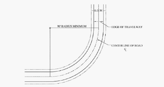
Data Centers. A facility of 4,000 square feet or greater, containing a grouping of computer servers and associated equipment and systems used for the remote storage, processing, or distribution of data, for purposes other than cryptocurrency mining operations. Data Centers less than 4,000 square feet cumulative total of all buildings shall be regulated as manufacturing and processing operations.
Deciduous. A plant with foliage that is shed annually.
Design Manual, Erosion and Sedimentation Control. The County adopted manual that provides comprehensive guidelines and practices for controlling erosion and sedimentation. Unless a manual is adopted by the County, the State manual shall serve as the Design Manual.
Design Professional. A civil engineer or landscape architect who prepares the Erosion and Sediment Control Plan for the person or agent engaged in land-disturbing activity.
Determination. A development regulation enacted under the authority of this Chapter may designate the staff member or members charged with making determinations under the development regulation as defined in G.S. 160D-403.
Department. (Soil Erosion and Sedimentation Control) The North Carolina Department of Environmental Quality.
Development (Flood Damage Prevention). Any man-made change to improved or unimproved real estate, including but not limited to, structures, mining, dredging, filling, grading, paving, excavating operations, drilling operations, or storage of equipment or materials.
Development (Water Quality). A land-disturbing activity which adds to or changes the amount of impervious or partially impervious cover on a land area or which otherwise decreases the infiltration of precipitation into the soil.
Development, Agriculture. A development where the use is agriculture, including agritourism farms and bona fide farms as defined in G.S. 160D-903.
Development, Commercial/Office/Institutional. A nonresidential development that is not industrial.
Development, Existing. Those developments that, at a minimum, have established a vested right under North Carolina zoning law.
Development, Industrial. A nonresidential development that requires a National Pollutant Discharge Elimination System (NPDES) permit for an industrial discharge and/or requires the use or storage of any hazardous material for the purpose of manufacturing, assembling, finishing, cleaning or developing any product or commodity.
Development, Multiphase. All development containing 100 acres or more that is submitted for site plan approval for construction to occur in more than one phase and is subject to a master development plan with committed elements, including a requirement to offer land for public use as a condition of its master development plan approval.
Development, Nonresidential. All development other than residential development and agriculture. Nonresidential development consists of office, institutional, commercial and industrial development.
Development, Residential. Buildings for residential use (including single and multifamily dwellings) and their associated accessory structures and uses.
Development, Single-Tenant. A single establishment, activity or use which does not share any facilities (parking, storage areas, entrances, etc.) with another tenant or use and is developed on an individual parcel.
Development Agreement. An agreement approved by the Board of Commissioners pursuant to the procedures and requirements of NCGS Section 160D-1001 through 160D-1006.
Director. (Soil Erosion and Sedimentation Control) The Director of the Division of Energy Mineral and Land Resources of the Department of Environmental Quality.
Discharge Point or Point of Discharge. (Soil Erosion and Sedimentation Control) Means that point at which stormwater runoff leaves a tract of land where a land-disturbing activity has occurred or enters a lake or natural watercourse.
Disposal (Flood Damage Prevention). The discharge, deposit, injection, dumping, spilling, leaking or placing of any solid waste into or on any land or water so that the solid waste or any constituent part of the solid waste may enter the environment or be emitted into the air or discharged into any waters, including groundwaters (NCGS §130A-290(a)(6)).
Disqualified Party. Any person or entity who has had any county permit suspended, during the period of such suspension.
District. (Soil Erosion and Sedimentation Control) Means the Henderson County Soil and Water Conservation District created pursuant to Chapter 139, North Carolina General Statutes.
Dock/Pier. A water dependent structure; a platform extending from a shore over water and supported by piles or pillars, whose purpose is to secure, protect and provide access to boats.
Dormitory. A facility providing group sleeping accommodations in one (1) or several rooms under joint occupancy and single management, where the use of the facility is associated with an institution or business which provides services, employment or education to people who require temporary housing during the time of their association with the institution or business.
Driveway/Entryway. An area used for ingress or egress of vehicles and allowing access from a traveled way onto a property.
DU. Dwelling unit (See Dwelling Unit).
Dwelling, Accessory. A unit added to, contained within or detached from a principal dwelling unit that provides self-contained, complete and permanent (non-transient) living facilities for one (1) family.
Dwelling, Apartment. (See Accommodation).
Dwelling, Conventional. A dwelling unit constructed in accordance with the standards of the North Carolina State Building Code that is constructed on site.
Dwelling, Duplex. See two family attached dwelling.
Dwelling, Manufactured Home. A dwelling unit constructed in accordance with the Federal Manufactured Housing Construction and Safety Standards Act of 1974 (which became effective June 15, 1976), as amended, and composed of components substantially assembled in a manufacturing plant and transported to the building site for final assembly on a permanent foundation. The term “manufactured home” does not include “mobile home,” “recreational vehicle” or “park model home.”
Dwelling, Mobile Home. A transportable, factory-built home designed for use as a single-family detached residential dwelling and manufactured prior to the Federal Manufacture Housing Construction and Safety Standards Act of 1974 (which became effective June 15, 1976).
Dwelling, Modular. A dwelling unit constructed in accordance with the standards set forth in the North Carolina State Building Code and composed of components substantially assembled in a manufacturing plant and transported to the building site for final assembly on a permanent foundation.
Dwelling, Multifamily. Any building or set of buildings that contain multiple dwelling units intended to house three (3) or more individual families living independent of each other and sharing common walls. Multifamily dwelling does not apply to a single duplex on an individual parcel of land. Multifamily dwellings may be permitted within an approved subdivision that includes single family units/lots. Multifamily dwelling shall not include single-family homes with an attached garage containing only one (1) garage apartment. Multifamily dwelling includes, but is not limited to, apartment, condominium and townhome which may be under a single ownership or the units may be individually owned.
Dwelling, Quadraplex. Four (4) dwelling units, including modular homes, placed one (1) on top of another and/or side-by-side and sharing common walls, floors and/or ceilings.
Dwelling, Single-Family Detached. A single-family dwelling which is located in a separate building detached from any other building (excluding a customary accessory structure). Single-family detached dwellings may include dwellings constructed on site or modular dwellings.
Dwelling, Triplex. Three (3) dwelling units, including modular homes, placed one (1) on top of another or side-by-side and sharing common walls, floors and/or ceilings.
Dwelling, Two Family Attached. Two (2) dwelling units, including modular homes, placed one (1) on top of another or attached side by side and sharing one or more common walls, floors and/or ceilings. This is commonly referred to as a duplex.
Dwelling Unit. A building or portion thereof, providing complete and permanent living facilities for one (1) family.
Easement. That portion of land or property reserved for present or future use by a person or agency other than the legal fee owner(s) of the property. The easement shall be permitted to be for use under, on, or above said lot(s).
Elevated Structure. A non-basement structure which has its reference level raised above ground level by foundation walls, shear walls, posts, piers, pilings or columns.
Encroachment (Flood). The advance or infringement of uses, fill, excavation, structures or development into a floodplain, which may impede or alter the flow capacity of a floodplain.
Energy Dissipator. A structure or a shaped channel section with mechanical armoring placed at the outlet of pipes or conduits to receive and break down the energy from high velocity flow.
Entertainment Complex. An establishment that is conducted exclusively for entertainment. Entertainment complexes include some form of live entertainment and may include food services, beverage services, etc. Accessory structures and uses necessary to the operation of the complex may be included in this definition, as determined by the Zoning Administrator. This definition does not include adult theatres/live entertainment or cinema complexes.
Erosion. The wearing away of land surfaces by the action of wind, water, gravity, or any combination thereof.
Erosion and Sedimentation Control Design Manual. (See Design Manual, Erosion and Sedimentation Control).
Evergreen. A plant with foliage that persists and remains green year-round.
Expressway. Expressways generally feature characteristics of high mobility and moderate to low accessibility. Moving through-traffic is an important element; however, access points are allowed, but limited. Traffic signals are not permitted, but driveway connections are permitted. Typically, roadways in this category have a minimum of four (4) travel lanes, are median-divided facilities, and generally have posted speed limits of 55 to 60 miles per hour.
Extended Care Facility. A licensed care facility that provides continuing services to residents and which shall include: family care homes, hospice residential care facilities, assisted living residences, adult care homes, mental health facilities, multiunit assisted housing with services, nursing homes and continuing care retirement communities.
- Family Care Home. A care home (for persons of any age) having two (2) to six (6) residents (based on NCGS §131D-2(A)(5)). Extended care facilities with two (2) to six (6) residents shall, for the purposes of this Chapter, be included with and permitted in the same fashion as a family care home (see Family Care Home for full definition).
- Hospice Residential Care Facility. A freestanding licensed hospice facility which provides palliative and supportive medical and other health services to meet the physical, psychological, social, spiritual and special needs of terminally ill patients and their families in a group residential setting.
- Assisted Living Residence. A group housing and services program for seven (7) or more unrelated persons, by whatever name it is called, that makes available, at a minimum, one (1) meal a day and housekeeping services and provides personal care services directly or through a formal written agreement with one or more licensed home care or hospice agencies. Extended care facilities with seven (7) or more residents (excluding hospice residential care facilities and nursing homes) shall, for the purposes of this Chapter, be included with and permitted in the same fashion as an assisted living residence (see Assisted Living Residence for full definition).
- Adult Care Home. An assisted living residence in which the housing management provides 24 hour scheduled and unscheduled personal care services to residents, either directly or, for scheduled needs, through formal written agreement with licensed home care or hospice agencies (see Adult Care Home for full definition).
- Mental Health Facilities. A facility that provides services to individuals who are mentally ill, developmentally disabled, or substance abusers for one or more minors or for two (2) or more adults. These services shall be residential services provided for 24 consecutive hours or more. Facilities for individuals who are substance abusers include chemical dependency facilities.
- Multiunit Assisted Housing with Services. An assisted living residence in which hands on personal care services and nursing services (which are arranged by housing management) are provided by a licensed home care or hospice agency, through an individualized written care plan (see Multiunit Assisted Housing with Services for full definition).
- Nursing Home. A facility, however named, which is advertised, announced or maintained for the express or implied purpose of providing nursing or convalescent care of seven (7) or more persons unrelated to the licensee (see Nursing Home for full definition).
- Continuing Care Retirement Community. A continuing care retirement community involves the furnishing to an individual (other than an individual related by blood, marriage or adoption to the person furnishing the care) of lodging together with nursing services, medical services or other health related services, under an agreement effective for the life of the individual or for a period longer than one (1) year (see Continuing Care Retirement Community for full definition).
Fall Zone. The area in which a wireless support structure may be expected to fall in the event of a structural failure, as measured by engineering standards.
Family Care Home. A care home (for persons of any age and which includes, but is not limited to adult care homes, hospice residential care facilities, or nursing homes) having two (2) to six (6) residents (based on NCGS §131D-2(a)(5)).Extended care facilities with two (2) to six (6) residents shall, for the purposes of this Chapter, be included with and permitted in the same fashion as family care homes.
Family Childcare Home (FCCH). Childcare arrangement in the provider's home that may have no more than five (5) preschool children present at any one (1) time. The program may enroll up to eight (8) children if at least three (3) of the children are school aged.
Farm, Agritourism. A working farm or ranch that welcomes visitors who come to purchase agricultural products or value-added agricultural products, learn about or participate in agricultural-themed recreation and/or entertainment, and who pay the farmer a fee for that experience.
Farm, Bona Fide. All land on which agricultural operations are conducted as a principal or accessory use.
FBFM. Flood Boundary and Floodway Map.
FEMA. The Federal Emergency Management Agency of the United States Department of Homeland Security.
Final Plat. A plat representing a lot, parcel, subdivision or a tract of land showing the boundaries and location of individual properties, roads and other information required by this Chapter and NCGS. A final plat shall be prepared by a professional land surveyor, currently licensed and registered in the State of North Carolina, in such a fashion as to be suitable for recording by the Henderson County Register of Deeds and in accord with NCGS §47-30.
Fire Lane. A road or other passageway developed to allow the passage of fire apparatus. A fire lane is not necessarily intended for vehicular traffic other than fire apparatus.
Fire and Rescue Station. A government or quasi-public establishment primarily engaged in fire fighting and other related fire protection activities. Government or quasi-public establishments providing combined fire protection and ambulance or rescue services are classified in this industry.
Fire Protection. The design, construction and installation of buildings and facilities, equipment, appliances and infrastructure or the protection of the facilities and buildings, and the occupants thereof, from the effects or potential effects of fire. All uses requiring fire protection in this Chapter shall be required to comply with the standards of the National Fire Protection Association.
FIRM. Flood Insurance Rate Map.
Flea Market. A place that has regular consistent hours of operation on a regular reoccurring basis of at least four (4) days a month where people buy, auction, rent, sell, appraise, lease or exchange goods, products or services including but not limited to real property, personal property, services, food and/or entertainment whether it indoors, outdoors or a combination venue.
Flood/Flooding. A general and temporary condition of partial or complete inundation of normally dry land areas from: the overflow of inland or tidal waters; and/or the unusual and rapid accumulation of runoff of surface waters from any source.
Flood Fringe. The flood fringe as shown on the Flood Boundary and Floodway Map (FBFM).
Flood Insurance. The insurance coverage provided under the National Flood Insurance Program.
Flood Insurance Rate Map (FIRM). An official map of a community, issued by FEMA, on which both the Special Flood Hazard Areas and the risk premium zones applicable to the community are delineated.
Flood Insurance Study (FIS). An examination, evaluation and determination of flood hazard areas, corresponding water surface elevations (if appropriate), flood insurance risk zones and other flood data in a community issued by FEMA. The Flood Insurance Study report includes Flood Insurance Rate Maps (FIRMs).
Flood Prone Area. (See Floodplain).
Flood Zone. A geographic area shown on a Flood Insurance Rate Map (FIRM) that reflects the severity or type of flooding in the area.
Floodplain. Any land area susceptible to being inundated by water from any source.
Floodplain Development Certificate of Compliance/Occupancy. A certification that the development within the floodplain is in compliance with this Chapter and may be occupied.
Floodplain Management. The operation of an overall program of corrective and preventive measures for reducing flood damage and preserving and enhancing, where possible, natural resources in the floodplain, including but not limited to emergency preparedness plans, flood control works, floodplain management regulations and open space plans.
Floodplain Management Regulations. This Chapter, building codes, health regulations, special purpose ordinances, and other applications of police power. This term describes federal, state, or local regulations in any combination thereof, which provide standards for preventing and reducing flood loss and damage.
Floodproofing. Any combination of structural and nonstructural additions, changes or adjustments to structures, which reduce or eliminate flood damage to real estate, improved real property, water facilities, sanitation facilities, or structures and their contents.
Floodway. The channel of a river or other watercourse and the adjacent land areas that must be reserved in order to discharge the base flood without cumulatively increasing the water surface elevation more than one (1) foot.
Floor. (See Lowest Floor).
Floor Area, Gross. The total floor area of all buildings in a project (including basements, mezzanines and upper floors) and which excludes stairways, elevator shafts and separate service facilities outside the principal building (boiler rooms, maintenance shops, etc.).
Food Manufacturing. An establishment that includes the following: dairy product manufacturing (including milking, cheese manufacturing and butter manufacturing); grain and oilseed milling (including flour milling, malt manufacturing, rice milling, starch and vegetable fats and oils manufacturing, wet corn milling, soybean processing, fats and oils refining and blending and breakfast cereal manufacturing); wine and brandies manufacturing; snack food manufacturing; coffee and tea manufacturing; concentrate, syrup, condiment and spice manufacturing; establishments that freeze food and use preservation processes (pickling, canning and dehydrating); and an entire range of other miscellaneous food product manufacturing.
Footprint. The outside dimensions of a building describing the amount of space it occupies on the ground, usually expressed in square feet.
Forestry. Includes timber tract operations and forest nurseries and gathering of forest products. This subsector specializes in long production cycles that separate it from crop production.
Forestry Support Services. An establishment primarily engaged in performing particular support activities related to timber production, wood technology, forestry, economics, marketing and forest production. These establishments may provide support activities for forestry, such as estimating timber, forest firefighting, forest pest control and consulting on wood attributes and reforestation.
Fraternity and/or Sorority House. A specific type of rooming and boardinghouse, which is for the purposes of housing members and meetings of a fraternal organization. These establishments provide temporary or longer-term accommodations which, for the period of occupancy, may serve as a principal residence. These establishments also may provide complementary services, such as housekeeping, meals and laundry services.
Freeboard. The height added to the Base Flood Elevation (BFE) to account for the many unknown factors that could contribute to flood heights greater than the height calculated for a selected size flood and floodway conditions, such as wave action, blockage of bridge openings, and the hydrological effect of urbanization of the watershed. The Base Flood Elevation (BFE) plus the freeboard establishes the Regulatory Flood Protection Elevation.
Freeway. Freeways generally feature characteristics of high mobility and low accessibility, or full control of access. Carrying through traffic and controlling access points are of supreme importance of roadways classified in this category. Typically, freeways have a minimum of four (4) travel lanes, are median-divided facilities, and generally have posted speed limits of 55 miles per hour or greater. Traffic signals and driveways are not permitted, as access is only permitted at grade-separated interchanges.
Frontage. The side of a lot adjacent to the traveled way. All sides of a lot adjacent to the traveled way shall be considered frontage and have yard provided as indicated under the yard requirements set forth in this Chapter.
Fuel Oil Distribution and Sales. An establishment with bulk liquid storage facilities primarily engaged in wholesaling, retailing and/or distributing fuel oil and fuel oil products.
Full Pond Elevation. The elevation, measured in feet above mean sea level, of the top of a lake’s spillway or the top of the floodgates (if applicable).
Functionally Dependent Facility. A facility which cannot be used for its intended purpose unless it is located in close proximity to water, limited to a docking or port facility necessary for the loading and unloading of cargo or passengers, shipbuilding or ship repair. The term does not include long-term storage, manufacture, sales or service facilities.
Garage, Residential. A building primarily designed to house vehicles, which can be either attached to or detached from the dwelling unit.
Gate and/or Guardhouse. Structures for the purpose of restricting access to all or portions of a property.
Gate, Entry. Movable partition for controlling access and egress (See Chapter 47 of the Henderson County Code, Entry Gates).
Golf Course and/or Country Club. An establishment primarily engaged in operating golf courses (except miniature) and/or dining and other recreational facilities known as country clubs. These establishments often provide food, beverage, equipment rental and golf and recreational instructional services.
Governmental Recreational Facilities. A public recreation facility that is indoors and/or outdoors which may include: courts (basketball, tennis, etc.), swimming pools, batting cages, shuffleboard areas and/or other such uses that fit the intent of this Chapter as determined by the Zoning Administrator. A government recreational facility shall, for purposes of this Chapter, not include go-cart tracks (a recreational motor sports facility), golf courses, miniature golf courses, golf driving tees/ranges.
Greenhouse. An enclosed structure with transparent or translucent roof and/or wall panels, and devoted to the cultivation and protection of plants out of season or climate.
Greenway. A public space that may be a linear park, alterative transportation route and/or open space conservation area that provides passive recreational opportunities, pedestrian and/or bicycle paths and/or the conservation of open spaces or natural areas, which may be so indicated in a greenway plan.
Ground Cover. Any natural vegetative growth or other material which renders the soil surface stable against accelerated erosion.
Hazardous Waste Management Facility. A facility for the collection, storage, processing, treatment, recycling, recovery or disposal of hazardous waste as defined in NCGS Chapter 130A, Article 9.
Height. The height of a building or structure measured as the vertical distance from the finished main floor level to the highest point of the building or structure. Chimneys, cupolas and steeples are not included in measuring a building or structure height.
Heliport (Private Accessory). A facility or structure that is used for the landing and take-off of rotary-wing aircraft, but not including the regular repair, fueling and/or maintenance of such aircraft or the sale of goods/materials to users of such aircraft.
High-Density Project. Any project that exceeds the low-density threshold for dwelling units per acre or built-upon area.
High Quality Waters. Those classified as such in 15A NCAC 2B.0224, which is incorporated by reference. Including subsequent amendments and additions.
High Quality Water (HQW) Zones. For the Coastal Counties, areas within 575 feet of High Quality Waters; and for the remainder of the state, areas within one (1) mile and draining to HQW’s.
Highest Adjacent Grade (HAG). The highest natural elevation of the ground surface prior to construction, immediately next to the proposed walls of the structure.
Historic Structure. A structure that is:
- Listed individually in the National Register of Historic Places (a listing maintained by the US Department of Interior) or preliminarily determined by the Secretary of the Interior as meeting the requirements for individual listing on the National Register;
- Certified or preliminarily determined by the Secretary of Interior as contributing to the historical significance of a registered historic district or a district preliminarily determined by the Secretary of the Interior to qualify as a registered historic district;
- Individually listed on a state inventory of historic landmarks in communities with a “Certified Local Government (CLG) Program”; or
- Certified as contributing to the historical significance of a historic district designed by a community with a “Certified Local Government (CLG) Program”. Certified Local Government (CLG) Programs are approved by the US Department of the Interior in cooperation with the North Carolina Department of Cultural Resources through the State Historic Preservation Officer as having met the requirements of the National historic Preservation Act of 1966 as amended since 1980.
Home Occupation, Adult Day Care. A daycare program for two (2) to six (6) people operated in a single-family detached dwelling (10A NCAC 06R .0201). (See also Home Occupation, General).
Home Occupation, Childcare Facility. A family childcare home with no more than 12 children (where any of the children are preschool-aged or younger) or no more than 15 children (where they are school aged) that provides childcare, regardless of the time of day and whether or not operated for profit (NCGS §110-86(3)).
Home Occupation, General An accessory use of a structure for a limited nonresidential purpose that is clearly incidental and subordinate to the use of the property for residential purposes.
Hospice Residential Care Facility. A freestanding licensed hospice facility which provides palliative and supportive medical and other health services to meet the physical, psychological, social, spiritual and special needs of terminally ill patients and their families in a group residential setting (NCGS §131E-176(13c)).
Impervious Surface. A ground covering which prevents or restricts the absorption of water directly into the ground below (including, but not limited to, structures, roofs, driveways, roads, concrete slabs, walkways, and paved (asphalt, concrete, etc.)/compacted stone parking lots, etc).
Impervious Surface, Maximum. Maximum impervious surface indicates that not more than the percentage of the total land area indicated be covered by impervious surface.
Improvement Guarantee. Cash, letters of credit, trust agreements, bonds or similar financial instruments deposited with the County to assure that required improvements will be constructed or installed.
Issuing Party. The Henderson County Department or employee who originally granted the permit to the disqualified party.
Junk. Litter; debris; animal carcasses; used or unserviceable motor vehicle and machinery parts; used and non-functional furniture, appliances, tools, equipment and implements; and waste materials of any kind (excluding compost piles for normal, personal or noncommercial uses, in their proper location).
Junkyard. A parcel having a principal use consisting of the storing, keeping, buying or selling of junk, as defined herein. This definition excludes any vehicle graveyard or manufactured/mobile home graveyard.
Junked Motor Vehicle. A motor vehicle which does not display a current license plate or vehicle registration.
Kennel. A collection of structures, property, outside/outdoor uses of land in which domestic animals are housed, maintained and/or bred. (See Chapter 16 of the Henderson County Code, Animal).
Lake or Natural Watercourse. Any stream, river, brook, swamp, sound, bay, creek, run, branch, canal, waterway, estuary, and any reservoir, lake or pond.
Land Clearing Debris and Inert Debris Storage or Disposal. A disposal facility which stores solid waste resulting solely from land-clearing activities (stumps, trees, bricks, concrete, etc.).
Land-Disturbing Activity. Any use of the land by any person in residential, industrial, education, institutional, or commercial development, highway and road construction and maintenance that results in a change in the natural cover or topography and that may cause or contribute to sedimentation.
Landfill. A facility for the disposal of solid waste on land in a sanitary manner in accordance with NCGS Chapter 130A, Article 9. For the purpose of this Chapter, this term does not include composting facilities.
Landfill, Nondischarging. A landfill which does not discharge treated leachate into surface waters and for which no National Pollutant Discharge Elimination System (NPDES) permit is required.
Landscaping Materials Sales and Storage. An establishment primarily engaged in selling and storing a variety of landscaping materials including but not limited to plants, shrubs, trees, mulch, timbers, rocks, etc. directly associated with or used for landscaping.
Larger Common Plan of Development or Sale. Any area where multiple separate and distinct construction or land-disturbing activities will occur under one (1) plan. A plan is any announcement or piece of documentation (including but not limited to a sign, public notice or hearing, sales pitch, advertisement, loan application, drawing, permit application, zoning request, or computer design) or physical demarcation (including but not limited to boundary signs, lot stakes, or surveyor markings) indicating that construction activities may occur on a specific plot.
Law Enforcement Establishment. A government establishment primarily engaged in criminal and civil law enforcement, police, traffic safety and other activities related to the enforcement of the law and preservation of order. Combined police and fire departments are included in this industry.
Library/Archive. These establishments are engaged in maintaining collections of documents (books, journals, newspapers and music) and facilitating the use of such documents as are required to meet informational, research, educational or recreational needs of their user(s). These establishments may also acquire, research, store, preserve and generally make accessible to the public historical documents, photographs, maps, audio material, audiovisual material and other archival material of historical interest. All or portions of these collections may be accessible electronically.
Lighting, Adequate. Lighting of areas used for vehicular and pedestrian access which serves to heighten visibility and, as a result, protect the public health, safety and welfare.
Lighting Mitigation. Mitigating the impact of outdoor lighting fixtures in order to protect neighboring properties and roads from direct glare or hazardous interference of any kind. Lighting mitigation typically involves directing lighting fixtures away from adjacent properties but may also include the installation of planted buffers, screens, walls, etc.
Local Government (Soil Erosion and Sedimentation Control). Any county, incorporated village, town or city, or any combination of counties, incorporated villages, towns, and cities, acting through a joint program pursuant to the provisions of the Act and all rules and orders adopted pursuant thereto.
Local Road. Local roads generally are designed to provide final access to properties, rather than through movements. There is no control of access (i.e. no physical restrictions on access). Traffic signals are allowed, at a recommended minimum spacing of one-quarter (¼) mile. Driveways are allowed with full movement, but are still recommended to be consolidated or shared if possible. Roadways in this category will have neither a center left turn lane nor a median. Speed limits are generally regulated at 35 miles per hour or less.
Lot. A parcel of land occupied or capable of being occupied by a structure or group of structures devoted to a common use, together with the customary accessory structures/uses and open spaces belonging to the same.
Lot, Double-Fronted. A lot abutting two (2) traveled ways.
Lot, Existing. (See Lot of Record)
Lot, Flag. An irregularly shaped lot where the buildable portion of the lot is connected to a road by a narrow extension of the lot.
Lot, Auxilliary. Lots clearly identified and restricted for a designated use (placement of a sign, common area(s), recreation area(s), water tank, pump station, etc.), not intended for sale, and clearly identified as such on development plans and final plats.
Lot, Zoning. A parcel of land that is designated by its owner/developer at the time of applying for a building permit as one (1) lot, all of which is to be used, developed or built-upon as a unit under single ownership. Such lot may consist of a: single lot of record; portion of a lot of record; combination of complete lots of record; combination of complete lots and portions of lots of record; or combination of portions of lots of record.
Lot Area. The amount of horizontal land area contained inside the lot lines of a lot or site.
Lot Line, Front. The line of a lot separating a lot from the edge of the traveled way.
Lot Line, Rear. The line of a lot which is opposite and farthest from the front lot line.
Lot of Record. A lot which is part of a subdivision, a plat of which has been recorded in the Register of Deeds Office of Henderson County prior to the adoption of this Chapter, or a lot described by metes and bounds, the description of which has been so recorded prior to the adoption of this Chapter.
Lot Size. The total horizontal area within the lines of a lot, exclusive of road or highway rights-of-way, measured in acres.
Low-Density Project. Any project that falls within the low-density threshold for dwelling units per acre or built-upon area.
Lowest Adjacent Grade. The elevation of the ground, sidewalk or patio slab immediately next to the structure, or deck support, after completion of the structure.
Lowest Floor. The lowest floor (subfloor, top of slab or grade) of the lowest enclosed area (including basement). An unfinished or flood resistant enclosure, usable solely for parking of vehicles, building access or limited storage in an area other than a basement area is not considered a building’s lowest floor provided that such an enclosure is not built so as to render the structure in violation of the applicable non-elevation design requirements of this Chapter.
Machining and Assembly Operations. An establishment engaged in the assembly, fabrication and/or modification of products utilizing specialized equipment to produce non-perishable goods generally created from alloys, plastics or other compounds. Machining and assembly operations differ from manufacturing and production operations as they do not create objects from raw materials; rather, they modify previously assembled parts, fabricate objects from finished materials (e.g. metal and plastic blanks) and/or assemble objects from pre-manufactured components.
Mailed Notice of Intent. A mailed notice which is required for communication facilities category three (3). Mailed notices of intent for communication facilities category three (3) shall include: (1) a vicinity map showing proposed communication facility location; (2) a sketch of the communication facility with dimensions which indicate any proposed tower type and height; and (3) a statement from the Communication Facilities Administrator indicating the processes and procedures by which the communication facility may be permitted.
Manufactured Home. (See Dwelling, Manufactured Home).
Manufactured Home Park. A tract of land designed to accommodate three (3) or more manufactured/mobile home spaces, three (3) or more manufactured/mobile homes or any combination of such for rent or lease.
Manufactured Home Park Administrator. (See Administrator, Manufactured Home Park).
Manufactured Home Park Completion of Improvements Permit. A permit issued by the Manufactured Home Park Administrator to an applicant upon completion of improvements indicated in the manufactured home park construction permit, which certifies the manufactured home park conforms to the requirements of this Chapter. A completion of improvements permit is required in order to obtain manufactured/mobile home set-up permits or other building permits from the Henderson County Code Enforcement Services Department.
Manufactured Home Park Construction Permit. A permit issued by the Manufactured Home Park Administrator to an applicant upon approval of a manufactured home park application and site plan which certifies the applicant may begin improvements to the manufactured home park or phase thereof.
Manufactured Home Park/Manufactured Home Subdivision, Existing. A manufactured home park or manufactured home subdivision for which the construction of facilities for servicing the lots on which the manufactured homes are to be affixed (including, at a minimum, the installation of utilities, the construction of roads and either final site grading or the pouring of concrete pads) was completed before the initial effective date of the floodplain management regulations adopted by the community (July 5, 2005).
Manufactured Home Park Operator. The person responsible for the operation of a manufactured home park.
Manufactured Home Park Space. An area of land within a manufactured home park designed for the exclusive use of one (1) manufactured/mobile home and associated accessory structures. A space shall be defined on the ground by the presence of two (2) or more of the following: (1) a water supply system service connection; (2) a wastewater disposal system service connection; and/or (3) electrical service equipment.
Manufactured Home Park Space, Preexisting. A manufactured home space within a manufactured home park which contains an occupied manufactured/mobile home or is defined on the ground by the presence of two (2) of the following: (1) a water supply system service connection; (2) a sewage disposal system connection; or (3) electric service equipment.
Manufactured/Mobile Home Graveyard. A parcel of land having an accessory use consisting of the storage or keeping of three (3) or more wrecked, dismantled, scrapped, ruined or dilapidated manufactured/mobile homes, recreational vehicles or park model homes, which are not occupied by humans.
Manufacturing and Production Operations. An establishment engaged in the mechanical, physical or chemical transformation of raw materials, substances or components into new products. Manufacturing and production operations are often described as plants, factories or mills and characteristically use power-driven machines and materials-handling equipment. Establishments that transform materials or substances into new products by hand may also be included in this sector. Manufacturing establishments may process materials or may contract with other establishments to process their materials for them. Both types of establishments are included in manufacturing. Almost all manufacturing and production operations have some captive research and development or administrative operations, such as accounting, payroll or management.
Map Amendment. (See Amendment, Map).
Market Value. The structure value, excluding the land value and that of any accessory structures or other improvements to the lot (as agreed to between a willing buyer and seller), as established by what the local real estate market will bear. Market value can be established by independent certified appraisal, replacement cost depreciated by age of structure (actual cash value) or adjusted assessed values.
Materials Recovery Facilities (Recycling). An establishment primarily engaged in (1) operating facilities for separating and sorting recyclable materials from non-hazardous waste streams (i.e., garbage (all putrescible wastes, including animal offal and carcasses, and recognizable industrial byproducts, but excluding sewage and human waste)) and/or (2) operating facilities where co-mingled recyclable materials, such as paper, plastics, used beverage cans and metals are sorted into distinct categories.
Mean Sea Level. The National Geodetic Vertical Datum (NGVD) as corrected in 1929, the North American Vertical Datum (NAVD) as corrected in 1988 or other vertical control datum used as a reference for establishing varying elevations within the floodplain, to which Base Flood Elevations (BFEs) shown on a FIRM are referenced. Refer to each FIRM panel to determine datum used.
Mental Health Facilities. A facility that provides services to individuals who are mentally ill, developmentally disabled, or substance abusers for one or more minors or for two (2) or more adults. These services shall be residential services provided for 24 consecutive hours or more. Facilities for individuals who are substance abusers include chemical dependency facilities (based on NCGS §122C-3.(14)b.)).
MHP. Manufactured Home Park. (See Manufactured Home Park).
Mining and Extraction Operations. An establishment primarily engaged in mining, mine site development and beneficiating (i.e. preparing) metallic and nonmetallic minerals, including coal. This includes ore extraction, quarrying and beneficiating (e.g. crushing, screening, washing, sizing, concentrating and floating customarily done at the mine site), storage of mining overburden, conversion of aggregates to concrete or hot mix asphalt on property within or on industrially zoned parcels immediately adjacent to the State Mine Permit Boundary, and the production and storage of recycled concrete or asphalt pavement for conversion to finished product.
Model Home/Sales Office, Temporary. A structure used on a temporary basis for the purposes of generating sales within a residential development.
Motor Sports Facility. A facility, track or course upon which motor sports racing or racing practice is conducted.
Motor Sports Facility, Major. A motor sports facility having a seating or standing capacity of 500 or more patrons/spectators. Standing capacity (for the purposes of this definition) shall be computed based on three (3) persons for each 200 square feet of space intended for spectator use.
Motor Sports Facility, Minor. A motor sports facility having a seating or standing capacity of less than 500 patrons/spectators and not considered to be a recreational motor sports facility. Standing capacity shall be computed based on three (3) persons for each 200 square feet of space intended for spectator use.
Motor Sports Facility, Recreational. A motor sports facility designed and operated primarily for racing practice purposes. Recreational motor sports facilities do not provide: seating, cover, concessions or restrooms for spectators/patrons and shall have a capacity of less than 100 spectators and/or riders.
Motor Vehicle. A vehicle which is or is designed to be self-propelled and/or is designed or used for transporting persons or property. This definition includes watercraft but excludes aircraft.
Multi-Tenant Development. A development in which there exists a number of individual and/or separate activities and in which there are shared facilities (such as parking areas or pedestrian mall areas) (example: Shopping Malls, etc.).
Multiunit Assisted Housing with Services. An assisted living residence in which hands-on personal care services and nursing services (which are arranged by housing management) are provided by a licensed home care or hospice agency, through an individualized written care plan. The housing management has a financial interest or financial affiliation or formal written agreement which makes personal care services accessible and available through at least one (1) licensed home care or hospice agency. The resident has a choice of any provider, and the housing management may not combine charges for housing and personal care services. All residents or their compensatory agents, must be capable, through informed consent, of entering into a contract and must not be in need of 24 hour supervision. Assistance with self-administration of medications may be provided by appropriately trained staff when delegated by a licensed nurse according to the home care agency's established plan of care. Multiunit assisted housing with services programs are required to register with the Division of Facility Services and to provide a disclosure statement. The disclosure statement is required to be a part of the annual rental contract that includes a description of the following requirements: emergency response system; charges for services offered; limitations of tenancy; limitations of services; resident responsibilities; financial/legal relationship between housing management and home care or hospice agencies; listing of all home care or hospice agencies and other community services in the area; an appeals process; and procedures for required initial and annual resident screening and referrals for services. Continuing care retirement communities are exempt from the regulatory requirements for multiunit assisted housing with services programs (NCGS §131D-2(7a)).
Natural Drainage and Filtering System. A drainage and filtering system which uses, in lieu of a curb and gutter system, vegetated ditches, grassed swales and/or other natural areas to carry and absorb stormwater runoff from roads, parking lots, buildings and other impervious surfaces where such runoff is not bypassed by gutters, drains, pipes, paved swales or other similar conduits. The purpose of a natural drainage and filtering system is to remove pollutants from stormwater runoff and to allow some ground absorption of the water prior to discharge into streams, rivers, lakes or other surface waters.
Natural Erosion. The wearing away of the earth’s surface by water, wind, or other natural agents under natural environmental conditions undisturbed by man.
NCAC. North Carolina Administrative Code.
NCDENR. North Carolina Department of Environmental and Natural Resources.
NCDOT. North Carolina Department of Transportation.
NCEMC. North Carolina Environmental Management Commission.
NCGS. North Carolina General Statutes.
Neighborhood. An area impacted by a principal use.
New Construction. Structures for which the “start of construction” commenced on or after the effective date of the initial floodplain management regulations (July 5, 2005) and includes any subsequent improvements to such structures.
NFIP. National Flood Insurance Program.
Non-Encroachment Area. The channel of a river or other watercourse and the adjacent land areas that must be reserved in order to discharge the base flood without cumulatively increasing the water surface elevation more than one (1) foot as designated in the Flood Insurance Study report.
Nonconforming. That which was lawfully created prior to the effective date of this Chapter or any portion thereof incorporated into this Chapter, or any amendment thereto, but which does not conform to one or more of the requirements of the Chapter. That which may be nonconforming includes the following:
- Nonconforming lot;
- Nonconforming lot of record;
- Nonconforming manufactured home park (also referred to as pre-existing manufactured home park);
- Nonconforming outside/outdoor use;
- Nonconforming structure;
- Nonconforming structure containing nonconforming use; and
- Nonconforming
Nonconforming Structure or Development (Flood Damage Prevention). Any legally existing structure or development which fails to comply with the current flood damage prevention provisions of this Chapter.
NPDES. National Pollutant Discharge Elimination System.
Nursing Home. A facility, however named, which is advertised, announced or maintained for the express or implied purpose of providing nursing or convalescent care for seven (7) or more persons unrelated to the licensee. A nursing home is a home for chronic or convalescent patients, who, on admission, are not as a rule, acutely ill and who do not usually require special facilities such as an operating room, X-ray, laboratory and obstetrical facilities. A nursing home provides care for persons who have remedial ailments or other ailments, for which medical and nursing care are indicated; who, however, are not sick enough to require general hospital care. Nursing care is their primary need, but they will require continuing medical supervision (NCGS §131E-101(6)). Nursing homes offering one or more levels of care, including any combination of skilled nursing, intermediate care and adult care home (commonly referred to as “combination homes”) shall be included with and regulated in the same fashion as a nursing home (NCGS §131E-101(1a)).
Obstruction (Flood Damage Prevention). Includes, but is not limited to, any dam, wall, wharf, embankment, levee, dike, pile, abutment, protection, excavation, channelization, bridge, conduit, culvert, building, wire, fence, rock, gravel, refuse, fill, structure, vegetation or other material in, along, across or projecting into any watercourse which may alter, impede, retard or change the direction and/or velocity of the flow of water, or due to its location, increase its propensity to snare or collect debris carried by the flow of water, or its likelihood of being carried downstream.
Occupied Building. (See Building, Occupied).
One-Year, 24-Hour Storm. The surface runoff resulting from a 24-hour rainfall of an intensity expected to be equaled or exceeded, on average, once in 12 months and with a duration of 24 hours.
Opaque. That which does not allow light to pass through.
Open Air Market. A market which is open to the outdoors throughout the year. Such a market may be conducted with or without a structure, however where a structure is erected such structure shall be built so as to be “open,” that is, no walls may be constructed which would be more than 25 percent closed.
Open Space. An area that is intended to provide light and air, and is designed for either environmental, scenic or recreational purposes. The term "open space" shall include greenways dedicated for environmental, scenic or recreational purposes. The term “open space” shall not include roads or any areas dedicated or reserved for a road. Those areas which shall not be considered open space include: land within setbacks/separation areas, internal/external roads/rights-of-way, driveways, parking spaces, common area recreation and service facilities, sale/model homes, solid waste disposal areas, and areas needed for aboveground utility facilities including water supply or sewage disposal systems.
Outside/Outdoor Use. A land use activity where the only buildings associated with such activities are incidental and accessory to the principal use. Land uses such as storage yards, used car lots, auto wrecking, salvage yards, golf driving ranges, miniature golf courses, and agriculture are examples of outside/outdoor uses.
Outdoor Sale Display Area. An area reserved for the display of merchandise outdoors and associated with a principal use and/or structure.
Outdoor Storage. The keeping and/or storing of goods, products, supplies or equipment associated with a nonresidential use which is not in an enclosed building, nor in a portable storage container.
Overburden. The earth, rock, and other materials that lie above or in the natural deposit of materials to be mined.
Overlay District. A zone established through this Chapter which regulates the use of land beyond and in addition to those regulations of the underlying use district.
Owner. The legal or beneficial owner of land, including but not limited to a mortgagee or vendee in possession, receiver, executor, trustee, or long-term or commercial lessee, or any other person or entity holding proprietary rights in the property or having legal power of management and control of the property. This shall include long-term commercial tenants; management entities, such as those charged with or engaged in the management of properties for profit; and every person or entity having joint ownership of the property. A secured lender not in possession of the property does not constitute an owner, unless the secured lender is included within the meaning of owner under another description herein, such as a management entity.
PA. Protected Area (See Protected Area).
Packaging and Labeling Services. An establishment primarily engaged in packaging client owned materials. The services may include labeling and/or imprinting the package.
Parent. An affiliate that directly, or indirectly through one or more intermediaries, controls another person.
Park. Those areas developed for both passive and active recreational activities. The development may include, but shall not be limited to, walkways, benches, open fields, multiuse courts, swimming pools, wading pools, amphitheaters, etc. The term “park” shall not include zoos, recreational vehicle parks, manufactured home parks, amusement parks, equestrian racing facilities or dog racing facilities.
Park Model Home. A recreational vehicle which is: (1) built on a single chassis; (2) 400 square feet or less when measured at the largest horizontal projection; (3) self-propelled or permanently towable by a light duty truck; and (4) designed for temporary living quarters for recreation, camping, travel and seasonal use (but in no case for use as a permanent dwelling).
Perimeter Setback. (See Setback, Perimeter).
Person. Any individual, partnership, firm, association, joint venture, public or private corporation, trust, estate, commission, board, public or private institution, utility, cooperative, interstate body, or other legal entity.
Person Conducting Land-Disturbing Activity. Any person who may be held responsible for violation unless expressly provided otherwise by this Chapter, the Act, or any order adopted pursuant to this Chapter or Act.
Person Who Violates or Violator. As used in G.S. 113A-64, means: "any landowner or other Person who has financial or operational control over the land-disturbing activity; or who has directly or indirectly allowed the activity, and who has failed to comply with any provision of the Act, the rules of this Chapter or any order or local ordinance adopted pursuant to the Act as it imposes a duty upon that Person.
Phase. A portion of a development delineated on a development plan/site plan.
Phase of Grading. One (1) of two (2) types of grading: rough or fine.
PIN. (Property Identification Number).
Place of Assembly. A structure or area designed and designated to accommodate persons for the purposes of assembly.
Plan. (Soil Erosion and Sedimentation Control) An erosion and sedimentation control plan.
Planned Seasonal Agricultural Worker Development. A residential use of property for the purpose of seasonally housing workers hired to provide assistance in agricultural operations.
Planning Board. The Planning Board of Henderson County, North Carolina.
Planning Director. The Planning Director for Henderson County, or his/her designee, appointed and authorized to administer this Chapter. Any act authorized by this Chapter to be carried out by the Planning Director is, by implication, authorized to be carried out by a designee of the Planning Director.
Plat. A map showing planned or actual features of an area. A plat may depict a subdivision of land, designation of right-of-way, or other feature to be recorded into public record.
Portable Storage Container. A movable storage container, such as but not limited to “PODS,” which is placed temporarily.
Post-FIRM. Construction or other development for which the “start of construction” occurred on or after January 1, 1975 or on or after the effective date (March 1, 1982) of the initial FIRM for the area, whichever is later.
Pre-FIRM. Construction or other development for which the “start of construction” occurred before January 1, 1975 or before the effective date (March 1, 1982) of the initial FIRM for the area, whichever is later.
Principally Above Ground. At least 51 percent of the actual cash value of the structure is above ground.
Produce Stand. An establishment primarily engaged in retailing fresh fruits and vegetables where other ancillary items may be sold provided that the ancillary items constitute no more than: (1) 25 percent of gross sales, and (2) 25 percent of total display areas.
Product Processing and Storage Facilities. An establishment engaged in the intermediate steps of processing (e.g. packaging, removal of packaging, refrigeration, freezing, modification, etc.) and storage of goods subsequent to production and prior to shipment, sale or use. Product processing and storage facilities do not include operations dealing with hazardous substances or waste.
Protected Area. The area adjoining and upstream of the critical area of WS-IV watersheds. The boundaries of the protected area are defined as: (1) within five (5) miles of and draining to the normal pool elevation of a reservoir or to the ridgeline of the watershed; or (2) within ten (10) miles upstream and draining to the intake located directly in the stream or river or to the ridgeline of the watershed.
Protected Mountain Ridge. A ridge with an elevation of 500 feet or more above the elevation of an adjacent valley floor.
Public Nuisance. (See Public Safety).
Public Safety. Anything which is injurious to the safety or health of an entire community or neighborhood, or any considerable number of persons; this includes that which unlawfully obstructs the free passage or use, in the customary manner, of any navigable lake, river, bay, stream, canal or basin.
Rail Transportation Facilities and Support Activities. An establishment primarily engaged in operating rail systems over regular routes on a regular schedule.
Recombination (Subdivision). The combining of previously subdivided and recorded lots or portions thereof where the total number of lots is not increased and the resulting lots meet the requirements of this Chapter.
Recreational Facilities (Indoor/Outdoor). A recreational facility that is outdoors and/or indoors and which may include: public or private operations, playing fields (soccer, baseball, etc.), courts (basketball, tennis, etc.), swimming pools, batting cages, shuffleboard areas, bowling alley, skating rink, bingo games, miniature race tracks (remote control only) and/or other such uses that fit the intent of this Chapter as determined by the Zoning Administrator. A recreational facility shall, for purpose of this Chapter, not include go-cart tracks (a recreational motor sports facility), golf courses, miniature golf courses, driving tees or driving ranges.
Recreational Vehicle (RV). A vehicular-type unit primarily designed as a temporary and mobile living quarters for recreational, camping or travel use, which either has its own mode of power or is mounted on and drawn by another vehicle. Such units do not satisfy the dimensional requirements of a manufactured home.
Recreational Vehicle (RV) (Flood Damage Prevention). A vehicular-type unit primarily designed as a temporary and mobile living quarters for recreational, camping or travel use, which either has its own mode of power or is mounted on and drawn by another vehicle. Such units do not satisfy the dimensional requirements of a manufactured home. A vehicle which is: (1) built on a single chassis; (2) 400 square feet or less when measured at the largest horizontal projection; (3) designed to be self-propelled or permanently towable by a light duty truck; and (4) designed primarily not for use as a permanent dwelling, but as temporary living quarters for recreational, camping, travel or seasonal use.
Recreational Vehicle (RV) Park. An establishment primarily engaged in operating sites to accommodate park model homes or recreational vehicles. These establishments may provide access to facilities, such as laundry rooms, recreational halls, playgrounds, stores and snack bars. An RV park will generally contain three (3) or more park model homes or recreational vehicles.
Recycling Centers, Drop-off. An establishment primarily engaged in receiving recyclable materials via drop-off.
Reference Level. The top of the lowest floor for structures within Special Flood Hazard Areas designed as Zone A1, A30, AE, A, A99 or AO. The portion of a structure or other development that must be compared to the regulatory flood protection elevation to determine regulatory compliance of such structure.
Redevelopment. Any development on previously-developed land, other than a rebuilding activity that results in no net increase in built-upon area and provides equal or greater stormwater control than the previous development.
Regulatory Flood Protection Elevation. The Base Flood Elevation plus the Freeboard. The elevation to which all structures and other development located within the Special Flood Hazard Areas must be elevated or floodproofed. In Special Flood Hazard Areas where Base Flood Elevations (BFE’s) have been determined, this elevation shall be the BFE plus two (2) feet of freeboard. In areas where no BFE has been established, all structures and other development must be elevated or floodproofed to two (2) feet above the highest adjacent grade or BFE whichever is greater.
Related Parties. Any person, with respect to any disqualified party, who:
- Is the spouse, sibling, parent or child of the disqualified party, or of any other related party.
- Is the employee of the disqualified party.
- Is the managing party, manager, director or owner of at least ten (10) percent of the ownership interest of the disqualified party (whether such disqualified party is a partnership, unincorporated association, corporation, limited liability company, or other entity).
- Exercises the controlling interest in the disqualified party.
- Is the administrator, executor, trustee or other fiduciary of the disqualified party.
- Is controlled by the same entity or entities as the disqualified party.
Religious Institution. A structure and parcel on which it is located, in and on which persons regularly assemble for religious worship. This term includes all facilities which are on all or part of the premises and their associated uses which are: (1) traditionally operated or conducted by a congregation in furtherance of its mission, and/or (2) actually being operated or conducted by the congregation in furtherance of its mission (as permitted in the district in which it is located).
Remedy a Violation. To bring the structure or other development into compliance with state or Henderson County floodplain management regulations, or, if this is not possible, to reduce the impacts of its noncompliance. Ways that impacts may be reduced include protecting the structure or other affected development from flood damages, implementing the enforcement provisions of the Chapter or otherwise deterring future similar violations, or reducing Federal financial exposure with regard to the structure or other development.
Repetitive Loss. Flood-related damages sustained by a structure on two (2) separate occasions during any ten (10) year period for which the cost of repairs at the time of each such flood event, on the average, equals or exceeds 25 percent of the market value of the structure before the damage occurred.
Research and Development Operations (Hazardous or Biological Materials). An establishment primarily involved in research and development operations dealing directly with hazardous materials.
Research and Development Operations (Nonhazardous). An establishment primarily involved in research and development operations excluding hazardous materials.
Residential Density. The number of dwelling units permitted per acre of land.
Residential Zoning District. Zoning districts which include Residential District One (R1), Residential District Two (R2), Residential District Two Rural (R2R), Residential District Three (R3), Residential District Four (R4), Estate Residential Zoning District (R-40), Waterfront Residential District (WR), Surface Water District (SW), and Conditional District (CD).
Residuals. A solid or semisolid waste generated from a wastewater treatment plant, water treatment plant or air-pollution control facility permitted under the authority of the North Carolina Environmental Management Commission.
Retrofitting. Measures, such as floodproofing, elevation, construction of small levees and other modifications, taken on an existing building or its yard to protect it from flood damage or to manage stormwater runoff.
Right-of-Way. An easement, either public or private, on which an irrevocable right-of-passage has been recorded for use as a road, crosswalk, railroad, electric transmission line, oil/gas pipeline, water main, sanitary/storm sewer main, shade trees or other specified use.
Riparian. Of, on, or relating to the banks of a natural course/body of water; including the area of land adjacent to the course/body of water and the vegetation it contains.
Riverine. Relating to, formed by or resembling a river (including tributaries), stream, brook, etc.
Road. A right-of-way for vehicular traffic which affords the principal means of access to abutting properties.
Road, External. A road located outside of a development that abuts the development.
Road, Internal. A road located within a development.
Road, Private Subdivision Collector. A road or a section of a road which:
- Provides direct or indirect access from the entrance of the subdivision inward to 50 or more existing or proposed dwelling units and is designed to be the main travel path for such residential access. The terminus or "last block" of a residential collector road ending in a dead end may be designed to the standards of a private subdivision local road as long as such "last block" serves fewer than 50 dwelling units;
- Is designed/has the potential to serve in a future phase, property in the same ownership of the applicant that, if developed, will meet the 50 dwelling unit standard;
- Connects proposed developments with existing developments where the aggregate sum of dwelling units in both developments is 50 or more;
- Serves as a through-road connecting lots within a residential subdivision to more than one (1) public thoroughfare; and/or
- Serves a nonresidential facility located within a residential development, such as a frequently used recreation area, clubhouse, golf course, public utility site, etc.
Road, Private Subdivision Limited Local. A road or group of roads which serves less than 50 existing or proposed dwelling units and does not connect public roads.
Road, Private Subdivision Local. A road which serves no more than four (4) residential lots each containing or to contain no more than one (1) existing or proposed principal dwelling unit and its associated driveway which does not connect multiple public roads. Limited local road standards shall also apply to roadways proposed solely for maintenance and/or emergency access purposes regardless of the number of lots it adjoins. Emergency access roads shall not be used to access lots within the subdivision and appropriate signage shall be required. Roads proposed for such purposes should be clearly identified on all plans and final plats.
Road, Public. A road which is state-maintained.
Road, Single-Loaded. A road serving property (front yard or side yard) on one (1) side only, with no need for access (to a rear yard or to open space) or parking on this other side.
Road Classification. Roads within the County shall be classified according to the following:
- Local Road. Local roads are generally designed to provide final access to properties, rather than through movements (see Local Road for full definition).
- Collector Road. Collector roads generally feature characteristics of moderate to low mobility and high accessibility, and serve as a link between through-roads and local roads (see Collector Road for full definition).
- Thoroughfare. Thoroughfares generally feature characteristics of moderate to low mobility and high accessibility (see Thoroughfare for full definition).
- Boulevard. Boulevards generally consists of moderate mobility and low to moderate accessibility (see Boulevard for full definition).
- Expressway. Expressways generally feature characteristics of high mobility and moderate to low accessibility (see Expressway for full definition).
- Freeway. Freeways generally feature characteristics of high mobility and low accessibility, or full control of access (see Freeway for full definition).
Road Frontage. Having frontage along a road, as defined herein.
Rooming and Boardinghouse. An establishment primarily engaged in operating rooming and boardinghouses and similar facilities including, but not limited to: cottages, off-campus dormitories, residential clubs and workers’ camps. These establishments provide temporary or longer-term accommodations which, for the period of occupancy, may serve as a principal residence. These establishments also may provide complementary services, such as housekeeping, meals and laundry services.
ROW. Right-of-way (See Right-of-Way).
Rural Family Occupation. An accessory use of a structure for a limited nonresidential purpose that is clearly incidental and subordinate to the use of the property for residential purposes and which is more expansive (in size, number of employees, outside storage area and/or structures) than a home occupation.
S-9.5B Asphalt. Type of asphalt concrete surface which is currently used by NCDOT.
Salvage Yard. A nonresidential property used for the storage, collection and/or recycling of any type of equipment and including but not limited to vehicles, appliances and related machinery.
Sawmill. An establishment primarily engaged in sawing dimension lumber, boards, beams, timbers, poles, ties, shingles, shakes, siding and wood chips from logs or bolts. Sawmills may plane the rough lumber that they make with a planning machine to achieve smoothness and uniformity of size.
School (Home). A nonpublic school as defined and in accordance with NCGS §115C, Article 39, Part 3 (or its successor). Zoning setbacks and separation setbacks requirements do not apply to home schools.
School (Public/Private/Charter). An elementary or secondary school, whether private or public, established under NCGS Chapter 115C (or its successor). Schools include:
- Public School. A school operated under the jurisdiction of the Henderson County Board of Education and supported by tax revenue, or any charter school.
- Private School. A school having a curriculum similar to those of a public school.
- Charter School. A school authorized and operating under NCGS Chapter 115 C, Article 16, Part 6A (or its successor).
School (Technical, Trade and Business). An establishment primarily engaged in offering vocational, technical and business training in a variety of technical and/or business subjects and trades. Business schools are primarily engaged in offering courses in: office procedures, secretarial skills, stenographic skills, and basic office skills (i.e. word processing, office machine operation, reception, communications, and other skills designed for individuals pursuing a clerical or secretarial career). Technical and trade schools offer a variety of courses often leading to job-specific certification.
Screening. A structure or planting that conceals view from public ways or adjacent property.
Section (Phase). A grouping of three (3) or more lots, rights-of-way, common space and associated improvements therein, in a Preliminary Plan, numbered consecutively and relating to stages of a Master Plan.
Sediment. Solid particulate matter, both mineral and organic, that has been or is being transported by water, air, gravity, or ice from its site of origin.
Sedimentation. The process by which sediment resulting from accelerated erosion has been or is being transported off the site of the land-disturbing activity or into a lake or natural watercourse.
Senior Center. A community facility where older adults come together for services and activities that reflect their skills and interests and respond to their diverse needs. Centers are a resource for the entire community, providing services and information on aging, and assisting family and friends who care for older persons. For older persons at risk of losing their self-sufficiency, senior centers are the entry point to an array of services that will help them maintain their independence. Any variety of services to individuals or groups may be accessed depending on local community circumstances. Persons of differing backgrounds share and learn from each other. Persons of all ages with all types of skills and interests are needed to perform vital roles and enhance the services and programs at the centers. (North Carolina Division of Aging and Adult Services).
Setback. The required distance between the location of a structure and/or operation and some other point of location, most typically a lot line, right-of-way or edge of traveled way.
Setback, Front Yard. A setback measured from the property line determined to be the front yard. Where the front yard falls along a road, the setback is to be measured from the edge of the public right-of-way or, where no right-of-way exists, edge of traveled way.
Setback, Perimeter. A setback measured from all lot lines of a parcel. Where the property boundary falls along a road, the setback is to be measured from the edge of the public right-of-way. The perimeter setback shall apply to the use and any structures associated with the use (this shall not include parking, however).
Sewage Disposal System. Any facilities for wastewater (sewage) collection, treatment and disposal which may be of the following types: septic tank sewage disposal system, approved public or community sewage disposal system, or municipal sewage disposal system.
Sewage Disposal System, Municipal. A sewage disposal system that is owned and operated by a local government.
Sewage Disposal System, Approved Public or Community. A sewage disposal system which is a single system of sewage collection, treatment and disposal owned and operated by a sanitary district, metropolitan sewage district, water and sewer authority, county, municipality or public utility constructed and operated in compliance with applicable requirements of the North Carolina Division of Environmental Management.
Sewage Disposal System, Septic Tank. A sewage disposal system which consists of a settling tank and subsurface disposal field.
SFHA. Special Flood Hazard Area (See Special Flood Hazard Area).
Shear Wall. Walls used for structural support but not structurally joined or enclosed at the end (except by breakaway walls). Shear walls are parallel or nearly parallel to the flow of water.
Shooting Range, Commercial. An area, indoors or outdoors, designed and operated for profit for the use of rifles, shotguns, pistols, silhouettes, skeet, trap, black powder, or any other similar sport shooting. This includes any such area owned and/or operated by a for-profit or non-profit entity which requires membership dues to be a member, or which requires any remuneration (including “donations”) in exchange for access to the area, or any other organization that meets the requirements of the exception to the Noise Ordinance in Section 18-4.A.3. For the purpose of this chapter, private shooting that does not meet the above standards for commercial shooting ranges shall be allowed by right without a zoning permit provided that it complies with Chapter 23 of the Henderson County Weapons Ordinance, 23-10.C.
Shopping Mall. A building that contains commercial establishments which have interconnecting and enclosed walkways making it easy for people to walk from establishment to establishment.
Shrub. A woody deciduous or evergreen plant which consists of a number of small branches from or near the ground.
Sight Visibility Triangle. A triangular area formed when connecting new roads to existing state maintained roads, that is measured a distance of 70 feet along the existing road right-of-way and ten (10) feet along the new road right-of-way as defined by State Road Standards (see State Road Standards). The area within the sight visibility triangle shall remain unobstructed between three (3) and ten (10) feet above grade.
Sign. A sign may consist of any of a combination of the following: words, designs, emblems, figures, phrases, trade names, trademarks, devices, lettering, numerals, sentences, parts of letters or parts of numerals. A sign may be made of any material (other than live vegetation) including any surface, fabric or other material background and the structure designed to carry such materials. A sign shall not include: (1) architectural features of a building, even when identifiable with certain establishments; and (2) works of art provided they do not include logos, business names or features that would be advertising the business where the work of art is located. Any art located on a traditional sign shall be considered as part of the sign.
Sign, Agricultural. A sign advertising agricultural products for sale.
Sign, Animated. A sign using flashing or intermittent lights, sound, color changes or other mechanical or electrical means to give motion, the impression of motion/movement or the optical illusion of motion to the sign; or any sign with visible moving, revolving or relocating parts; provided, however, this shall not include time/date/temperature or electronic message signs.
Sign, Area of a. Multiply the vertical distance measured from the highest point to the lowest point on the sign face and the maximum horizontal distance across the sign face.
Sign, Attached. A sign attached to, applied on or supported by any part of a building; including, but not limited to any of the following: wall signs, window signs, signs on canopies, signs on awnings or signs on marquees.
Sign, Awning. A temporary hood or cover which projects from the wall of a building, and which may include a type which can be retracted, folded or collapsed against the face of a supporting building.
Sign, Banner. A flag or other piece of cloth bearing a message that is supported on two (2) vertical or horizontal sides.
Sign, Changeable Copy. A permanently unframed sign, illuminated or not, which is principally devoted to and designed for changeable copy text and graphics, but which specifically excludes time/date/temperature signs and electronic message signs. Changeable copy signs may involve either manual or automatic changeable copy. An automatic changeable copy sign which changes more than two (2) times in a 24 hour period shall be defined to be an electronic message sign. Portable signs are not considered changeable copy signs.
Sign, Commemorative. A sign which denotes, honors, celebrates, acknowledges or is in remembrance of an historical person, place or event.
Sign, Community Identification. A sign erected to identify a specific community, residential subdivision, multifamily housing development or manufactured home park for which boundaries and characteristics have been established and recognized by the Planning Department.
Sign, Construction. A sign whose message is limited to identification of architects, engineers, contractors and other persons involved with the construction project or which may include the name, purpose and expected completion date of the building.
Sign, Copy. Words, letters, numbers, figures, designs or other symbolic representations incorporated into a sign.
Sign, Development Identification. A sign bearing only the name of a multi-tenant development.
Sign, Directional. A sign whose sole purpose is to direct pedestrian or vehicular traffic on the premises on which it is displayed. Examples include: “in,” “out,” “entrance,” “exit” and “driveway.”
Sign, Double-Faced. A sign constructed to display its message on the outer surface of two (2) identical and opposite parallel planes.
Sign, Electronic Message. A sign which displays changeable information and is composed of a series of lights that may be changed automatically through electronic means, including LED displays. All messages shall be visible for a minimum of three (3) seconds and shall not play video. These will not be deemed to constitute changeable copy or animated signs.
Sign, Externally Illuminated. A sign which reflects light from a source intentionally directed upon it from a distance.
Sign, Flag. A flag or other piece of cloth bearing a message that is supported on one (1) vertical side by a pole.
Sign, Flashing. A sign illuminated by direct or indirect artificial light that flashes on and off in regular or irregular sequences, including, but not limited to, strobe light.
Sign, Governmental. A sign erected by or on the order of an authorized public official which includes, but is not limited to, traffic control, road name/identification, warning, directional, public notice or similar signs.
Sign, Ground. A freestanding or monument sign, flush to the ground, and not elevated upon poles/stanchions or attached to a building/structure.
Sign, Home Occupation. A sign identifying a home occupation (general, adult daycare or childcare facility).
Sign, Incidental. A sign attached wholly to a building, window or door containing information relative to emergencies, store hours, credit cards honored and other similar accessory information.
Sign, Inflatable. A sign that is blown up (increased in volume) with air or gas.
Sign, Internally Illuminated. A sign whose light source is located in the interior of the sign so that the rays go through the face of the sign, or where the light source is attached to the face of the sign and is perceived as a design element of the sign.
Sign Height. The vertical distance from the uppermost point used in measuring the area of a sign to the average grade immediately below and adjoining the sign. For outdoor advertising signs, sign height shall be measured from the existing road grade to the uppermost point on the sign structure.
Sign, Marquee. A sign of a theater, auditorium, fairground or museum which advertises current and scheduled events. Marquees may include, incorporate or consist of electronic message signage.
Sign, Menu Board. A freestanding or wall mounted sign primarily designed for the display of menu items and prices for the purpose of placing orders for such items in conjunction with a restaurant utilizing drive-through service. Said signs are considered incidental signs.
Sign, Monument. See ground sign.
Sign, Multi-Faceted. A sign that contains more than one (1) plane in the sign face.
Sign, Multi-Tenant Development. A sign bearing the name of individual tenants located within a multi-tenant development and which may include the name of the multi-tenant development.
Sign, On-Premise. A sign used for the purpose of displaying, advertising, identifying or directing attention to a business, products, operations or services sold or offered on the lot of record where the sign is located.
Sign, Outdoor Advertising. A sign or structure, pictorial or otherwise, that draws attention to or communicates information about a business, profession, service, commodity, product, accommodation, event, attraction or other enterprise or activity that exists or is conducted, manufactured, sold, offered, maintained or provided at a location other than on the premises where the sign or structure is located. Outdoor advertising does not, for the purposes of this Chapter, include billboards.
Sign, Pole. A freestanding sign which is permanently affixed to the ground by a pole or other structure and which is not part of the building. This shall not be considered to include signs on canopies.
Sign, Political. A sign promoting or publicizing a candidate/candidates for election or signs related to issues on a ballot. Such political signs may be erected at any time subsequent to filing for candidacy or the placement of an issue on the ballot.
Sign, Portable. A sign that is not permanently affixed to a structure.
Sign, Property Identification. A sign that contains the property address (road name and house number), homeowner’s name or name of business or other identifying symbol of a building, profession, institution or service conducted on the lot.
Sign, Regulatory. A sign erected for the purposes of traffic control, as regulated by the Manual on Uniform Traffic Control Devices (MUTCD), including warning, safety and railroad signs.
Sign, Roof. An attached sign erected, constructed or maintained on, upon or over the roof of any structure and which is wholly or partially dependent upon the roof for support.
Sign, Sandwich Board. A portable sign which is single- or double-faced, which may readily be moved from place to place, and which is intended to be used on a sidewalk or pedestrian way. These signs are considered temporary in nature.
Sign, Single-Tenant Development. A sign bearing the name of the single tenant of an individual parcel.
Sign, Temporary. A sign with or without a structural frame, not permanently attached to a building, structure or the ground and intended for a limited period of display. Any sign announcing a one (1) time event such as “Grand Opening,” “Sale Saturday” and the like and may include the following: sandwich board signs, wind signs, changeable copy signs, inflatable signs, banners, pennants, streamers and/or posters (excludes portable signs).
Sign, Temporary Event. A sign placed temporarily to direct traffic to special events, festivals, etc.
Sign, Time/Date/Temperature. A sign containing numerals or letters, which may be alternately displayed and which show the time, date and/or temperature. This sign shall not be considered a flashing or an animated sign.
Sign, Vehicle Sale. A sign affixed to the window of a vehicle displaying terms of sale of said vehicle and placed on property where the owner of the vehicle(s) resides.
Sign, Wall. A sign painted/attached flat against, parallel to or projecting from the exterior wall or surface of a structure.
Sign, Wind. A suspended sign made of a flexible material such as canvas, sailcloth, plastic or waterproof paper, including, but not limited to, banners, pennants, spinners or streamers. These signs are considered temporary.
Sign, Window. A sign which is permanently painted on, attached to or designed to be visible through a window (excluding displays of merchandise).
Sign Setback. The setback of a sign is measured from the closest portion of the sign or sign structure to the closest property line on which the sign fronts.
Sign Stanchion. A vertical supporting beam, post, pole or rod.
Sign Structure. A structure which supports, has supported or is capable of supporting a sign, including any decorative cover for said sign structure.
Single-Family Residential Development. A residential development where no building contains more than one (1) dwelling unit.
Siltation. Sediment resulting from accelerated erosion which is settleable or removable by properly designed, constructed, and maintained control measures; and which has been transported from its point of origin within the site of a land-disturbing activity; and which has been deposited, or is in suspension in water.
Site Plan. The site plan shall contain all items required by the County for applicable review. Such plan may include, but not be limited to, the following: (1) the approximate boundaries of the site; (2) significant topographical and other natural features effecting development of the site; (3) proposed vegetation removal and open space preservation; (4) the approximate location on the site of existing and proposed structures, coverage of lot by those structures and other improvements; (5) the approximate dimensions, including height and scale, of the proposed structures (and their relation to surrounding existing and proposed future uses); (6) the approximate locations and dimensions of proposed buffers and landscaping; (7) the proposed location and dimensions of signs; (8) the approximate location of all existing and proposed infrastructure on the site, including stormwater, water, sewer, roads, parking and pedestrian walkways; and (9) any proposed phasing.
Site-Specific Vesting Plan. A plan which has been submitted to the County by a landowner describing with reasonable certainty the type and intensity of use for a specific parcel or parcels of property. Such plan may be in the form of, but not be limited to, any of the following plans or approvals: a preliminary or master development plan, Special Use Permit, or any other land-use approval designation as may be utilized by the County. Such plan shall include: (1) the approximate boundaries of the site; (2) significant topographical and other natural features effecting development of the site; (3) the approximate location on the site of the proposed buildings, structures and other improvements; (4) the approximate dimensions, including height, of the proposed buildings and other structures; and (5) the approximate location of all existing and proposed infrastructure on the site, including water, sewer, roads and pedestrian walkways. A variance shall not constitute a site-specific vesting plan, and approval of a site-specific vesting plan with the condition that a variance be obtained shall not confer a vested right unless and until the necessary variance is obtained. Neither a sketch plan nor any other document which fails to describe with reasonable certainty the type and intensity of use for a specified parcel/parcels or property may constitute a site-specific vesting plan. (See NCGS §160D-102(29)).
Sketch Plan (Soil Erosion and Sedimentation Control). A graphic illustration used to depict proposed land-disturbing activities.
Slope. The level inclination of land from the horizontal plane determined by dividing the horizontal run of the land into the vertical rise of the same land and converting the result into a percentage value. For purposes of measurement, property must be at least 25 feet vertically and 50 feet horizontally. See Figure 19A, for measuring slope.
Figure 19A. Measurement of Slope
Not to Scale
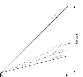
Slope, Average. Calculating the average slope of the disturbed area is based on the elevations at the corners. An imaginary rectangle or square would have to be applied to calculate the area. The average slope is calculated by subtracting the average elevation of the uphill area line and the average elevation of the downhill area line and dividing the sum by the average distance between the two (2) area lines. The average elevation of the uphill or downhill area line is calculated by adding the elevations at the ends of the area line and dividing by two (see Figure 19B, for calculating average slope).
Figure 19B. Calculating Average Slope
Not to Scale
Slope, Steep. A slope greater than 60 percent, identified as part of: (1) a County Soil Survey prepared by the USDA Natural Resources Conservation Service; and/or (2) a site analysis conducted by a registered professional engineer, professional land surveyor, landscape architect, architect or land planner and calculated using topographic maps from an actual survey or from the US Geological Society.
Small Area Zoning Study. An application which is both too large and too disconnected from other zoning districts to be considered as a standard rezoning application and which, should be considered as a small area zoning study based on Planning Board determination.
Soil Erosion and Sedimentation Control Administrator. (See Administrator Soil Erosion and Sedimentation Control).
Solar Energy Generation Facility. Any nonresidential solar collection applications designed to facilitate the capture and conversion of solar energy for the purpose of supplying electricity to utility companies. This definition does not include solar panels accessory to a principal use.
Solid Waste. Hazardous or non-hazardous garbage or other refuse, rubbish, litter, trash, tires, and other discarded solid materials and solid or semisolid waste materials resulting from industrial, commercial and agricultural operations and from community activities, but does not include solids or dissolved materials in domestic sewage or other significant pollutants in water resources, such as silt, dissolved or suspended solids in industrial wastewater effluent, dissolved materials in irrigation return flows or other common waster pollutants. As used herein, “solid waste” shall refer collectively to any or all of the aforementioned waste materials, unless otherwise specified.
Solid Waste Disposal Facility. Any land, personnel and equipment used in the management of solid waste. Solid waste management facilities include the following: transfer stations, landfills or materials recovery facilities. Specifically excluded from this definition and any regulation under this Chapter are: incinerators; drop-off recycling centers; and those solid waste management facilities that are constructed and/or operated by or on behalf of any local, state or federal governmental entity (provided, however, that this exclusion from regulation only applies to those solid waste management facilities not operating as a hazardous waste disposal facility or radioactive waste disposal facility (which are prohibited in all zones)).
Solid Waste Disposal Facility (Flood Damage Prevention). Facility involved in the disposal of solid waste, as defined in NCGS 130A-290(a)(35). Land, personnel and equipment used in the management of solid waste. Solid waste management facilities include the following: (1) transfer station; (2) landfill; or (3) materials recovery facility.
Solid Waste Disposal Site. Any place at which solid wastes are disposed of by incineration, sanitary landfill, or any other method as defined as in (NCGS §130A-290(a)(36)).
Solid Waste Facility, County Owned/Operated. A facility that is owned and operated by Henderson County Government for the purpose of disposing of and/or transferring solid waste. This establishment is primarily engaged in one or more of the following: (1) collecting and/or hauling waste and/or recyclable materials; (2) operating waste transfer stations; (3) disposal of solid waste on land in a sanitary manner; (4) storing solid waste resulting solely from land-clearing activities; (5) receiving recyclable materials via drop-off or by commercial waste haulers; and/or (6) separating and sorting recyclable material from non-hazardous waste streams (excluding sewage and human waste) and where co-mingled recyclable materials are sorted into distinct categories. Accessory uses and structures such as scale houses, loading docks, office buildings associated with the solid waste facility, and any related accessory use or structure are allowed under this definition.
Special Fill Permit. A permit granted pursuant to the procedures set out in of this Chapter to fill an area of the flood fringe greater than the area of flood fringe permitted by this Chapter in accordance with the requirements of this Chapter.
Special Flood Hazard Area (SFHA). The land in the floodplain subject to a one (1) percent or greater chance of being flooded in any given year, determined in §42-232.2 (Basis for Establishing the Special Flood Hazard Areas).
Special Use. Uses that are generally compatible with land uses permitted in a general use district, however, because of their unique characteristics or potential impacts on the surrounding neighborhood and/or the County as a whole, require individual consideration of their location, design, configuration and/or operation at the particular location proposed. A special use must meet both the specific standards for the use as well as the general standards for the issuance of Special Use Permits. Special uses are permitted uses which require a Special Use Permit.
Special Use Permit. A permit issued to authorize development or land uses in a particular zoning district upon presentation of competent, material, and substantial evidence establishing compliance with one or more general standards requiring judgement and discretion be exercised as well as compliance with specific standards.
Start of Construction. Includes substantial improvement, and means the date the building permit was issued, provided the actual start of construction, repair, reconstruction, rehabilitation, addition, placement or other improvement was within 180 days of the permit date. The actual start means either the first placement of permanent construction of a structure (including a manufactured/mobile home) on a site, such as the pouring of slabs or footings, installation of piles, construction of columns, or any work beyond the state of excavation; or the placement of a manufactured/mobile home on a foundation. Permanent construction does not include land preparation, such as clearing, grading and filling; nor does it include the installation of roads and/or walkways; nor does it include excavation for a basement, footings, piers or foundations or the erection of temporary forms; nor does it include the installation on the property of accessory structures, such as garages or sheds not occupied as dwelling units or not part of the main structure. For substantial improvement, the actual start of construction means the first alteration of any wall, ceiling, floor or other structural part of the structure, whether or not that alteration affects the external dimensions of the structure.
State Road Standards. Those standards contained in the NCDOT publication Subdivision Roads–Minimum Construction Standards, dated January 1, 2000, as amended.
Steep Slope. (See Slope, Steep).
Stop-Work Order. The Floodplain Administrator may issue a stop-work order where floodplain development is occurring, in accordance with specific procedures and reasons outlined therefore.
Storm Drainage Facilities. The system of inlets, conduits, channels, ditches and appurtenances which serve to collect and convey stormwater through and from a given drainage area.
Stormwater Best Management Practices (BMP). (See Best Management Practices (BMP), Stormwater).
Stormwater BMP Manual. (See BMP Manual, Stormwater).
Stormwater Runoff. The runoff of water resulting from precipitation in any form.
Structure. That which is built or constructed (North Carolina State Building Code, Chapter 2, Section 202).
Structure (Flood Damage Prevention). A walled and roofed building, a manufactured home, or a gas, liquid, or liquefied gas storage tank that is principally above ground. Anything constructed or erected, the use of which requires permanent location on the ground or which is attached to something having permanent location on the ground; however, anything constructed or erected solely to provide ingress and egress to the site, ornamental enhancement of the property (exclusive of buildings), site stabilization, on-site utilities/lighting or property fencing shall not be considered a structure for the purposes of the floodplain management regulations of this Chapter.
Structure, Accessory. A structure which is located on the same parcel of property as the principal structure, the use of which is incidental to the use of the principal structure. Garages, carports and storage sheds are common accessory structures. Pole barns, hay sheds and the like qualify as accessory structures on farms, and may or may not be located on the same parcel as the farm dwelling or shop building. This term expressly includes aircraft hangars.
Structure, Alternative. A structure which is not primarily constructed for the purpose of holding antennas, but on which one or more antennas may be mounted. Alternative structures include, but are not limited to: buildings, water tanks, pole signs, billboards and electric power transmission towers.
Structure, Appurtenant. (See Structure, Accessory).
Structure, Principal. A structure in which is conducted, or in which is intended to be conducted, the main or principal use of the lot on which it is located.
Structure, Temporary. A structure placed and permitted on a temporary basis.
Structural Stormwater Best Management Practices (BMP). (See Best Management Practices (BMP), Structural Stormwater).
Subdivision. All divisions of a tract or parcel of land into two (2) or more lots, building sites or other divisions for the purpose of sale or development (whether immediate or future) and shall include all divisions of land involving the dedication of a new road or a change in existing roads, but the following shall not be included within this definition:
- Combination or recombination of portions of previously subdivided and recorded lots where the total number of lots is not increased, and the resultant lots are equal to or exceed the standards of this Chapter;
- Division of land into parcels greater than ten (10) acres where no road right-of-way dedication is involved;
- Public acquisition by purchase of strips of land for the widening or opening of roads; or
- Division of a tract in single ownership whose entire area is no greater than two (2) acres into not more than three (3) lots, where no road right-of-way dedication is involved and where the resultant lots are equal to or exceed the standards of this Chapter and the subdivision regulations for the County (NCGS 160D-802).
Subdivision, Major. A proposed subdivision of land where 11 or more lots or parcels will result after the subdivision is complete.
Subdivision, Minor. A proposed subdivision of land where not more than ten (10) lots or parcels will result after the subdivision is complete. One (1) phase of a development cannot be considered a minor subdivision unless the entire development does not exceed ten (10) lots.
Subdivision, Nonstandard. The proposed subdivision of land for purposes other than individual residential lot development including:
- Facilities such as utility substation sites, meter vaults, pump station sites, sign lots, etc.;
- Cemetery plots;
- Designated open space or common area sites; and/or
- Any other subdivision of land which does not fall within a category herein designated.
Subdivision, Special. An option to the minor subdivision provision, where not more than five (5) lots or parcels will result after the subdivision is complete.
Subdivision Administrator. (See Administrator, Subdivision).
Subsidiary. An affiliate that is directly or indirectly, through one or more intermediaries, controlled by another person.
Substantial Damage. Damage of any origin sustained by a structure during any one (1) year period whereby the cost of restoring the structure to its before-damaged condition would equal or exceed 50 percent of the market value of the structure before the damage occurred. Improvements, modifications and additions to existing buildings are counted cumulatively for a minimum of five (5) years. See definition of Substantial Improvement.
Substantial Improvement. Repair, reconstruction, rehabilitation, addition or other improvement of a structure, taking place during any one (1) year period, the cost of which equals or exceeds 50 percent of the fair market value of the structure before the start of construction of the improvement, or when an existing building is structurally altered such that the first floor area is increased by more than 20 percent. Improvements, modifications and additions to existing buildings are counted cumulatively for a minimum of five (5) years. This term includes structures which have incurred substantial damage, regardless of the actual repair work performed. The term does not, however, include either:
- Any correction of existing violations of State or Henderson County health, sanitary or safety code specifications which have been identified by the community code enforcement official and which are the minimum necessary to assure safe living conditions; or
- Any alteration of an historic structure provided that the alteration will not preclude the structure’s continued designation as an historic structure.
Substantial Progress. To determine whether sufficient progress has been made on an approved plan (site or subdivision), one (1) or more of the following construction activities toward the completion of a plan shall occur: (1) obtaining a grading permit and conducting grading activity on a continuous basis and not discontinued for more than 30 days; (2) installation and approval of on-site infrastructure; or (3) obtaining a building permit for the construction and approval of a building foundation. This is not equivalent to the substantial expenditures test used for determining vested rights.
Substantive Amendment. (See Amendment, Substantive).
Swimming Pool, Spa, Hot Tub, Residential. Swimming pools, spas and hot tubs built on the same site as, and for the use of those residing in a dwelling unit.
Synagogue. (See Religious Institution).
Temple. (See Religious Institution).
Ten-Year Storm. A rainfall of an intensity that, based on historical data, is predicted by a method acceptable to the Approving Authority to be equaled or exceeded, on the average, once in ten years, and of a duration that will produce the maximum peak rate of runoff for the watershed of interest under average antecedent wetness conditions.
Tenant. A person, corporation, partnership or group, whether or not the legal owner of record, occupying a building or portion thereof as a unit.
Text Amendment. (See Amendment, Text).
Thoroughfare. Thoroughfares generally feature characteristics of moderate to low mobility and high accessibility. Access control points are allowed, but limited. No control of access is allowed in the category. Traffic signals are allowed and recommended at one-half (½) mile intervals. Driveways are allowed with full movement, but are still recommended to be consolidated or shared if possible. This category includes all roads with a two-way center left-turn lane, but no roads with medians. Speed limits generally are posted between 25 to 55 miles per hour.
Tobacco and Hemp Retail. Tobacco and Hemp Retail means any establishment with the principal sale or distribution of:
- Any product that contains or is claimed in its packaging to contain tobacco or nicotine, irrespective of whether the nicotine is tobacco derived or synthetic, and is intended for human consumption, as defined by G.S. § 14-313(4). “Tobacco product” includes but is not limited to cigarettes, cigars, pipe tobacco, electronic cigarettes, hookah, smoked or vaped tobacco substitutes, chewing tobacco, snuff, snus, dissolvable tobacco products, and heated tobacco products. “Tobacco product” does not include nicotine replacement products approved by the USFDA for treatment of tobacco use and dependence.
- Any product that contains tetrahydrocannabinol (THC), irrespective of whether the THC is hemp derived or synthetic. Products that contain no greater than .3% THC and are not intended for human consumption by swallowing are exempt.
- Any product that contains or claims to contain Mitragyna speciosa, commonly known as kratom.
- Any electronic device that delivers nicotine, THC or other substances to the person inhaling from the device, including, but not limited to, an electronic cigarette, electronic cigar, electronic pipe, vape, or electronic hookah.
- Tobacco and hemp retail shall also mean any establishment which primarily sells tobacco paraphernalia.
Top of Bank. The ordinary high water level for a water basin or wetland, and the break in slope for a watercourse.
Toxic Substance. A substance or combination of substances (including disease-causing agents) which, after discharge and upon exposure, ingestion, inhalation or assimilation into any organism, either directly from the environment or indirectly by ingestion through food chains, has the potential to cause death, disease, behavioral abnormalities, cancer, genetic mutations, physiological malfunctions (including malfunctions or suppression in reproduction or growth) or physical deformities in such organisms or their offspring or other adverse health effects.
Tract. An area, site, piece of land or property which is the subject of a development application. A tract may contain one or more smaller parcels or lots all under/in the same ownership or control.
Tract (Soil Erosion and Sedimentation Control). All contiguous land and bodies of water being disturbed or to be disturbed as a unit, regardless of ownership.
Trail. A public or private path of travel for recreation and/or transportation within a park, natural environment or designated corridor (not to be a highway or road).
Transit and Ground Passenger Transportation. An establishment comprised of a variety of passenger transportation activities such as: chartered bus, school bus, interurban bus transportation and taxis. These activities are defined by vehicle type, route and schedule.
Travel Trailer. (See Recreational Vehicle).
Travel Trailer Park. (See Recreational Vehicle Park).
Traveled Way. A means of access to a property. Typically this shall mean a public or private road. Where no public or private road adjoins a property, the vehicular access to a personal drive shall be considered as the traveled way for purposes of determining front yard requirements.
Traveled Way, Edge. The edge of the road pavement on a paved road or the edge of the riding surface on an unpaved road or drive.
Travelway. The portion of a road, highway, driveway, access road corridor, right-of-way, etc., that is designed and maintained for the purpose of accommodating vehicular passage. Specifically excluded are road shoulders, ditches, curb and gutter systems, other drainage facilities and unimproved road rights-of-way not intended to be driven on by vehicles.
TRC. Technical Review Committee.
Tree. A living, self-supporting woody perennial plant which normally obtains a trunk diameter of at least two (2) inches and a height of at least ten (10) feet, and typically has one (1) main stem and many branches.
Tree, Large. A tree whose height under average regional growing conditions will exceed 35 feet in height at maturity.
Tree, Small. A tree whose height under average regional growing conditions will be 35 feet in height or less at maturity.
Truck Terminals. An establishment primarily engaged in providing services to trucks which may include offices of transport companies, easy loading and unloading facilities and large parking areas for idle trucks.
Twenty-Five Year Storm. The stormwater runoff resulting from precipitation of an intensity that, based on historical data, is predicted by a method acceptable to the Approving Authority to be equaled or exceeded on the average, once in 25 years, and of a duration which will produce the maximum peak rate of runoff for the watershed of interest under average antecedent wetness conditions.
Uncovered. The removal of ground cover from, on, or above the soil surface.
Undertaken (Soil Erosion and Sedimentation Control). The initiating of any activity, or phase of activity, which results or will result in a change in the ground cover or topography of a tract of land.
Unique Natural Area. An area that meets the criteria for qualifications as a natural heritage area as prescribed in NCAC Chapter 15A-12H, Section 0202.
Urgent Care Clinic. A full service walk-in medical clinic (which may include a physical therapy facility) which provides immediate/urgent health care services (including services for individuals with sudden, serious and unexpected illnesses, injuries or conditions which require immediate medical attention) but which does not provide emergency medical/emergency room services.
Use. The purpose or activity for which a piece of land (or portion thereof) and/or its structures (or portion thereof) is/are designed, arranged or intended or for which it/they is/are occupied or maintained.
Use, Accessory. A use customarily incidental and subordinate to a principal use, located within a principal and/or accessory structure.
Use, Existing. Those uses that, at a minimum, have established a vested right under North Carolina zoning law.
Use, Principal. The specific primary purpose for which land is used.
Use, Temporary. A use permitted on a temporary basis.
Use District. A zone established through this Chapter which regulates the use of land. use districts are applied to particular tracts of land by the Board of Commissioners through a zoning map amendment in accordance with this Chapter. When a use district is applied to a particular tract of land, the land is said to have been “zoned.” Use districts each contain a variety of uses which are generally compatible with one another and which accomplish the stated purpose of the district.
USGS. United States Geological Survey.
Utility Substation. Substation engaged in the operating of utilities such as, but not limited to, electricity, water, sewer, telephone and cable. Substations arrange, facilitate or coordinate the transmission of a utility from the generating source to the distribution centers, other utilities or final consumers.
Variance. A grant of relief from the requirements of this Chapter (excluding variances from watershed and floodplain development requirements).
Variance, Accommodative Temporary. (See Variance).
Variance (Flood Damage Prevention). A grant of relief from the requirements of this Chapter related to flood damage prevention regulations.
Variance, Watershed Local. A variance from the minimum statewide water supply watershed protection criteria that results in the relaxation, by a factor of up to five (5) percent of any buffer, density or built-upon area requirement under the high density option; or that results in a relaxation, by a factor of up to ten (10) percent, of any management requirement under the low-density option.
Variance, Watershed Major. A variance from the minimum statewide water supply watershed protection criteria that results in any of the following:
- The relaxation, by a factor greater than ten (10) percent, of any management requirement under the low-density option;
- The relaxation, by a factor greater than five (5) percent, of any buffer, density or built-upon area requirement under the high density option; and
- Any variation in the design, maintenance or operation requirements of a wet detention pond or other approved stormwater control system.
Vehicle (Gate Regulations). Any motor vehicle which is allowed to use the public roadways in North Carolina, but not including vehicles which include trailers or semi-trailers (See Chapter 47 of the Henderson County Code, Entry Gate).
Vehicle Graveyard. A parcel of land having an accessory use consisting of the storage or keeping of five (5) or more wrecked, scrapped, ruined, dismantled, junked or inoperable motor vehicles (including but not limited to cars, trucks, tractor trailers, boats, motorcycles or jet skis or other motorized equipment) located on a land parcel or adjacent land parcels under the same ownership or control, if such storage or keeping is not enclosed within a structure(s).
Velocity. The speed of flow through a cross section perpendicular to the direction of the main channel at the peak flow of the storm of interest but not exceeding bank full flows.
Vertical Clearance. A minimum established height clearance required for the passage of emergency vehicles. For the purposes of this Chapter, vertical clearance shall be a minimum of 13 feet, six (6) inches.
Violation. The failure of a structure or other development to be fully compliant with the County’s regulations.
Violation (Flood Damage Prevention). The failure of a structure or other development to be fully compliant with the County’s floodplain management regulations. A structure or other development without an elevation certificate, other certifications or other evidence of compliance required in §42-234 (Administration) and §42-235 (Flood Hazard Reduction) is presumed to be in violation until such time as that documentation is provided.
Warehousing and Storage. An establishment primarily engaged in operating warehousing and storage facilities (excluding warehousing of hazardous substances).
Waste (Soil Erosion and Sedimentation Control). Surplus materials resulting from on-site land-disturbing activities and being disposed of at other locations.
Waste Collection and Transfer Facility (Hazardous). An establishment primarily engaged in: (1) collecting and/or hauling hazardous waste; and/or (2) operating hazardous waste transfer stations. Hazardous waste collection establishments may be responsible for the identification, treatment, packaging and labeling of wastes for the purposes of transport.
Waste Collection and Transfer Facility (Non-hazardous). An establishment primarily engaged in: (1) collecting and/or hauling non-hazardous waste and/or recyclable materials; and/or (2) operating non-hazardous waste transfer stations. Non-hazardous waste collection establishments may be responsible for the identification, treatment, packaging and labeling of wastes for the purposes of transport.
Wastewater. Sewage or industrial process wastewater discharged, transmitted or collected from any place into sewage disposal (wastewater) system.
Wastewater Treatment Plant. A facility containing a series of tanks, screens, filters, and other combination of physical, chemical and biological processes to treat wastewater so that less harmful byproducts result as pollutants are removed.
Wastewater Treatment Plant, Small Accessory. A facility, including package wastewater treatment plants, containing a series of tanks, screens, filters, and other combination of physical, chemical and biological processes to treat wastewater so that less harmful byproducts result as pollutants are removed. These facilities are intended to be accessory to and used for a single development (i.e. subdivision, shopping mall, etc.), and is not designed to serve multiple developments.
Water Dependent Structure. Structure for which the use requires access to, proximity to or siting within surface waters to fulfill its basic purpose such as boat ramps, boathouses, piers, docks and bulkheads. Ancillary facilities, such as restaurants, outlets for boat supplies, parking lots and commercial boat storage areas are not water dependent structures.
Water Supply System. A system for the collection, treatment, storage and distribution of potable water from the source of supply to the consumer and which may be of the following types: private well water supply system, public water supply system, and municipal water supply system.
Water Supply System, Municipal. A water supply system owned and operated by a local government.
Water Supply System, Private Well. A water supply water system furnishing potable water to less than 15 connections or 25 persons.
Water Supply System, Public. A municipal water supply system or:
- A system for the provision to the public of piped water for human consumption that serves 15 or more service connections or which regularly serves 25 or more individuals. The term includes:
- Any collection, treatment, storage or distribution facility under the control of the operator of the system and used primarily in connection with the system; or
- Any collection or pretreatment storage facility not under the control of the operator of the system that is used primarily in connection with the system.
- A “community water system” or a “noncommunity water system” as follows:
- “Community water system” is a public water supply system that serves 15 or more service connections or which regularly serves at least 25 year-round residents.
- “Noncommunity water system” is a public water supply system that is not a community water system.
Water Supply Watershed. An area designated by the North Carolina Environmental Management Commission, delineated on the official map entitled "Henderson County Water Supply Watershed Protection Map," and regulated by this Chapter.
Water Surface Elevation (WSE). The height, in relation to mean sea level, of floods of various magnitudes and frequencies in the floodplains of riverine areas.
Watercourse (Flood). A lake, river, creek, stream, wash, channel, or other topographic feature on or over which waters flow at least periodically. Watercourse includes specifically designated areas in which substantial flood damage may occur.
Watershed. The entire land area contributing surface drainage to a specific point, such as the water supply intake.
Water Quality Administrator. (See Administrator, Water Quality).
Watershed Map. A map on file with the Water Quality Administrator which may be produced digitally at different scales, titled "Henderson County Water Supply Watershed Map," which shows the boundaries of each watershed district and their respective classification, where such map is approved by the Henderson County Board of Commissioners and includes, at a minimum, the watershed districts adopted by the North Carolina Environmental Management Commission or any other authorized agency of the state.
Wetlands. Lands transitional between terrestrial and aquatic systems where the water table is usually at or near the surface or the land is covered by shallow water. For purposes of this classification wetlands must have one or more of the following three (3) attributes: (1) at least periodically, the land supports predominantly hydrophytes; (2) the substrate is predominantly undrained hydric soil; and (3) the substrate is nonsoil and is saturated with water or covered by shallow water at some time during the growing season of the year (US Fish and Wildlife Service, National Wetlands Inventory).
Wholesale Trade. An establishment primarily engaged in selling and/or arranging the purchase of goods to other businesses at wholesale.
Working Days. Days exclusive of Saturday and Sunday during which weather conditions or soil conditions permit land-disturbing activity to be undertaken.
WS. Watershed.
Yard. An open space on the same lot with a structure.
Yard, Front. An open, unoccupied space on the same lot with a principal structure, extending the full width of the lot and situated between the road or property line and the front line of the structure, projected to the sidelines of the lot.
Yard, Rear. An open, unoccupied space on the same lot with a principal structure, extending the full width of the lot and situated between the rear property line and the rear line of the structure, projected to the sidelines of the lot.
Yard Sale. A temporary use for the purpose of informal sales conducted by occupants of private households at their dwelling premises (including garage, porch, carport and estate auction sales).
Yard, Side. An open, unoccupied space on the same lot with a principal structure situated between the structure and the side property line and extending from the rear line of the front yard to the front line of the rear yard.
Youth Center. An establishment primarily engaged in providing nonresidential social assistance services for children and youth. These establishments provide for the welfare of children in such areas as adoption and foster care, drug prevention, life skills training and positive social development. This excludes those youth centers for recreational purposes only.
ZBA. Zoning Board of Adjustment.
Zoning Administrator. (See Administrator, Zoning).
Zoning Compliance Inspection. A zoning compliance inspection is made, where required, following the issuance of a zoning permit and prior to the issuance of a Certificate of Occupancy.
Zoning Map/Henderson County Zoning Map. The Official Zoning Map of Henderson County.
Zoning Permit. A permit issued by the County conferring the right to undertake and complete the development of and use of property in accordance with the standards of this Chapter.