Subpart D. Subdivision Road Standards Applicable to All Subdivision Types and Subtypes
North Carolina General Statute (NCGS) §136-102.6 requires a developer disclose to each buyer of property the following:
- The ownership (public or private) of the road serving the lot,
- How the road will be maintained, and
- Who shall be responsible for such maintenance.
The law further requires certain road maintenance agreements be executed.
Right-of-way standards apply within the property being developed. Rights-of-way shall be capable of supporting a road by meeting the minimum width specified by this Chapter (See Table 3.3). Any portion of an existing recorded right-of-way which does not meet minimum width requirements of this Chapter shall be upgraded to:
- Meet the full right-of-way requirement when the right-of-way is surrounded by or abutting the tract; or
- Provide one-half (1/2) of the required right-of-way (measured from the centerline of the existing right-of- way) when the right-of-way is not completely contained by the tract to be subdivided.
Access to a proposed subdivision through another County shall meet or exceed all right-of-way and road requirements herein.
Any portion of an existing private road located in an existing recorded private right-of-way and surrounded by the tract to be subdivided shall be upgraded to meet the road standards of this Subpart C (Subdivision Road Standards Applicable to All Subdivision Types and Subtypes) in major subdivisions.
Roads should be constructed (1) along the contour of the land because of the difficulty of operating vehicles on steep grades and high potential for erosion, and (2) so that water will drain from the road surface into side ditches.
Roads shall:
- Be constructed with suitable stone and compacted properly,
- Be constructed on a sub base of suitable soil capable of supporting it, and
- Not be constructed on used asphalt (an unacceptable base course).
The Subdivision Administrator may require a professional engineer or professional surveyor to certify, or provide applicable proof, that the roads were constructed to standards prescribed in this Subpart D (Subdivision Road Standards Applicable to All Subdivision Types and Subtypes) and approved development plan. This may be accomplished by on-site supervision by the engineer or his designee during the construction of the road, or through a series of core sample tests at appropriate key areas or as requested by the Subdivision Administrator. The core samples should be spaced accordingly and the location and number of core samples should be agreed upon by the engineer and Subdivision Administrator prior to testing. NCDOT certification is not required.
Permanent stabilization of soils to prevent erosion shall be achieved by seeding areas disturbed by the construction of a road (including cut and fill slopes, shoulders, ditch banks, etc.) as soon as feasible after road construction. The Subdivision Administrator, where seasonal weather prevents seeding, may require:
- An improvement guarantee be posted with the County to ensure the installation of permanent stabilization; and
- Other materials (straw, mulch, etc.) are applied temporarily until seed can be sewn
Road names are required for all public and private roads (including alleys and driveway easements) that access more than two (2) lots. Proposed names for roads shall:
- Be pre-approved by Henderson County in accordance with Chapter 41 of the Henderson County Code, Property Addressing.
A proposed road obviously in alignment with an existing named road shall bear the name of existing road.
Road name signs and regulatory signs (speed limit signs, stop signs, etc.) shall be provided in accordance with Chapter 41 of the Henderson County Code, Property Addressing and with applicable local, state and federal laws, rules and regulations. Road name signs and regulatory signs must be acquired and installed prior to final plat approval.
Road drainage structures, ditches, and culverts shall be designed and constructed in accordance with State Road Standards and with sufficient depth and width to carry the expected volume of stormwater runoff. Culverts may be required where the road crosses streams or minor watercourses. Best Management Practices should be utilized for road swales (turf matting and vegetation, etc.) to control erosion and transport of sediment and to filter pollutants from stormwater runoff.
Stub roads shall be designed in locations which will permit the future extension of subdivision roads.
Applicants shall indicate if roads are to be public or private on applications, plans and plats. Where private roads are proposed as extensions of existing public roads, the developer must clearly justify why proposed roads should not be extended for public use. Private roads may become public if accepted into the public road system by NCDOT.
- Public Roads. Public roads (and their associated public bridges) shall:
- Be designed and constructed in accordance with State Road Standards.
- Be offered dedication to the public (though this does not guarantee NCDOT will accept or agree to assume the maintenance responsibility of the proposed public road).
- Private Roads. Private roads shall be the standards of this Subpart D (Subdivision Road Standards Applicable to All Subdivision Types and Subtypes).
Private roads and bridges shall be built to State Road Standards for commercial, office institutional, industrial or mixed-use subdivisions.
If not specified in Article III (Subdivision Regulations) Subpart D (Subdivision Road Standards Applicable to All Subdivision Types and Subtypes), the design and construction of private roads shall be reviewed using NCDOT standards and requirements which reflect local NCDOT District Engineer policy modifications.
Private roads shall: (1) Be designated based on the number of lots served (See Table 3.2); (2) be designed and constructed in accordance with the standards of this Article III (Subdivision Regulations) (see Table 3.3); and (3) be designed to provide, at all times, adequate and unobstructed access for emergency response.
| General Use District | |||||
|---|---|---|---|---|---|
| Road Classification | Subdivision Collector | Subdivision Local | Limited Local | Private Driveway Easement | Alley |
| Number of Residential Lots Served | 50+ | 6 to 49 | 1-5 | 1-5 | 1-49 |
Private roads shall meet the minimum design and construction standards according to the following road classifications:
- Private Subdivision Collector Road. A “private subdivision collector road” shall be required where the road serves:
- 50 or more units (existing or proposed) within the proposed subdivision or as an aggregate of the proposed subdivision and any other development to which it connects,
- As a through-road connecting lots within a subdivision to more than one (1) public thoroughfare, or
- A nonresidential facility within a residential development, (i.e. clubhouse, golf course, etc.)
- Private Subdivision Local Road. A “private subdivision local road” shall be required where a private subdivision collector road is not required and a private subdivision limited local road is not permitted.
- Private Subdivision Limited Local Road. A “private subdivision limited local road” shall be permitted where the road serves:
- No more than five (5) lots or principal units.
- Only as a maintenance and/or emergency access (regardless of the number of lots it adjoins provided the road shall not be used to access lots and appropriate signage is provided).
- Private Driveway Easements. A private “driveway easement” shall be permitted where the driveway serves no more than five (5) lots (the lots served by the easement shall be identified on all plans and plats). Final plats must contain a note conveying maintenance responsibility of the easement to the homeowners’ utilizing it to access their property. The note shall state easement(s) must be maintained to allow clear passage for emergency response vehicles. Private driveway easements are not allowed in major major subdivisions unless 2/3 of lot owners (1 vote per owner(s), not one vote per lot) approves the request.
- Where private driveway easements are used, the surveyor or engineer shall place and execute the following certification on the plat with their seal and registration or license number.
I, ________________________________________, Professional Land Surveyor or Professional Engineer, certify that the lot(s) created by this plat is (are) served and accessed by a recorded driveway easement shown here on. This easement may or may not meet the standards for roads serving subdivisions in the Henderson County Land Development Code. Neither the undersigned nor Henderson County certifies whether this easement meets such standards. This the _________ day of ______, 20____.
________________________________ Professional Surveyor or Engineer
- Alley. An alley shall be permitted where the residential lot is also accessible by another public or private road and the alley serves as primary access for the future homeowner and for utility services (i.e. trash collection). Visitors to the residential lot will use the principal access road to the property.
- Center Line Curve Radius. The pavement width and stone base indicated in Table 3.3 shall be increased within the curve where the road centerline is less than a 90-foot radius. If the radius is 70 to 90 feet, increase pavement and stone base width by 25 percent. If the radius is 60 to 70 feet, increase the pavement and stone base width by 35 percent. If the radius is 50 to 60 feet, increase the pavement and stone base width by 45 percent. If the radius is 40 to 50 feet, increase the pavement and stone base width by 50 percent. No turn radius shall be less than 40 feet.
|
|
||||||
|
Requirements |
Private Road Classification |
|||||
|
Subdivision Collector |
Subdivision Local |
Limited Local |
Private Driveway Easement |
Alley |
||
|
Number of Residential Lots Served |
50+ |
6 to 49 |
1-5 |
1-5 |
1-49 |
|
|
Right-of-Way Width (ft.) |
Roads (feet) |
50 |
45 |
30 |
- |
20 |
|
Cul-de-sac (radius) |
- |
50 |
50 |
- |
- |
|
|
Easement Width (ft.) |
- |
- |
- |
30 |
- |
|
|
Sight Distance on Vertical Curves (ft.) |
150 |
110 |
110 |
- |
- |
|
|
Center Line Curve Radius (ft.) – See section F. below |
90 |
90 |
90 |
- |
- |
|
|
Maximum Grade % |
Stone Only |
12 |
15 |
15 |
- |
- |
|
Paved Surface |
16 |
18 |
18 |
- |
- |
|
|
Minimum Travelway Width (ft.) (two-way road) |
18 |
16 |
16 |
- |
12 |
|
|
Minimum Travelway Width (ft.) (one-way road) |
12 |
12 |
12 |
- |
12 |
|
|
Shoulder Width (each side, two-way road) (ft.) |
6 |
4 |
2 |
- |
- |
|
|
Shoulder Width (each side, one-way road) (ft.) |
2 |
2 |
2 |
- |
- |
|
|
Stone Base (ABC) Compacted (in.) |
8 |
6 |
6 |
- |
- |
|
|
Asphalt |
(1½ of S-9.5B or BST) |
|||||
|
Cut and Fill Slope |
2:1 |
1.5:1 |
1.5:1 |
- |
- |
|
|
Ditch Slope |
4:1 |
3:1 |
3:1 |
- |
- |
|
|
Vertical Clearance (ft.) |
13.5 |
13.5 |
13.5 |
13.5 |
13.5 |
|
- Intersections. Acceptable angles of intersection are:
- 90 to 75 degrees (preferred)
- 75 to 60 degrees (acceptable under extreme conditions as determined by the reviewing agency).
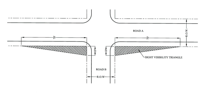
- Adequate Sight Distances. Adequate sight distances (see Figure 3B. Sight Visibility Triangle) along a proposed road shall be provided by:
- Choosing a good location for the right-of-way and clearing sight visibility triangles when constructing the road (the minimum sight distance is 70 feet along the “existing” road right-of-way and ten (10) feet along the “new” road right-of-way).
- Providing an adequate place for vehicles to stop before entering the road.
- Providing an apron design at proposed intersections to permit a vehicle to enter when another vehicle is waiting to turn.
Figure 3B. Sight Visibility Triangle
Not to Scale
- Gates. Entry gates shall be constructed and maintained as required by and in accordance with Chapter 47 of the Henderson County Code, Entry Gates, and SR 3.7 (Gates and/or Guardhouses).
- Dead Ends, Cul-de-sacs and Turnarounds. Vehicle turnaround areas shall be provided at the end of all dead-end roads (excluding private driveway easements) that exceed 300 feet. Loop roads should be encouraged where possible in lieu of cul-de-sac or turnarounds. The reviewing agency may also require installation of turnarounds at:
- Intermediate locations along dead end roads with a centerline length of greater than 2,500 feet.
- The end of a phase of a project.
- An intermediate location along any road that exceeds 1,500 feet in length.
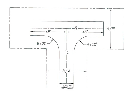
Acceptable alternative turnaround designs for residential subdivisions are shown in Figures 3C, 3D, and 3E. Turnaround areas of a dead-end road cul-de-sac shall have a radius of not less than 35 feet.
Figure 3C. Alternative Turnaround Design - Island
Not to Scale
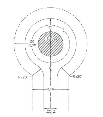
Figure 3D. Alternative Turnaround Design - Branch Turnaround
Not to Scale
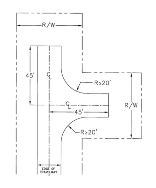
Figure 3E. Alternative Turnaround Design – T Turnaround
Not to Scale
- Bridges. Bridges shall:
- Be engineered to a minimum weight capacity of 50,000 pounds (For purposes of emergency management vehicle access) and documentation shall be provided to indicate such (the 50,000 pound weight capacity requirement shall not apply to driveways);
- Adhere to State Road Standards for drainage, hydraulics and minimum live load;
- Adhere to standards for vertical clearance for roads (See Table 3.3);
- Provide a travelway width not less than the travelway width of the road on either side of the bridge, and in no case less than 12 feet in width;
- Include a paved or gravel turnout on each end of the bridge to provide space for at least one (1) vehicle to safely pull over and allow an oncoming vehicle to traverse the bridge where the travelway width is less than 18 feet and is proposed to accommodate two-way traffic; and
- Provide adequate line-of-sight distances for safe operation of two-way traffic.
- Right-of-way Width Reduction. Right-of-way width requirements may be reduced to 30 feet in width where no more than five (5) lots are proposed and it is unlikely (due to design, topographic conditions or existing development) that any road contained therein would be extended to serve more than five (5) lots.
- Centerline Curve Radius Reductions. Centerline curve radius reductions may be reduced to:
- 80 feet where the existing cross slope on private subdivision collector roads is 15 percent or greater, or
- 60 feet where the existing cross slope on private subdivision limited local residential subdivision roads or private subdivision local residential subdivision roads is 15 percent or greater.
- Shoulder Width Reduction. Shoulder width shall be reduced for:
- Private subdivision local roads and private subdivision collector roads to a minimum of two (2) feet in cases where the existing cross slope is 20 percent or greater; and
- Private subdivision collector roads to a minimum of four (4) feet in cases where the existing cross slope is greater than ten (10) but less than 20 percent or greater.
- Cut and Fill Slopes. Cut and fill slopes shall be reduced to 1:1 where the existing cross slope is 20 percent or greater. Additional erosion control measures are required in areas where cut and fill slopes utilize this reduction. Enforced by the Erosion Control Administrator.