ARTICLE III. SUBDIVISION REGULATIONS
42-74. Purpose
The purpose of this Article III (Subdivision Regulations) is to promote, through proper planning, health, safety and general welfare by providing for the orderly subdivision of land in Henderson County. This Article III (Subdivision Regulations) is deemed necessary to:
- Establish procedures and standards for the subdivision of land;
- Provide for orderly growth and development;
- Protect and enhance property ownership and land values;
- Provide for dedication or reservation of road right-of-way;
- Assure the proper design and installation of roads and utilities;
- Assure proper legal description, identification and recordation of property boundaries to maintain an accurate, up-to-date land records management system;
- Promote environmental quality;
- Preserve areas of the County with productive soils for continued agricultural and forestry use by preserving blocks of land large enough to allow for efficient operation;
- Encourage the maintenance and enhancement of habitat for various forms of wildlife and to create new woodlands through natural succession and reforestation where appropriate;
- Minimize site disturbance and erosion through retention of existing vegetation and avoiding development on steep slopes; and
- Preserve open land, including those lands that contain unique (and sensitive) natural areas.
42-75. Comprehensive Plan
This Article III (Subdivision Regulations) is based on Comprehensive Plan goals and objectives. All land may not be suitable to be subdivided for the purpose of dense development due to:
- Severe topographic conditions;
- Inadequate road access;
- Distance from services;
- Unique natural areas;
- Soils that do not easily support soil drainage systems; and/or
- The proximity to existing and incompatible land uses/zoning
The reviewing agency should consider Comprehensive Plan goals and objectives when reviewing subdivisions.
42-76. Approval for Subdivision Plats
A final plat must be prepared and approved when a subdivision of land occurs (See §42-342). Final plats must be recorded within 18 months of approval or they become null and void and must be re-approved by the appropriate authority.
42-77. Land Disturbing and Construction Activity
No land disturbing or construction activity carried out in conjunction with the development of a subdivision shall begin
until a development plan has been approved.
42-78. Subdivision Types
Subdivisions shall be either: special, minor, nonstandard or major. Each type of subdivision includes subtypes:
- Nonstandard Subdivision Subtypes. Public utility (pump station, water tank, etc.), auxiliary lot (sign lot, common area, etc.) or cemetery lot (specifically excluding residential, commercial, office institutional, industrial or mixed-use).
- Special Subdivision Subtypes. Residential.
- Minor Subdivision Subtypes. Residential.
- Major Subdivision Subtypes. Residential, commercial, office institutional, industrial or mixed-use.
42-79. Aggregation
Two or more developments may be aggregated and treated as a single development under the Land Development Code when they are determined to be part of a unified plan of development and are physically proximate to one another. Each of the criteria listed below is indicative of a unified plan of development. Whenever one or more are found to exist, the reviewing authority may determine that two or more projects are part of a unified plan of development:
- There is a reasonable closeness in time between the completion of some or all of one development and the submission of an application for authorization of other development which is indicative of a common developmental effort;
- A master plan or series of plans or drawings exists covering the development sought to be aggregated;
- There is a voluntary sharing of infrastructure that is indicative of a common development effort or is designated specifically to accommodate the developments sought to be aggregated;
- There is a common advertising scheme or promotional plan in effect for the developments sought to be aggregated.
42-80 Reserved
42-81 Reserved
42-82. Road Frontage and Existing Off-Site Access
Tracts to be subdivided must have a minimum of: (1) 30 feet of frontage on an existing public road, or (2) private
rights-of-way no less than 30 feet in width to a public road. Applicants shall have the burden to prove private right-of-
way and existing off-site access is legal, permissible and permanent (evidence may include property deed, title search,
recorded plat, or other documentation provided by the applicant).
Where the minimum frontage and off-site access requirements cannot be met the maximum number of lots
into which a tract may be divided shall be no more than one (1) lot per acre.
Where the minimum road frontage and existing off-site access requirements can be met but the grade of the
road at any point in the existing off-site access exceeds 18 percent (paved) or 15 percent (gravel), and the applicant is
proposing more than five (5) lots, the approving agency will review the application on a case-by-case basis.
42-83. Lot Designs
New subdivision lots shall:
- Abut on an approved road or driveway easement (See §42-108, Residential Private Road Standards by Road Classification);
- Be no narrower than 30 feet in width where abutting the right-of-way or for purposes of the driveway easement;
- Be calculated excluding road right-of-way to determine size;
- Be of a size, width, depth, shape and orientation reasonable for the type of development;
- Where possible, have side lot lines at right angles or radial to the roads faced; and
- Provide the approved E911 identification.
42-84. Certificate of Understanding
This certificate shall:
-
Be signed by the property owner(s) and provided at the time of subdivision application submittal:
- Acknowledge that all lots created from a parent tract will count toward the total number of lots permitted
under density regulations.
- Acknowledge that upgrading existing improvements (including roads) may be necessary in order to expand.
42-85. Subdivision Names and Name Signs
The name of a subdivision shall not be substantially identical or similar as to likely cause confusion among prospective
purchasers to any other subdivision or named community in the County. A community identification/subdivision sign:
(1) may be provided at the primary entrance, (2) shall be in conformance with the sign regulations of Article VII (Sign
Regulations), and (3) should be located in dedicated sign easements.
42-86. Cemeteries
Existing cemeteries shall be deeded as a separate lot in the subdivision and shall be accessed by a minimum twenty (20) foot wide private or public easement. Major subdivisions shall provide access with a minimum twenty (20) foot wide right-of-way (road construction is not required).
42-87. Advisory Provisions
- Soils Map. Applicants for subdivisions with lots smaller than one (1) acre in size should consult a soils map of the property and be knowledgeable of the suitability of ground absorption systems on the property.
- Utility Easements. Utility easements should be:
- Centered on rear or side lot lines,
- At least 20 feet in total width, and
- Identified following discussion with the appropriate utility agency.
- Stream Setbacks. See §42-250 (Perennial and Intermittent Surface Water Buffers).
- Traffic Impact Study (TIS) and Emergency Services Impact Report (ESIR). See Article IV (Adequate Public Facilities Regulations) for traffic impact study and emergency services impact report requirements.
42-88. Conservation Subdivision Standards
Conservation subdivision standards shall apply to all subdivisions proposing 35 lots or more.
- Open space shall:
- Comprise a minimum of 25 percent of the project area. Subdivisions proposing 100 or more lots may not use the floodway area to determine the overall density calculation but may count the floodway area for open space requirements. Floodplain areas are allowed to be calculated for both density and open space requirements.
- Be composed of (in order of which lands should be designated as open space first): primary conservation area, secondary conservation area, and any remaining lands necessary.
- Be designated so that a minimum of 50 percent of the proposed open space is contiguous and, where possible, adjoins open space or other protected areas (including protected forests or wildlife areas) outside the project area.
- Be designated so that, where possible, a majority of the lots directly abut open space to provide residents with direct views and access.
- Be accessible by safe and convenient pedestrian access from all adjoining lots (except in the case of farmland or other resources areas vulnerable to trampling damage or human disturbance).
- Be used as follows:
- Conservation of natural resources, archeological resources or historical resources;
- Agriculture, horticulture, or silviculture, provided all applicable best management practices are used to minimize environmental impacts;
- Passive recreation;
- Active recreation provided impervious surfaces are limited to a maximum of 12 percent of the total open space area;
- Nonstructural stormwater management practices;
- Easements for drainage, access, and underground utility lines; and
- Water, septic, and sewer systems.
- Not be used as follows:
- For motor vehicles (except for maintenance purposes as provided for in the Open Space Management Plan); and
- Roads, parking lots and impervious surfaces (except when accessory to active recreational uses).
- Open Space Ownership. The applicant must identify current and future owner(s) of open space responsible for maintaining the area/facilities. The responsibility for maintaining the open space and its facilities shall be borne by the owner. If a homeowners’ association is the owner:
- Membership in the association shall be mandatory and automatic for all homeowners in the subdivision and their successors; and
- The association shall have lien authority to ensure the collection of dues from all members.
- Open Space Management. The applicant shall submit “Open Space Management Plan” which includes:
- A statement allocating maintenance responsibilities and establishing guidelines for the upkeep of open space and its facilities;
- Cost estimates for maintenance, operation and insurance needs for the open space;
- A means by which funds will be obtained for all management expenses;
- A provision allowing the Subdivision Administrator to approve plan change; and
- Criteria for plan enforcement.
- Legal Instrument for Permanent Protection. Open space shall be protected in perpetuity by a binding legal document recorded with the deed. The document shall be one of the following:
- Permanent conservation easement in favor of either:
- A land trust or similar conservation-oriented non-profit organization with legal authority to accept such easements. The organization shall be bona fide and in perpetual existence and the conveyance instruments shall contain an appropriate provision for retransfer in the event the organization becomes unable to carry out its functions; or
- A governmental entity with an interest in pursuing goals consistent with the intentions of this Section.
- Permanent restrictive covenant for conservation purposes.
- Equivalent legal tool providing permanent protection, subject to approval by the County Attorney. The instrument shall include all restrictions contained in §42-87 (Conservation Subdivision Standards), and any further restrictions the applicant chooses to place on the use of the open space.
- Permanent conservation easement in favor of either:
- Open Space Density Bonus. Base density is determined by the zoning district in which the subdivision is located. Conservation subdivisions proposing more than the minimum required open space may be eligible for increased densities. Table 3.1outlines the criteria for density bonuses. Lands under conservation easement shall not be counted when determining density bonuses. Permitted housing densities shall not exceed the maximum allowances of any applicable water supply watershed requirements.
Table 3.1. Open Space Density Bonuses Percent Open Space (%) 25-30 31-40 41-50 >51 Percent Housing Density Increases (%) N/A 10 15 20 - Agricultural Preservation Density Bonus. Base density is determined by the zoning district in which the subdivision is located. Conservation subdivisions proposed for sustaining existing on-site bona fide agricultural operations are entitled to a five (5) percent increase in permitted density. Residential lots in these subdivisions should be located in areas less suitable for agricultural production with prime farmland being preserved as open space. Lots should be located where agricultural operations do not interfere with the safety and well being of future residents. The reviewing agency may require vegetative buffering and/or additional setbacks between agricultural operations and lots to mitigate potential impacts of noise, vibration, light, and/or odor. This five (5) percent bonus may be used in conjunction and in addition to any applicable open space density bonus. Permitted housing densities shall not exceed the maximum allowances of any applicable water supply watershed requirements.
- Structure Placement. Structures should be placed as closely to internal roads as permitted. The reviewing agency may reduce the front yard setback to a minimum of five (5) feet; taking into consideration sound engineering, public safety concerns and community character when applying the standards. Structures may be: (1) located in the side yard setback required by the zoning district regulations; and (2) placed as closely together as permitted by the North Carolina State Building Code.
- Exemption. Conservation subdivision standards can be applied to any subdivision type, but are not required by this Chapter.
42-89. Reserved
42-90. Reserved
42-91. Reserved
42-92. Nonstandard Subdivisions
Nonstandard subdivision lots shall:
- Be exempt from the density requirements of this Chapter.
- Include auxiliary lots (the structures located thereon must meet any applicable zoning or water supply watershed requirements) clearly identified for a designated use.
- Be identified and encumbered to its specified use on a final plat.
- Be provided with a platted or deeded right-of-way that connects each proposed lot and remainder parcel to a public road.
- Not be counted in the number of lots in a subdivision for administrative purposes.
42-93. Special Subdivisions
Special subdivisions shall be permitted under the following conditions:
A. For lots of record prior to September 19, 2007 where there is insufficient acreage to meet the density regulations of the zoning districts, up to five (5) lots may be created where each lot is at least one half (1/2) acre (21,780 square feet) in size.
B. The special subdivision procedure may not be used in conjunction with an application for a minor subdivision or a major subdivision.
The special subdivision procedure does not apply to the following zoning districts: Estate Residential (R-40), Surface Water District (SW), and Waterfront Residential (WR).
42-94. Minor Subdivisions (Ten(10) or Fewer Lots)
Minor subdivisions shall adhere to all applicable requirements of this Chapter. No more than ten (10) lots in a five (5) year time period shall be allowed unless the subdivision complies with the major subdivision standards.
42-95. Major Subdivisions (Eleven (11 or more Lots or Commercial, Office Institutional, or Industrial)
A. Subdivisions of 35 or More Lots.
- Shall provide a minimum of two (2) entrance roads. (The second entrance requirement must be specifically waived by the approving authority, and only where unique circumstances (including severe topographic conditions, the presence of unique natural areas, existing development patterns, or other limiting site conditions) would prevent the addition of a second entrance.)
- No more than 35 lots within a subdivision shall be accessed by a dead-end road, cul-de-sac or turnaround or a series of dead-end roads, cul-de-sacs or turnarounds to access the main entrance(s)/exit(s) for the subdivision (except where a stub road is proposed as a future connection (however, stub road proposals do not entitle adjoining property owners access to the subdivision).
Soil Erosion and Sedimentation Control Plan. The applicant must provide written notice from:
- The appropriate state and/or local agencies verifying an Erosion and Sedimentation Control Plan has been received, or
- A professional land surveyor, engineer, landscape architect, architect, or professional planner certifying no plan is required.
Developers should not disturb and clear more land than needed for infrastructure and other subdivision related improvements.
C. Water Supply System and Sewage Disposal System Required. Every lot shall be served by a water supply system and sewage disposal system adequate to accommodate the reasonable needs of the proposed use and comply with all applicable health regulations. The applicant must provide evidence that water supply system and sewage disposal system plans have received final approvals by the appropriate agency prior to final plat approval (except as noted in item C(1) below).
- Individual Water Supply and Sewer Systems (Well and Septic Tanks). Where the water supply system and/or sewage disposal system to be installed is an individual system for each lot, the installation of said systems will not be required prior to final plat approval.
- Municipal Water Supply Systems and Municipal and Approved Public or Community Sewage Disposal System Requirements. Where a municipal water supply system or municipal sewage disposal system is/are proposed, a letter from the respective agency/agencies stating there is sufficient capacity to a make connection to the system(s), must accompany the subdivision application. All public water supply systems, municipal sewage disposal systems, and approved public or community sewage disposal systems shall be installed and shall meet the requirements of the local or State authorities having jurisdiction thereof.
- Required Connection to a Municipal Water Supply System and Municipal Sewage Disposal System. The approving authority may require a subdivision of 300 or more units connect to a municipal water supply system if located within two (2) miles of an existing municipal water supply system. If a subdivision is within 5,000 feet of an existing municipal water supply system and the distance is equal to or less than the product of 100 feet multiplied by the number of proposed lots; the subdivision shall be required to connect to the municipal water supply system.
The Approving Authority may require a subdivision of 300 or more units connect to a municipal sewage disposal system if the subdivision is located within one (1) mile of an existing municipal sewage disposal system. If a subdivision is within 2,500 feet of an existing municipal sewage disposal system and the distance is equal to or less than the product of 50 feet multiplied by the number of proposed lots, the subdivision shall be required to connect to the municipal sewage disposal system.
Required connects may be provided exception on the basis of terrain, availability of acquiring easements, denial of allocation by the public utility, insufficient capacity of the municipal system or other circumstances unusual or unique to the site. Requests for exceptions must be made, in writing, to the Subdivision Administrator who may require that such requests be supported by a professional engineer's review of the subdivision plans and planned route of the utility extension. If the Subdivision Administrator determines that it would not be economically feasible for a subdivision to be connected to a municipal water supply system or municipal sewage disposal system, another system may be used, subject to approval by the appropriate agencies.
D. Fire Protection Requirements. Either:
- Install a minimum of one (1) hydrant per 1000 feet of linear road distance (if served by a public water supply system who may impose more stringent fire protection requirements where necessary): or
- Install a dry fire hydrant system ( the type and location of which is to be determined by the County Fire Marshal) and all-weather access road for fire-fighting equipment to a permanent surface water supply (minimum 100,000 gallon storage in a 50 year drought).
- If the subdivision is neither served by a public water supply system nor has or is adjacent to an adequate permanent surface water supply it shall be thoroughly reviewed by the reviewing agency and applicant to determine if alternative measures to ensure adequacy of fire protection exist. Where deemed necessary and without creating an undue hardship on the applicant, the reviewing agency may require the applicant to install alternative fire protection measures.
E. Stormwater Drainage. Drainage systems (swales, ditches, pipes, culverts, detention ponds, lakes or similar devices) shall be designed to minimize adverse effect on the proposed subdivision and on adjacent and downstream properties. Drainage improvements shall be designed and constructed in accordance with applicable State Road Standards and to:
- Follow natural drainage (where possible),
- Contain points of stormwater discharge onsite (unless offsite discharge is approved by the reviewing agency and adjoining property owners),
- Maintain desirable groundwater conditions,
- Minimize erosion, downstream sedimentation, flooding or standing water conditions,
- Filter pollutants before stormwater reaches surface water, and
- Avoid excessive stormwater discharge.
F. Farmland Preservation District Setback. A minimum 100 foot setback for all buildings or structures is required from any Farmland Preservation District (marked on official maps maintained by the Henderson County Soil and Water Conservation District). Subdivisions located adjacent to a Farmland Preservation District should be developed using §42-87 Conservation Subdivision Standards.
G. Reasonable pedestrian access shall be provided to promote healthy and safe walking environments.
1. Pedestrian facilities (sidewalks and/or walking trails) shall be:
- 100 or more lots or
- A density equal to or greater than two (2) units per acre
- Provide one (1) linear foot of sidewalk or walking trail for every linear foot of improved or newly proposed roadway within the tract.
- Located in a road right-of-way, pedestrian access easement, or other dedicated open space.
- Five (5) feet in width or more.
- Constructed (sidewalks only) with concrete, asphalt, or other permanent all-weather surface such as gravel.
The location and design of such facilities shall be approved by the reviewing agency. The maintenance and expansion of pedestrian facilities will fall under the authority of the homeowners’ association, which must be established where pedestrian facilities are required.
- Street Tree Requirements. Street trees shall be required in accordance with Article V (Landscape Design Standards) Subpart C (Street Tree Requirements).
- Subdivision Setback and Buffering. When a tract to be subdivided is within a residential zoning district, the following shall be required:
- A 50 foot structure setback from any external road which is not classified as a local road, with the understanding that lots may be created which contain all or portions of the setback.
- Installation of a B2 buffer (see Article V (Landscape Design Standards) Subpart A (Buffer Requirements)) within the required setback where the tract is located along a: collector road, thoroughfare, boulevard, expressway or freeway. The applicant should, where possible, maintain existing stands of trees in accordance with §42-184 (Credits for Preserving Existing Trees) to meet this standard.
- Air Quality. As required by NCGS Chapter 143, Article 21, all subdivisions shall show proof of compliance, if applicable, with air quality guidelines established by the Division of Environmental Management and NCDENR.
42-96. Affordable Housing Subdivisions (Reserved)
42-97. Road Disclosure
North Carolina General Statute (NCGS) §136-102.6 requires a developer disclose to each buyer of property the following:
- The ownership (public or private) of the road serving the lot,
- How the road will be maintained, and
- Who shall be responsible for such maintenance.
The law further requires certain road maintenance agreements be executed.
42-98. Right-of-Way
Right-of-way standards apply within the property being developed. Rights-of-way shall be capable of supporting a road by meeting the minimum width specified by this Chapter (See Table 3.3). Any portion of an existing recorded right-of-way which does not meet minimum width requirements of this Chapter shall be upgraded to:
- Meet the full right-of-way requirement when the right-of-way is surrounded by or abutting the tract; or
- Provide one-half (1/2) of the required right-of-way (measured from the centerline of the existing right-of- way) when the right-of-way is not completely contained by the tract to be subdivided.
42-99. Out of County Access
Access to a proposed subdivision through another County shall meet or exceed all right-of-way and road requirements herein.
42-100. Existing Private Roads
Any portion of an existing private road located in an existing recorded private right-of-way and surrounded by the tract to be subdivided shall be upgraded to meet the road standards of this Subpart C (Subdivision Road Standards Applicable to All Subdivision Types and Subtypes) in major subdivisions.
42-101. Road Construction
Roads should be constructed (1) along the contour of the land because of the difficulty of operating vehicles on steep grades and high potential for erosion, and (2) so that water will drain from the road surface into side ditches.
Roads shall:
- Be constructed with suitable stone and compacted properly,
- Be constructed on a sub base of suitable soil capable of supporting it, and
- Not be constructed on used asphalt (an unacceptable base course).
The Subdivision Administrator may require a professional engineer or professional surveyor to certify, or provide applicable proof, that the roads were constructed to standards prescribed in this Subpart D (Subdivision Road Standards Applicable to All Subdivision Types and Subtypes) and approved development plan. This may be accomplished by on-site supervision by the engineer or his designee during the construction of the road, or through a series of core sample tests at appropriate key areas or as requested by the Subdivision Administrator. The core samples should be spaced accordingly and the location and number of core samples should be agreed upon by the engineer and Subdivision Administrator prior to testing. NCDOT certification is not required.
42-102. Shoulder Stabilization
Permanent stabilization of soils to prevent erosion shall be achieved by seeding areas disturbed by the construction of a road (including cut and fill slopes, shoulders, ditch banks, etc.) as soon as feasible after road construction. The Subdivision Administrator, where seasonal weather prevents seeding, may require:
- An improvement guarantee be posted with the County to ensure the installation of permanent stabilization; and
- Other materials (straw, mulch, etc.) are applied temporarily until seed can be sewn
42-103. Road Names
Road names are required for all public and private roads (including alleys and driveway easements) that access more than two (2) lots. Proposed names for roads shall:
- Be pre-approved by Henderson County in accordance with Chapter 41 of the Henderson County Code, Property Addressing.
A proposed road obviously in alignment with an existing named road shall bear the name of existing road.
42-104. Road Name Signs and Regulatory Signs
Road name signs and regulatory signs (speed limit signs, stop signs, etc.) shall be provided in accordance with Chapter 41 of the Henderson County Code, Property Addressing and with applicable local, state and federal laws, rules and regulations. Road name signs and regulatory signs must be acquired and installed prior to final plat approval.
42-105. Road Drainage and Culverts
Road drainage structures, ditches, and culverts shall be designed and constructed in accordance with State Road Standards and with sufficient depth and width to carry the expected volume of stormwater runoff. Culverts may be required where the road crosses streams or minor watercourses. Best Management Practices should be utilized for road swales (turf matting and vegetation, etc.) to control erosion and transport of sediment and to filter pollutants from stormwater runoff.
42-106. Stub Roads
Stub roads shall be designed in locations which will permit the future extension of subdivision roads.
42-107 Road Type Designation
Applicants shall indicate if roads are to be public or private on applications, plans and plats. Where private roads are proposed as extensions of existing public roads, the developer must clearly justify why proposed roads should not be extended for public use. Private roads may become public if accepted into the public road system by NCDOT.
- Public Roads. Public roads (and their associated public bridges) shall:
- Be designed and constructed in accordance with State Road Standards.
- Be offered dedication to the public (though this does not guarantee NCDOT will accept or agree to assume the maintenance responsibility of the proposed public road).
- Private Roads. Private roads shall be the standards of this Subpart D (Subdivision Road Standards Applicable to All Subdivision Types and Subtypes).
42-108. Private Road Standards for Commercial, Office Institutional, Industrial, and Mixed-Use Subdivisions
Private roads and bridges shall be built to State Road Standards for commercial, office institutional, industrial or mixed-use subdivisions.
42-109. Residential Private Road Standards by Road Classification
If not specified in Article III (Subdivision Regulations) Subpart D (Subdivision Road Standards Applicable to All Subdivision Types and Subtypes), the design and construction of private roads shall be reviewed using NCDOT standards and requirements which reflect local NCDOT District Engineer policy modifications.
Private roads shall: (1) Be designated based on the number of lots served (See Table 3.2); (2) be designed and constructed in accordance with the standards of this Article III (Subdivision Regulations) (see Table 3.3); and (3) be designed to provide, at all times, adequate and unobstructed access for emergency response.
| General Use District | |||||
|---|---|---|---|---|---|
| Road Classification | Subdivision Collector | Subdivision Local | Limited Local | Private Driveway Easement | Alley |
| Number of Residential Lots Served | 50+ | 6 to 49 | 1-5 | 1-5 | 1-49 |
Private roads shall meet the minimum design and construction standards according to the following road classifications:
- Private Subdivision Collector Road. A “private subdivision collector road” shall be required where the road serves:
- 50 or more units (existing or proposed) within the proposed subdivision or as an aggregate of the proposed subdivision and any other development to which it connects,
- As a through-road connecting lots within a subdivision to more than one (1) public thoroughfare, or
- A nonresidential facility within a residential development, (i.e. clubhouse, golf course, etc.)
- Private Subdivision Local Road. A “private subdivision local road” shall be required where a private subdivision collector road is not required and a private subdivision limited local road is not permitted.
- Private Subdivision Limited Local Road. A “private subdivision limited local road” shall be permitted where the road serves:
- No more than five (5) lots or principal units.
- Only as a maintenance and/or emergency access (regardless of the number of lots it adjoins provided the road shall not be used to access lots and appropriate signage is provided).
- Private Driveway Easements. A private “driveway easement” shall be permitted where the driveway serves no more than five (5) lots (the lots served by the easement shall be identified on all plans and plats). Final plats must contain a note conveying maintenance responsibility of the easement to the homeowners’ utilizing it to access their property. The note shall state easement(s) must be maintained to allow clear passage for emergency response vehicles. Private driveway easements are not allowed in major major subdivisions unless 2/3 of lot owners (1 vote per owner(s), not one vote per lot) approves the request.
- Where private driveway easements are used, the surveyor or engineer shall place and execute the following certification on the plat with their seal and registration or license number.
I, ________________________________________, Professional Land Surveyor or Professional Engineer, certify that the lot(s) created by this plat is (are) served and accessed by a recorded driveway easement shown here on. This easement may or may not meet the standards for roads serving subdivisions in the Henderson County Land Development Code. Neither the undersigned nor Henderson County certifies whether this easement meets such standards. This the _________ day of ______, 20____.
________________________________ Professional Surveyor or Engineer
- Alley. An alley shall be permitted where the residential lot is also accessible by another public or private road and the alley serves as primary access for the future homeowner and for utility services (i.e. trash collection). Visitors to the residential lot will use the principal access road to the property.
- Center Line Curve Radius. The pavement width and stone base indicated in Table 3.3 shall be increased within the curve where the road centerline is less than a 90-foot radius. If the radius is 70 to 90 feet, increase pavement and stone base width by 25 percent. If the radius is 60 to 70 feet, increase the pavement and stone base width by 35 percent. If the radius is 50 to 60 feet, increase the pavement and stone base width by 45 percent. If the radius is 40 to 50 feet, increase the pavement and stone base width by 50 percent. No turn radius shall be less than 40 feet.
Table 3.3 (Subdivision Private Road Standards)
|
|
||||||
|
Requirements |
Private Road Classification |
|||||
|
Subdivision Collector |
Subdivision Local |
Limited Local |
Private Driveway Easement |
Alley |
||
|
Number of Residential Lots Served |
50+ |
6 to 49 |
1-5 |
1-5 |
1-49 |
|
|
Right-of-Way Width (ft.) |
Roads (feet) |
50 |
45 |
30 |
- |
20 |
|
Cul-de-sac (radius) |
- |
50 |
50 |
- |
- |
|
|
Easement Width (ft.) |
- |
- |
- |
30 |
- |
|
|
Sight Distance on Vertical Curves (ft.) |
150 |
110 |
110 |
- |
- |
|
|
Center Line Curve Radius (ft.) – See section F. below |
90 |
90 |
90 |
- |
- |
|
|
Maximum Grade % |
Stone Only |
12 |
15 |
15 |
- |
- |
|
Paved Surface |
16 |
18 |
18 |
- |
- |
|
|
Minimum Travelway Width (ft.) (two-way road) |
18 |
16 |
16 |
- |
12 |
|
|
Minimum Travelway Width (ft.) (one-way road) |
12 |
12 |
12 |
- |
12 |
|
|
Shoulder Width (each side, two-way road) (ft.) |
6 |
4 |
2 |
- |
- |
|
|
Shoulder Width (each side, one-way road) (ft.) |
2 |
2 |
2 |
- |
- |
|
|
Stone Base (ABC) Compacted (in.) |
8 |
6 |
6 |
- |
- |
|
|
Asphalt |
(1½ of S-9.5B or BST) |
|||||
|
Cut and Fill Slope |
2:1 |
1.5:1 |
1.5:1 |
- |
- |
|
|
Ditch Slope |
4:1 |
3:1 |
3:1 |
- |
- |
|
|
Vertical Clearance (ft.) |
13.5 |
13.5 |
13.5 |
13.5 |
13.5 |
|
42-110. Additional Road Design Standards Applicable to all Road Classifications
- Intersections. Acceptable angles of intersection are:
- 90 to 75 degrees (preferred)
- 75 to 60 degrees (acceptable under extreme conditions as determined by the reviewing agency).
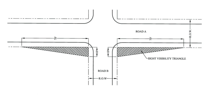
- Adequate Sight Distances. Adequate sight distances (see Figure 3B. Sight Visibility Triangle) along a proposed road shall be provided by:
- Choosing a good location for the right-of-way and clearing sight visibility triangles when constructing the road (the minimum sight distance is 70 feet along the “existing” road right-of-way and ten (10) feet along the “new” road right-of-way).
- Providing an adequate place for vehicles to stop before entering the road.
- Providing an apron design at proposed intersections to permit a vehicle to enter when another vehicle is waiting to turn.
Figure 3B. Sight Visibility Triangle
Not to Scale
- Gates. Entry gates shall be constructed and maintained as required by and in accordance with Chapter 47 of the Henderson County Code, Entry Gates, and SR 3.7 (Gates and/or Guardhouses).
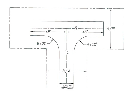
- Dead Ends, Cul-de-sacs and Turnarounds. Vehicle turnaround areas shall be provided at the end of all dead-end roads (excluding private driveway easements) that exceed 300 feet. Loop roads should be encouraged where possible in lieu of cul-de-sac or turnarounds. The reviewing agency may also require installation of turnarounds at:
- Intermediate locations along dead end roads with a centerline length of greater than 2,500 feet.
- The end of a phase of a project.
- An intermediate location along any road that exceeds 1,500 feet in length.
Acceptable alternative turnaround designs for residential subdivisions are shown in Figures 3C, 3D, and 3E. Turnaround areas of a dead-end road cul-de-sac shall have a radius of not less than 35 feet.
Figure 3C. Alternative Turnaround Design - Island
Not to Scale
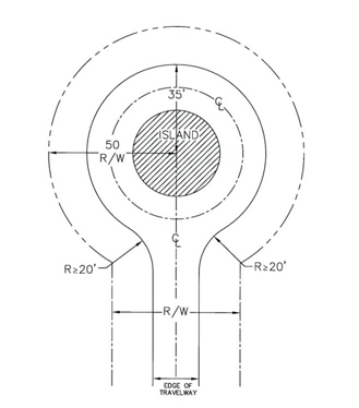
Figure 3D. Alternative Turnaround Design - Branch Turnaround
Not to Scale
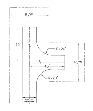
Figure 3E. Alternative Turnaround Design – T Turnaround
Not to Scale
- Bridges. Bridges shall:
- Be engineered to a minimum weight capacity of 50,000 pounds (For purposes of emergency management vehicle access) and documentation shall be provided to indicate such (the 50,000 pound weight capacity requirement shall not apply to driveways);
- Adhere to State Road Standards for drainage, hydraulics and minimum live load;
- Adhere to standards for vertical clearance for roads (See Table 3.3);
- Provide a travelway width not less than the travelway width of the road on either side of the bridge, and in no case less than 12 feet in width;
- Include a paved or gravel turnout on each end of the bridge to provide space for at least one (1) vehicle to safely pull over and allow an oncoming vehicle to traverse the bridge where the travelway width is less than 18 feet and is proposed to accommodate two-way traffic; and
- Provide adequate line-of-sight distances for safe operation of two-way traffic.
42-111. Private Road Standard Reductions
- Right-of-way Width Reduction. Right-of-way width requirements may be reduced to 30 feet in width where no more than five (5) lots are proposed and it is unlikely (due to design, topographic conditions or existing development) that any road contained therein would be extended to serve more than five (5) lots.
- Centerline Curve Radius Reductions. Centerline curve radius reductions may be reduced to:
- 80 feet where the existing cross slope on private subdivision collector roads is 15 percent or greater, or
- 60 feet where the existing cross slope on private subdivision limited local residential subdivision roads or private subdivision local residential subdivision roads is 15 percent or greater.
- Shoulder Width Reduction. Shoulder width shall be reduced for:
- Private subdivision local roads and private subdivision collector roads to a minimum of two (2) feet in cases where the existing cross slope is 20 percent or greater; and
- Private subdivision collector roads to a minimum of four (4) feet in cases where the existing cross slope is greater than ten (10) but less than 20 percent or greater.
- Cut and Fill Slopes. Cut and fill slopes shall be reduced to 1:1 where the existing cross slope is 20 percent or greater. Additional erosion control measures are required in areas where cut and fill slopes utilize this reduction. Enforced by the Erosion Control Administrator.
42-112. Reserved
42-113. Reserved
42-114. Reserved
42-114. General
Where the required improvements have not been completed, prior to the submission of the final plat for approval, the approval of said plat shall be subject to the applicant guaranteeing the installation of the improvements within thirty (30) months provided the following:
- A minimum of 25 percent of the on site improvements (based on the total project cost that the applicant is guaranteeing) is in place. The required improvements shall include rough grading for all proposed roads that are part of said improvement guarantee
- All required Federal, State and Local permits for the development must be issued with copies provided to the Subdivision Administrator (include any required U.S.Army Corps of Engineers permits, NCDENR permits, water supply and distribution system permits, wastewater collection and treatment system permits, approvals for the extension of electrical power service and other necessary utilities, and all applicable Federal and State permits).
- All associated design plans and construction specifications for the required improvements (i.e. roads, bridges, water and sewer infrastructure, stormwater infrastructure, pedestrian infrastructure, etc.) including the design engineer’s release of such approved plans are submitted to the Subdivision Administrator.
42-115. Cost Estimate Standards
Plans, specifications, quantities, unit costs and estimated total costs shall be provided by the applicant to the Subdivision Administrator. Cost estimates shall:
- Be prepared by a professional engineer licensed in N.C., or certified by a professional land surveyor or landscape architect who is routinely engaged in cost estimates and licensed in N. C., at the applicants’ expense. Water and sewer system infrastructure improvements shall be prepared by a professional engineer licensed in N. C. at the applicant’s expense.
- Provide a schedule for initiation and completion of work.
- Include separate estimates for roads, bridges, water and sewer infrastructure, stormwater infrastructure, pedestrian infrastructure, utilities (including electrical power, natural gas and communication lines), etc., consistent with the approved design plans construction specifications.
- Include separate estimates for any off-site infrastructure improvements such as roadways, stormwater system, water system, sanitary sewer system, etc., are required to be included in the improvement guarantee.
- Include all Federal and /or State mitigation fees due but not paid at the time of the execution of the improvement guarantee. Proof of payment for remediation fees shall be provided to the Subdivision Administrator.
- Include all professional engineering and land surveying fees associated with the bidding and award, construction contract administration and engineering certifications associated with the development of the infrastructure for the proposed development.
42-116. Improvement Guarantee Instrument
- Amount of Guarantee. The improvement guarantee shall be in the amount of 125 percent of the cost to complete the work as determined by cost estimates.
- Guarantee. The applicant shall guarantee the installation of such improvements in an amount equal to the improvement guarantee cost to complete the work as determined by cost estimates amount by either of the methods described below.
- Filing a performance or surety bond or an irrevocable standby letter of credit.
- Depositing a certified check or cash.
- Release of Funds. Portions of the improvement guarantee may be release as work progresses, provided the following:
- The applicant submits a new cost estimate as described in the §42-117.A (Amount of Guarantee) detailing the work that has been complete and the work that is remaining. The amount remaining under the improvement guarantee shall meet or exceed the cost of the remaining improvements.
- Funds shall not be released if the property is in violation of any laws until the violations are remedied to the satisfaction of the charging party.
- At total of not more than four (4) requests for release of funds shall be allowed. The first request for release is eligible when twenty-five (25) percent of the work is completed. The second and third request for release is eligible when fifty (50) percent and seventy-five (75) percent of the work is completed. The fourth and final release is eligible upon completion of all required improvements listed in the improvement guarantee. The release of funds must include a professional Engineer’s statement certifying the work has been satisfactorily completed.
42-117. Amount and Terms of Guarantee; Time Limits
- Approval. All guarantees shall be accompanied by a written agreement (performance agreement) specifying the terms and the amount of the guarantee. The Planning Director shall have the authority to approve all improvement guarantee applications taking into consideration the amount and terms of the guarantees for improvements (including time of initiation and completion of the work).
- Temporary Access and Construction Easement. The applicant shall provide temporary access and permanent construction easement s for all infrastructure improvements.
- Amount and Terms. The amount of the guarantee shall be sufficient to provide adequate funds to the County to ensure, in the case of default, the installation of all required improvements uncompleted at the time of default. All improvement guarantees shall comply with applicable statutory requirements and shall be satisfactory to the County Attorney or Staff Attorney as to form, sufficiency and manner of execution. Guarantees employing lending institutions shall require that those banking corporations be licensed to do business in North Carolina and be from a national association or FDIC registered group.
The following terms shall be stated in the performance agreement:
- The applicant shall be provided 15 days to identify a new security provider or prove alternate security where the security provider is in default, bankruptcy, or otherwise determined to be insolvent by the County after which time the County may redeem the improvement guarantee.
- The applicant shall provide the County with specific benchmarks for completion of work and, as a term of the agreement, should the applicant fail to meet the self-imposed benchmarks the county may redeem the improvement guarantee.
- If in violation of any other provision of this Chapter 42, Henderson County Land Development Code, where the applicant shall been notified of the violation, and the applicant has been provided the period for remediation authorized by the approving agency, and where applicant is in continued violation, the County may consider this to be a breach of the agreement and call the improvement guarantee to prevent further violation of Chapter 42, Land Development Code.
D. Time Limits. The improvement guarantee is valid for a period of eighteen (18) months from the date of execution.
E. Extensions. The Planning Director, upon proof of difficulty, may grant an extension for a maximum of (1) one additional year. Improvements not completed within thirty (30) months shall be in breach with the requirements of this section and the improvement guarantee and any and all monies and accrued interest shall be forfeited by the applicant.
F. Second Improvement Guarantee. If the Planning Director has found that the applicant has made a good faith effort in completing the required improvements within the thirty (30) months the County may allow the applicant to execute a second improvement guarantee. Said agreement much be in the form of cash on deposit equal to the cost as described in §42-117A (Amount of Guarantee) of the remaining improvements. The County shall assess and administrative fee equal to ten (10) percent of the new improvement guarantee monies.
42-118. Violations and Penalties
If an applicant of a subdivision is in violation of any County Regulations (including Soil Sedimentation and Erosion Control Permits) the County will not release the improvement guarantee prior to the expiration date unless the violations are corrected.
The County may charge for the cost for construction and project administration for any improvement guarantee that is executed.
42-119. Reserved
42-120. Reserved
42-121. Reserved
42-122. Reserved
42-123. Designation of Agent
The applicant for any subdivision review or approval procedure may submit, along with any initial application, an affidavit specifying an agent who may represent the owner in all matters.
42-124. Approval Prerequisite to Plat Recordation
Pursuant to NCGS §160D-801, and except where otherwise provided in this Chapter, no final plat of a subdivision within the jurisdiction of this Chapter shall be recorded by the Register of Deeds of Henderson County until it has been approved by the Subdivision Administrator, Technical Review Committee, or Planning Board as provided herein. The Register of Deeds shall not file or record a plat of the subdivision of land, any part of which is located within the jurisdiction of this Chapter that has not been approved in accordance with these provisions. In addition to meeting the requirements of this Chapter, subdivisions proposed within designated water supply watershed areas shall be subject to the provisions of the Water Supply Watershed Protection requirements of this Chapter, and the Water Quality Administrator or his designee shall certify on such plats that the subdivision complies with the provisions of the Water Supply Watershed Protection requirements of this Chapter.
42-125. Certification of Exemptions
Any plat of property exempted from the regulations of this Chapter shall be certified by the Subdivision Administrator or a professional land surveyor as exempt, prior to such plat being recorded. Such plat is not exempt from the other requirements set forth in this Chapter or any other local ordinances. Pursuant to NCGS §47-30 (f) 11 (Duty of the Surveyor), a professional land surveyor may certify that such plat represents an exception to the definition of subdivision and is not subject to the provisions of this Article III (Subdivision Regulations). Such plat may be recorded without being certified by the Subdivision Administrator. Any exemption from the regulations of this Chapter shall not be deemed an exemption from any other applicable ordinance. Any court-ordered subdivision should comply, to the maximum extent possible, with the provisions of this Chapter.
42-126. Plat Approval Required for Building Permit
No building permit may be issued for any construction on any proposed lot shown on a development plan until a final plat has been approved and recorded, except that a building permit may be issued for one (1) structure on one (1) lot shown on any approved development plan prior to recordation of a final plat. The Building Services Department shall deny building permits for subdivision lots created in violation with the terms and conditions of this Chapter.
42-127. Land Auctions
Where application for major or minor subdivisions is made with the intent that such divided property will be sold at land auction, the final plat shall clearly state the following: "The property herein is to be sold by auction. Any further subdivisions must meet applicable standards set forth in the Henderson County Land Development Code." In addition, restrictive covenants regarding road maintenance for any dedicated rights-of-way must be approved in advance by the appropriate reviewing agency and recorded prior to such auction.
42-128. Limitations on Applications Pending
Only one (1) application for a subdivision may be reviewed by any reviewing agency at any one (1) time on any of the original property boundaries. An application is only valid for up to one (1) year after its submission to the Planning Department. Applications submitted over one (1) year prior must be updated and resubmitted.
42-129. Violations and Penalties
If an applicant of a phased minor or is in violation of any regulation in Article III (Subdivision Regulations) for the first phase of the subdivision then the applicant will not be allowed to continue developing future phases of the subdivision and any County issued permits may be revoked or suspended by the County. Upon verification by Henderson County Planning Staff that the subdivision no longer violates the provisions of Article III (Subdivision Regulations), subdivision approval and any suspended permits will become valid. The applicant may reapply pursuant to applicable provisions of the Land Development Code to have any revoked permits reinstated.