Ecusta Trail Access Information
The Ecusta Trail is federally railbanked. What does that mean?
Railbanking, established in 1983 as an amendment to Section 8(d) of the National Trails System Act, is a voluntary agreement between a railroad company and a trail sponsor (such as a trail organization or government agency) to use an out-of-service rail corridor as a trail until a railroad might need the corridor again for rail service. This interim trail use of railbanked corridors has preserved thousands of miles of rail corridors that would otherwise have been abandoned (Source: Rails to Trails Conservancy).
Appropriate Trail Access = Trail User Safety
A trailhead is a designated public access point to a trail, often—but not always—located at its terminus points. The trailhead is typically a place where users begin or end their journeys and where they get oriented to the trail or trail network. On the Ecusta Trail, there will be a trailhead in downtown Hendersonville, one near the "halfway point", and a trailhead where the trail crosses the county line, once construction is complete. Until then, there are already other minor access points along the trail, for example at road crossings and at designated businesses, for users to gain entry. As the County establishes these access points, a map will be posted to tell users where they can safely enter the trail. As of now, the trail is not officially open. A map will be posted before construction is completed and will be maintained to reflect the accurate status of encroachment permit holders.
Henderson County has formalized the process for property owners to connect the trail to ensure the safety of trail users. Each new access point creates what's called a point of conflict, where traffic is moving in a perpendicular direction than those on the trail. This can create dangerous conditions, especially for children and pets. It's also important for Emergency Services to know where all access points are in the case on an emergency. Property owners who apply for a trail encroachment permit and are awarded have their location electronically mapped as a point for Emergency Services to locate.
Please click here to view the County's adopted Ecusta Trail Encroachment Policy.
Contact
For more information and to apply for an encroachment agreement, please contact the County Engineer:
- Marcus Jones, PE
- (828) 694-6560
- mjones@hendersoncountync.gov
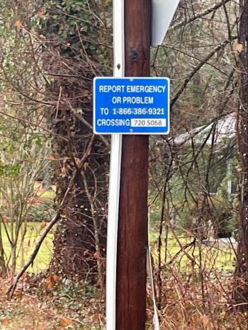
Any road crossing that has the blue sign is a permitted trail access point. Trail users should not enter the trail in areas where these signs are not present, as there may be a safety concern. Any property owner who wishes to create a permitted trail access point should contact the County Engineer, Marcus Jones, for more information on the process and the County's encroachment policy.